Tag Archives: snow

Winter weather – What does that weather warning mean?

You have seen and heard the warnings but do you know what they really mean?

We all are familiar with the crawls on the TV screen or the announcements on the radio for winter weather advisories such as Winter Storm Watch, Blizzard Warning, Freeze Warning and more. But, how many of us really know what those mean? There is very specific criteria the National Weather Service follows in issuing these watches and warnings and there are important differences between all of them.

In this second in a series on Winter Weather Preparedness from the National Weather Service, ThorntonWeather.com helps you understand what all of these mean so you can be better prepared.

PUBLIC INFORMATION STATEMENT
NATIONAL WEATHER SERVICE BOULDER CO
600 AM TUE OCT 18 2022

From the National Weather Service:

What does that warning mean?

When a warning is issued during the winter season, will you know what it means, and will you know how to respond? During this Colorado Winter Weather Preparedness Week, please become familiar with our list of potentially life-saving winter weather products.

OUTLOOKS

A Hazardous Weather Outlook is issued daily by the National Weather Service office in Boulder Colorado. The outlook provides information on potentially hazardous weather out to 7 days into the future. Also, the Weather Story, a graphic of expected hazardous weather, is posted daily on National Weather Service web sites.

WATCHES AND WARNINGS

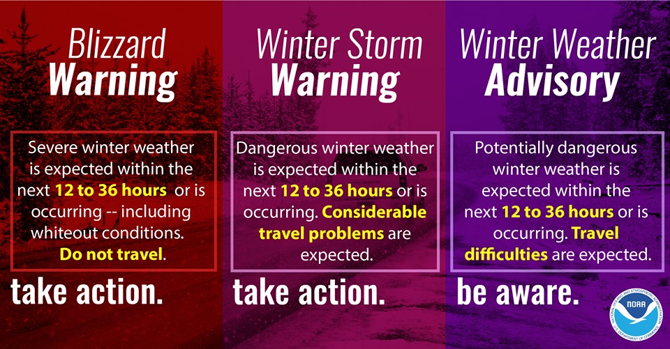
A Winter Storm Watch is issued when hazardous winter storm conditions are possible within the next 3 to 4 days, but the timing, intensity, or occurrence may still be uncertain. In contrast, a Winter Storm Warning is issued for potentially life-threatening winter storm conditions, such as heavy snowfall or a combination of snowfall and blowing snow, which are likely to occur within the next 1 to 2 days. Impacts such as timing of winter weather on rush hour are also considered when issuing Watches and Warnings.

Winter Storm
Plains: 6″ in 12 hours, 8″ in 24 hrs
Mountains: 8″ in 12 hours, 12″ in 24 hours
And Impacts

Winter Weather Advisory
Plains: 3-6″ in 12 hours, 4-8″ in 24 hours
Mountains: 4-8″ in 12 hours, 6-12″ in 24 hours
And Impacts

Blizzard
Sustained wind or frequent gusts 35 mph or greater, AND
Considerable falling/blowing snow with visibility less than 1/4 mile, for at least 3 hours

ADVISORIES

Advisories for winter weather are issued for potentially hazardous conditions which are considered more of a nuisance than a life-threatening situation. However, if caution is not taken the advisory events could become life-threatening. Impacts such as timing of winter weather on rush hour are also considered when issuing Advisories.

Winter Weather Preparedness Week in Colorado will continue through Saturday.

Winter weather watches and advisories.

Colorado Winter Weather Preparedness Week introduction

Don't be caught off guard by winter weather! Remember the Christmas Eve Blizzard of 1982? Be prepared!
Don’t be caught off guard by winter weather! Remember the Christmas Eve Blizzard of 1982? Be prepared!

Winter weather in Colorado can be an inconvenience but more than that it can be deadly.  Emergency preparedness for major winter storms – as well as for other types of severe weather – is an important part of living in a state where conditions can change wildly from one moment to the next.

To help raise awareness of the need to be prepared for these occasions, the week of October 16th to October 22nd has been proclaimed Winter Weather Preparedness Week in Colorado.

The National Weather Service will be issuing Public Information Statements each day this week to highlight the dangers of winter weather and how best to be prepared.  ThorntonWeather.com will be posting these important messages here to help you be prepared.  Please take the time to read and heed these messages – your life and the lives of your loved ones could depend on it.

  • Stay up to date with Thornton’s weather: ‘Like’ us on Facebook and follow us on Twitter.

From the National Weather Service:

PUBLIC INFORMATION STATEMENT
NATIONAL WEATHER SERVICE BOULDER CO
600 AM MDT SUN OCT 16 2022

..Winter Weather Preparedness Week in Colorado…

The week of October 16th through October 22nd is Winter Weather Preparedness Week in Colorado. This is an excellent time for all individuals, families, businesses, schools, and media outlets to review their winter storm preparedness plans. It is especially important for all new arrivals to the state to become familiar with the National Weather Service watch and warning definitions, as well as winter safety procedures.

Snow in Colorado is important to the farmers, the ski areas, and for filling up reservoirs. However, winter storms often bring heavy snow, bitter cold air, high winds, low visibilities and slick roads. This can lead to dangerous travel conditions and other life threatening situations such as avalanches and very frigid wind chill temperatures.

To help you prepare for these hazards this coming winter, the National Weather Service will issue statements throughout the week to discuss:

Intro Winter Weather Preparedness Week
Part 1 Winter travel safety
Part 2 Watches…warnings…and advisories
Part 3 High winds
Part 4 Wind chill temperatures and hypothermia
Part 5 Avalanche safety
Review Winter Weather Preparedness Week review

The Mile High City’s lack of snow is now one for the record books

As of today, Denver has broken the record for the latest measurable snowfall on record. The old record for latest snowfall was November 21 1934.

Today, it has been 215 days since the Mile High City has received measurable snowfall and we will lengthen that record. There is a slim chance for some snow Wednesday night but, as the National Weather Service said this morning, “It is likely Denver will not receive its first snowfall until December.”

Denver’s earliest snowfall on record was September 3, 1961. The average date of the first snow is October 18th.

September snow in Denver is not entirely uncommon

Denver September Snow History. (ThorntonWeather.com)
Denver September Snow History. Click for larger view. (ThorntonWeather.com)

There is lots of talk (and hype!) about next week’s storm and the potential for our first snowfall of the season. While it is somewhat unusual to get snow so early in the season, it is far from unprecedented and not near as rare as you might think.

Whipping out the weather history books, we see that snow has fallen in 28 Septembers in the 139 years since the National Weather Service began recording snow in the Mile High City. That equates to about 20% of the years.

It has, however, been quite a while since we have seen one, the most recent occurring in 2000. That was the last in a stretch in which six out of eight years saw September snow.

Our earliest snowfall on record came on September 3, 1961 when 4.2 inches of the white stuff fell. The average date of Denver’s first snow is October 18th.

Most concerning about these early season snows is the potential for tree damage and power outages. Like spring storms, early season snows are usually quite wet and heavy and have the potential to wreak havoc, even if there isn’t much to them.

Deadly blizzards lash Europe, poor hardest hit

Heavy snowfall and deadly blizzards lashed Europe Thursday, forcing Geneva’s busy airport to close, as the region shivered in a deep freeze that has gripped countries from the far north to Mediterranean beaches in the south. … were often hardest hit. The Siberian cold front — dubbed the “Beast from the East” in Britain, “Siberian bear” by the Dutch and the ” snow cannon” by Swedes — on Thursday forced Geneva airport… Continue reading Deadly blizzards lash Europe, poor hardest hit

Watch Beautiful Snow Tornado Blow Through a Picturesque Austrian Village

This video of a snow tornado – also known as a “gustnado” – blowing through an Austrian village is going viral after it was published on Tuesday. Adventurer Peter Maier was driving past the small town of Stall when he saw the winter wind whip up the beautiful cyclone. Continue reading Watch Beautiful Snow Tornado Blow Through a Picturesque Austrian Village

Video: Thornton’s surprising pre-Christmas snow

We were expecting snow but not quite as much as received.  The storm that hit yesterday evening delivered a respectable 3.5 inches to Thornton as snow bands were quite strong and aided by upslope. Temperatures early this morning dipped well into the single digits, our coldest readings since January 7.

The time lapse video below captures four hours of the event as it started and then began to taper off.

Time lapse video: Thornton’s first snowstorm of 2017

Mother Nature seems intent on starting out 2017 the way she ended 2016 – cold.  A deep trough coupled with successive, reinforcing cold fronts sent Thornton’s mercury plunging and delivered a healthy shot of snow over the last couple of days.

Below is a time lapse video from our east webcam covering the majority of the event. It begins at 6:00am on Wednesday, January 4 when we were only seeing flurries.  From there you see the varying intensities of snow over the next 24 hours or so and end with some hints of blue sky but the afternoon of the 5th. In all, the video covers 36 hours in about 83 second.

Thornton ended with 7.1 inches of snow over the two-day period, our biggest snowfall of the season thus far.

A white Christmas in Thornton? Chances not great but not bad either

For many, the holiday season isn’t complete without a chill in the air and snow on the ground. Here in Denver we historically enjoy a better chance of experiencing the proverbial white Christmas than many places in the nation.

However, how the Mile High City fares in experiencing a white Christmas does depend on your definition of one.

If it means having actual snowfall on Christmas Day the chances aren’t that good. But, if simply having snow on the ground suffices, the chances improve considerably.

For a complete look at Denver’s Christmas weather statistics, click here.

Historical Probability of a White Christmas. (NOAA)

No October snow in Denver? Not unusual at all

The lack of measurable snow this October is not all that unusual. Click for larger view.

October will end with Denver not having seen any snow accumulation at all during the month.  While that, coupled with the overall lack of precipitation is concerning, not having snow is not at all unusual.

On average, the Mile High City receives 4.2 inches during October.

However, since record-keeping began in 1882, the month failed to yield any snow at all in 19 years since.  Further, in another 17 of those years we only received a trace.

This means that in 27% of the past 134 years, we saw essentially no accumulating snow in October.  So, the fact we won’t have received any this month is not uncommon.

The average date for our first snowfall is October 18th so we aren’t running all that far behind.  The earliest seasonal snowfall came on September 3, 1961 and the latest on November 21, 1934.

We have been exceedingly dry, really since the first part of June.

In October, Denver has recorded a mere 0.26 inches of precipitation while here in Thornton we have fared better with 0.43 inches.  On average we expect to see 0.97 inches so both locations are well below normal.

Perhaps more notable than the lack of moisture is the temperatures which have been unseasonably warm.

As of right now, the average temperature for the month is at 57.2 degrees in Denver, 55.1 degrees in Thornton.  This is running far above the historical October average temperature of 50.9 degrees.

Depending on temperatures between now and the end of the month, it is looking likely that October 2016 will finish somewhere in the top five or six warmest Octobers on record.