This is NOT the time to be outside. (michaeljames / FLICKR)
Of all the weather types associated with thunderstorms – hail, tornadoes, floods, etc – lightning is usually the most dangerous. In the United States there are an estimated 25 million cloud to ground lightning flashes each year and each one is a potential threat to life and property.
During the past 10 years there has been an annual average of 39 lightning fatalities in the United States. Last year, 23 people lost their lives due to lightning.
Colorado is ranked # 2 in lightning related deaths (2001 – 2010) so the danger this presents to life and property is very significant for us. It is interesting to note though that Colorado ranks only 32nd in the number of cloud to ground strikes over that same period. Which means, in short, we have fewer strikes than many other states and yet more deaths.
This highlights the fact that, quite frankly, folks here in Colorado are not aware of the dangers lightning presents and they do not take proper steps to protect themselves. One of the great things about Colorado are the outdoor activities we all enjoy, but there comes a time when we need to head indoors.
Straight line winds can be as damaging as a tornado. This image is from a park in Tennessee. (NWS)
During the spring and summer months in Colorado, a wide array of severe weather can strike. Tornadoes may grab all the headlines, but straight line winds and hail can do a great amount of damage in their own right – and they are more common.
Straight line winds are winds out of a thunderstorm and are classified as severe when they hit 58 mph. These winds can reach tornado and hurricane force and as a result, cause property damage and can injure and even kill animals and humans.
These winds are usually the result of air cooling rapidly due to precipitation or evaporation. As the cooler air is heavier than the surrounding warmer air, it rushes downward, accelerating toward the ground and spreads out as it hits, much like pancake batter being poured onto a griddle.
The Big Thompson Flood in 1976 claimed the lives of 144 Coloradoans and serves to remind us of the dangers of floods.
For much of Colorado, floods and flash floods present a grave danger to life and property. These usually are the result of one of two things – spring snow melt occurring rapidly or a severe thunderstorm. Colorado is very susceptible to flash flooding and these occur somewhere every year in the state.
The waters from flash floods can move with extraordinary speed and strike with little or not warning. Their force can be extremely destructive and when coupled with trees, dirt, rocks and other debris they carry downstream, they are deadly.
Flooding is the number one weather killer in the United States.
The 2008 Windsor Tornado highlights the very real danger twisters present in Colorado. Do you know when to do when one strikes?
One fact that may surprise those new to Colorado is that we are actually on the western edge of the infamous Tornado Alley. This large swath of land comprises much of the nation’s midsection and is a unique place as the United States sees more tornadoes than any other place on earth. In fact, tornadoes have been recorded in all 50 states including Alaska and Hawaii.
Closer to home, Colorado sees our share of these storms. In fact, one metro area county – Weld County – holds the distinction of being the “tornado capital of the world.” With 252 tornados from 1950-2011, no single county in the nation has had more tornadoes! Adams County is number two in the state and isn’t far behind with 156 over that same period. Granted these numbers are skewed a bit simply due to the sheer size of those counties, but it does serve to highlight the real danger that tornadoes present.
One common myth is that tornadoes don’t strike metropolitan areas. This has been disproved many times including here in Colorado in 1981 when an F2 tornado struck Thornton. Image courtesy the City of Thornton archives.
The most well known tornado outbreak in the metro area occurred on June 15, 1988. Five tornadoes resulted in seven injuries and damage in excess of $15 million.
The greatest threat for tornadoes occurs during late spring and early summer when you have a combination of heat and moisture in the lower atmosphere. Here in Colorado, tornadoes are frequent from May through August with June being the most active month.
Colorado ranks 10th in terms of the number of tornadoes with 1,911 events from 1950-2011. One good thing is that our high altitude and drier air do make it harder for the monster supercells that spawn the biggest tornadoes to form. Most of our tornadoes are small and short lived. Further, thanks to the wide open spaces of the eastern half of our state, many strike sparsely populated areas. This is reflected in the fact that we rank 38th for tornado related deaths.
The 2008 Windsor tornado highlighted just how dangerous weather in Colorado can be. Are you and your family prepared? Do you know what the watches and warnings all mean?
We’ve all seen TV or Internet news of a weather related watch or warning being issued. But, how many really know what they mean? There is a pretty big difference between the two and it is important to be aware just what it means to you so you can take the appropriate precautions.
Dozens of weather related fatalities occur every year in Colorado, many simply out of ignorance. Taking the time to be aware of the conditions around you and taking appropriate action will keep you from becoming a statistic.
Naturally you can get information on current advisories from television as local stations usually do a good job of “crawling” them on the screen when they are issued. This works well if you have a TV available but if not, the radio would be a secondary source. The Internet and the National Weather Service’s website are a great one when at a computer.
The problem with relying on news media or the Internet is that their ability to warn you of a developing weather situation is dependent on your monitoring them. Severe weather can strike without little warning. How will you know if severe weather is about to strike if you don’t have the TV or radio on?
Your first line of defense – NOAA All Hazards Radio
For just about anywhere, a special radio that picks up the NOAA’s All Hazard Radio broadcasts is the way to go and provides information from the source. Oftentimes simply called a weather radio, we highly recommend every household have one of these.
These radios are relatively inexpensive and allow you to be immediately notified of official National Weather Service warnings, watches, and forecasts as well as other hazard information like earthquakes, avalanches, chemical spills, and even AMBER alerts. In fact, with these radios, you will be notified at the exact same time the news media is made aware giving you a head start on preparing for a developing situation.
Many people now have smartphones that allow for downloadable apps and weather-related ones are among the most popular.
All of these applications have a number of weather related features in common. All provide current conditions for either the location the user is in now or for saved locations and all provide some sort of radar.
Most can be configured to sound an alert when the National Weather Service issues a watch or warning. While they are no substitue for a weather radio, these apps provide you with immediate notification no matter where you are at.
In 1981 a tornado ripped through Thornton and caused major damage. Last year, funnel clouds were spotted across much of the area. Image courtesy City of Thornton archives.
As is customary as we get further into spring, this coming week has been proclaimed Severe Weather Awareness Week. This is an opportunity for the public to get reacquainted with the dangers severe weather presents in Colorado.
Tornadoes, lightning, hail, severe wind and flooding are very real hazards that Coloradans face every year during severe weather season. It is important that you know what to do to protect you and your family.
Just 12 years ago in what was Denver’s weather story of the year, we suffered through a period of unusually severe weather including a tornado that ripped through the Southlands Mall.
Thirteen years ago on May 22nd an EF3 tornado raced north through Weld and Larimer counties resulting in one fatality near Windsor and causing several injuries and destroyed or heavily damaged hundreds of homes.
In conjunction with the National Weather Service’s statements on Severe Weather Awareness Week, ThorntonWeather.com will be publishing our Severe Weather 101 series. Each day this week a weather hazard will be discussed in depth and we will outline protective measures you can take to keep yourself and your family safe. Please be sure to check back every day to read these important message.
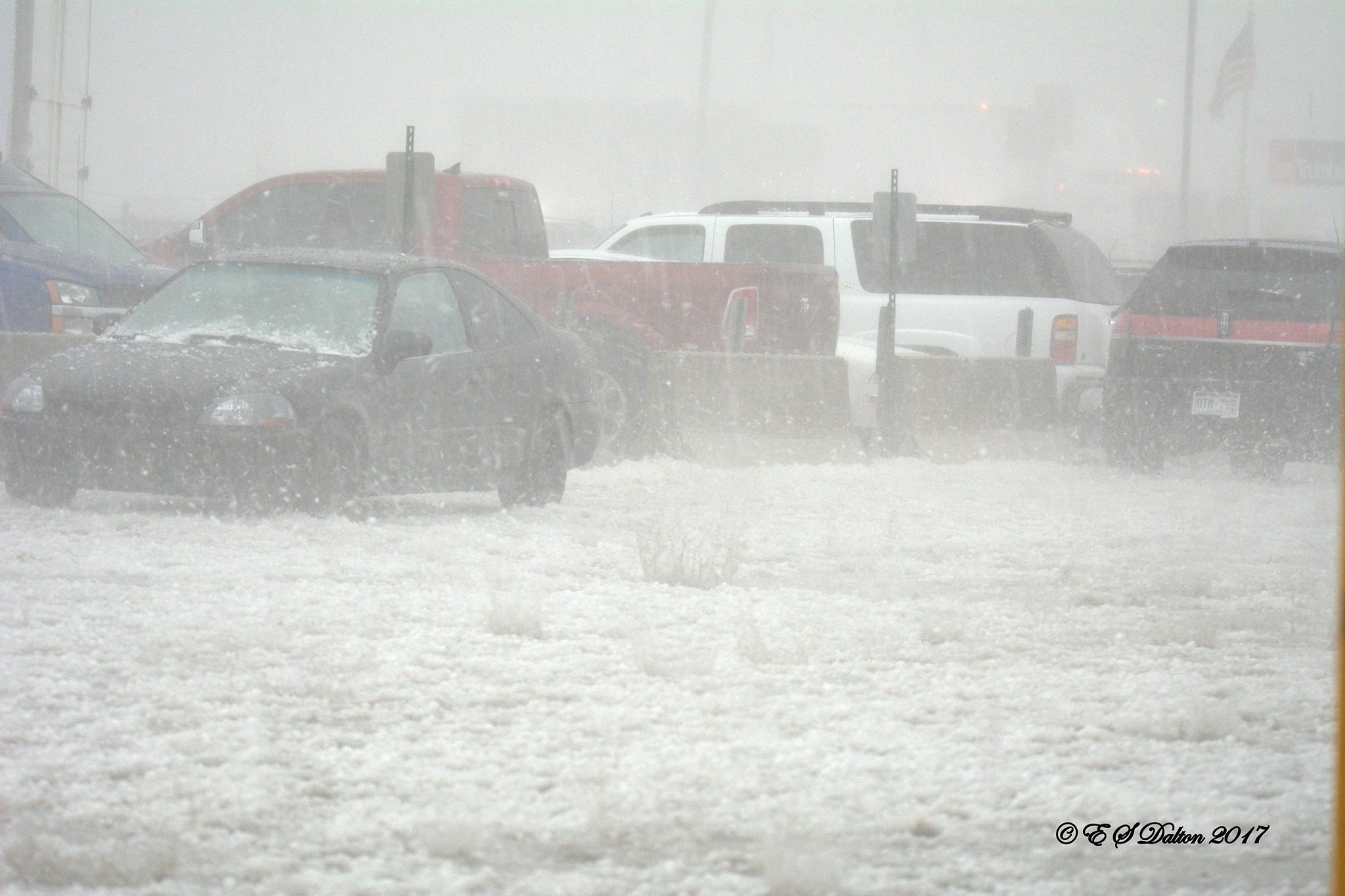
May 8, 2017 – Hail pounds an industrial area just northwest of downtown Denver. (Ed Dalton)
The weather forecast for May 8, 2017 was relatively typical for this time of year with pleasant temperatures and a sunny morning. We also wrote about the usual chance for PM thunderstorms but cautioned they could be potent saying, “Strong winds, large hail and possibly an isolated tornado will be possible.”
Little did we know just how potent they would be.
The thunderstorms that rolled through the Denver metro area that day brought monstrous hail, destroying windows, roofs, siding and vehicles.
As expected, the worst of the storms stayed south of Thornton but the areas that were hit from Golden to just north of downtown Denver were devastated. The tally to date is $2.3 billion in damage.
Fox 31 did a special on the storm last year and it makes for an interesting look back – and a reminder of the power of Mother Nature.
Since its launch in November and going online a few weeks later, the GOES-16 weather satellite has already sent back a trove of invaluable data to its operator, the National Oceanic and Atmospheric Administration (NOAA). And the country’s most advanced weather satellite began Monday transmitting to Earth images and data related to lightning over the Western… Continue reading New Weather Satellite Sends First Lightning Images→
Severe weather struck the plains of Colorado on Saturday spawning multiple tornadoes. The two most powerful of these, one near Wiggins and another near Wray, have been rated EF-2s on the Enhanced Fujita Scale.
Damage and injuries from both twisters were relatively light, certainly not as bad as they could have been.
The tornado west of Wiggins crossed I-76 and traveled nearly 9 miles reaching 3/4 of a mile wide at one point. It ripped through a private campground at Empire Reservoir damaging and destroying multiple RVs. There were some minor injuries with the storm.
Further east, near Wray, multiple tornadoes were reported, the most significant of which damaged three residences and businesses near the town’s borders. It traveled about 8 miles and at its widest was 440 yards across.
Three other tornadoes were confirmed near Wray although they caused no damage and were rated EF-0s.
Below is some amazing video of the tornado near Wray. Scroll below that for the detailed damage survey from the National Weather Service.
PUBLIC INFORMATION STATEMENT
NATIONAL WEATHER SERVICE DENVER/BOULDER CO
314 PM MDT MON MAY 9 2016

...NWS DAMAGE SURVEY FOR 05/07/16 TORNADO EVENT ACROSS MORGAN
AND WELD COUNTIES - UPDATE # 1...

.UPDATE...ADDING ADDITIONAL TORNADOES.

.OVERVIEW...A TORNADO DEVELOPED JUST SOUTH OF INTERSTATE 76 OVER
WELD COUNTY AND THEN MOVE NORTH ACROSS EMPIRE RESERVOIR BEFORE
LIFTING 2 MILES NORTHWEST OF ORCHARD IN MORGAN COUNTY.  THERE WERE
TWO MINOR INJURIES WHEN A CAMPER WAS ROLLED OVER.  IN ADDITION SEVERAL
CAMPERS WERE DESTROYED AT EMPIRE RESERVOIR.

.TORNADO # 1

RATING: EF-2
ESTIMATED PEAK WIND: 115-120 MPH
PATH LENGTH /STATUTE/: 8.8 MILES
PATH WIDTH /MAXIMUM/:  1320 YARDS
FATALITIES: 0 INJURIES: 2

START DATE:             MAY_07_2016
START TIME:             255 PM_MDT
START LOCATION:         5 WEST OF WIGGINS/WELD COUNTY


END DATE:               MAY_07_2016
END TIME:               310 PM_MDT
END LOCATION:           2 NORTHWEST OF ORCHARD/MORGAN COUNTY


SURVEY_SUMMARY:  MOST OF THE DAMAGE WAS EF0 TO EF1 HOWEVER THERE
WERE A FEW AREAS OF EF2.  THE TORNADO WAS LARGE AND 3/4 OF A
MILE WIDE AT ITS PEAK.

.TORNADO # 2...

RATING:                 EF-0
ESTIMATED PEAK WIND:    85 MPH
PATH LENGTH /STATUTE/:  0.5 MILES
PATH WIDTH /MAXIMUM/:   50 YARDS
FATALITIES:             0
INJURIES:               0

START DATE:             MAY_07_2016
START TIME:             315 PM_MDT
START LOCATION:         6 NORTH OF ORCHARD/MORGAN COUNTY

END DATE:               MAY_07_2016
END TIME:               316 PM_MDT
END LOCATION:           7 NORTH OF ORCHARD/MORGAN COUNTY


.TORNADO # 3...

RATING:                 EF-0
ESTIMATED PEAK WIND:    85 MPH
PATH LENGTH /STATUTE/:  0.5 MILES
PATH WIDTH /MAXIMUM/:   50 YARDS
FATALITIES:             0
INJURIES:               0

START DATE:             05_07_2016
START TIME:             325 PM_MDT
START LOCATION:         14 SOUTHWEST NEW RAYMER/WELD COUNTY

END DATE:               05_07_2016
END TIME:               326 PM_MDT
END LOCATION:           13 SOUTHWEST NEW RAYMER/WELD COUNTY


.TORNADO # 4...

RATING:                 EF-0
ESTIMATED PEAK WIND:    85 MPH
PATH LENGTH /STATUTE/:  0.5 MILES
PATH WIDTH /MAXIMUM/:   50 YARDS
FATALITIES:             0
INJURIES:               0

START DATE:             05_07_2016
START TIME:             335 PM_MDT
START LOCATION:         7 NORTHWEST FORT MORGAN/MORGAN COUNTY

END DATE:               05/07/2016
END TIME:               336 PM_MDT
END LOCATION:           8 NORTHWEST FORT MORGAN/MORGAN COUNTY

PUBLIC INFORMATION STATEMENT
NATIONAL WEATHER SERVICE GOODLAND KS
500 PM MDT SUN MAY 8 2016 /600 PM CDT SUN MAY 8 2016/

THIS INFORMATION IS PRELIMINARY AND SUBJECT TO CHANGE PENDING
FURTHER REVIEW OF DOPPLER RADAR, STORM SPOTTER REPORTS AND STORM
VIDEOS, WHICH ARE STILL ARRIVING INTO THE OFFICE.

...NWS DAMAGE SURVEY FOR 05/07/2016 TORNADO EVENT...

.TORNADO #1...

RATING:                 EF-2
ESTIMATED PEAK WIND:    130 MPH
PATH LENGTH /STATUTE/:  8 MILES
PATH WIDTH /MAXIMUM/:   440 YARDS
FATALITIES:             0
INJURIES:               0

START DATE:             MAY 07 2016
START TIME:             551 PM MDT
START LOCATION:         2 N WRAY

END DATE:               MAY 07 2016
END TIME:               616 PM MDT
END LOCATION:           10 NNE WRAY

TORNADO PATH WAS ONLY SURVEYED BETWEEN 2 AND 5 MILES NORTH OF
WRAY ALONG AND JUST EAST OF HIGHWAY 385. TORNADO LIKELY CONTINUED
WELL NORTH-NORTHEAST OF WRAY BUT LACK OF ROADS PREVENTED FURTHER
SURVEY. THREE RESIDENCES AND TWO BUSINESSES NORTH OF WRAY WERE
IMPACTED...MAJORITY OF TRACK WAS OVER OPEN COUNTRY.


.TORNADO #2...

RATING: EF-0
ESTIMATED PEAK WIND:    85 MPH
PATH LENGTH /STATUTE/:  0.5 MILES
PATH WIDTH /MAXIMUM/:   25 YARDS
FATALITIES:             0
INJURIES:               0

START DATE:             MAY 07 2016
START TIME:             410 PM MDT
START LOCATION:         4 N HEARTSTRONG

END DATE:               MAY 07 2016
END TIME:               411 PM MDT
END LOCATION:           5 N HEARTSTRONG


.TORNADO #3...

RATING:                 EF-0
ESTIMATED PEAK WIND:    85 MPH
PATH LENGTH /STATUTE/:  3 MILES
PATH WIDTH /MAXIMUM/:   50 YARDS
FATALITIES:             0
INJURIES:               0

START DATE:             MAY 07 2016
START TIME:             454 PM MDT
START LOCATION:         4 N ECKLEY

END DATE:               MAY 07 2016
END TIME:               458 PM MDT
END LOCATION:           7 N ECKLEY


.TORNADO #4...

RATING:                 EF-0
ESTIMATED PEAK WIND:    85 MPH
PATH LENGTH /STATUTE/:  1 MILE
PATH WIDTH /MAXIMUM/:   50 YARDS
FATALITIES:             0
INJURIES:               0

START DATE:             MAY 07 2016
START TIME:             539 PM MDT
START LOCATION:         3 S WRAY

END DATE:               MAY 07 2016
END TIME:               541 PM MDT
END LOCATION:           2 S WRAY

THE ENHANCED FUJITA SCALE CLASSIFIES
TORNADOES INTO THE FOLLOWING CATEGORIES.

EF0...WEAK......65 TO 85 MPH
EF1...WEAK......86 TO 110 MPH
EF2...STRONG....111 TO 135 MPH
EF3...STRONG....136 TO 165 MPH
EF4...VIOLENT...166 TO 200 MPH
EF5...VIOLENT...>200 MPH

NOTE:
THE INFORMATION IN THIS STATEMENT IS PRELIMINARY AND SUBJECT TO
CHANGE PENDING FINAL REVIEW OF THE EVENTS AND PUBLICATION IN
NWS STORM DATA.
The weather seemed to dominate headlines in 2015 — not one continent was spared from some sort of extreme weather event. Antarctica The southernmost continent, mostly covered in ice, kilometres deep in places and spread over 14 million square kilometres, recorded its warmest day on record in 2015. On March 24, temperatures at Esperanza Base, just… Continue reading From ‘biblical’ floods to deadly heat, 2015 was a year of weather worsts→
Weather, natural disasters & climate news and information.


 For just about anywhere, a special radio that picks up the