Tag Archives: wind

Severe Weather 101 – Severe Weather Awareness Week wrap up

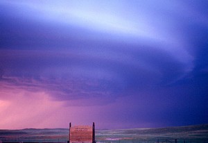
Supercell thunderstorms like this can be beautiful - but they can also be deadly. Do you know what to do when severe weather strikes? (Stormscape Photography / FLICKR)
Supercell thunderstorms like this can be beautiful – but they can also be deadly. Do you know what to do when severe weather strikes? (Stormscape Photography / FLICKR)

Over the past week we have highlighted some of the severe weather hazards that we face in Colorado every spring and summer in our Severe Weather 101 series.  The dangers these present are significant and not to be taken lightly.

Tornadoes grab most of the headlines and certainly are a danger however others like lightning and flooding are more common and actually claim more lives.  We ask all of our readers to please, take the time to review these important articles – they could save yours and your family’s lives!

The National Weather Service has published a nice wrap up of Severe Weather Awareness Week that covers all the basics – see it below.  For more in depth information, please use the links at the bottom to view each article on our Severe Weather 101 series.  Be safe and be weatherwise!

PUBLIC INFORMATION STATEMENT
NATIONAL WEATHER SERVICE GRAND JUNCTION CO
600 AM MDT SAT APR 16 2022

SEVERE WEATHER AWARENESS WEEK IN REVIEW

Severe Weather Awareness Week in review…

Severe Weather Awareness Week in Colorado concludes today. During the past week we have presented information and safety rules for tornadoes, lightning and wildfires, floods and flash floods, straight-line thunderstorm winds, hail, and our warning programs.

We will now review some of the most important safety rules in our effort to build a Weather-Ready Nation.

Be weather-wise by staying informed on expected weather in your area. The National Weather Service is typically aware of the potential for severe weather many hours or even days before any severe weather watches or warnings are issued, providing forecast products to heighten your awareness. A Weather Story product is posted each day on National Weather Service Internet pages and Facebook pages which includes a map and text on possible hazardous weather expected within the next seven days.

A Hazardous Weather Outlook is also issued daily with information on possible hazardous weather through the next seven days. A watch is issued when conditions for severe weather or flooding become possible. A warning is then issued when life threatening conditions are imminent or occurring.
Tornadoes

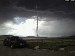
Tornadoes can even strike in mountain areas. In 2008 on August 23rd, this rope tornado struck Park County near Eleven Mile Reservoir. Image courtesy Jerry Bivens.

The best way to protect yourself from tornadoes is to have a plan of action. The safest place to be if a tornado approaches is in a basement or safe room within a well-built structure, or in an underground storm shelter. If none of these options are available, move to a hallway or a small interior room on the lowest floor, usually this is a closet or bathroom. Get under a heavy piece of furniture or in a bath tub and cover yourself with blankets. Remember, the greatest risk of injury from tornadoes is from flying debris.

Modular homes and mobile homes, even those tied down, offer little protection from tornadoes. If a tornado approaches, leave those locations and seek safety in a nearby sturdy building or storm shelter.

If you are driving in open country and see a tornado, if time permits, the best thing to do is simply drive away from the tornado path. Do not take shelter beneath a highway overpass. Wind speeds may actually be higher in these areas and often become collection points for debris.

If you are caught outside and cannot seek shelter inside a sturdy structure, crawl into a culvert or lie down in a narrow ditch or ravine and cover your head. But remember that the worst place to be when a tornado threatens is outside in the midst of flying debris.

Lightning

Lightning usually kills and injures more people in Colorado than any other thunderstorm hazard. Lightning also causes many wildfires.

The best defense to protect yourself against a lightning strike is to plan ahead and avoid being caught where you might be vulnerable. Check weather forecasts prior to venturing out, especially if you are heading into the mountains. Plan outdoor activities early in the day before storms develop.

If thunderstorms threaten, seek shelter in a building or in an enclosed metal-roof vehicle, making sure all windows and doors are closed. Never seek shelter under an isolated tree. During thunderstorms, stay off corded telephones, away from electrical devices, and away from plumbing. Also get out of shower stalls, bath tubs, swimming pools and lakes when lightning is nearby.

You should wait at least 30 minutes after the last sound of thunder before resuming outdoor activities. When thunder roars…go indoors.
Floods and Flash Floods

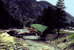
The Big Thompson Flood in 1976 claimed the lives of 144 Coloradoans and serves to remind us of the dangers of floods. (USGS)

When flooding or flash flooding is possible, you should remain alert and be ready to quickly evacuate to higher ground or climb to safety. Flash floods often occur suddenly and without warning. You need to follow some basic flood safety rules:

  • Do not camp or park your vehicle along streams and washes, particularly during threatening conditions.
  • If you are near a river, be aware of water levels and be prepared to move to higher ground if river levels rise.
  • Do not enter areas that are already flooded.
  • If walking or fishing along a river, be aware that erosion from swift running water can cause river banks to collapse.
  • Never let your children play around high water, storm drains, viaducts or arroyos.

At least half of all flash flood fatalities are vehicle related. While driving your automobile, look out for flooding at highway dips, bridges and low areas. Two feet of moving water will carry away most vehicles. Never attempt to drive across a flooded road. And be especially cautious at night when it is difficult to see flood dangers.

Strong Straight-Line Winds

Straight-line winds from thunderstorms, including microbursts, can become quite strong, even reaching speeds in excess of 100 mph in extreme cases. When thunderstorms approach, high winds can suddenly develop, causing things on the ground to become swift moving airborne missiles with a potential force to injure or kill. As with any thunderstorm, seek shelter before the storm arrives.

Hail

This is one of the largest recorded hail stones which is more than 7 inches in diameter and fell in Nebraska in 2003. (NOAA)

Large hail can pose a danger to animals and people. Hail also produces considerable damage to crops and personal property each year in Colorado. Again, get indoors before thunderstorms arrive. A fall of small hail can suddenly change to a fall of very large ice missiles which can injure or kill. Make efforts to protect personal property before storms threaten.

Warning Notification

When thunderstorms threaten, tune to NOAA All-Hazards Weather Radio, The Weather Channel, or your local radio or television stations. Also check the Internet web site from the National Weather Service office serving your area. And if you have a relatively new cell phone you should receive Tornado and Flash Flood Warnings on your phone if you are in the area of the warning.

During threatening weather days, plan the actions you will need to take so that you will be prepared if dangerous weather conditions actually develop.

NOAA’s National Weather Service wishes you a safe severe weather season.

Severe Weather Awareness Week in Colorado concludes today. During the past week we have presented information and safety rules for tornadoes, lightning and wildfires, floods and flash floods, straight-line thunderstorm winds, hail, and our warning programs.


Severe Weather 101 – Hail and Wind

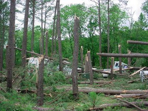
Straight line winds can be as damaging as a tornado. This image is from a park in Tennessee. (NWS)

During the spring and summer months in Colorado, a wide array of severe weather can strike. Tornadoes may grab all the headlines, but straight line winds and hail can do a great amount of damage in their own right – and they are more common.

Straight line winds are winds out of a thunderstorm and are classified as severe when they hit 58 mph. These winds can reach tornado and hurricane force and as a result, cause property damage and can injure and even kill animals and humans.

These winds are usually the result of air cooling rapidly due to precipitation or evaporation. As the cooler air is heavier than the surrounding warmer air, it rushes downward, accelerating toward the ground and spreads out as it hits, much like pancake batter being poured onto a griddle.

Continue reading Severe Weather 101 – Hail and Wind

Severe Weather Awareness Week in Colorado gets started

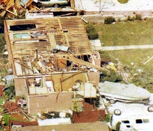
In 1981 a tornado ripped through Thornton and caused major damage. Last year, funnel clouds were spotted across much of the area. Image courtesy City of Thornton archives.

As is customary as we get further into spring, this coming week has been proclaimed Severe Weather Awareness Week.  This is an opportunity for the public to get reacquainted with the dangers severe weather presents in Colorado.

Tornadoes, lightning, hail, severe wind and flooding are very real hazards that Coloradans face every year during severe weather season.  It is important that you know what to do to protect you and your family.

Just 12 years ago in what was Denver’s weather story of the year, we suffered through a period of unusually severe weather including a tornado that ripped through the Southlands Mall.

Thirteen years ago on May 22nd an EF3 tornado raced north through Weld and Larimer counties resulting in one fatality near Windsor and causing several injuries and destroyed or heavily damaged hundreds of homes.

And of course in 1981 Thornton was the site of the worst tornado to ever strike the Denver metro area.

Tornadoes may get all the press but other severe weather can be damaging and deadly.

Just eight years ago, late summer flooding caused millions of dollars of damage across northeastern Colorado.  It was 45 years ago that thunderstorms brought a raging torrent of water down the Big Thompson and caused one of Colorado’s worst natural disasters.  Eleven years ago hail struck the Thornton area causing damage to homes and vehicles.

In conjunction with the National Weather Service’s statements on Severe Weather Awareness Week, ThorntonWeather.com will be publishing our Severe Weather 101 series.  Each day this week a weather hazard will be discussed in depth and we will outline protective measures you can take to keep yourself and your family safe.  Please be sure to check back every day to read these important message.

Continue reading Severe Weather Awareness Week in Colorado gets started

National Weather Service releases summary of New Year’s Eve windstorm

A windstorm pummeled northeastern Colorado on New Year's Eve 2011.

Northeastern Colorado closed out 2011 with pummeling high winds on New Year’s Eve.  Wind gusts of tropical and hurricane storm strength slammed into the region causing damage and claiming one life.

In the Denver metro area gusts approaching 50mph were common while areas in the foothills and mountains to the west and on the plains to the northeast saw much higher speeds.  Here in Thornton we recorded a maximum gust of 44.9mph in the predawn hours.

Following is a summary of the event from the National Weather Service:

Post-Storm Summary of the New Year’s Eve Windstorm

A fast moving upper level storm system, along with a deep low pressure system over Nebraska and high pressure building over Utah, combined to create a powerful windstorm across Northeast and North Central Colorado on December 31st. The high wind event began in the mountains after midnight Friday night, and then spread across the plains early Saturday morning. The height of the windstorm on the plains occurred around mid day when numerous gusts between 60 and 80 mph were reported.

The strong winds produced damage to fences and some roofs, and also knocked down trees resulting in power outages to approximately 19,000 residents. Some trucks were also blown off the road, and 1 fatality occurred due to a flying tree limb on U.S. Highway 36 north of Boulder.

Visibilities over the northeast corner of the state were also reduced significantly by a combination of blowing dust and blowing snow.

The following is a list by county of maximum wind gusts associated with this powerful windstorm…

Location Maximum Wind Gust

Adams…
Bennett 60 MPH
Front Range Airport 60 MPH

Arapahoe…
Deer Trail 59 MPH
Centennial 55 MPH

Boulder…
1 W Lyons 101 MPH
4 NW Boulder 84 MPH
Boulder 81 MPH
NCAR Mesa Lab 79 MPH
North Longmont 75 MPH
Boulder Municipal Airport 59 MPH
2 NNW Louisville 58 MPH

Broomfield…
Rocky Mountain Regional Airport 58 MPH

Clear Creek…
Berthoud Pass 94 MPH

Denver…
Buckley AFB 64 MPH
Denver International Airport 59 MPH

Douglas…
Centennial Airport 55 MPH
10 SSE Castle Rock 52 MPH
Highlands Ranch 50 MPH

Elbert…
10 E Parker 67 MPH
Elizabeth 55 MPH

Grand…
Berthoud Pass 94 MPH
11 N Kremmling 80 MPH
9 S Fraser 80 MPH

Jefferson…
3 SSE Pinecliffe 111 MPH
3 S Golden 86 MPH
Highway 72 and 93 Junction 79 MPH
National Wind Technology Center 77 MPH
3 NNW Morrison 76 MPH
4 S Rocky Flats 73 MPH
2 E Golden 67 MPH
2 E Northeast Lakewood 64 MPH
2 ENE Lakewood 64 MPH
3 W Conifer 62 MPH
Wheat Ridge 55 MPH

Larimer…
4 E Loveland 73 MPH
Natural Fort Rest Area 71 MPH
5 NW Fort Collins 67 MPH
3 NE Loveland 67 MPH
Wellington 63 MPH
4 E Fort Collins 63 MPH
Virginia Dale 62 MPH
Fort Collins 57 MPH

Lincoln…
3 W Cedar Point 80 MPH
Limon Airport 74 MPH

Logan…
Sterling Airport 73 MPH
Sterling 70 MPH
Crook 65 MPH

Morgan…
Wiggins 61 MPH

Park…
Kenosha Pass 79 MPH
Fairplay 77 MPH
Wilkerson Pass 58 MPH

Phillips…
4 E Haxtun 70 MPH
Holyoke 63 MPH
8 S Holyoke 62 MPH

Summit…
7 S Frisco 126 MPH
9 E Dillon 90 MPH
7 SSW Frisco 86 MPH

Washington…
Akron 75 MPH
Woodrow 73 MPH
5 NW Woodlin School 67 MPH

Weld…
4 ENE Eaton 80 MPH
3 NNW Cornish 79 MPH
2 NNW New Raymer 77 MPH
10 NE Pawnee Buttes 74 MPH
Briggsdale 72 MPH
9 NNE Briggsdale 72 MPH
7 N Rockport 70 MPH
Greeley Airport 67 MPH
4 ENE Severance 63 MPH
Eaton 63 MPH
1 N Greeley 62 MPH
6 E Berthoud 62 MPH
2 W Keenesburg 58 MPH
Milliken 56 MPH

12/31/11 - Here is surface pressure analysis (light blue lines) and infrared satellite image at 12 PM MST near the height of the windstorm.  Note the large difference in pressure between the surface low pressure over southeast Nebraska and high pressure centered over southern Idaho, and the resulting tight gradient across Colorado.  This is a key feature in windstorms across the Front Range and High Plains. (NWS)
12/31/11 - Here is surface pressure analysis (light blue lines) and infrared satellite image at 12 PM MST near the height of the windstorm. Note the large difference in pressure between the surface low pressure over southeast Nebraska and high pressure centered over southern Idaho, and the resulting tight gradient across Colorado. This is a key feature in windstorms across the Front Range and High Plains. (NWS)
12/31/11 - A 6 hour model forecast of 700 mb winds (approximately 10,000 ft MSL) and surface pressure.  700 mb wind strength is noted by flags (50kts) plus barbs (10kts for full & 5kts for half).  Stronger downslope flow and large scale subsidence which occurred in this storm can bring these stronger winds aloft down to the surface. (NWS)
12/31/11 - A 6 hour model forecast of 700 mb winds (approximately 10,000 ft MSL) and surface pressure. 700 mb wind strength is noted by flags (50kts) plus barbs (10kts for full & 5kts for half). Stronger downslope flow and large scale subsidence which occurred in this storm can bring these stronger winds aloft down to the surface. (NWS)
12/31/11 - A surface plot of weather stations across the region during the windstorm.  This image was taken at 1 PM MST, when the maximum winds were spreading across the northeast plains of Colorado.  At this time, the strongest corridor of winds stretched from Sterling (gusting to 59 kts or 68 mph), to Akron (gusting to 63 kts or 72 mph) to Burlington (gusting to 66 kts or 76 mph). (NWS)
12/31/11 - A surface plot of weather stations across the region during the windstorm. This image was taken at 1 PM MST, when the maximum winds were spreading across the northeast plains of Colorado. At this time, the strongest corridor of winds stretched from Sterling (gusting to 59 kts or 68 mph), to Akron (gusting to 63 kts or 72 mph) to Burlington (gusting to 66 kts or 76 mph). (NWS)

Wind may have contributed to deadly Adams County plane crash

The tail of the airplane is about all that was left after a deadly plane crash in Adams County. Yesterday’s thunderstorms brought powerful winds and lightning to the Colorado Front Range and may have been part of the reason for a plane crash in Adams County.  The small plane crashed in a field near Thornton killing its pilot.

The single-engine Cessna 182, owned by Jewel Aviation of Marshfield, Wisconsin, went down in a field near 124th Avenue and Quebec Street.  The pilot is believed to have been killed instantly when the plane exploded on impact.

The flight had just taken off from Front Range Airport approximately 20 miles away from the crash site.  Witnesses described seeing the plane struggling to stay airborne as it approached the field surrounded by residential homes.

Resident Catherine Von Axelson told 9News, “All of a sudden, this great big gust of wind hit.  His wing just completely flipped up and he nosedived into the ground and the plane exploded.”

Dry thunderstorms were moving through the area at the time of the crash.  Lightning from the storms sparked fires in the foothills and injured two National Guard airmen at Buckley Air Force Base.

The crash reportedly occurred at 3:25pm.  At that same time, ThorntonWeather.com reported gusts approaching 35 mph less than two miles from the crash site.  The owner of the station said that the actual gusts were likely much higher but measurements from the wind instrument are inhibited by nearby trees.

Microbursts, powerful straight line winds, often accompany Colorado’s thunderstorms and present a particular hazard to aviation.  Soon after the crash Denver International Airport halted takeoffs and landings and the facility reported a gust of 72mph.

Colorado Severe Weather Awareness Week highlights weather dangers in the state

Last year's Windsor tornado highlighted just how dangerous weather in Colorado can be.  Are you and your family prepared?
Last year's Windsor tornado highlighted just how dangerous weather in Colorado can be. Are you and your family prepared?

As is customary, the governor has declared this week Severe Weather Awareness Week.  This is an opportunity for the public to get reacquanted with the dangers severe weather presents in Colorado. 

Tornadoes, lightning, hail, severe wind and flooding are very real hazards that Coloradoans face every year during severe weather season.  It is important that you know what to do to protect you and your family. 

In conjunction with the National Weather Service, Examiner.com will be publishing our Severe Weather 101 series.  Each day this week a weather hazard will be discussed in depth and we will outline protective measures you can take to keep yourself and your family safe.  Please be sure to check back every day to read these important message.

From the National Weather Service

Thunderstorm hazards around the corner…are you prepared?

Severe thunderstorm season will be soon upon us.  Do you know how to stay safe around tornadoes, flash floods, lightning, hail, and damaging winds?  This is the week to learn.  This week, April 19th to 25th, is Colorado severe weather awareness week.   This is the time to learn more about severe weather in Colorado, develop severe weather preparedness plans, and test vital communications.

Can we learn lessons from the past severe weather events?  Just last year on may 22nd an EF3 tornado raced north through Weld and Larimer counties resulting in one fatality.  Several injuries and destroyed or heavily damaged hundreds of homes.  Two years ago, on March 28, 2007 the town of Holly was heavily damaged by another EF3 tornado that resulted in two fatalities.  Twelve years ago on July 28, 1997 a devastating flash flood occurred in Fort Collins resulting in 5 fatalities and millions of dollars in damage.

Each year for the past 20 years there have been an average of 50 tornadoes in Colorado, 3 people killed by lightning and another 15 injured by lightning.  

The National Weather Service offices which cover Colorado will issue a series of public information statements during the week covering the following topics:

  • Monday…Watches and warnings
  • Tuesday… Tornadoes and tornado safety
  • Wednesday…Flash floods and flash flood safety
  • Thursday…Downburst wind and hail
  • Friday…Lightning and lightning safety
  • Saturday…A review of the week

A time to test your warning reception and communications systems is planned.  Each national weather service office serving Colorado will send test tornado warnings on Tuesday April 21 between the hours of 8 am MDT and 11 am MDT.  These test warnings will be sent to the emergency alert system, the internet, NOAA weather radio and law enforcement communications systems. 

Safety information, watches, warnings, forecasts, past weather and much more information is available at your local National Weather Service web sites:

     www.weather.gov/denver      NWS Denver web site
     www.weather.gov/pueblo      NWS Pueblo web site
     www.weather.gov/goodland    NWS Goodland web site
     www.weather.gov/gjt         NWS Grand Junction web site