Tag Archives: high winds

Life threatening winter weather – Wind chill, frostbite and hypothermia

Wind chill is a life threatening weather danger that is often ignored or underestimated. (AP Photo)
Wind chill is a life threatening weather danger that is often ignored or underestimated.

Winter weather can not only be trying on the mind and soul, it also presents very real dangers to the human body.  Extreme wind chills can be deadly and bring on the outset of frostbite and hypothermia.  Here in Colorado, all residents should be aware of these hazards and be prepared to deal with them.

In this fourth in a series on Winter Weather Preparedness from the National Weather Service, ThorntonWeather.com helps you understand wind chill and how to protect yourself from frostbite and hypothermia.

PUBLIC INFORMATION STATEMENT
NATIONAL WEATHER SERVICE DENVER/BOULDER CO
600 AM MDT THU OCT 20 2022

Extreme wind chill – Potentially life-threatening and often overlooked

Extremely cold air comes every winter in at least part of the country and affects millions of people across the United States. The arctic air, combined with brisk winds, can lead to dangerously cold wind chill values. The Wind Chill Index helps you determine when dangerous conditions develop that could lead to frostbite or hypothermia. It takes into account heat loss from the human body to its surroundings during cold and windy weather. The calculation utilizes wind speed in miles per hour and temperature in degrees Fahrenheit. For example, a temperature of minus 5 degrees occurring with a 20 mph wind gives a wind chill near minus 30 degrees. This means that your body will lose heat at the same rate as it would if the air temperature were minus 30 degrees with no wind. Wind Chill values near minus 25 degrees mean that frostbite is possible within 15 minutes.

  • How does the wind affect wind chill?  See the chart below.

Frostbite is the freezing of skin and the body tissue just beneath it. It first affects exposed body tissue where blood circulation may be limited such as your fingers, toes, nose and ears. To minimize frostbite, make sure all body parts are well covered. When frostbite starts, feeling is lost in the affected area and the frozen tissue will take on a white or pale appearance. If you suspect you are experiencing frostbite, hold the frostbitten area closely against warm skin to return blood flow and warmth to the affected area.

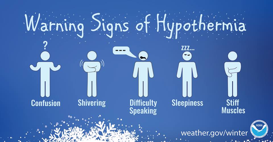
Hypothermia is a dangerously low body temperature and is the most common winter weather killer. When you hear of a hiker, climber, hunter or a stranded traveler perishing from cold weather exposure, hypothermia was the cause. Most people are surprised to learn that hypothermia deaths can occur with temperatures between 30 and 50 degrees. If you or your clothing are wet, then hypothermia becomes even more likely.

Warning signs of hypothermia include uncontrollable shivering, memory loss, disorientation, slurred speech and drowsiness. Immediate medical attention should be given to victims suspected of suffering from hypothermia. If no help is available, the victim should be warmed slowly with warm liquids along with dry clothing and blankets.

The National Weather Service will issue wind chill advisories and warnings when a deadly combination of wind and cold air threaten. A Wind Chill Warning will be issued for the following wind chill temperatures:

  • Mountains…minus 35 degrees Fahrenheit or colder.
  • Lower Elevations…minus 25 degrees Fahrenheit or colder.

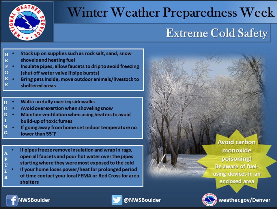
When cold weather threatens, follow these tips for survival:

  • Stay dry, wet clothing results in much faster heat loss from your body. Wear waterproof insulated boots.
  • Stay covered, wear mittens or gloves and wear a hat. At least half of your body heat is lost if your head is not covered.
  • Dress layered, trapped air between loose fitting clothing helps to insulate.
  • Stay informed, have a portable NOAA weather radio nearby to keep you up-to-date with the latest forecasts and warnings. Use wind chill temperatures to guide you in dressing properly for the outdoors. On very cold days, minimize your exposure to the outdoors if possible.

Winter Weather - Extreme Cold Safety

Winter Weather - Signs of Hypothermia

Wind Chill Chart

High winds a major threat in Colorado during the winter

Winter winds can not only make it miserable to be outside, they can also be dangerous.

As we often experience, high winds in Colorado can cause conditions to deteriorate rapidly.  They present a very real danger to life and property, especially when coupled with other winter conditions like snow.

Why does it seem like we get so much wind in the winter?  What causes this?  How can you prepare and protect yourself and your property?

In this third in a series on winter weather preparedness from the National Weather Service, ThorntonWeather.com helps you understand why we receive so much wind and how to prepare for it.

PUBLIC INFORMATION STATEMENT
NATIONAL WEATHER SERVICE BOULDER CO
ISSUED BY NATIONAL WEATHER SERVICE PUEBLO CO
600 AM MDT WED OCT 19 2022

…WIDESPREAD HIGH WINDS VISIT COLORADO DURING THE WINTER…

This week through October 22nd is Winter Weather Preparedness Week in Colorado.

The two main causes of high winds in Colorado during the cold season are the air pressure difference between strong low pressure and cold high pressure systems, and Chinook winds developing across the Front Range and other eastern mountain ranges.

Continue reading High winds a major threat in Colorado during the winter

Microburst winds cause damage in Thornton

High winds

The evening of June 5 had been relatively calm after a record-tying high temperature. Some high-based thunderstorms then began to move through and created gusty winds.  For some residents, those winds turned damaging.

What appears to have been a microburst (or multiple microbursts), brought fences, broke tree branches and for one Thornton family, toppled a 40 year old tree.  Watch the video below for the story from CBS4.

The winds did appear confined to relatively small areas, hitting hard when they did.  At ThorntonWeather.com, we saw some gusty winds (39mph) but nothing that would cause the type of damage seen by others.

The National Weather Service did report a 54mph gust at Denver International Airport and a 66mph gust at Buckley Air National Guard Base.

Did you suffer damage?  If you have pics, we’d love to see them!


National Weather Service releases summary of New Year’s Eve windstorm

A windstorm pummeled northeastern Colorado on New Year's Eve 2011.

Northeastern Colorado closed out 2011 with pummeling high winds on New Year’s Eve.  Wind gusts of tropical and hurricane storm strength slammed into the region causing damage and claiming one life.

In the Denver metro area gusts approaching 50mph were common while areas in the foothills and mountains to the west and on the plains to the northeast saw much higher speeds.  Here in Thornton we recorded a maximum gust of 44.9mph in the predawn hours.

Following is a summary of the event from the National Weather Service:

Post-Storm Summary of the New Year’s Eve Windstorm

A fast moving upper level storm system, along with a deep low pressure system over Nebraska and high pressure building over Utah, combined to create a powerful windstorm across Northeast and North Central Colorado on December 31st. The high wind event began in the mountains after midnight Friday night, and then spread across the plains early Saturday morning. The height of the windstorm on the plains occurred around mid day when numerous gusts between 60 and 80 mph were reported.

The strong winds produced damage to fences and some roofs, and also knocked down trees resulting in power outages to approximately 19,000 residents. Some trucks were also blown off the road, and 1 fatality occurred due to a flying tree limb on U.S. Highway 36 north of Boulder.

Visibilities over the northeast corner of the state were also reduced significantly by a combination of blowing dust and blowing snow.

The following is a list by county of maximum wind gusts associated with this powerful windstorm…

Location Maximum Wind Gust

Adams…
Bennett 60 MPH
Front Range Airport 60 MPH

Arapahoe…
Deer Trail 59 MPH
Centennial 55 MPH

Boulder…
1 W Lyons 101 MPH
4 NW Boulder 84 MPH
Boulder 81 MPH
NCAR Mesa Lab 79 MPH
North Longmont 75 MPH
Boulder Municipal Airport 59 MPH
2 NNW Louisville 58 MPH

Broomfield…
Rocky Mountain Regional Airport 58 MPH

Clear Creek…
Berthoud Pass 94 MPH

Denver…
Buckley AFB 64 MPH
Denver International Airport 59 MPH

Douglas…
Centennial Airport 55 MPH
10 SSE Castle Rock 52 MPH
Highlands Ranch 50 MPH

Elbert…
10 E Parker 67 MPH
Elizabeth 55 MPH

Grand…
Berthoud Pass 94 MPH
11 N Kremmling 80 MPH
9 S Fraser 80 MPH

Jefferson…
3 SSE Pinecliffe 111 MPH
3 S Golden 86 MPH
Highway 72 and 93 Junction 79 MPH
National Wind Technology Center 77 MPH
3 NNW Morrison 76 MPH
4 S Rocky Flats 73 MPH
2 E Golden 67 MPH
2 E Northeast Lakewood 64 MPH
2 ENE Lakewood 64 MPH
3 W Conifer 62 MPH
Wheat Ridge 55 MPH

Larimer…
4 E Loveland 73 MPH
Natural Fort Rest Area 71 MPH
5 NW Fort Collins 67 MPH
3 NE Loveland 67 MPH
Wellington 63 MPH
4 E Fort Collins 63 MPH
Virginia Dale 62 MPH
Fort Collins 57 MPH

Lincoln…
3 W Cedar Point 80 MPH
Limon Airport 74 MPH

Logan…
Sterling Airport 73 MPH
Sterling 70 MPH
Crook 65 MPH

Morgan…
Wiggins 61 MPH

Park…
Kenosha Pass 79 MPH
Fairplay 77 MPH
Wilkerson Pass 58 MPH

Phillips…
4 E Haxtun 70 MPH
Holyoke 63 MPH
8 S Holyoke 62 MPH

Summit…
7 S Frisco 126 MPH
9 E Dillon 90 MPH
7 SSW Frisco 86 MPH

Washington…
Akron 75 MPH
Woodrow 73 MPH
5 NW Woodlin School 67 MPH

Weld…
4 ENE Eaton 80 MPH
3 NNW Cornish 79 MPH
2 NNW New Raymer 77 MPH
10 NE Pawnee Buttes 74 MPH
Briggsdale 72 MPH
9 NNE Briggsdale 72 MPH
7 N Rockport 70 MPH
Greeley Airport 67 MPH
4 ENE Severance 63 MPH
Eaton 63 MPH
1 N Greeley 62 MPH
6 E Berthoud 62 MPH
2 W Keenesburg 58 MPH
Milliken 56 MPH

12/31/11 - Here is surface pressure analysis (light blue lines) and infrared satellite image at 12 PM MST near the height of the windstorm.  Note the large difference in pressure between the surface low pressure over southeast Nebraska and high pressure centered over southern Idaho, and the resulting tight gradient across Colorado.  This is a key feature in windstorms across the Front Range and High Plains. (NWS)
12/31/11 - Here is surface pressure analysis (light blue lines) and infrared satellite image at 12 PM MST near the height of the windstorm. Note the large difference in pressure between the surface low pressure over southeast Nebraska and high pressure centered over southern Idaho, and the resulting tight gradient across Colorado. This is a key feature in windstorms across the Front Range and High Plains. (NWS)
12/31/11 - A 6 hour model forecast of 700 mb winds (approximately 10,000 ft MSL) and surface pressure.  700 mb wind strength is noted by flags (50kts) plus barbs (10kts for full & 5kts for half).  Stronger downslope flow and large scale subsidence which occurred in this storm can bring these stronger winds aloft down to the surface. (NWS)
12/31/11 - A 6 hour model forecast of 700 mb winds (approximately 10,000 ft MSL) and surface pressure. 700 mb wind strength is noted by flags (50kts) plus barbs (10kts for full & 5kts for half). Stronger downslope flow and large scale subsidence which occurred in this storm can bring these stronger winds aloft down to the surface. (NWS)
12/31/11 - A surface plot of weather stations across the region during the windstorm.  This image was taken at 1 PM MST, when the maximum winds were spreading across the northeast plains of Colorado.  At this time, the strongest corridor of winds stretched from Sterling (gusting to 59 kts or 68 mph), to Akron (gusting to 63 kts or 72 mph) to Burlington (gusting to 66 kts or 76 mph). (NWS)
12/31/11 - A surface plot of weather stations across the region during the windstorm. This image was taken at 1 PM MST, when the maximum winds were spreading across the northeast plains of Colorado. At this time, the strongest corridor of winds stretched from Sterling (gusting to 59 kts or 68 mph), to Akron (gusting to 63 kts or 72 mph) to Burlington (gusting to 66 kts or 76 mph). (NWS)

Hurricane-force winds hit Colorado’s high country, foothills

Hurricane-force winds pounded the Colorado high country on Saturday, November 12, 2011.
Hurricane-force winds pounded the Colorado high country on Saturday, November 12, 2011. Click the image for a larger view.

Fed by a strong jet streak roaring above the Colorado Rocky Mountains, a mountain wave setup over the western half of the state yesterday.  Strong winds were the result and were combined with heavy snow in the central and northern mountains.

The incredibly strong winds that would be the equivalent of a Category 3 hurricane ripped through Colorado’s high country in the past 24 hours.  Many locations reported gusts in excess of 100mph downing power lines and trees and creating hazardous driving conditions.

The top wind gust reported by the National Weather Service was 115mph south of Frisco in Summit County.

Berthoud Pass saw a 113mph gust at the Mines Peak Summit (12,500 feet) with sustained winds to 86mph.  After sending that reading, the station’s anemometer (wind sensor) broke.

Other locations recording gusts near 100mph included Loveland Pass at 100mph and Kenosha Pass recorded 101mph.   Berthoud in Larimer County saw 99mph and the National Center for Atmospheric Research Mesa lab in Boulder recorded 90mph.

Here in Thornton we thankfully didn’t see winds nearly that fast however ours were notable.  We recorded a 38mph gust Saturday afternoon and a 47mph gust shortly after midnight Sunday morning.

High winds like these, while quite strong, are not entirely unusual.  Dangers from these powerful winds include power outages, flying debris, collapsed structures and the potential to overturn vehicles.  Learn more in our story, Winter weather preparedness: The threat of high winds in Colorado.

Below is a water vapor satellite showing the mountain waves as the moved across the southern part of Colorado.

Stay up to date with all the latest Colorado weather:

Water vapor satellite imagery shows the mountain waves that existed across much of southeastern Colorado and northeastern New Mexico around 19:45 UTC on 12 November 2011. (CIMSS)


Video captures stage collapse in powerful winds at Indiana State Fair

This video screen capture shows the stage at the Indianapolis State Fair as it collapsed. (YouTube / JSilas7)
This video screen capture shows the stage at the Indianapolis State Fair as it collapsed. Watch the video below. (YouTube / JSilas7)

Winds alone are not normally associated with the loss of life but a sad reminder of the dangers was seen at the Indianapolis State Fair on Saturday.  Powerful thunderstorm winds downed a stage killing five people and injuring dozens while officials appeared to ignore warnings of the impending danger.

The Natural Disasters Examiner wrote in a story on Monday that the warning signs for severe weather in central Indiana were readily apparent as early as two days before the storm.

The National Weather Service discussed the thunderstorm and high wind dangers in its Hazardous Weather Outlook multiple times.  A Severe Thunderstorm Watch was issued hours before and a Warning 10 minutes before.

Despite this, officials at the fair failed to make a timely decision to cancel the Sugarland concert.  When the winds, estimated at 50 to 70mph struck, it only took a matter of seconds for the stage’s rigging to collapse.  Five people died and more than 40 were injured due to their failure.

The tragedy should serve as a reminder to everyone to pay attention to changing weather.  Do not ignore weather watches and warnings, no matter what others are doing.  The life you save may be your own.

The video below captures the event with shocking clarity.  It may be disturbing for some so viewer discretion is advised.

Our hearts and prayers go out to all those affected by the tragedy.

Wind may have contributed to deadly Adams County plane crash

The tail of the airplane is about all that was left after a deadly plane crash in Adams County. Yesterday’s thunderstorms brought powerful winds and lightning to the Colorado Front Range and may have been part of the reason for a plane crash in Adams County.  The small plane crashed in a field near Thornton killing its pilot.

The single-engine Cessna 182, owned by Jewel Aviation of Marshfield, Wisconsin, went down in a field near 124th Avenue and Quebec Street.  The pilot is believed to have been killed instantly when the plane exploded on impact.

The flight had just taken off from Front Range Airport approximately 20 miles away from the crash site.  Witnesses described seeing the plane struggling to stay airborne as it approached the field surrounded by residential homes.

Resident Catherine Von Axelson told 9News, “All of a sudden, this great big gust of wind hit.  His wing just completely flipped up and he nosedived into the ground and the plane exploded.”

Dry thunderstorms were moving through the area at the time of the crash.  Lightning from the storms sparked fires in the foothills and injured two National Guard airmen at Buckley Air Force Base.

The crash reportedly occurred at 3:25pm.  At that same time, ThorntonWeather.com reported gusts approaching 35 mph less than two miles from the crash site.  The owner of the station said that the actual gusts were likely much higher but measurements from the wind instrument are inhibited by nearby trees.

Microbursts, powerful straight line winds, often accompany Colorado’s thunderstorms and present a particular hazard to aviation.  Soon after the crash Denver International Airport halted takeoffs and landings and the facility reported a gust of 72mph.

Batten down the hatches – here comes the wind again

Much of the western and northern Front Range will be under a High Wind Watch starting tonight.

The relative calm of recent days is about to be replaced with high winds not unlike what we saw last week.   Winds will increase tonight and continue through Wednesday east of the Continental Divide.  Areas west of I-25 to the Divide and in the north and central mountain areas will be under a High Wind Watch from late tonight through Wednesday night. 

Much like last week, the usual suspect areas west of I-25 are the places to watch.  Fort Collins, Boulder and the western suburbs of Denver are going to get the worst of the wind.  The Peak to Peak Highway, Highway 287 north of Fort Collins, the Boulder Turnpike west of Broomfield, and Highway 93 between Boulder and Golden are naturally going to be prime targets. 

Wind gusts in excess of 80 mph can be expected in these areas but as we saw last week, other parts of the metro area can receive their fair share of wind as well.  As usual, it is best to put away anything in your yards that could be become a missile and if you are driving in the high wind areas, particular along a north / south route, be prepared for extremely gusty conditions.

Get more local news and weather information on Examiner.com.
This article and many more are posted to the Denver Weather Examiner site.
Visit Examiner.com for more local Denver news and weather.

The good news is that the downslope winds will also bring warmer temperatures – not that you will want to be outside in the wind.  Wednesday we will be well above normal with temperatures in the mid 50’s and Thursday could reach the low 60’s.  There is a slight chance of snow Friday but that isn’t looking to amount to much.

Winter weather preparedness articles added to Weather Education

Please view the Winter Weather Preparedness series to ensure you are ready for the winter!

We recently published a series of articles from the National Weather Service as part of Colorado’s Winter Weather Preparedness Week.  We have now made those stories easier to find by adding them to the Weather Education menu on the left of every page. 

This series of articles is a ‘must read’ for anyone living or traveling in Colorado or any place else that receives severe winter weather.  Covering a wide range of related topics, these articles help ensure you are ready for the coming winter.  The articles cover the following topics:


Part 1 Winter travel safety
Part 2 Watches…warnings…and advisories
Part 3 High winds
Part 4 Wind chill temperatures and hypothermia
Part 5  Avalanche safety
Review  Winter Weather Preparedness Week review

November 9th – 15th – This week in Denver weather history

November 9th - 15th - This week in Denver weather history.

Plenty of snow and wind dominate a look back at the Denver weather calendar for this week in weather history – November 9th to the 15th. 

PUBLIC INFORMATION STATEMENT
NATIONAL WEATHER SERVICE DENVER CO
645 PM MST SAT NOV 08 2008

…THIS WEEK IN METRO DENVER WEATHER HISTORY…

8-9   IN 1897…WEST WINDS WERE SUSTAINED TO 45 MPH WITH GUSTS
        AS HIGH AS 50 MPH IN THE CITY.
      IN 1919…POST-FRONTAL HEAVY SNOWFALL TOTALED 8.4 INCHES OVER
        DOWNTOWN DENVER.  MOST OF THE SNOW…6.6 INCHES…FELL ON THE
        9TH.  NORTH WINDS WERE SUSTAINED TO 26 MPH WITH GUSTS TO
        30 MPH ON THE 8TH.
      IN 1950…A MAJOR WINTER STORM DUMPED 10.4 INCHES OF SNOW AT
        STAPLETON AIRPORT WITH THE MOST SNOW…7.8 INCHES…FALLING
        ON THE 8TH.  EAST WINDS GUSTED TO 31 MPH AT STAPLETON
        AIRPORT ON THE 8TH.  SNOWFALL TOTALED 8.2 INCHES IN
        DOWNTOWN DENVER.
      IN 1958…STRONG WINDS CAUSED SOME DAMAGE IN BOULDER.  WEST-
        NORTHWEST WINDS GUSTED TO 40 MPH AT STAPLETON AIRPORT ON
        THE 8TH.
      IN 1975…HEAVY SNOWFALL HIT METRO DENVER.  SNOWFALL AT
        STAPLETON INTERNATIONAL AIRPORT TOTALED 8.0 INCHES AND
        EAST WINDS GUSTED TO 21 MPH.  POWER OUTAGES CAUSED BY THE
        STORM AFFECTED OVER 10 THOUSAND PEOPLE IN METRO DENVER.  IN
        THE FOOTHILLS WEST OF DENVER…10 TO 15 INCHES OF SNOW FELL.
        THE STORM PRODUCED THE GREATEST 24-HOUR PRECIPITATION…1.29
        INCHES…EVER RECORDED DURING THE MONTH OF NOVEMBER IN THE
        CITY.
Continue reading November 9th – 15th – This week in Denver weather history