The weather during the month of November in Denver metro area can offer just about anything. While it is normally a quiet month, it can be prone to extremes.
November is Denver’s second snowiest month and major snowstorms are not entirely uncommon. However conditions can also be quite dry.
Temperatures during the month continue to cool as we get closer to winter and by the end of the month the low temperatures routinely dip to 20 degrees or below. At times it can in fact bring conditions more like what we see in January.
Following on colder and wetter than normal weather in previous months, Thornton’s May returned us to drier and warmer than normal conditions.
The month started out with a bit of a wintry blast of cold temperatures and snow. In fact, Denver even set an all-time May low temperature on the 2nd of the month.
The cold and snow that started the month were probably overall the most notable feature of the month. The rest of May was not particularly extraordinary in any aspect.
Denver’s average temperature for the month was 57.9 degrees. This was 0.8 degrees above average. Here in Thornton we were just slightly cooler with an average temperature of 57.6 degrees.
Thornton’s temperatures ranged from a high of 89.2 degrees on the 14th down to a low of 20.7 degrees on the morning of the 2nd. Denver saw a maximum temperature of 88 and a low of 19 degrees.
Official Denver temperature records for the month included:
DAILY RECORDS:
DATE TEMPERATURE TYPE OF RECORD OLD RECORD YEAR LAST SET
MAY 2ND 19 DEGREES RECORD LOW 22 DEGREES 1954
MAY 14TH 87 DEGREES TIED RECORD HIGH 87 DEGREES 1996
MONTHLY RECORDS:
DATE TEMPERATURE TYPE OF RECORD OLD RECORD YEAR LAST SET
MAY 2ND 19 DEGREES TIED RECORD LOW 19 DEGREES MAY 3RD 1907
In terms of precipitation, Denver recorded only 0.82 inches, far below the average for May of 2.12 inches. Here in Thornton Mother Nature was far more generous as we recorded 2.35 inches.
The snow that started the month totaled 4.3 inches in Thornton, 3.4 inches in Denver. Both were well above the May average of 1.1 inches snowfall.
Thornton recorded its hottest month of the past six years during July 2012.
For the second month in a row, Thornton saw extraordinarily warm temperatures in July. The month not only was the warmest July ever recorded by ThorntonWeather.com, it was the warmest month recorded since we began operation.
The average temperature for July 2012 was an astonishing 75.5 degrees. This was 1.8 degrees above Thornton’s average for July over the past six years, a significant increase.
Temperatures ranged from a high of 98.7 degrees on July 1 down to a low of 56.6 degrees on July 11.
In all we recorded 23 days with high temperatures at or above 90 degrees. We did however manage to escape the month without breaking the century mark.
In terms of precipitation Thornton didn’t fare too poorly. We recorded 1.92 inches of precipitation in our rain bucket. This was only 0.03” below the six year average of 1.95 inches.
June 2012 will go into the record books as the hottest June since record-keeping began in Denver in 1872.
You didn’t need a thermometer to know that June 2012 was extraordinarily hot. What is normally one of the most pleasant months in Thornton turned into a scorcher with high temperature records seemingly falling daily.
The first half of the month was unseasonably warm but that was only a warm-up (pun intended) for what would come during the latter half of the month.
Officially for Denver nine daily high temperature records were tied or broken. The first record fell on June 4th and then the records on the 9th, 17th, 18th, 22nd, 23rd, 24th, 25th and 26th followed suit.
The temperature at Denver International Airport hit 100 degrees or higher six times during the month – the most ever recorded in June. Five of those 100 degree days were consecutive from the 22nd to the 26th and all of those dates set records. On 17 of the 30 days of the month the temperature reached 90 degrees or higher.
In the end Denver saw an average monthly temperature of 75.0 degrees. This was an astonishing 7.6 degrees above normal and puts June 2012 in the books as the hottest on record.
Thornton, while not quite as warm as DIA, still saw an extraordinarily hot month. We recorded 16 days of 90 degree or higher temperatures, one shy of Denver.
From the time ThorntonWeather.com was founded in October 2006 until the start of June 2012, we had only twice before recorded temperatures of 100 degrees or higher. We doubled that tally in June alone as on four days we reached 100 degrees or higher.
A look at temperature records set in Denver during the month of June. Click for a larger image. (National Weather Service)
Thornton recorded an average monthly temperature of 73.9 degrees. This was 6.7 degrees above the average of the previous five Junes.
In terms of precipitation, Denver officially recorded 1.22 inches of precipitation which was 0.76 inches below normal. All of that was recorded on the 6th and 7th when thunderstorms rolled through the airport area.
Here in Thornton we didn’t benefit from the thunderstorms nearly as well. A mere 0.11 inch of precipitation fell into our rain bucket, far below the 1.44 average of the past six years.
CLIMATE REPORT
NATIONAL WEATHER SERVICE BOULDER, CO
649 AM MDT SUN JUL 1 2012
…JUNE 2012…HOTTEST JUNE ON RECORD…
June 2012 was the hottest June in Denver since weather records began back in 1872. The month got off to a warm start with above normal temperatures during the first 9 days of the month. Record maximum temperatures were set and tied on the 4th and 9th respectively. An upper level trough of low pressure which moved across the northern and central Rockies brought cooler temperatures to the region… Resulting in below normal temperatures on the 10th and 11th. Upper level high pressure then reestablished over the region bringing another stretch of above normal temperatures from the 12th through the 19th. Record high temperatures were set both on the 17th and 18th. An upper level trough of low pressure and associated cold front brought some relief to Colorado on the 20th. The high temperature on the 20th was a pleasant 76 degrees…which was eight degrees below normal. Much above normal temperatures returned to Denver the final 10 days of the month as a strong upper ridge of high pressure built over the desert southwest and migrated into the central plains states. A stretch of 5 consecutive 100 degree days occurred from the 22nd through the 26th. This was only the third time in Denver weather history in which this has happened. The other occurrences were July 4th-8th 1989 and July 19th-23rd 2005. In addition…each of the 5 days set new record high temperatures. The 105 degree readings on the 25th and 26th established a new all time record maximum temperature for the month of June and tied Denver’s all time annual record high temperature.
Temperatures:
The average temperature for the month was 75.0 degrees which was 7.6 degrees above normal. This makes June of 2012 the hottest June on record. There were 17 days in which the maximum temperature exceeded 90 degrees. This ties 2002 for the second most 90 degree days in June. June of 2006 still holds the record with nineteen 90 degree days. There were also six days in which the temperature reached the century mark. This is a new record for 100 degree days in the month of June. The old record was 3 days back in June of 1990. The coldest temperature on the month was 43 degrees which occurred on the morning of the 11th. Below is list of temperature records tied or broken during the month.
JUNE 2012 TEMPERATURE RECORDS:

MONTHLY RECORDS:

JUNE 2012 WAS HOTTEST ON RECORD (AVERAGE TEMPERATURE WAS 75.0 DEGREES)
PREVIOUS RECORD WAS JUNE 1994 (AVERAGE TEMPERATURE OF 73.5 DEGREES)

JUNE 22ND-26TH 5 CONSECUTIVE DAYS MAX TEMPERATURE REACHED 100 DEGREES
OTHER OCCURRENCES (JULY 4TH-8TH 1989)  (JULY 19TH-23RD 2005)

JUNE 25TH AND 26TH SET ALL TIME JUNE RECORD HIGH TEMPERATURE 105 DEGREES
(PREVIOUS RECORD 104 DEGREES IN 1994)

DAILY RECORDS:

 DATE      TEMPERATURE  TYPE OF RECORD   OLD RECORD   YEAR(S) SET
JUNE 4TH   94 DEGREES  NEW RECORD MAX    93 DEGREES   1946, 1977
                                                      1990, 2010

JUNE 9TH   95 DEGREES  TIED RECORD MAX   95 DEGREES   1922, 2002
JUNE 17TH  98 DEGREES  NEW RECORD MAX    97 DEGREES   2007
JUNE 18TH 100 DEGREES  NEW RECORD MAX    99 DEGREES   1936, 1990
JUNE 22ND 102 DEGREES  NEW RECORD MAX    98 DEGREES   1874
JUNE 23RD 104 DEGREES  NEW RECORD MAX   102 DEGREES   1954
JUNE 24TH 102 DEGREES  NEW RECORD MAX   100 DEGREES   2007
JUNE 25TH 105 DEGREES  NEW RECORD MAX   100 DEGREES   1991
JUNE 26TH 105 DEGREES  NEW RECORD MAX   104 DEGREES   1994
JUNE 26TH  71 DEGREES  NEW RECORD HI MIN 68 DEGREES   1936 PREVIOUS YEARS

PRECIPITATION.

PRECIPITATION FOR THE MONTH WAS 1.22 INCHES...WHICH IS 0.76 INCHES
BELOW THE NORMAL 0F 1.98 INCHES. ALL OF THIS PRECIPITATION FELL ON
THE 6TH AND 7TH WHEN STRONG TO SEVERE THUNDERSTORMS MOVED ACROSS
PORTIONS OF THE DENVER METRO AREA. THERE WERE 8 THUNDERSTORMS
OBSERVED AT DENVER INTERNATIONAL AIRPORT DURING THE MONTH. THERE
WERE NO DAYS WITH DENSE FOG WITH A VISIBILITY AT OR BELOW 1/4 MILE
DURING THE MONTH. THE PEAK WIND OF 67 MPH FROM A WESTERLY DIRECTION
OCCURRED ON THE 26TH.
...................................

...THE DENVER CO CLIMATE SUMMARY FOR THE MONTH OF JUNE 2012...

CLIMATE NORMAL PERIOD 1981 TO 2010
CLIMATE RECORD PERIOD 1872 TO 2012

WEATHER         OBSERVED          NORMAL  DEPART  LAST YEAR'S
                 VALUE   DATE(S)  VALUE   FROM    VALUE  DATE(S)
                                          NORMAL
................................................................
TEMPERATURE (F)
RECORD
 HIGH             105   06/26/2012
                        06/25/2012
 LOW               30   06/02/1951
HIGHEST           105R  06/26       104       1       96  06/29
                        06/25                             06/28
LOWEST             43   06/11        30      13       45  06/10
AVG. MAXIMUM     91.7              82.4     9.3     83.3
AVG. MINIMUM     58.4              52.3     6.1     53.0
MEAN             75.0              67.4     7.6     68.2
DAYS MAX >= 90     17               7.9     9.1        7
DAYS MAX <= 32      0               0.0     0.0        0
DAYS MIN <= 32      0               0.0     0.0        0
DAYS MIN <= 0       0               0.0     0.0        0

PRECIPITATION (INCHES)
RECORD
 MAXIMUM         4.96   1882
 MINIMUM            T   1890
TOTALS           1.22              1.98   -0.76     2.43
DAILY AVG.       0.04              0.07   -0.03     0.08
DAYS >= .01         2               8.4    -6.4        8
DAYS >= .10         2               4.6    -2.6        4
DAYS >= .50         2               1.4     0.6        2
DAYS >= 1.00        0               0.3    -0.3        1
GREATEST
 24 HR. TOTAL    0.69   06/06 TO 06/07           06/19 TO 06/20
                                                          06/30 TO 06/30
                                                          06/30 TO 06/30
SNOWFALL (INCHES)
RECORDS
 TOTAL            0.4   1919
TOTALS            0.0

DEGREE_DAYS
HEATING TOTAL       6                62     -56       26
 SINCE 7/1       5399              6058    -659     5707
COOLING TOTAL     314               133     181      126
 SINCE 1/1        365               155     210      135

FREEZE DATES
RECORD
 EARLIEST     09/08/1962
 LATEST       06/08/2007
EARLIEST                        10/07
LATEST                          05/05
.................................................

WIND (MPH)
AVERAGE WIND SPEED              12.2
RESULTANT WIND SPEED/DIRECTION   5/169
HIGHEST WIND SPEED/DIRECTION    52/240    DATE  06/02
HIGHEST GUST SPEED/DIRECTION    67/250    DATE  06/02

SKY COVER
POSSIBLE SUNSHINE (PERCENT)   MM
AVERAGE SKY COVER           0.50
NUMBER OF DAYS FAIR            8
NUMBER OF DAYS PC             21
NUMBER OF DAYS CLOUDY          1

AVERAGE RH (PERCENT)     33

WEATHER CONDITIONS. NUMBER OF DAYS WITH
THUNDERSTORM              8     MIXED PRECIP               0
HEAVY RAIN                1     RAIN                       2
LIGHT RAIN                5     FREEZING RAIN              0
LT FREEZING RAIN          0     HAIL                       1
HEAVY SNOW                0     SNOW                       0
LIGHT SNOW                0     SLEET                      0
FOG                       1     FOG W/VIS <= 1/4 MILE      0
HAZE                      3

-  INDICATES NEGATIVE NUMBERS.
R  INDICATES RECORD WAS SET OR TIED.
MM INDICATES DATA IS MISSING.
T  INDICATES TRACE AMOUNT.
The National Oceanic and Atmospheric Administration’s Climate Prediction Center (CPC) released updated outlooks for winter 2011 – 2012 indicating it could be a snowy one for the northern half of Colorado.
The original outlooks from the agency released previously offered a drier picture, primarily based on the influences of La Niña in the Pacific. Given however that the current event is relatively mild, its effects are limited, particularly this far inland.
For the meteorological winter from December 2011 to February 2012, NOAA places virtually all of Colorado in an area that has equal chance of well above, well below, or near-normal temperatures. However, the northern half of the state, including Denver, is given a 33% chance of experiencing above normal precipitation.
NOAA said:
The winter outlook for this winter favors above average temperatures across much of the South, from New Mexico across the Southeast to the Atlantic coast… and also favors below average temperatures across much of the Northern plain, the Northern Rockies, the Pacific Northwest, and a good part of the West as well as the southern half of Alaska.
With regards to precipitation, we see those areas most likely to experience below-average precipitation across the South– in particular Florida and Texas– with a better than even chance of being wetter than average across much of the North– particularly from the Ohio valley and the Northern Rockies and the Pacific Northwest.
Last year, Denver experienced second least snowiest snow season on record as the city only recorded 22.8 inches (21.2 inches in Thornton). This season the picture is much improved with 22.2 inches having been recorded so far – nearly as much as all of last season.
NOAA's updated Winter 2011 - 2012 outlook. Click the image for a larger view. (NOAA)
Strengthening La Niña conditions in the Pacific could lead to another dry winter on the Colorado Front Range according to the winter 2011 / 2012 outlook released by NOAA. However, as we well know, Mother Nature is never consistent and other factors could give us some help.
While temperatures in the Equatorial Pacific Ocean are indeed cooler than normal – and getting cooler – at this point they remain warmer than they were last year at this same time. This does help us hold out some hope that the winter won’t be as dry as last year.
It should also be noted that the effects of La Niña and El Niño in Colorado are much harder to predict and less consistent than in other places in the nation. Our location near the middle of the country with the monstrous Rocky Mountains adjacent to us oftentimes throws a wrench in the works.
U.S. dealt another La Niña winter but ‘wild card’ could trump it Devastating drought in Southern Plains likely to continue
NOAA's winter 2011 temperature outlook. Click the image for a larger view.
The Southern Plains should prepare for continued drier and warmer than average weather, while the Pacific Northwest is likely to be colder and wetter than average from December through February, according to the annual Winter Outlook released today by NOAA.
For the second winter in a row, La Niña will influence weather patterns across the country, but as usual, it’s not the only climate factor at play. The ‘wild card’ is the lesser-known and less predictable Arctic Oscillation that could produce dramatic short-term swings in temperatures this winter.
NOAA expects La Niña, which returned in August, to gradually strengthen and continue through the upcoming winter. It is associated with cooler than normal water temperatures in the tropical Pacific Ocean and influences weather throughout the world.
“The evolving La Niña will shape this winter,” said Mike Halpert, deputy director of NOAA’s Climate Prediction Center. “There is a wild card, though. The erratic Arctic Oscillation can generate strong shifts in the climate patterns that could overwhelm or amplify La Niña’s typical impacts.”
The Arctic Oscillation is always present and fluctuates between positive and negative phases. The negative phase of the Arctic Oscillation pushes cold air into the U.S. from Canada. The Arctic Oscillation went strongly negative at times the last two winters, causing outbreaks of cold and snowy conditions in the U.S. such as the “Snowmaggedon” storm of 2009. Strong Arctic Oscillation episodes typically last a few weeks and are difficult to predict more than one to two weeks in advance.
NOAA's winter 2011 precipitation outlook. Click the image for a larger view.
With La Niña in place Texas, Oklahoma, New Mexico and parts of surrounding states are unlikely to get enough rain to alleviate the ongoing drought. Texas, the epicenter of the drought, experienced its driest 12-month period on record from October 2010 through September 2011.
Stormy periods can occur anytime during the winter season. To improve the ability to predict and track winter storms, NOAA implemented a more accurate weather forecast model on Oct.18. Data gathered from the model will support local weather forecast office efforts to prepare for and protect the public from weather events. This service is helping the country to become a Weather-Ready Nation at a time when extreme weather is on the rise.
According to the U.S. Winter Outlook (December through February) odds tilt in favor of:
Pacific Northwest: colder and wetter than average. La Niña often results in below-average temperatures and increased mountain snow in the Pacific Northwest and western Montana during the winter months. This may set the stage for spring flooding in the Missouri River Basin;
California: colder than average and wetter than average conditions in northern California and drier than average conditions in southern California. All of the southern part of the nation are at risk of having above normal wildfire conditions starting this winter and lasting into the spring;
Northern Plains: colder and wetter than average. Spring flooding could be a concern in parts of this region;
Southern Plains and Gulf Coast States: warmer and drier than average. This will likely exacerbate drought conditions in these regions;
Florida and south Atlantic Coast: drier than average, with an equal chance for above-, near-, or below-normal temperatures. Above normal wildfire conditions;
Ohio and Tennessee Valleys: wetter than average with equal chances for above-, near-, or below-average temperatures. Potential for increased storminess and flooding;
Northeast and Mid-Atlantic: equal chances for above-, near-, or below-normal temperatures and precipitation. Winter weather for these regions is often driven not by La Niña but by the Arctic Oscillation. If enough cold air and moisture are in place, areas north of the Ohio Valley and into the Northeast could see above-average snow;
Great Lakes: colder and wetter than average;
Hawaii: above-average temperatures in the western islands with above normal precipitation during the winter. Some drought recovery is expected across the state with Kauai and Oahu having the best potential for full recovery.
Alaska: colder than average over the southern half of the state and the panhandle with below average precipitation in the interior eastern part of the state.
This seasonal outlook does not project where and when snowstorms may hit or provide total seasonal snowfall accumulations. Snow forecasts are dependent upon winter storms, which are generally not predictable more than a week in advance.
April marks a transition between winter and summer for most of the country but for Denver it is especially true as we can see a stunning variety of weather. The proverbial April showers are certainly a possibility for Denver.
Snow? Tornadoes? Thunderstorms? You bet – all can happen! For good measure throw in a chance for hail and even dust storms and April gives every type of weather condition you could like – or hate.
Temperatures into the 70s and even the 80s aren’t entirely unheard of during the month. Conversely, April is our third snowiest month so we certainly have the potential for plenty of the white stuff as well.
Not since the 1888 to 1889 snow season has Denver seen less snow this far into the snow season than this year.
Amid record-setting snowfall in northern Europe this winter and blizzards on the U.S. East Coast, one place that normally sees its fair share of snow has been left high and dry. The Mile High City is facing a snow drought of near record proportions having thus far experienced its worst snow season in 122 years.
Denver’s snow season is from July through June and through the end of December Denver has recorded a mere 4.8 inches of snow. The majority of that (3.3 inches) was received from a pre-New Year’s storm on December 30th. Here in Thornton we have fared a mere 0.1 inch more snow for a total of 4.9 inches.
On average the city sees 25.6 inches from July through December and the pitiful show so far gives the 2010 to 2011 season a 20.8 inch snow deficit to date. Only one other time in the 128 years that snow records have been kept in Denver has so little snow been recorded to this point in the season.
One has to look back to the 1888 to 1889 season to find a more dismal snow season. It was that season 122 years ago that 3.8 inches of snow had been recorded by the end of December. The next worst season up to December was two seasons later when 5.5 inches was recorded.
Despite the snowstorm that struck on March 23rd and 24th and the rain that fell beforehand, the National Weather Service says Denver's March precipitation was below normal.
According to the Denver / Boulder office of the National Weather Service, Denver’s March weather was warmer and drier than normal. The latest climate summary from the service would seem to contradict what Denver residents actually experienced, at least in terms of precipitation.
The report starts with a seemingly contradictory statement saying, “Denver’s March 2010 finished with below normal liquid moisture in spite of finishing above normal in the snowfall category.”
According to the report, Denver recorded 0.80 inch of precipitation, well below the normal of 1.28 inches. Most of that occurred in conjunction with the snowstorm on the 23rd of the month when the official measuring station at Denver International Airport (DIA) reported 0.61 inch of precipitation. By contrast, ThorntonWeather.com recorded 1.42 inches of precipitation from that storm alone and 1.90 inches for the month.
Overall for the season, Denver has recorded 58.8 inches of snow which is 7.5 inches above the average snowfall up to this point. Denver’s snow season runs from July through June and we average 61.7 inches over that period so for 2010 we are quickly approaching a ‘normal’ year.
The average temperature as recorded at DIA was 41.0 degrees which was 1.4 degrees above the normal of 39.6 degrees. Temperatures for the month ranged from a high of 82 degrees on the 30th down to a low of 13 degrees on the 20th. The 82 degree high temperature on the 30th broke the record for that date of 81 degrees set way back in 1879.
Controversy once again surrounds measurements in latest report
The March 2010 climate summary once again highlights the problem. Comparison of temperature records for DIA versus areas closer to historical monitoring locations continue to show discrepancies. Standing out even more are precipitation records that are curious at best, ridiculous at worst given the wet snowstorm that struck on the 23rd and 24th.
The Denver Weather Examiner is in the process of updating our previous investigation and will have an updated report soon. In the meantime, you may wish to look at the results of the investigation we conducted last year.
February comes and serves as a bit of a month of transition between winter and spring. Average temperatures start to climb and things are generally pretty quiet.
However, it is still winter and below freezing temperatures at night still remain the norm. February is not typically a snowy month – in fact only the 6th snowiest – with an average of 6.3 inches. In terms of severe weather, the month joins September and October as being the quietest for Denver.
As we say though, it is a month of transition and as such extremes can and have occurred in the past. From severe cold and snow to beautiful spring-like days we can see it all. Oftentimes the month can lull us into a false sense of spring when the snowiest month – March – has yet to come.
 The weather during the month of November in Denver metro area can offer just about anything. While it is normally a quiet month, it can be prone to extremes.
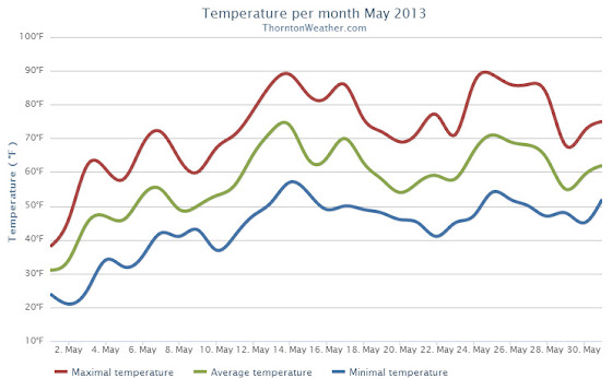


")


 April marks a transition between winter and summer for most of the country but for Denver it is especially true as we can see a stunning variety of weather. The proverbial April showers are certainly a possibility for Denver.

