Cars are buried under the heavy snow in Denver. Scroll down for a photo slideshow with more images. (Denver Public Library Digital Collection)
As Christmas approaches everyone reflects on the past and for longtime Denver residents that oftentimes means remembering one of the most significant winter storms in the Mile High City’s history – the Christmas Eve Blizzard of 1982. This major winter storm has become the one by which all others are compared not only due to its record-setting impact but also due to its timing being near Christmas.
As Christmas 1982 approached, forecasters were predicting a white Christmas several days beforehand but most were expecting a moderate snowfall of 6 inches. Two days before Christmas Eve though, the picture began to change. On the 22nd a Pacific cold front came ashore in California bringing severe rain, high surf and even hurricane force winds. As it moved east over higher terrain, it dumped 2 feet of snow in the Wasatch Mountains near Salt Lake City.
At about that same time, jet stream winds were forming a trough of low pressure over the southeastern plains of Colorado. The counterclockwise motion of the trough began to pull moist air into the state. Further east Kansas and Oklahoma experienced severe thunderstorms and even tornadoes. The winds set the stage for strong upslope conditions along the Front Range.
Scroll down to the view photo slideshow from this famous snowstorm
Do you remember the Christmas Eve Blizzard of ’82? Leave a comment below with your memories
Rain changed to snow on the plains and shortly before midnight on the 23rd, a full blown blizzard had developed. Denver woke to snow on the ground the morning of Christmas Eve but the storm was just getting started. Snowfall rates of 2 – 3 inches per hour were the norm during the day and winds screamed at 50mph causing wind chill temperatures to plummet to as low as -35 degrees. As conditions continued to deteriorate throughout the day, the gravity of the situation began to be realized. Continue reading Looking back at an unforgettable holiday – Denver’s Christmas Eve Blizzard of 1982→
Cars are buried under the heavy snow of the Holiday Blizzard of 2006. (ThorntonWeather.com)
Leading up to the Christmas holidays of 2006 the weather was nothing extraordinary in the Mile High City – until the 20th of the month. Temperatures at the middle of the month had entered into the 60’s and Denver residents were enjoying the warmth.
A few short days later, that all changed in a big way. A slow moving low pressure system coupled with upslope flow and copious amounts of moisture provided the perfect setup for a historical winter storm whose effects would be felt for months. Snow began falling on the morning of the 20th and by the early afternoon blizzard conditions began to set in and it was obvious we were in for one heck of a storm.
Scroll down to view images from this incredible storm
If you have pics from this event, please share them with us to add to the slideshow. You can email them to info@thorntonweather.com or share them with us on our Facebook page.
Businesses shut down early on the afternoon of the 20th in order to allow their employees extra time to make it home safe but by then a foot or more of snow had fallen across the Front Range. The governor called out the Colorado National Guard to help rescue stranded motorists who were in turn transported to area Red Cross shelters to wait out the storm. Continue reading Looking back: Denver’s Holiday Blizzard of 2006→
Winter winds can not only make it miserable to be outside, they can also be dangerous.
As we often experience, high winds in Colorado can cause conditions to deteriorate rapidly. They present a very real danger to life and property, especially when coupled with other winter conditions like snow.
Why does it seem like we get so much wind in the winter? What causes this? How can you prepare and protect yourself and your property?
In this third in a series on winter weather preparedness from the National Weather Service, ThorntonWeather.com helps you understand why we receive so much wind and how to prepare for it.
PUBLIC INFORMATION STATEMENT
NATIONAL WEATHER SERVICE BOULDER CO
ISSUED BY NATIONAL WEATHER SERVICE PUEBLO CO
600 AM MDT WED OCT 19 2022
…WIDESPREAD HIGH WINDS VISIT COLORADO DURING THE WINTER…
This week through October 22nd is Winter Weather Preparedness Week in Colorado.
The two main causes of high winds in Colorado during the cold season are the air pressure difference between strong low pressure and cold high pressure systems, and Chinook winds developing across the Front Range and other eastern mountain ranges.
Today’s message from the NWS highlights the importance of having a proper emergency kit in your vehicle and should the worst-case scenario occur where you get stuck, what you should do to survive.
PUBLIC INFORMATION STATEMENT
NATIONAL WEATHER SERVICE GRAND JUNCTION CO
601 AM MDT MON OCT 17 2022
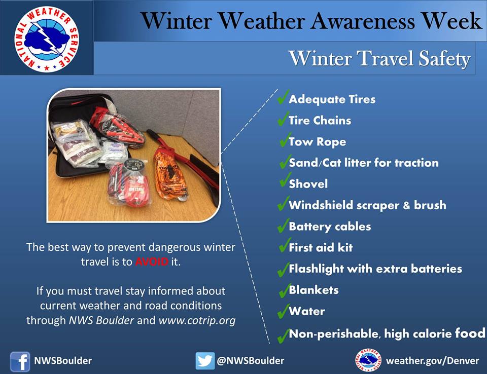
Winter Travel Safety
Winter Weather Preparedness Week continues through Saturday October 23rd. Preparedness is a big part of this campaign. Before winter weather arrives in earnest, it is highly recommended that you prepare your car or truck for winter travel. This includes a winter survival kit and good snow tires.
Before winter weather arrives in earnest, it is highly recommended that you prepare your car or truck for winter travel.
A well-equipped vehicle has adequate tires, tire chains, tow rope, sand or cat litter for traction, shovel, tool kit, windshield scraper and brush, battery cables, first aid kit, flashlight, extra batteries, blankets and/or sleeping bags, extra clothing, candles, waterproof matches, jug of water, high calorie packaged food for quick energy, and an empty can to melt snow for drinking.
And during winter weather events, the best way to prevent treacherous winter travel is to avoid it. This can be done by staying informed about current weather and road conditions as well as the latest weather forecasts. Information on road conditions in Colorado is available on the web at www.cotrip.org or from the toll free number 1-877-315-7623. When calling from anywhere in Colorado, dialing 511 will also access the Colorado road reports. Additionally, a free smartphone application, CDOT Mobile, is available.
If you should become stranded during a winter storm, stay with your vehicle and do not panic. If accompanied by others, take turns sleeping. Run the motor every hour for about ten minutes to maintain warmth, but keep windows open a little to prevent the buildup of carbon monoxide. Make sure the exhaust pipe is not blocked. Keep the car visible with brightly colored cloths tied to the side view mirrors, door handles, or external antenna. At night, turn on the dome light when running the engine. Exercise periodically by vigorously moving arms, legs, toes and fingers.
In the mountains, avalanches become a possibility in the winter, especially below steep slopes. Avalanches occasionally come down across roads, with little or no warning. However, avalanche control work is performed on many avalanche prone roads in Colorado, making the roads safer to travel. Caution is advised when traveling along avalanche prone roads, especially during and shortly after a heavy snowstorm, as well as during periods of rapid snowmelt.
Very strong downslope winds occur at times mainly along the front range of Colorado. These Chinook and Bora winds can have gusts exceeding 100 mph. Persons planning travel in lightweight or high-profile vehicles should avoid travel during these strong wind events especially on north-south oriented roads.
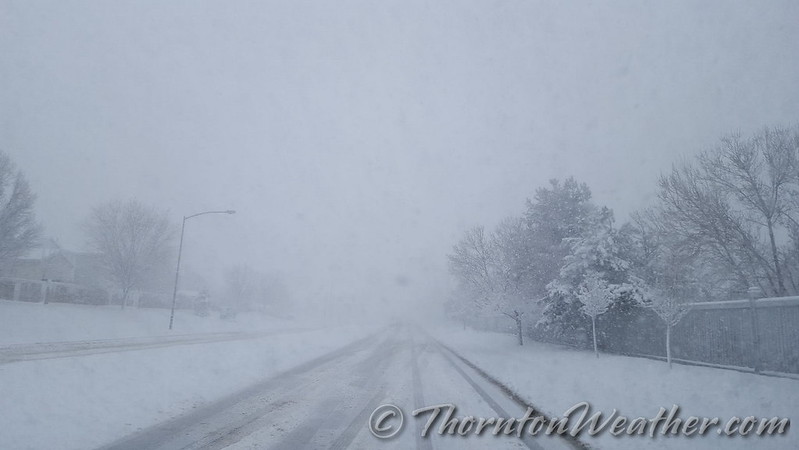
Roads which appear to be clear in the wintertime may actually be coated with a thin layer of ice, commonly known as black ice. This nearly invisible ice layer can cause you to rapidly lose control of your vehicle. Black ice is most common during the nighttime hours. If you detect black ice you should reduce your speed.
Please follow these winter travel safety recommendations which could save your life.
Don’t be caught off guard by winter weather! Remember the Christmas Eve Blizzard of 1982? Be prepared!
Winter weather in Colorado can be an inconvenience but more than that it can be deadly. Emergency preparedness for major winter storms – as well as for other types of severe weather – is an important part of living in a state where conditions can change wildly from one moment to the next.
To help raise awareness of the need to be prepared for these occasions, the week of October 16th to October 22nd has been proclaimed Winter Weather Preparedness Week in Colorado.
The National Weather Service will be issuing Public Information Statements each day this week to highlight the dangers of winter weather and how best to be prepared. ThorntonWeather.com will be posting these important messages here to help you be prepared. Please take the time to read and heed these messages – your life and the lives of your loved ones could depend on it.
Stay up to date with Thornton’s weather: ‘Like’ us on Facebook and follow us on Twitter.
From the National Weather Service:
PUBLIC INFORMATION STATEMENT
NATIONAL WEATHER SERVICE BOULDER CO
600 AM MDT SUN OCT 16 2022
..Winter Weather Preparedness Week in Colorado…
The week of October 16th through October 22nd is Winter Weather Preparedness Week in Colorado. This is an excellent time for all individuals, families, businesses, schools, and media outlets to review their winter storm preparedness plans. It is especially important for all new arrivals to the state to become familiar with the National Weather Service watch and warning definitions, as well as winter safety procedures.
Snow in Colorado is important to the farmers, the ski areas, and for filling up reservoirs. However, winter storms often bring heavy snow, bitter cold air, high winds, low visibilities and slick roads. This can lead to dangerous travel conditions and other life threatening situations such as avalanches and very frigid wind chill temperatures.
To help you prepare for these hazards this coming winter, the National Weather Service will issue statements throughout the week to discuss:
From rain to blizzard. This is time lapse video from our east-facing webcam showing Saturday AM to this morning. 48 hours in 2 minutes.
Thornton ended up with 20.6 inches. Our anemometer (wind sensor) froze up early yesterday morning so unfortunately no wind was recorded during the height of the event but I sure wasn’t going to climb on the roof to get it unstuck. 😉
The morning of March 23, 2016 saw the blizzard hit with full force. (ThorntonWeather.com)
It is hard to believe so much snow can fall over such a short period of time. Over just more than 12 hours Thornton received 21.7 inches – our biggest snowstorm since 2006. Our east facing webcam captured all the action from start to finish.
The video below starts at midnight on the 23rd with dry conditions. By about 2:00am rain falls but that quickly transitions to snow.
It is after daybreak that the storm gets started in earnest and the heavy snowfall almost entirely obscures the view at points. As is typical in Colorado, by mid-afternoon, we actually start to see some blue skies.
The video covers 19 hours in about 39 seconds. There are a few ‘hiccups’ in the video that you might notice. These were when we had brief power outages.
To say the storm that pounded the Colorado Front Range was a big one does not do it justice. In less than 24 hours Thornton would see blizzard conditions and our second heaviest snowfall of the previous 10 years.
Light rain began in the early morning hours but that soon transitioned to snow. The white stuff would continue to fall into the evening. Strong winds helped whip the snow and create blizzard conditions grinding the Colorado Front Range to a halt.
Thornton would tally 20.1 inches of snow, one of the heftier totals from the area.
The video below begins at midnight and runs through 7:00pm.
The United States has seen an extraordinary number of billion dollar disasters in 2011.
According to the National Climatic Data Center (NCDC), the U.S. has seen a record number of billion dollar disasters in 2011. Thus far this year the nation has seen 10 such disasters and with hurricane season far from over, it seems likely the number will grow.
The events range from the Groundhog Day Blizzard to Hurricane Irene’s recent devastating blow to the East Coast. In all, the disasters represent more than $35 billion in losses and that is no including Irene’s yet to be determined toll.
Below is the list and narrative for each disaster from the NCDC. For the latest disaster news, be sure to check out the Natural Disasters Examiner.
Hurricane Irene, August 20-29, 2011 While it will take several months to determine an accurate estimate of the damage from Hurricane Irene, there is no question it will rank as the 10th billion-dollar weather event of the year. This 10th U.S. billion-dollar disaster officially breaks the annual record dating back to 1980.
Upper Midwest Flooding, Summer, 2011 Melting of an above-average snow pack across the Northern Rocky Mountains combined with above-average precipitation caused the Missouri and Souris Rivers to swell beyond their banks across the Upper Midwest (MT, ND, SD, NE, IA, KS, MO). An estimated 11,000 people were forced to evacuate Minot, North Dakota due to the record high water level of the Souris River, where 4,000 homes were flooded. Numerous levees were breached along the Missouri River, flooding thousands of acres of farmland. Estimated losses exceed $2.0 billion as the event continues to unfold (as of 8/15). The flooding also stretched into the Canadian Prairies, where property and agriculture losses were expected to surpass $1.0 billion, at least 5 deaths.
Mississippi River flooding, Spring-Summer, 2011 Persistent rainfall (nearly 300 percent normal precipitation amounts in the Ohio Valley) combined with melting snowpack caused historical flooding along the Mississippi River and its tributaries. Estimated economic loss ranges from $2.0-4.0 billion; at least 2 deaths. Below are more detailed stats, which are preliminary, as the event continues to unfold (as of 8/15): $500 million to agriculture in Arkansas; $320 million in damage to Memphis, Tennessee; $800 million to agriculture in Mississippi; $317 million to agriculture and property in Missouri’s Birds Point-New Madrid Spillway; $80 million for the first 30 days of flood fighting efforts in Louisiana.
Southern Plains/Southwest Drought, Heatwave, & Wildfires, Spring-Summer, 2011 Drought, heatwave, and wildfires have created major impacts across the Texas, Oklahoma, New Mexico, Arizona, southern Kansas, and western Arkansas and Louisiana. In Texas and Oklahoma, respectively, 75% and 63% of range and pasture conditions were classified in ‘very poor’ condition as of mid-August. Wildfire fighting/suppression costs for the region are also ~$1 million / day with over 2,000 homes and structures lost. The total direct losses (as of August 15) to agriculture, cattle and structures are well over $5.0 billion; both direct and total economic losses will rise dramatically as the event continues.
Midwest/Southeast Tornadoes, May 22-27, 2011 Outbreak of tornadoes over central and southern states (MO, TX, OK, KS, AR, GA, TN, VA, KY, IN, IL, OH, WI, MN, PA) with an estimated 180 tornadoes and 177 deaths. Notably, an EF-5 tornado struck Joplin, MO resulting in at least 141 deaths, making it the deadliest single tornado to strike the U.S. since modern tornado record keeping began in 1950. Over $4.9 billion insured losses for event; total losses greater than $7.0 billion; 177 deaths.
Southeast/Ohio Valley/Midwest Tornadoes, April 25-30, 2011 Outbreak of tornadoes over central and southern states (AL, AR, LA, MS, GA, TN, VA, KY, IL, MO, OH, TX, OK) with an estimated 305 tornadoes and 327 deaths. Of those fatalities, 240 occurred in Alabama. The deadliest tornado of the outbreak, an EF-5, hit northern Alabama, killing 78 people. Several major metropolitan areas were directly impacted by strong tornadoes including Tuscaloosa, Birmingham, and Huntsville in Alabama and Chattanooga, Tennessee, causing the estimated damage costs to soar. Over $6.6 billion insured losses; total losses greater than $9.0 billion; 327 deaths.
Midwest/Southeast Tornadoes, April 14-16, 2011 Outbreak of tornadoes over central and southern states (OK, TX, AR, MS, AL, GA, NC, SC, VA, PA) with an estimated 160 tornadoes. Despite the large overall number of tornadoes, few were classified as intense, with just 14 EF-3, and no EF-4 or EF-5 tornadoes identified. Over $1.4 billion insured losses; total losses greater than $2.0 billion; 38 deaths [22 of which were in North Carolina].
Southeast/Midwest Tornadoes, April 8-11, 2011 Outbreak of tornadoes over central and southern states (NC, SC, TN, AL, TX, OK, KS, IA, WI) with an estimated 59 tornadoes. Over $1.5 billion insured losses; total losses greater than $2.2 billion; numerous injuries, 0 deaths.
Midwest/Southeast Tornadoes, April 4-5, 2011 Outbreak of tornadoes over central and southern states (KS, MO, IA, IL, WI, KY, GA, TN, NC, SC) with an estimated 46 tornadoes. Over $1.6 billion insured losses; total losses greater than $2.3 billion; 9 deaths.
Groundhog Day Blizzard, Jan 29-Feb 3, 2011 Large winter storm impacting many central, eastern and northeastern states. The city of Chicago was brought to a virtual standstill as between 1 and 2 feet of snow fell over the area. Insured losses greater than $1.1 billion; total losses greater than $2.0 billion; 36 deaths.
The March 2003 blizzard that buried Thornton in snow was ranked as the top weather event of the past 10 years. (ThorntonWeather.com)
There is a lot that can be said about the weather in Colorado but ‘boring’ is not usually a term associated with it. Anyone who has lived in the Centennial State for very long quickly experiences a weather-related event that will give them memories for a lifetime.
From major snowstorms and blizzards to tornadoes, wildfires, scorching heat and damaging hail storms Colorado weather can and does bring it all to the table. The Denver office of the National Weather Service has released a list of what local meteorologists rank as the top 10 weather events of the past 10 years.
For some it may be a blizzard that buried the Mile High City in a heavy blanket of snow and brought everything to a standstill. Others will remember the heavy smoke from fires burning in the mountains destroying hundreds of thousands of acres. The tragedy tornadoes bring to Colorado in terms of destruction and loss of life may be what others remember.
Over the past 10 years many memorable weather events have occurred that fully display the sheer variety of weather Colorado receives. A team of meteorologists serving Colorado analyzed these events and ranked them based on meteorological intensity and their human and economic impact.


")