Tag Archives: Colorado Weather

Winter travel safety – Ensure you and your vehicle are ready

Are you and your vehicle ready for the winter weather ahead?

Before hitting the road, Coloradans need to ensure that they and their vehicles are prepared should inclement weather strike.

ThorntonWeather.com presents the first in a series from the National Weather Service (NWS) as part of Winter Weather Preparedness Week has declared by Colorado’s Governor.  Check back throughout the week for more winter preparedness stories.

Today’s message from the NWS highlights the importance of having a proper emergency kit in your vehicle and should the worst-case scenario occur where you get stuck, what you should do to survive.

PUBLIC INFORMATION STATEMENT
NATIONAL WEATHER SERVICE GRAND JUNCTION CO
601 AM MDT MON OCT 17 2022

Winter Travel Safety

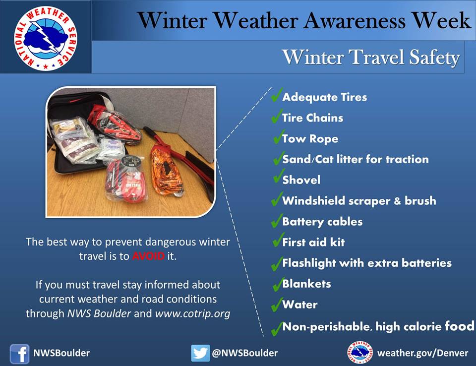
Winter Weather Preparedness Week continues through Saturday October 23rd. Preparedness is a big part of this campaign. Before winter weather arrives in earnest, it is highly recommended that you prepare your car or truck for winter travel. This includes a winter survival kit and good snow tires.

Before winter weather arrives in earnest, it is highly recommended that you prepare your car or truck for winter travel.

A well-equipped vehicle has adequate tires, tire chains, tow rope, sand or cat litter for traction, shovel, tool kit, windshield scraper and brush, battery cables, first aid kit, flashlight, extra batteries, blankets and/or sleeping bags, extra clothing, candles, waterproof matches, jug of water, high calorie packaged food for quick energy, and an empty can to melt snow for drinking.

And during winter weather events, the best way to prevent treacherous winter travel is to avoid it. This can be done by staying informed about current weather and road conditions as well as the latest weather forecasts. Information on road conditions in Colorado is available on the web at www.cotrip.org or from the toll free number 1-877-315-7623. When calling from anywhere in Colorado, dialing 511 will also access the Colorado road reports. Additionally, a free smartphone application, CDOT Mobile, is available.

If you should become stranded during a winter storm, stay with your vehicle and do not panic. If accompanied by others, take turns sleeping. Run the motor every hour for about ten minutes to maintain warmth, but keep windows open a little to prevent the buildup of carbon monoxide. Make sure the exhaust pipe is not blocked. Keep the car visible with brightly colored cloths tied to the side view mirrors, door handles, or external antenna. At night, turn on the dome light when running the engine. Exercise periodically by vigorously moving arms, legs, toes and fingers.

In the mountains, avalanches become a possibility in the winter, especially below steep slopes. Avalanches occasionally come down across roads, with little or no warning. However, avalanche control work is performed on many avalanche prone roads in Colorado, making the roads safer to travel. Caution is advised when traveling along avalanche prone roads, especially during and shortly after a heavy snowstorm, as well as during periods of rapid snowmelt.

Very strong downslope winds occur at times mainly along the front range of Colorado. These Chinook and Bora winds can have gusts exceeding 100 mph. Persons planning travel in lightweight or high-profile vehicles should avoid travel during these strong wind events especially on north-south oriented roads.

Roads which appear to be clear in the wintertime may actually be coated with a thin layer of ice, commonly known as black ice. This nearly invisible ice layer can cause you to rapidly lose control of your vehicle. Black ice is most common during the nighttime hours. If you detect black ice you should reduce your speed.

Please follow these winter travel safety recommendations which could save your life.


Winter Weather Awareness Week - Winter Travel Safety. (National Weather Service)
Winter Weather Awareness Week – Winter Travel Safety. (National Weather Service)


Colorado Winter Weather Preparedness Week introduction

Don't be caught off guard by winter weather! Remember the Christmas Eve Blizzard of 1982? Be prepared!
Don’t be caught off guard by winter weather! Remember the Christmas Eve Blizzard of 1982? Be prepared!

Winter weather in Colorado can be an inconvenience but more than that it can be deadly.  Emergency preparedness for major winter storms – as well as for other types of severe weather – is an important part of living in a state where conditions can change wildly from one moment to the next.

To help raise awareness of the need to be prepared for these occasions, the week of October 16th to October 22nd has been proclaimed Winter Weather Preparedness Week in Colorado.

The National Weather Service will be issuing Public Information Statements each day this week to highlight the dangers of winter weather and how best to be prepared.  ThorntonWeather.com will be posting these important messages here to help you be prepared.  Please take the time to read and heed these messages – your life and the lives of your loved ones could depend on it.

  • Stay up to date with Thornton’s weather: ‘Like’ us on Facebook and follow us on Twitter.

From the National Weather Service:

PUBLIC INFORMATION STATEMENT
NATIONAL WEATHER SERVICE BOULDER CO
600 AM MDT SUN OCT 16 2022

..Winter Weather Preparedness Week in Colorado…

The week of October 16th through October 22nd is Winter Weather Preparedness Week in Colorado. This is an excellent time for all individuals, families, businesses, schools, and media outlets to review their winter storm preparedness plans. It is especially important for all new arrivals to the state to become familiar with the National Weather Service watch and warning definitions, as well as winter safety procedures.

Snow in Colorado is important to the farmers, the ski areas, and for filling up reservoirs. However, winter storms often bring heavy snow, bitter cold air, high winds, low visibilities and slick roads. This can lead to dangerous travel conditions and other life threatening situations such as avalanches and very frigid wind chill temperatures.

To help you prepare for these hazards this coming winter, the National Weather Service will issue statements throughout the week to discuss:

Intro Winter Weather Preparedness Week
Part 1 Winter travel safety
Part 2 Watches…warnings…and advisories
Part 3 High winds
Part 4 Wind chill temperatures and hypothermia
Part 5 Avalanche safety
Review Winter Weather Preparedness Week review

A Preview of Thornton’s June Weather – The Severe Weather Month

Denver is historically Thornton's true severe weather month.

June is historically Denver’s severe weather month and severe thunderstorms, tornadoes and hail are notorious visitors to Denver and across eastern Colorado during the month.  In fact, over 40 percent of the tornadoes that occur in Colorado are observed in June and these are typically the most destructive of the year.  Severe thunderstorms have also caused major property damage across the Front Range during the month.

In just the last 25 years or so, there have been some particularly notable storms in June.  Tornadoes have struck the metro area including one that longtime Thornton residents will recall on June 3, 1981.  53 residents were injured, 25 homes were destroyed and 239 other structures were damaged.  Others tornadoes in the metro area include southeast Denver and Aurora on June 8, 1986 and east Denver on June 13, 1984.  Severe thunderstorms occurring on June 13, 1984 dumped large hail making it one of the worst and the second costliest storm in Denver history.  More recently, on June 20, 2001, a major hail storm moved across Denver International Airport dropping hailstones as big as two inches in diameter. Damage was extensive on and near the airport.

For complete details on what we can expect in June, click here to view our June weather preview.

A Preview of Denver’s April Weather – Something for Everyone

Do April showers bring May flowers?  Find out in our April 2009 weather preview!
Do April showers bring May flowers? Find out in our April 2009 weather preview!

April marks a transition between winter and summer for most of the country but for Denver it is especially true as we can see a stunning variety of weather. The proverbial April showers are certainly a possibility for Denver. Snow? Tornadoes? Thunderstorms? You bet – all can happen! For good measure throw in a chance for hail and even dust storms and April gives every type of weather condition you could like – or hate.

The good news is that sunshine and warmer temperatures are usually in abundance as the normal highs during the month move up from 57 degrees on the first to 65 degrees on the 30th. It is not unusual to have a number of days well into the 70’s and the low 80’s. We also see the normal lows move above freezing from 30 degrees at the start of the month to 39 degrees by the end. Temperature extremes can hit both ends of the spectrum with a record low of 2 degrees below zero on April 2, 1975 and a record high of 90 degrees on April 30, 1992.

Get all the details here in our complete April 2009 preview.

Denver blizzard moves out as the digging out begins

Thornton begins digging out from the March Blizzard of 2009.
Thornton begins digging out from the March Blizzard of 2009. This image is from our webcam as the storm really began in earnest just before noon.

The sun is already beginning to shine in the wake of Denver’s biggest snowstorm of the 2008 – 2009 winter season.  The storm was also Denver’s biggest since December 2007 when a series of storms dumped more than 30 inches on the city.  While the snow brings much-needed moisture to the parched Front Range, it was a stark contrast to the 70 degree temperatures of just a few days ago. 

Here is Thornton we received 11.4 inches of snow from the storm which increases our season total to 38.1 inches.  While yesterday’s snow helps, that is still barely half of what we average in a season so much more is needed if we want to make up lost ground.

Cold and wind were also part of the story.  Thornton’s high temperature yesterday was 35 degrees but that occurred before 11:00am.  Once the storm arrived, the mercury plummetted 15 degrees and we saw temperatures in the mid-teens.  Winds are what made the storm a blizzard and we had plenty of that with gusts to 33 mph.  The cold temperatures and wind coupled to give us wind chills in the low single digits and Thornton actually recorded a maximum wind chill of 1.3 degrees below zero.

If you haven’t seen it yet, check out these two Thornton weather stories from the blizzard:

For a complete recap on Denver’s March Blizzard of 2009, see our story on Examiner.com.

For all the details, read the rest of this story on our Denver Weather Examiner page. Examiner.com - Get inside Denver weather

Thornton’s March Blizzard 2009 – Time lapse videos

The March Blizzard of 2009 is winding down and it gives us a chance to look at all that happened in the last 36 hours or so.  One of the neat things to look at is the 24 hour time lapse video from yesterday.  Check out the video from our two webcams:

East Webcam Time Lapse – 3/26/09


West Webcam Time Lapse – 3/26/09

Denver and Thornton’s March 2009 climatological preview

Denver and Thornton's March 2009 climatological preview

March in Denver typically means frequent and rapid weather changes. The days grow longer and we start enjoying more sunshine and sometimes summer-like weather. However, on occasion arctic air masses can still force their way south into Colorado dropping temperatures quickly and markedly.

These changes are due to Marches “in between” status – elements during the month have much in common with winter and spring. In addition to arctic fronts, Pacific storms frequently move across Colorado from the west and warm moist air streams up from the Gulf of Mexico northeastward into the state. When these cold fronts collide with the warmer air masses the result can be some crazy weather.

Get all the details in our March 2009 climatological preview here.

December 14 – 20 – This week in Denver weather history

December 14 - 20 - This week in Denver weather history.

Our look back in Denver weather history for this week is punctuated by hurricane force winds – numerous times.  Some of these storms reached 120 mph, overturned semis, ripped roofs off and more.  Also notable is the blizzard we suffered through two years ago this week.

From the National Weather Service:

…THIS WEEK IN METRO DENVER WEATHER HISTORY…

2-17 

In 1939…more than 2 weeks of unseasonably warm weather made the month the 3rd warmest on record.  Seven daily temperature records were set…including the all time record high temperature for the month of 79 degrees on the 5th.  Daytime highs were balmy with 14 days in the 60’s and 70’s.  Low temperatures dipped to freezing or below on only 5 days.  The period was dry with only a trace of snow on the 12th.

3-15 

In 1972…a protracted cold spell held an icy grip on metro Denver when maximum temperatures never reached above freezing for 10 consecutive days from the 3rd through the 12th and minimum temperatures dipped below zero on eleven consecutive days from the 5th through the 15th. Daily low temperature records were set with 15 degrees below zero on the 5th…17 degrees below zero on the 6th… And 18 degrees below zero on the 10th.  Daily record low maximum readings were set with 3 degrees on the 6th and 6 degrees on the 9th.  The very cold temperatures were caused by 3 to 5 inches of snow cover and a Canadian air mass.

Continue reading December 14 – 20 – This week in Denver weather history

December 7 – 13 – This week in Denver weather history

December 7 - 13 - This week in Denver weather history.

Big wind, big snow, a heat wave and Arctic cold all highlight our look back at this week in Denver weather history.

From the National Weather Service:

2-17

IN 1939…MORE THAN 2 WEEKS OF UNSEASONABLY WARM WEATHER MADE THE MONTH THE 3RD WARMEST ON RECORD.  SEVEN DAILY TEMPERATURE RECORDS WERE SET…INCLUDING THE ALL TIME RECORD HIGH TEMPERATURE FOR THE MONTH OF 79 DEGREES ON THE 5TH.  DAYTIME HIGHS WERE BALMY WITH 14 DAYS IN THE 60`S AND 70`S.  LOW TEMPERATURES DIPPED TO FREEZING OR BELOW ON ONLY 5 DAYS.  THE PERIOD WAS DRY WITH ONLY A TRACE OF SNOW ON THE 12TH.

3-15

IN 1972…A PROTRACTED COLD SPELL HELD AN ICY GRIP ON METRO DENVER WHEN MAXIMUM TEMPERATURES NEVER REACHED ABOVE FREEZING FOR 10 CONSECUTIVE DAYS FROM THE 3RD THROUGH THE 12TH AND MINIMUM TEMPERATURES DIPPED BELOW ZERO ON ELEVEN CONSECUTIVE DAYS FROM THE 5TH THROUGH THE 15TH. DAILY LOW TEMPERATURE RECORDS WERE SET WITH 15 DEGREES BELOW ZERO ON THE 5TH…17 DEGREES BELOW ZERO ON THE 6TH… AND 18 DEGREES BELOW ZERO ON THE 10TH.  DAILY RECORD LOW MAXIMUM READINGS WERE SET WITH 3 DEGREES ON THE 6TH AND 6 DEGREES ON THE 9TH.  THE VERY COLD TEMPERATURES WERE CAUSED BY 3 TO 5 INCHES OF SNOW COVER AND A CANADIAN AIR MASS.

5-7

IN 1978…A MAJOR STORM DUMPED HEAVY SNOW ACROSS METRO DENVER. AT STAPLETON INTERNATIONAL AIRPORT…SNOWFALL TOTALED 8.5 INCHES…NORTHEAST WINDS GUSTED TO 46 MPH…AND TEMPERATURES PLUNGED FROM A HIGH OF 49 DEGREES ON THE 5TH TO A LOW OF ONLY 6 DEGREES ON THE 6TH.  MAXIMUM TEMPERATURE OF 6 DEGREES ON THE 7TH WAS A NEW DAILY RECORD LOW MAXIMUM READING.  MOST OF THE SNOW…6.7 INCHES…FELL ON THE 5TH.

Continue reading December 7 – 13 – This week in Denver weather history

November 16th – 22nd – This week in Denver weather history

This week in Denver weather history - November 16th to the 22nd.

Looking back into the Denver weather history books for this week, November 16th to the 22nd, we see a lot of the normal things we would expect to – lots of wind and snow.

 PUBLIC INFORMATION STATEMENT
NATIONAL WEATHER SERVICE DENVER CO
645 PM MST SAT NOV 15 2008
 
..THIS WEEK IN METRO DENVER WEATHER HISTORY…

14-18 IN 1964…THE FIRST MEASURABLE SNOWFALL OF THE SEASON
        TOTALED 6.0 INCHES AT STAPLETON INTERNATIONAL AIRPORT
        WHERE NORTHEAST WINDS GUSTED TO 32 MPH ON THE 14TH.
        MOST OF THE SNOW…4.2 INCHES…FELL ON THE 14TH.  THIS
        WAS THE ONLY MEASURABLE SNOW OF THE MONTH.
15-16 IN 1894…WINDS BEHIND AN APPARENT STRONG COLD FRONT WERE
        SUSTAINED TO 60 MPH WITH GUSTS TO 75 MPH ON THE 15TH.
        SNOWFALL TOTALED 2.6 INCHES IN THE CITY.  TEMPERATURES
        PLUNGED FROM A HIGH OF 72 DEGREES ON THE 15TH TO A LOW
        OF ONLY 5 DEGREES ON THE 16TH.  THE HIGH TEMPERATURE
        ON THE 16TH WAS 24 DEGREES…WHICH OCCURRED SHORTLY
        AFTER MIDNIGHT.
      IN 1996…AROUND A FOOT OF NEW SNOW FELL IN THE FOOTHILLS
        WEST OF DENVER WITH 3 TO 6 INCHES AT LOWER ELEVATIONS
        ACROSS METRO DENVER.  SOME OF THE SNOWFALL TOTALS
        INCLUDED:  15 INCHES AT GEORGETOWN…12 INCHES AT IDAHO
        SPRINGS…10 INCHES AT CHIEF HOSA…AND 9 INCHES IN COAL
        CREEK CANYON.  SNOWFALL TOTALED 2.9 INCHES AT THE SITE
        OF THE FORMER STAPLETON INTERNATIONAL AIRPORT.  NORTHEAST
        WINDS GUSTED TO 23 MPH AT DENVER INTERNATIONAL AIRPORT ON
        THE 16TH.
Continue reading November 16th – 22nd – This week in Denver weather history