Category Archives: Severe Weather

One Year Anniversary of Holly Tornado Marked Friday

On year anniversary of the Holly tornado.Friday marked the one year anniversary of the tornado that struck Holly, Colorado in Prowers County.  At 8:11pm on March 28, 2007, with no real warning, an EF-3 tornado with winds of 165mph touched down and quickly tore a path more than two miles long and four blocks wide.  162 of the 369 homes in Holly were either damaged or destroyed but most notably, Rosemary Puga died during the storm and Delores Burns died a month later due to the injuries she suffered.

Today Holly is rebuilding and showing the American spirit of survival that has been demonstrated so many times in our country’s history.  From the ashes of pain, suffering and destruction a new Holly is rising today but it serves as a reminder of the destructive power of Mother Nature.  Here in Colorado we can see the entire gamut of severe weather and while we talk about the weather every day, we should always remember that it is not us who is in control and lives can be lost. 

Please take a moment to say a prayer for Rosemary, Delores and all of the residents of Holly. 

NOAA: Increased Flood Risk, Minimal Drought

Yesterday NOAA released its spring drought and flood risk predictions and in it are some good and bad news for Colorado. 

Beware of the dangers of flooding!First, the good news.  With the extraordinary amount of snow the mountains have experienced this winter, the chances of drought are negligible for most of the state.  The southeastern corner of Colorado however could see some risk.

Second, the bad news.  With all that snow comes a risk of flooding.  The danger could be especially great if we experience a warmer than normal spring and the mountain runoff occurs too quickly.  Most of the state, with the exception of the northeast corner, runs above normal risks of flooding this spring.  Locations in the mountains of Colorado have 150 to 200 percent of average water contained in snowpack leading to a higher than normal flood potential.  Flooding is the number one weather killer in the country so everyone needs to be aware of the dangers this presents! 

For more information, please see NOAA’s report here.

2008 Spring Drought Outlook     2008 Spring Flood Danger Outlook

NWS Storm Spotter Training in March & April

Storm Spotter Training This WeekUpdated 3/21 @ 9:30am – ThorntonWeather.com attended the recent training in Westminster and found it to be very worthwhile.  Most of the topics covered related to severe thunderstorms, how to recognize the various types, the potential for tornadoes, and more.  If you are interested in attending one of these sessions, please follow the link below.  There are more sessions in the coming weeks in the north metro area.

3/17/08 @ 12:56pm – The National Weather Service will be conducting storm spotter training this Wednesday and Thursday at Front Range Community College.  The Colorado All-Season Spotter Team (CAST) is a volunteer spotter network which provides real-time weather information year round to forecasters at the National Weather Service in Boulder, Colorado.

These are great sessions for anyone wanting to learn more about the severe weather we experience in Colorado.  All training is free.  Topics include:

  • Basics of thunderstorm development
  • Fundamentals of storm structure
  • Identifying potential severe weather features
  • Information to report
  • How to report information
  • Basic severe weather safety
  • To learn more about the program, see here:  http://www.crh.noaa.gov/bou/awebphp/spotter.php

    To view more information on this week’s training as well as future dates, see here:  http://www.crh.noaa.gov/bou/?n=spot_training

    Cleanup Continues After 57 Die In Tornadoes

    Tornadoes hit the southThis past Tuesday saw over 40 tornadoes touch down across Tennessee, Arkansas, Missouri, Kentucky, Alabama and Mississippi.  The death toll from these storms currently stands at 57 making it one of the 15 worst tornado death tolls since 1950, and the nation’s deadliest swarm of tornadoes since 76 people were killed in Pennsylvania and Ohio on May 31, 1985. 

    It is currently believed that because February tornadoes are not all that common, simple human nature may have been the root reason for so many fatalities.  Simply put, people weren’t expecting them or believing the warnings that were issued well in advance.  From USA Today: 

    “Because February tornadoes are relatively rare, many residents didn’t respond quickly to warnings from weather forecasters because they didn’t believe the threat was serious until a storm was upon them. In fact, February tornadoes are “almost an annual event,” Brooks said. In 2007, there were three killer tornadoes in February — two in Florida and one in Louisiana — that killed a total of 22 people. During the most common months for tornadoes — March, April, May and June — fatalities typically are 15% lower and injuries are 22% lower because people expect such storms and prepare for them, said Dan Sutter, an economist at the University of Texas Pan American who has studied tornadoes for eight years.”

    This truly is a tragedy and one has to wonder how many of these deaths could have been avoided had residents simply heeded the warnings that were issued.  For more information, please see:

    USA Today – Cleanup continues after devastating tornadoes

    The Tennessean – Nashville newspaper’s special section about the storms

    Memphis Radar Image

    Memphis radar image from February 5, 2008

    Storm Chaser Convention Coming to Denver

    Storm Chaser Convention Coming to DenverFebruary 15th -17th Denver will play host to the 10th Annual National Storm Chaser Convention.  The event will be held at the Raddison Hotel at I-225 and Parker Road (3200 South Parker Road).  Most notably, the keynote speakers will be Dr. Josh Wurman and Sean Casey who appeared in the recently aired Discovery Channel special, Storm Chasers.  This is a great opportunity for weather enthusiasts to share storm stories, learn more about severe weather and storm chasing, see new weather gadgetry and hear from some of the experts in weather related fields. 

    To learn more, please visit the National Storm Chaser Convention website at:  http://chaserconvention.com

    More Snow on the Way!

    Snow on the way!After receiving a few inches of snow in the metro area on Christmas Day (3.6 in Thornton), another round is on the way and it has the potential to be pretty bad.  At 4:56am this morning, the National Weather Service issued a Winter Storm Watch for the entire Front Range. 

    It is pretty unusual for them to issue a warning this far in advance unless they are confident it is going to hit and hit pretty hard.  4 – 8 inches are currently predicted with the potential for locally heaver amounts.  With as cold as it has been and is expected to stay for the next few days, this could get ugly.  Please plan your travel accordingly and be safe out there!

    A few Christmas snowfall notes, from the National Weather Service: 

    It appears that there may be a new daily snowfall for Denver for Christmas Day. The data in the link below extends back to 1900.  The 2.4 inches recorded today at 6 AM will beat the 1.7 inches set in 1912.  After dusting off some old records here at the National Weather Service office we discovered that 6.2 inches of snowfall was recorded on December 25, 1894.   We also found that prior to 1905 snowfall was recorded from 8 PM to 8 PM. From Jan 1905 to May 1999 snowfall data was from midnight to midnight. Since May 1999, snowfall data has been recorded from 6 AM to 6 AM.  The snow in 1894 began around 8 PM on the 24th and ended  around 2 PM on the 25th. The data for December 25, 2007 will show 2.4 inches recorded at 6 AM.  The remainder of the snow that fell today will be reflected on the data for the December 26.  It will be for the period from 6 AM on the 25th to 6 AM on the 26th. So did we have a record or not? It all depends on how you interpret  the data.  No matter how you look at it, Christmas day 2007 will be memorable.  Click here to check the Christmas day statistics  for snowfall from 1900 to 2006.

    On a related note…  When you look at the measurements for snowfall that we make here at ThorntonWeather.com, those are typically total accumulations for the day we actually received the snow, up until 9:00pm or so.  The National Weather Service standard of 6:00am to 6:00am measurements is fine but are not what most folks expect.  As mentioned above, the 6:00am measurements from yesterday showed 2.4 inches of snow in Denver but obviously more than that fell throughout the day.  We feel that providing a total measurement for the day the snow actually feel is more in line with what folks expect and think of. 

    Lightning Detector Up and Running

    Lightning
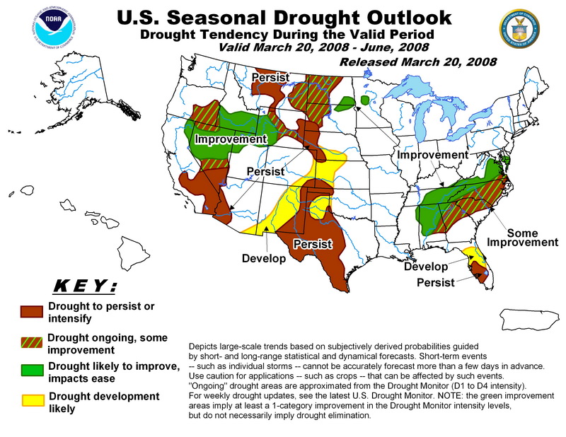
We are pleased to announce that ThorntonWeather.com’s lightning detector is now up and running!  This new system will allow us (and you) to monitor in real-time approaching storms and to more accurately gauge how severe a storm is and where it is headed.  Of course in the middle of winter there isn’t a lot to see on it but come spring, it will prove to be invaluable.  For more information on the system and how it works, please click here

    Lightning over the Colorado Mountains
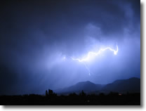
Colorado is ranked # 2 in lightning related deaths (1997 – 2006) so the danger this presents to life and property is very significant for us.  It is interesting to note though that Colorado ranks only 31st in the number of cloud to ground strikes over that same period.  This highlights the fact that, quite frankly, folks here in Colorado are ignorant about the dangers lightning presents and they simply do not take proper steps to protect themselves. For this reason, we have created a Lightning Education Center with more information about how you can protect yourself.  Click here to visit it.

    Some interesting facts about lightning:

    • – If you can see it or hear it, lightning can hit you. Find shelter now.
    • – Lightning is the number two weather killer in the United States (behind floods).
    • – Lightning kills about 60 people in the U.S. each year and inflicts severe life-long debilitating injuries on at least a 1,000 people a year.
    • – Every 5 seconds between flash and boom is a mile’s distance from you.
    • – Under ideal conditions, lightning’s thunder can be heard 12 miles away.
    • – Lightning is really no wider than a few inches.
    • – “Bolts from the Blue” – These lightning flashes have been documented to travel more than 25 miles away from the thunderstorm cloud.  Clear skies above you are no indication of how dangerous a nearby storm is!