Category Archives: Severe Weather

Windsor Tornado – Amazing Photo and Video

Some pretty amazing video and photos of the Windsor tornado came to my attention.

First up are two photos captured by a fellow weather enthusiast’s webcam.  Ryan of MyWindsorWeather.com captured the tornado as it passed about 2 miles to the east of his home.  Absolutely amazing.

MyWindsorWeather.com Webcam Capture #1 MyWindsorWeather.com Webcam Capture #2

Second, raw video from the 9News camera crew that captured the tornado.  Again, absolutely amazing.

Weld County Tornadoes Kill 1, Dozens Injured

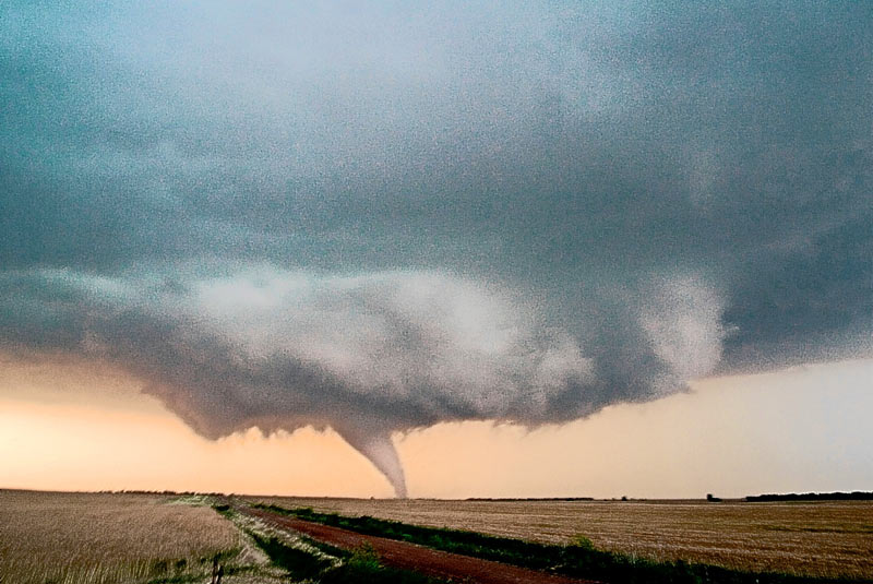
Thursday saw the largest outbreak of tornadoes in Colorado that we have seen in years strike the town of Windsor, destroying homes and businesses, tossing cars and semi-trucks like toys and killing one man.

Windsor tornado radar image.At about 11:20am ThorntonWeather.com radar began to pick up rotation in the skies just south and west of Greeley. Within minutes, we were tracking what was to be this deadly and damaging tornado and at 11:50am radar (image at left) showed the twister virtually on top of Windsor. The National Weather Service is evaluating damage from the storm but early estimates place it as an EF-2 or EF-3 on the Enhanced Fujita Scale which would have generated wind speeds between 111mph and 165mph.

Image of tornado courtesy 9News.
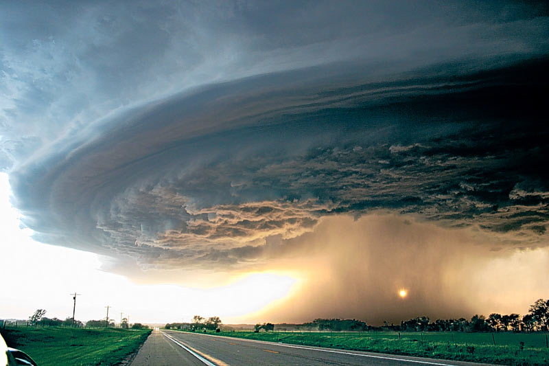
The tornado that struck Windsor was a wedge tornado, a type we don’t normally see here in Colorado. These are the largest and deadliest of all tornadoes because of their sheer size and ferocity and are like those that are common in Oklahoma.  This twister appears to have been on the ground for more than 30 minutes, was up to ½ mile wide and traveled 35 miles on the ground. In our state we usually see the well defined, thin “rope” tornadoes which while damaging, typically don’t last as long and are not near as big.

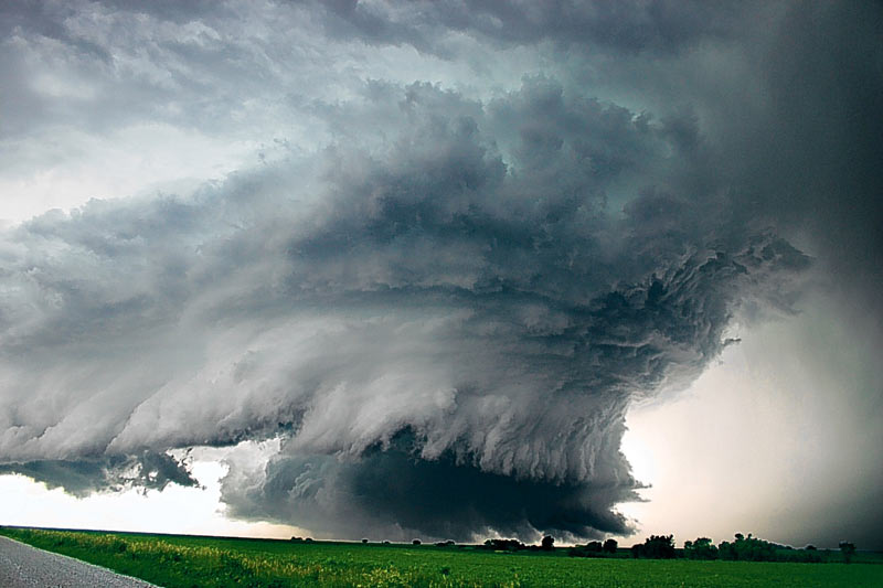
The Windsor tornado was but one of what were multiple tornadoes to strike north central Colorado Thursday. Some news outlets were reporting at one time that as many as eight possible twisters however we caution readers to take those numbers with a grain of salt. More often than not, the initial numbers are inaccurate as they reflect multiple reports of the same storm, simply as seen from a different location. The National Weather Service does the final determination and it would not be surprising to see that yesterday there were two or three twisters.

These tornadoes continue this year’s trend of increased tornado activity. As we previously reported, 2008 thus far ranks as the deadliest year for tornado-related deaths since 1998 and the severe weather season is not even half way over.

If you haven’t already, you may wish to read our article, “Severe Weather 101 – Tornadoes” which has some very important safety information about what to do when tornadoes strike.

Tornado Watch Issued. Hail and tornado reported north of Denver.

Windsor tornadoUPDATE, 1:13pm – Severe damage appears to have been caused by the first tornado to strike today. The Greeley Tribune is reporting one possible tornado death near the missile silo park near Colo. 257 near 10th Street in west Greeley. Reports are that old town Windsor has been heavily damaged.

UPDATE, 12:38pm – At 12:23pm law enforcement reported a tornado 4 miles west of Dacono (24 miles north of Denver). Storm is moving at 33mph. A Tornado Warning is active for the immediate area including Niwot, Dacono and Longmont.

Thursday, May 22nd, 2008 12:25pm MDT

The National Weather Service has issued a Tornado Watch effective until 8:00pm tonight for much of the central plains including the Denver metro area. Visual and radar indications show great potential for severe thunderstorms, hail and tornadoes in the area under the watch.

Radar image of tornado north of DenverAt 11:30am radar showed a tornado touching down three miles east of Milliken (about 45 miles north of Denver). The radar image at the right shows the cell in its early stages with a tornado signature. Reports indicate that there have been no injuries but officials have closed Highway 85 at Highway 60 after two semi-trailers were blown over in that area. Power is reported out in Greeley.

All readers should be reminded that a Tornado Watch is issued by the Storm Prediction Center in Norman, Oklahoma as a precautionary alert when conditions are favorable for the development of tornadoes in the specific area. You may wish to familiarize yourself by reading our Severe Weather 101 – Tornadoes article.

Please stay tuned to area media outlets for more information as this afternoon’s weather develops.

Storms on the Horizon – Celebrity Stormchasers Nearby

A storm front on the Colorado plains.After three consecutive days with temperatures over 85, change is in the air. Low pressure is intensifying over the foothills this afternoon and as a result the chance of thunderstorms is on the increase.

East of a line from Greeley to Byers will be where the greatest threat for severe storms will be. Large hail, damaging winds and tornadoes are a distinct possibility. Closer to the foothills and the metro area, late afternoon and evening will bring gusty winds and a chance for small hail. Scattered showers are possible through midnight.

The slow moving low will help keep temperatures down near normal for the foreseeable future after today however they also will provide for a chance of thunderstorms each day. Some of these storms may become severe although telling where and how widespread this activity will be is difficult. Certainly the northeastern plains have the greatest chance to see some excitement.

A number of advisories are in place at the current time. The southeastern part of the state is under Fire Weather Watches as things are tinder dry. In the mountains, much of the state west of the Continental Divide is under Flood Advisories. The recent warm temperatures have spurred fears of faster than normal snow melt and many rivers and streams are expected to reach flood stage.

This time of year just about anything can be expected. Keep an eye on the skies – especially if you are going to be outdoors for the upcoming holiday weekend.

StormChasersFor those that have seen the Discovery Channel’s StormChasers TV series, you may find it interesting to know that I have just learned that the StormChaser team is currently in Fort Morgan at this very moment.  As mentioned above, severe storms are likely over the northeastern plains this afternoon and evening and they apparently are there expecting the same and hoping to get some good data.  For those that haven’t seen this series, it is a MUST SEE for anyone interesting in severe weather or storm chasing!

Vehicles and Tornadoes – A Deadly Mix

A truck displays the damage a tornado can do to a vehicle.This past weekend a deadly spate of tornadoes struck Oklahoma and Missouri, killing at least 22 people. More than a third of those died in cars despite the fact that vehicles are one of the worst possible places to be when a twister strikes.

“It’s like taking a handful of Matchbox cars and rolling them across the kitchen floor,” said Sgt. Dan Bracker of the Missouri State Highway Patrol, surveying the damage in and around Seneca, near the Oklahoma line, the hardest hit area. “This is devastating.”

Experts warn that just about any place is better than a vehicle. In the extreme situation that you simply cannot get away from a tornado or find more appropriate shelter, abandon your vehicle immediately. Lie down in a ditch or culvert and cover your head. This isn’t a particularly good option, but it is safer than remaining in a vehicle.

If you haven’t already, you may wish to read our “Severe Weather 101 – Tornadoes” for more information.

Click here for a related news story.

Top 10 Lightning Myths & Facts

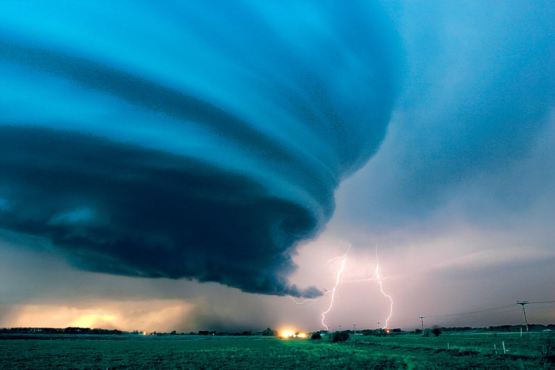
Lightning is the number two weather killer in the United States (behind floods). Here is Colorado we seem to be particularly blind to the dangers the phenomenom presents as we are ranked #2 in the U.S. for lightning related deaths. Over the years, a number of myths have developed about severe weather safety and lightning in particular. Here’s a few that you may want to keep in mind: Continue reading Top 10 Lightning Myths & Facts

Hail and Possible Tornado on Eastern Plains

Much of the eastern plains found itself under a Tornado Watch late Wednesday afternoon as a number of thunderstorms moved through the area. At about 5:00pm radar indicated a possible tornado 22 miles northwest of Burlington. Being a rural area, this has not been confirmed yet however storm spotters have reported hail up to 1.5 inches in diameter from the storm cell. Further south at about the same time, radar detected a storm with some serious rotation about 27 miles northeast of Lamar. One inch hail was recorded in the area but no tornadoes. Below are radar captures of the two cells at their prime.

These storms have moved east into Kansas at this time however the area remains under a Tornado Watch until 9:00pm. This serves to highlight that this is the severe weather season and while these particular storms were a good ways from the metro area, everyone needs to be prepared.

Colorado Storm Chasers – Start Your Engines!

Storm Chasers - Get Ready to RollIt looks like Wednesday will bring Colorado storm chasers their first chance to hit the road! A dryline is expected to develop and move eastward across the plains, east of Watkins. As this happens the chance for severe thunderstorms along and east of this line will be pretty good, possibly opening the door for large hail and tornadoes. The northeast corner of the state could be interesting to watch tomorrow.

Closer to home along the Front Range, a Red Flag Warning is in effect for Wednesday for most of the central part of the state. This low humidity and the winds are making things tinder dry so please, be very careful.

Never been on a storm chase? Here’s a sample:

Red Flag Warning In Effect For Wednesday

Fire Weather Watch IssuedHopefully this will get everyone’s attention. The fire danger continues to be high due to very low humidity and steady winds that are drying everything out. After spending Saturday and Sunday under a Red Flag Warning, the National Weather Service has issued another for Wednesday. PLEASE be careful out there.

RED FLAG WARNING NATIONAL
WEATHER SERVICE DENVER CO
347 PM MDT TUE APR 22 2008

…RED FLAG WARNING IN EFFECT FROM 10 AM TO 9 PM MDT WEDNESDAY…

THE NATIONAL WEATHER SERVICE IN DENVER HAS ISSUED A RED FLAG WARNING…WHICH IS IN EFFECT FROM 10 AM TO 9 PM MDT WEDNESDAY. THE FIRE WEATHER WATCH IS NO LONGER IN EFFECT.

DRY FUELS…ABOVE NORMAL TEMPERATURES…SOUTHWEST WINDS GUSTING TO BETWEEN 25 AND 40 MPH…AND MINIMUM RELATIVE HUMIDITY VALUES LESS THAN 15 PERCENT ARE STILL ANTICIPATED OVER THE FRONT RANGE FOOTHILLS AND ADJACENT PLAINS ON WEDNESDAY. CRITICAL FIRE WEATHER
CONDITIONS ARE EXPECTED TO DEVELOP BY LATE WEDNESDAY MORNING AND LAST THROUGH WEDNESDAY EVENING. THE RED FLAG WARNING COVERS THE FRONT RANGE FOOTHILLS…THE URBAN CORRIDOR FROM THE WYOMING BORDER TO THE PALMER DIVIDE AND THE COUNTIES OF WELD…MORGAN…
ARAPAHOE…ADAMS AND PARK. FIRE WEATHER CONDITIONS SHOULD IMPROVE LATER WEDNESDAY NIGHT AS WIND SPEEDS GRADUALLY DECREASE AND RELATIVE HUMIDITIES RISE.

A RED FLAG WARNING MEANS THAT CRITICAL FIRE WEATHER CONDITIONS ARE EITHER OCCURRING OR IMMINENT. PLEASE ADVISE THE APPROPRIATE OFFICIALS AND FIRE CREWS IN THE FIELD OF THIS RED FLAG WARNING.

Adventures in Tornado Alley: The Storm Chasers

Adventures in Tornado AlleyI just read about this new book Adventures in Tornado Alley: The Storm Chasers.  Most notably I saw some of the pictures in the book – absolutely incredible.  See below.  From Amazon’s description: 

The destructive power of nature has always been a source of fear and fascination, and never more so than now, when climate change and extreme weather conditions are constantly in the news. Across the central United States, the infamous storms of Tornado Alley are fueled by the collision of cold fronts from Canada and warm fronts from the Gulf of Mexico. People have been chasing these storms for decades in pursuit of thrilling experiences, but now a new generation of storm chasers is combining scientific knowledge with powerful images.

This book follows Mike Hollingshead and Eric Nguyen on seventeen chases through Colorado, Iowa, Kansas, Nebraska, New Mexico, Oklahoma, and South Dakota, illustrating the unfolding events with sequential shots and a running commentary by the chasers themselves. These spectacular storm portfolios are expanded with special features on weather phenomena like hail and mammatus clouds plus insights into forecasting and research. 340 color illustrations.

Definitely looks like a good one to check out!  You can find it here on Amazon.com

 Bolts from the blue  Independence Day II  Touchdown  Heaven’s Hammer