Ah yes, the changing of the seasons is here and that means our weather conditions go from one extreme to the next. Following a dry, warm week, Mother Nature brought snow to Colorado’s high country Friday night into Saturday leading to the closure of the highest, continues road in North America.
Rocky Mountain National Park reported dangerous conditions near the top of the Trail Ridge Road resulting in its temporary closure at Rainbow Curve on the east side and Milner Pass on the west side. Also closed was Old Fall River Road. Video from Trail Ridge showed a wintry scene looking like the Arctic tundra.
The agency said this was not the seasonal closure – yet.
Mother Nature played a somewhat cruel trick on the Colorado Front Range. The week started with mild temperatures and a definite feeling of spring in the air. She closed out the week with a significant snowstorm and plenty of cold.
The long-expected storm arrived on the evening of Friday the 15th with rain. Overnight into the early morning of the 16th, the rain continued, heavy at times. In the early morning hours, as temperatures dropped, the rain changed to snow and would continue virtually non-stop through the morning of the 17th.
Thornton’s snowfall totals were certainly at the lower end of what was reported in the Denver metro area. We saw 7.3 inches, much of which melted as fast as it fell. Other locations not far to the west and south were pushing a foot and locations in the foothills and Palmer Divide saw nearly two feet.
The time lapse video begins at midnight on the morning of the 16th and continues through noon on the 17th.
Washington (dpa)- More than 50 million people are bracing for a major winter storm predicted to hit the eastern US Friday that could bring large amounts of snow and heavy wind to the region. The National Weather Service has issued a blizzard watch in effect from Friday afternoon to Saturday night in Washington due to the… Continue reading Major winter storm forecast to hit eastern US over weekend→
As Christmas gets closer everyone always wonders if we are going to get the proverbial white Christmas. Unfortunately, if you look at Denver and Thornton weather history, the chances aren’t all that good but it also depends on what you define as a white Christmas.
If to you a white Christmas means having actual snowfall on Christmas Day the chances aren’t that good. But, if simply having snow on the ground suffices, the chances improve considerably.
The past week or so has brought quite a variety of weather, most notably seven straight days of precipitation. On Saturday we saw a continuation of the rain which changed to snow overnight, an event captured by one of our webcams.
Over the seven days, Thornton recorded a whopping 4.34 inches of liquid precipitation. Most of that fell as rain but 5.1 inches of snow provided some of that as well.
The video below shows the period from 3:00pm on Saturday, May 9 through 5:00pm on Sunday, May 10 compressed to about 53 seconds. It starts with rain which soon transitions to snow as the evening arrives. The snow continues into the following morning and then skies begin to clear and the snow quickly melts.
For many, the holiday season isn’t complete without a chill in the air and snow on the ground. Here in Denver we historically enjoy a better chance of experiencing the proverbial white Christmas than many places in the nation.
However, how the Mile High City fares in experiencing a white Christmas does depend on your definition of one.
If it means having actual snowfall on Christmas Day the chances aren’t that good. But, if simply having snow on the ground suffices, the chances improve considerably.
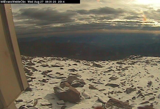
August 27, 2014 – Dawn reveals fresh snow on top of Mount Evans. (DU)
Snow at the Centennial State’s elevations can occur any time of year and last night Mother Nature delivered a white reminder that fall and winter are not far behind.
On Monday, the Colorado Department of Transportation closed the road to the top of Mount Evans due to the potential for snowfall. That potential was realized overnight last night as the observatory webcam this morning showed a couple of inches of snow on the ground.
This morning CDOT’s website reports the road is, “Closed from Summit Lake to top of Mount Evans due to adverse conditions. There is no estimated time of opening.”
The highest paved road in North America, the road to the summit of Mount Evans usually remains open until the first weekend of October when conditions prevent it from being maintained. It doesn’t reopen until the Friday before Memorial Day.
Other areas of the high country saw light doses of snow last night.
At 8:20pm last night the National Weather Service reported that 13,495 foot high Berthoud Pass was reporting 34 degrees. Moderate snow was falling and visibility had been reduced to 1/2 mile.
Snowfall above timberline will be possible tonight with potential accumulations of 1 to 2 inches in some locations.
Stay up to date with the dynamic weather: Be sure to ‘like’ us on Facebook, follow us on Twitter and add us to your Google+ circles.
May 10, 2003 – Heavy, wet snow weighed down trees, damaging many. Click for a larger view. (ThorntonWeather.com)
With a significant spring storm set to impact our area tonight through tomorrow, a similar storm 10 years ago today provides a reminder of the potential for damage.
From May 9 to May 10, 2003, heavy, wet snow fell on the Denver area, much of it focused over northern suburbs like Thornton. Power lines were downed and trees took a beating.
Here in Thornton we received 7 inches as did Broomfield and DIA.
The National Weather Service ‘day in history’ noted:
“In 2003…a late spring snowstorm hammered the mountains… Eastern foothills…and urban corridor. The heaviest snowfall occurred north of Interstate 70. The heavy wet snow caused damage to trees throughout metro Denver and downed power lines. About 40 thousand people along the urban corridor were without power. Storm total snowfall amounts included: 11.5 inches in Louisville… 8 inches in Boulder and Broomfield; 7 inches in Thornton…Broomfield…at Denver International Airport… And at the site of the former Stapleton International Airport; and 6 inches 4 miles east of Denver. Snowfall ranged from 4 to 9 inches across extreme southern weld County. In the foothills…15 inches of snow fell near Jamestown…9 inches at Rollinsville and Rawah…with 8 inches at Chief Hosa and atop Lookout Mountain. The snow was accompanied by thunder on the afternoon of the 9th at Denver International Airport where west winds gusted to 25 mph on the 9th and north winds gusted to 22 mph on the 10th.”
The image to the right and the photos and video were taken in the ThorntonWeather.com backyard as the storm started to come to an end.
May 10, 2003 – Heavy, wet snow weighed down trees, damaging many. Click for a larger view. (ThorntonWeather.com)May 10, 2003 – Heavy, wet snow weighed down trees, damaging many. Click for a larger view. (ThorntonWeather.com)
It was sure slow coming with most of the day featuring a light rain / snow mix. At about 4:00pm the snow finally began in earnest. The video below was taken from the ThorntonWeather.com backyard.
Late winter in Colorado can bring a wide variety of conditions, oftentimes within a very short time span. This was fully evident yesterday and last night as we went from a high of a daytime 62 degrees to receiving a healthy dose of snow before midnight.
Thornton received a total of 2.9 inches of heavy, wet snow from about 9:00 p.m. on March 4 through 1:00 a.m. on March 5. A healthy 0.45 inches liquid precipitation was recorded from the snow.
The time lapse video below captures the event from its start through sunrise. Below that is a satellite imagery time lapse from 7:00 a.m. to noon to show just how fast that snow disappeared.
Weather, natural disasters & climate news and information.

. NOAA / NCDC")