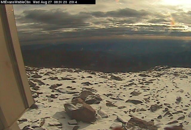
August 27, 2014 – Dawn reveals fresh snow on top of Mount Evans. (DU)
Snow at the Centennial State’s elevations can occur any time of year and last night Mother Nature delivered a white reminder that fall and winter are not far behind.
On Monday, the Colorado Department of Transportation closed the road to the top of Mount Evans due to the potential for snowfall. That potential was realized overnight last night as the observatory webcam this morning showed a couple of inches of snow on the ground.
This morning CDOT’s website reports the road is, “Closed from Summit Lake to top of Mount Evans due to adverse conditions. There is no estimated time of opening.”
The highest paved road in North America, the road to the summit of Mount Evans usually remains open until the first weekend of October when conditions prevent it from being maintained. It doesn’t reopen until the Friday before Memorial Day.
Other areas of the high country saw light doses of snow last night.
At 8:20pm last night the National Weather Service reported that 13,495 foot high Berthoud Pass was reporting 34 degrees. Moderate snow was falling and visibility had been reduced to 1/2 mile.
Snowfall above timberline will be possible tonight with potential accumulations of 1 to 2 inches in some locations.
Stay up to date with the dynamic weather: Be sure to ‘like’ us on Facebook, follow us on Twitter and add us to your Google+ circles.
CDOT crews work to clear an avalanche that has covered US 40 over Berthoud Pass. Click to view a larger image. (CDOT)
With hurricane force winds and heavy snowfall conditions in Colorado’s high country have been treacherous in recent days. The search continues for a snowboarder that disappeared at the height of the storm and an avalanche keeps US 40 over Berthoud Pass closed.
The winter storm that struck yesterday brought with it winds to 99 mph near Loveland Pass and 85 mph near one of the Breckenridge Ski Area mountains. The strong winds coupled with the snow that fell has created dangerous avalanche conditions in the high country.
For all the latest, follow us on Twitter and join us on Facebook
US 40 over Berthoud, US 6 over Loveland Pass and Interstate 70 were all closed at some point over the past 36 hours. I-70 has reopened but US 6 remains closed due to adverse conditions and avalanche control work.
While the skies have cleared over US 40 and Berthoud Pass, the massive avalanche has forced the highway to remain closed. Images released by the Colorado Department of Transportation (CDOT) show the highway completed covered from the slide. No ETA has been provided as to when the pass will open.
Editor’s note – CDOT reports Berthoud Pass opened at 5:40pm. Read on though for for other information.
Search and rescue teams from Grand County were also combing the Berthoud Pass area for a missing snowboarder and his dog although it is unknown if that is in the same location as the avalanche. 26-year-old Jeffrey Miller, his dog and a companion were separated at the height of yesterday’s storm. The severe weather conditions have limited the search for Miller.
The snow from the avalanche has completely covered US 40 over Berthoud Pass. Click the image for a larger version. (CDOT)
An Avalanche Warning is in effect for the Front Range mountain areas as well as the Vail and Summit County Areas. The Colorado Avalanche Information Center warns of high danger levels saying, “Natural and human-triggered slides are likely in avalanche terrain where significant storm and wind-blown snow has accumulated.” Most other areas in Colorado have been given a “considerable” danger rating for avalanches.
Colorado’s weather this winter has been a story of two halves. The eastern half of the state and the Denver area have been warmer and much drier than normal. The western half of Colorado however has had a great deal of snow with some basins reporting more than 130% of normal snowpack.
Image of Interstate 70's new alignment through Glenwood Canyon. Further repairs are needed to restore the highway completely. (CDOT) See a complete series of photos of the slide and repairs in the slideshow below.
Boulders the size of semi-trucks did significant damage to the interstate. A hole on the westbound sound measured 20 feet by 10 feet and one on the eastbound side was 6 feet by 6 feet.
Crews worked in recent days to remove one rock that was 20 feet in diameter and smaller threats on the mountain while others worked to repair the roadway below.
The extensive damage caused to the highway will result in limits on traffic through the affected area for the near future. Only one lane in each direction is open now and the speed limit has been reduced to 40 mph. Trucks over 14 feet wide are not permitted in the area.
CDOT said they would provide more information tomorrow as to how long complete repairs will take. In a statement they said the new restrictions “will remain like this until long-term repairs can be completed in the coming weeks/months.”
Slides in Glenwood Canyon are not entirely unusual due to the rugged terrain and the varying weather conditions experienced in the area. Storms, snow melt and runoff, and even minor seismic activity can set loose the sides of mountains.
The stretch of I-70 through Glenwood Canyon was the final piece of the interstate highway system to be completed in the United States. When it was finished in 1992 the 15-mile stretch was considered a major engineering accomplishment.
Massive boulders lie strewn on Interstate 70 through Colorado's Glenwood Canyon Monday morning. (CDOT)
A rockslide that dropped boulders the size of semi-trucks has forced the Colorado Department of Transportation (CDOT) to close I-70 in both directions. Officials are unable to provide an estimate on when the road will reopen as damage is extensive on both east and west bound sides.
CDOT spokesperson Stacey Stegman said the boulders were big enough to punch holes into the surface of the highway. Some are large enough that moving them as they are may not be an option – they instead will have to be blown apart into smaller pieces.
CDOT reported on Twitter that the boulders ranged in size from 3 to 10 feet with the largest weighing 66 tons. The largest hole on the westbound side of the highway measures 20 feet by 10 feet and the largest on the eastbound side measures 6 feet by 6 feet.
The slide occurred near mile marker 125, west of Hanging Lake Tunnel. Officials said they were lucky the slide occurred at 12:09am when traffic on the highway was at a minimum.
Interstate 70 is closed in both directions between mile markers 116 and 133. CDOT says it could be a couple of days before traffic is able to utilize the route.
The shortest detour around the slide area is not a quick one requiring nearly a 200 mile route. Drivers are being encouraged to use U.S. 40 through Steamboat Springs or U.S. 50 through Montrose and Gunnison.
")
")
 See a complete series of photos of the slide and repairs in the slideshow below.")
")
