With 1.80 inches having fallen in the bucket yesterday afternoon and evening, Thornton saw a big boost in our rainfall totals for July and the entire year.
In fact, the 1.80 inches from that one storm was more precipitation than we had seen in any single month yet this year.
It did push the month’s rainfall total to above the 11 year average for July however, for 2018 we are still lagging almost 2 inches below what we would normally see by the end of July.
There are still seven days left in the month and monsoonal flow does look to be present in the coming days so we certainly could see things improve further.
A fast-moving wildfire burning near Fort McMurray, Alberta has prompted the evacuation of all 88,000 residents of the city. Since the fire started Sunday, at least 1,600 structures have been destroyed.
On May 4, 2016, the the Enhanced Thematic Mapper Plus (ETM+) on the Landsat 7 satellite acquired this false-color image of the wildfire that burned through Fort McMurray in Alberta, Canada. The image combines shortwave infrared, near infrared, and green light (bands 5-4-2). Near- and short-wave infrared help penetrate clouds and smoke to reveal the hot spots associated with active fires, which appear red. Smoke appears white and burned areas appear brown.
We may not have received any real snow the last two days but it is hard to complain when you consider just how much we have received this season.
Thus far Thornton has recorded 76.0 inches snowfall, the second highest seasonal total since we came online 10 years ago. Those numbers are likely to get higher as snow in April is almost certain and snow in May would not be unusual.
Out at DIA where Denver’s official totals are kept, 57.2 inches has been received. The Mile High City’s long term average (1882-2015) is 57.1 inches.
It was sure slow coming with most of the day featuring a light rain / snow mix. At about 4:00pm the snow finally began in earnest. The video below was taken from the ThorntonWeather.com backyard.
Satellite imagery provides bird’s eye view of Earth at the change of seasons.
Pretty neat imagery and explanation from NASA:
Enjoy the Equinox!
Every year, there are two equinoxes. One is in March; the other is in September. In 2014, the March equinox falls on March 20, 2014. On the equinoxes, the sun shines directly on the equator and the length of day and night is nearly equal. Seasons are opposite on either side of the equator, so the March equinox is called the spring (or vernal) equinox in the northern hemisphere. But in the southern hemisphere, it’s known as the fall (autumnal) equinox. What do equinoxes look like from space? The Spinning Enhanced Visible and Infrared Imager (SEVIRI) on EUMETSAT’s Meteosat-9 captured these four views of Earth from geosynchronous orbit. The images show how sunlight fell on the Earth on December 21, 2010 (upper left), and March 20 (upper right), June 21 (lower left), and September 20, 2011 (lower right). Each image was taken at 6:12 a.m. local time. Notice how on March 20 and September 20, the terminator — the divide between day and night — is a straight north-south line, and the Sun is said to sit directly above the equator. Equinox means “equal night” in Latin, capturing the idea that daytime and nighttime are equal lengths everywhere on the planet.
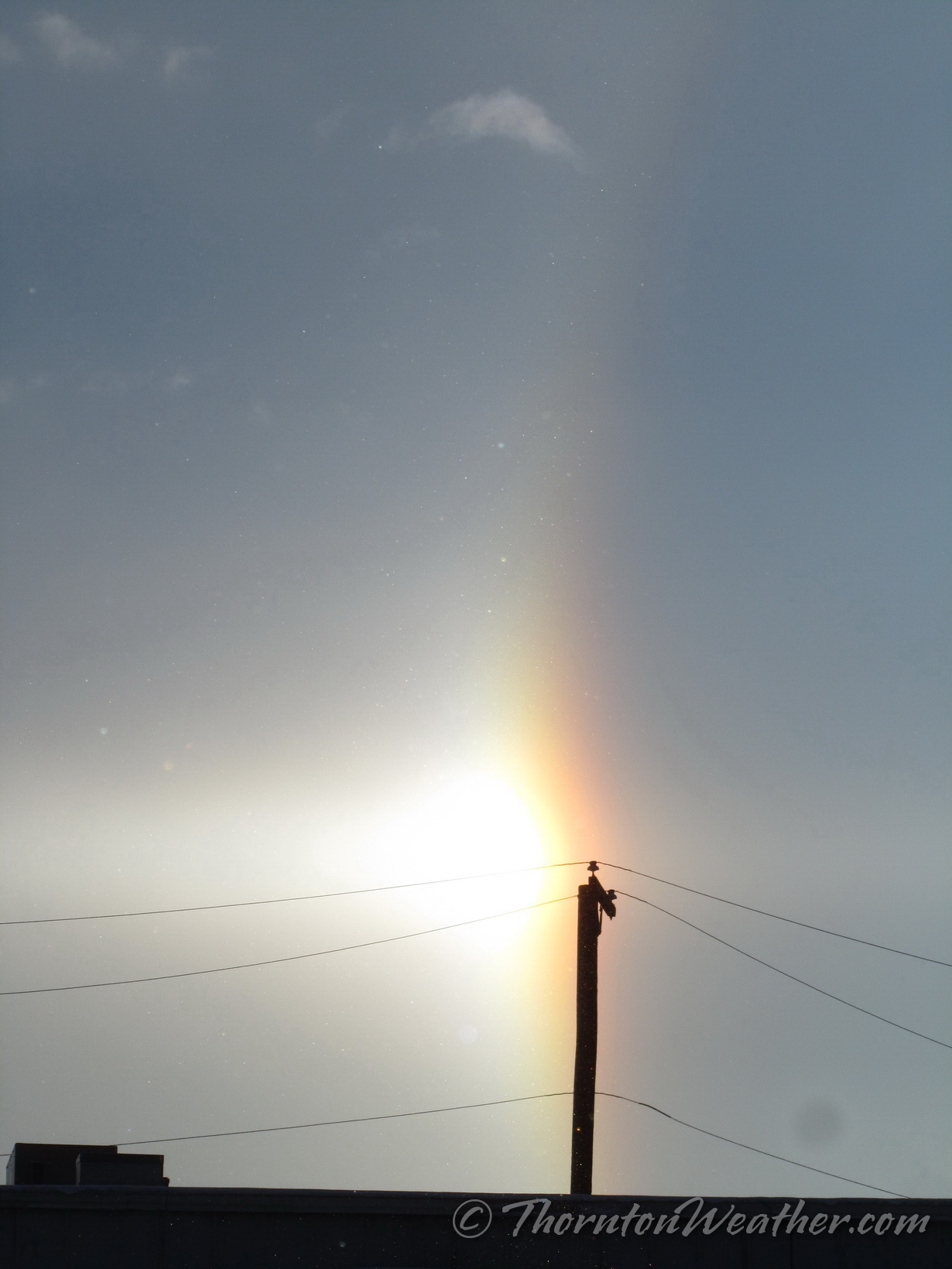
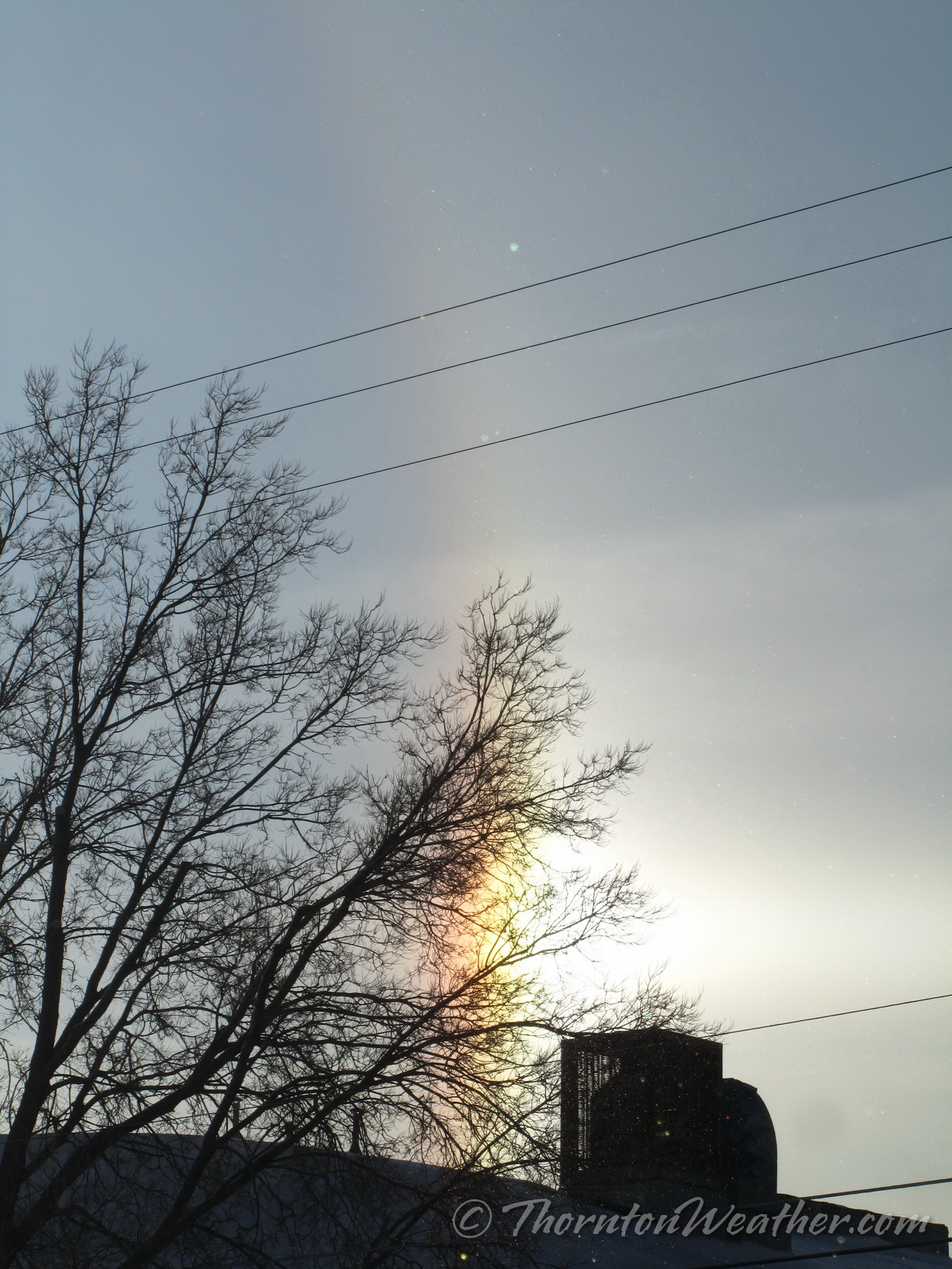
If you happened to look to the east at about 7:45 a.m. this morning you were treated to something pretty cool – a sun dog.
A sun dog is also called a ‘mock sun’, ‘phantom sun’ or ‘parhelia.’ These appear as bright spots to either side of the sun at the same distance above the horizon. They are caused by sunlight refracting through hexagonal ice crystals, usually in cirrus clouds. As the light hits the crystals, it is bent 22 degrees before reaching your eyes, thus creating the phenomena.
We took these images in north Denver.
February 5, 2014 – The full, bright sun dog. (ThorntonWeather.com)February 5, 2014 – The north ‘mock sun.’ (ThorntonWeather.com)February 5, 2014 – The south ‘mock sun.’ (ThorntonWeather.com)
Sunday morning the virtually full moon brightened the landscape. Captured just before dawn, the image below is technically two days late to be one of the truly full Hunter’s moon but it still appears fully lit.
The Hunter’s Moon is the traditional term for the second full moon of autumn, following the Harvest Moon, the first of the season. Typically this makes it the full moon we see in October but it can sometimes fall in November.
The name is popularly attributed to Native Americans and said to be named such because it meant it was time to go hunting and prepare for the arrival of winter.
More than folklore, there is something unique about the Hunter’s Moon. See below the image for more details.
A very bright moon lights up the landscape two days after the full Hunter’s Moon. Click the image for a larger view. (ThorntonWeather.com)
But the Hunter’s Moon is also more than just a name. Nature is particularly cooperative around the time of the autumn equinox to make the full moonrises unique around this time.
Here’s what happens. On average, the moon rises about 50 minutes later each day. But when a full moon happens close to the autumnal equinox – either a Harvest or a Hunter’s Moon – the moon (at mid-temperate latitudes) rises only about 30 to 35 minutes later daily for several days before and after the full moon.
Why? The reason is that the ecliptic – or the moon’s orbital path – makes a narrow angle with the evening horizon around the time of the autumn equinox. The narrow angle of the ecliptic results in a shorter-than-usual rising time between successive moonrises around the full Hunter’s Moon.
These early evening moonrises are what make every Hunter’s Moon special. Every full moon rises around sunset. After the full Hunter’s Moon, you’ll see the moon ascending in the east relatively soon after sunset for a few days in a row at northerly latitudes.
This morning’s satellite imagery runs are showing some interesting white cover on Colorado’s landscape and it isn’t clouds. In fact, we see virtually entirely cloudless skies across the state.
That white stuff is in fact snow, the first covering of the season at higher elevations. Some locations Sunday night / Monday morning received up to six inches of the white stuff.
Satellite imagery clearly shows the snow in parts of the San Juan Mountains to the southwest as well as the Elk and Sawatch ranges, the Flat Tops and even the western parts of the Front Range mountain areas.
It likely won’t be long before the Front Range sees its own snowfall. Denver’s first freeze on average occurs on October 7th. Its first snowfall on October 19th.
This year on September 3 Denver reached an official high temperature of 94 degrees. Here in Thornton we topped out at 95 degrees.
Providing a stark contrast is a look back at this date 52 years ago.
On September 3, 1961 a winter-like system delivered 4.2 inches of snow to the Mile High City with the foothills receiving a foot of the white stuff. This is the earliest date for a seasonal snowfall on record. Temperatures that day dropped to 33 degrees, the earliest in the season it has ever been that cold.
The comparison highlights the extremes that Colorado can experience in September (much like most other months). Which would you prefer? Heat or snow?
Many folks noticed the lack of new stories post last week other than a photo or two on our Facebook page. We took the week off for some much needed R & R and were able to enjoy one of our favorite parts of the state.
The image below was taken in Gunnison National Forest a little ways north of Taylor Reservoir. In the foreground is Lilly Pond, in the background the Collegiate Peaks.
The stunning greens and blues truly were as bright as the image shows. While rain was far too prevalent for our liking during our time in the area, the scenery was amazing.
Lilly Pond and the Collegiate Peaks in Gunnison National Forest (ThorntonWeather.com). Click for a larger view.
Weather, natural disasters & climate news and information.


")
.")