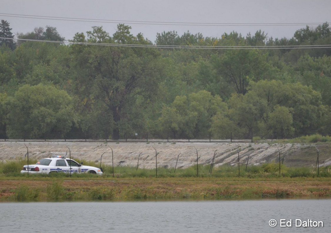
Water flows over the banks of the South Platte River into Sprat-Platte Lake near Thornton on the afternoon of September 12, 2013. Click for a larger view. (Ed Dalton)
What has been called a 100-year storm and even referred to as being of ‘biblical’ proportions is very slowly coming to an end. The worst of the rain fell on Thursday, September 12 with locations in Colorado’s foothills reporting in excess of 8 inches of rainfall.
Among the hardest hit areas were the college town of Boulder and picturesque Estes Park. Both cities have seen extensive flooding and damage totals across the state will be well into the tens, if not hundreds, of millions of dollars.
The two videos below capture the raging waters as they pummeled the communities.
The first video shows Boulder as well as some commentary by Gov. John Hickenlooper. The second is of downtown Estes Park.
Don’t miss a thing when it comes to our ever-changing weather! Be sure to ‘like’ us on Facebook, follow us on Twitter and add us to your Google+ circles.
Many folks noticed the lack of new stories post last week other than a photo or two on our Facebook page. We took the week off for some much needed R & R and were able to enjoy one of our favorite parts of the state.
The image below was taken in Gunnison National Forest a little ways north of Taylor Reservoir. In the foreground is Lilly Pond, in the background the Collegiate Peaks.
The stunning greens and blues truly were as bright as the image shows. While rain was far too prevalent for our liking during our time in the area, the scenery was amazing.
Lilly Pond and the Collegiate Peaks in Gunnison National Forest (ThorntonWeather.com). Click for a larger view.
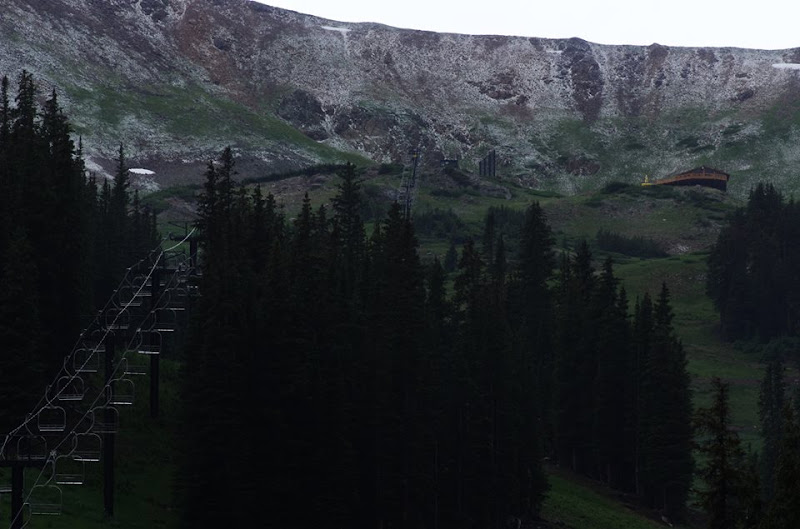
July 18, 2013 – Loveland Ski Area received a dusting of snow. While a bit unusual in mid-summer, certainly not unheard of given an altitude at the base of 10,800 feet. (Loveland Ski Area)
At an altitude of 10,800 feet, Loveland Ski Area is certainly in some rarified air. Yesterday the resort saw a dusting of snow while Colorado residents below in the Mile High City simmered in 90+ degree temperatures.
Snowfall can occur in Colorado’s high country any time of year, even in mid-summer, and yesterday’s event was not particularly unusual.
Here in Denver however there has never officially been snow in July. The key word though is ‘officially.’
Unofficially there has been snow in the Mile High City in July – almost exactly one year ago today in fact.
Check out this tidbit from the National Weather Service archives:
“On July 17, 1872…the U.S. Army Signal Service weather observer recorded snowfall during the early morning hours in the hand written daily weather journal: “rain commenced at 1:30 a.m. changing about 3 a.m. to snow & in about half an hour to rain again; it continued until 6 a.m.” This is the only recorded occurrence of snowfall in Denver in July…but this report is not included in the “official” station snowfall records…which did not begin in Denver until January 1…1882. The low temperature on this morning was 45 degrees…which is sufficiently cold for the occurrence of light stratiform snowfall.”
Satellites provide an amazing eye in the sky for monitoring the weather and climate. Their usefulness today was once again proven as they captures wildfires exploding in Colorado’s southwest and thunderstorms to the northeast.
The satellite imagery animation comes from the NOAA GOES East satellite and was assembled by Colorado State University RAMSDIS. It covers the period from 1:55pm to 4:40pm on Friday, June 21, 2013.
The tandem West Form Fire and Papoose Fire in southwestern Colorado are seen sending massive smoke plumes into the sky. Afternoon thunderstorms are exploding in the northeastern corner of the state.
Wildfires are a very real danger here in Colorado.
As wildfires burn across much on the western United States late this summer, the Internet can be a wealth of information for residents that are affected by these blazes or for anyone else. Resources are available for everything from the latest news updates, finding out where the fires are right down to the street level, to safety and education.
This list is by no means all inclusive – if you have a wildfire related link we are missing, please post a comment and let us know and we will update our list!
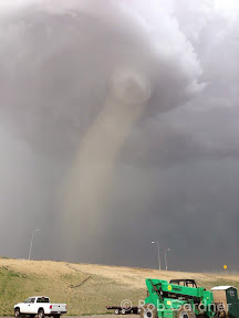
The tornado near DIA sent workers working on the terminal renovations scrambling. (Rob Gardner)
The tornado that struck on the grounds of Denver International Airport (DIA) on Tuesday, June 18, 2013 has been rated an EF1 with winds up to 109 mph. The twister came within a half mile of Concourses A and B and sent workers and travelers scrambling to tornado shelters.
Scroll down to see more photos of the tornado.
From the National Weather Service:
A tornado developed on Denver International Airport (DIA) grounds on the afternoon of June 18, 2013. The tornado formed around 2:19 PM just north of 70th Avenue. The tornado then moved slowly northwest between Runway 35R and 35L, and moved to within a half mile of Concourses A and B before dissipating at 2:36 PM. The tornado moved extremely close if not over the ASOS (Automated Surface Observation System) and another low level wind shear sensor at DIA. The ASOS weather observing system reported a 97 mph wind gust at 2:27 PM, while the wind shear sensor reported a wind gust to 109 mph at the same time – indicative of an EF1 tornado. There was only minor damage noted to this equipment. The storm responsible for this tornado first developed just south of the airport, and then drift slowly northward across the eastern side of DIA. At 2:05 PM, there was weak rotation beginning to develop underneath this storm as noted by the velocity data below. This rotation then strengthened quickly between 2:10 and 2:22 PM.
One of our favorite pastimes is simply watching the clouds. Colorado’s widely varying weather provides a stunning variety in almost every season. One photographer captured an amazing time lapse video of what he called “Bubbly Rocky Mountain Clouds.”
Colorado’s weather can be challenging to predict with all four seasons being seen in a single day across the state.
Weather forecasters have come under fire in recent weeks due to over or underestimating the amount of snowfall from our winter-like weather. Colorado presents very unique challenges, particularly with snow estimates, and 9News tried last night to address some of those.
In conversations with the station’s meteorologists Kathy Sabine and Marty Coniglio, reporter Chris Vanderveen tries to explain the hit or miss forecasts.
“It’s now not good enough to say ‘it’s going to snow.’ It’s not enough to say ‘it’s going to snow from this time on this date to this time on this day.’ Now, it’s the exact amount of snow in the exact location.”
It’s that expectation that doesn’t mix well in particular with forecasting snow accumulation. Coniglio says it’s realistic to give a range, but Colorado’s varying terrain and unpredictable winds make it virtually impossible to guarantee a particular accumulation in a given area.
It is certainly an interesting topic and one which many Coloradoans upset about snowfall estimates being inaccurate should watch. The story does fall short with only being 3 minutes long and failing to adequately explain the challenges with the weather in Colorado.
NASA satellite imagery shows the Colorado Front Range covered in snow following a snowstorm on Sunday, February 24, 2012.
Up until the past week satellite imagery of northeastern Colorado was relatively boring – and very brown. In the wake of two storms, one of which was relatively significant, the image from the eyes in the sky changed considerably.
Sunday’s storm brought much-needed precipitation to the drought-stricken area. Snowfall totals ranged from a high of nearly 27” near Pinecliffe west of Denver to 9.1” in the Mile High City and 6.9 inches in Thornton.
As the storm continued east on Monday it caused havoc on parts of Texas and Oklahoma where blizzard conditions brought that region to a standstill.
NASA’s Terra satellite flew over the Centennial State yesterday after skies had cleared and took pictures from 22,000 miles above. The imagery clearly shows the snowy landscape of Colorado as well as parts of Utah, New Mexico, Kansas, Oklahoma, Nebraska and Wyoming.
NASA satellite imagery shows parts of nine states covered in snow following a snowstorm on Sunday, February 24, 2012.
From NASA:
Following on the heels of another storm, heavy snow fell on Colorado and neighboring states on February 24, 2013. On February 25, the Denver/Boulder Forecast Office of the National Weather Service reported preliminary snow totals from the area, including 27.2 inches (69.1 centimeters) west of Denver, and blizzard conditions east of the city. Like the previous storm, this one continued moving eastward.
The Moderate Resolution Imaging Spectroradiometer (MODIS) on NASA’s Terra satellite acquired this image on February 25, 2013. In the wake of the storms, snow extended across Colorado and Wyoming, and covered parts of Utah, New Mexico, and Nebraska. Although clouds had cleared in the west, cloud cover lingered in southeastern Colorado, western Kansas, and the Oklahoma Panhandle. The day after MODIS acquired this image, a new round of snow moved into the region.
References
National Weather Service, Denver/Boulder, Colorado. (2013, February 25) Local storm report. National Oceanic and Atmospheric Administration. February 26, 2013.
The Visible Infrared Imaging Radiometer Suite (VIIRS) on the Suomi NPP satellite captured this nighttime view at 1:55 a.m. Central Standard Time on February 23. (NASA)
From NASA:
In late February 2013, a major snowstorm made its way across the continental United States, dropping snow from Colorado to the Great Lakes region. The National Weather Service reported snow totals of 5 to 8 inches (13 to 20 centimeters) in many parts of the Central Plains and Upper Mississippi River Valley. Some parts of the Central Plains experienced snowfall rates as high as 4 inches (10 centimeters) per hour, along with thundersnow.
The Visible Infrared Imaging Radiometer Suite (VIIRS) on the Suomi NPP satellite captured this nighttime view at 1:55 a.m. Central Standard Time on February 23. This imagery is from the VIIRS “day-night band,” which detects light in a range of wavelengths from green to near-infrared. The day-night band takes advantage of moonlight, airglow, and starlight to brighten the landscape and uses filtering techniques to observe signals such as city lights and snow cover. On the night of this image, the Moon was nearly full.
City lights glow like clusters of stars against a backdrop of grey and black in this image. The snow appears medium gray, and stretches from northern Texas to the Dakotas,and from the Rocky Mountain states eastward past Chicago. When VIIRS acquired this image, snow cover across multiple states had persisted since theprevious night.
References
National Weather Service, La Crosse, Wisconsin. (2013, February 23) Winter Storm February 21–22, 2013. National Oceanic and Atmospheric Administration. February 25, 2013.
NASA Earth Observatory image by Jesse Allen and Robert Simmon, using VIIRS day-night band data from theSuomi National Polar-orbiting Partnership. Suomi NPP is the result of a partnership between NASA, the National Oceanic and Atmospheric Administration, and the Department of Defense. Caption by Michon Scott.
The recent snowstorm didn’t bring all that much snow to Thornton, 6.9 inches, but it was our biggest snowfall in over a year and delivers some much needed precipitation. The light, fluffy snow was easily blown around by winds gusting in excess of 32 mph which limited visibility and made conditions outside harsh.
The video below captures the event from our east facing camera beginning at 6:00pm on Saturday, February 23, 2013 and continuing through 6:00am on Monday, February 25, 2013. Light snow is seen falling soon after 10:00pm on Saturday night and following a lull, really picks up by mid-morning Sunday.
Weather, natural disasters & climate news and information.
.")


 on the Suomi NPP satellite captured this nighttime view at 1:55 a.m. Central Standard Time on February 23. (NASA)")