The recent snowstorm didn’t bring all that much snow to Thornton, 6.9 inches, but it was our biggest snowfall in over a year and delivers some much needed precipitation. The light, fluffy snow was easily blown around by winds gusting in excess of 32 mph which limited visibility and made conditions outside harsh.
The video below captures the event from our east facing camera beginning at 6:00pm on Saturday, February 23, 2013 and continuing through 6:00am on Monday, February 25, 2013. Light snow is seen falling soon after 10:00pm on Saturday night and following a lull, really picks up by mid-morning Sunday.
Northeastern Colorado received a much needed wallop of snow and the accompanying precipitation.
The heaviest snowfall was in the southern and western suburbs and foothills. In Thornton the storm was less generous but nevertheless welcome.
Pinecliffe west of Golden was the prize winner with nearly 22 inches of snow. Further to the south Conifer received 15 inches. In the metro area most snowfall totals were in the 6 to 10 inch range with the higher amounts to the south.
The interactive map below shows snowfall reports from National Weather Service storm spotters. You can double-click to zoom in or use the + / – buttons. Click and hold and then drag to pan the map around. Click on any ‘dot’ to see the report for that location.
Today, February 5th, we celebrate one of our nation’s most important holidays – National Weatherperson’s Day. In what is truly a very revered occasion, we take time out to honor those men and women who bring joy to schoolchildren when they announce a snow day, are the bearers of bad news when severe weather is about to strike and are prognosticators second only to Jimmy the Greek in their ability to read a crystal ball. Read more about this auspicious occasion on Examiner.com.
The 2012 / 2013 snow season has been dismal and while December brought some hope for recovery, recent weeks have seen snowpack decline once again. For the drought and fire weary state of Colorado the data does not bode well.
For the north-central Colorado mountains, the January 22 snowpack is at its second lowest level to date since 1979. Only 1981 saw worse results this far into the season.
According to the latest Colorado SNOTEL reports, the South Platte, North Platte and Upper Colorado River basins are at 57%, 65% and 60% of normal respectively. Statewide Colorado snowpack is a dismal 62% of average.
Is there hope? Mother Nature certainly works on her own schedule so it is possible we could see a recovery. However the latest 3-month outlook from the Climate Prediction Center forecasts warmer and drier than normal temperatures.
North-central Colorado snowpack through January 22. Click the image for a larger view. (NRCS)
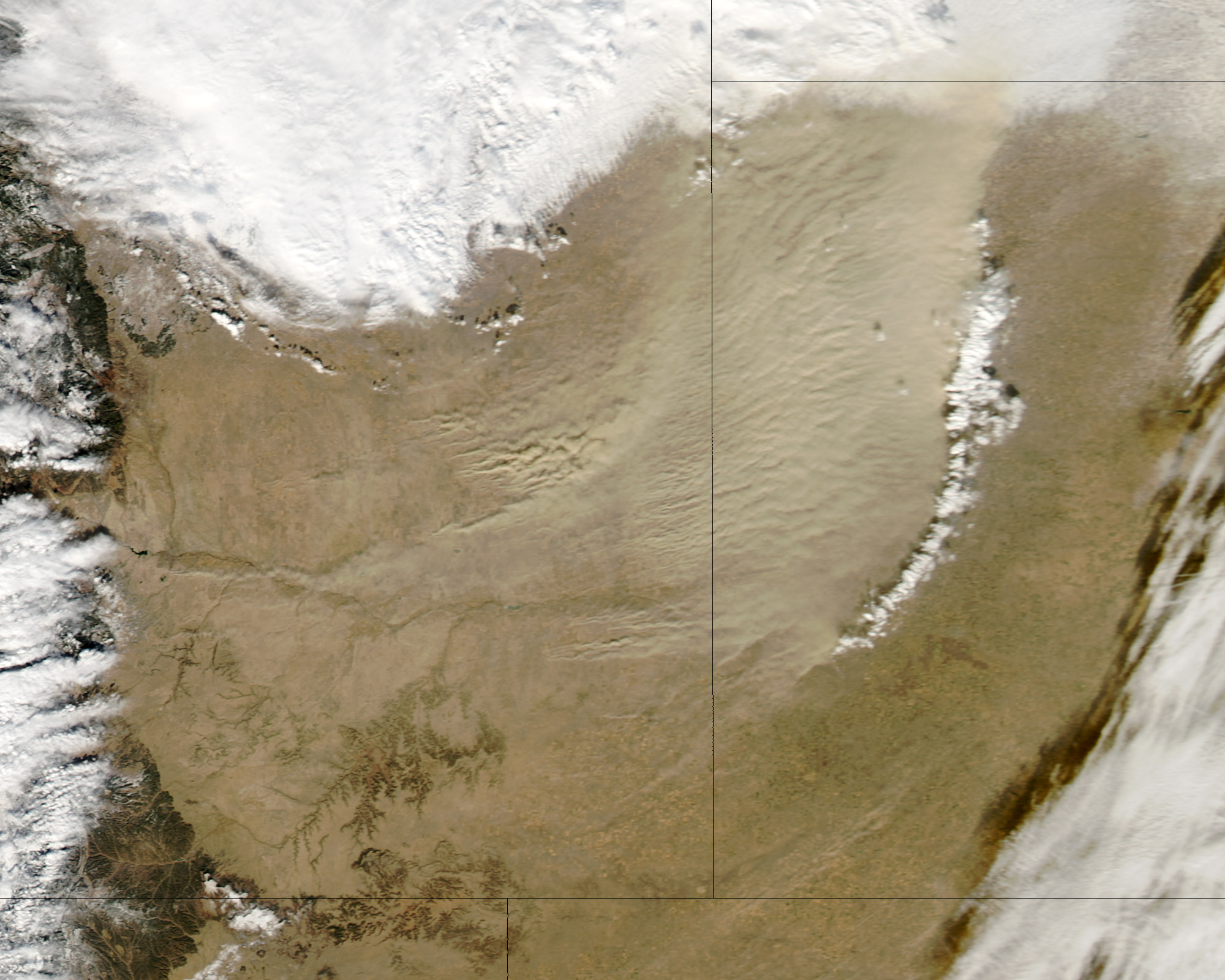
When a cold front pushed through Colorado late last week not only did it bring bitter cold temperatures, it also brought a great deal of wind to the state’s southeastern plains. NASA’s Aqua satellite was able to capture images of the ensuing dust storm as the cold front pushed through.
As wind speeds increased dust was thrown aloft in southeastern Colorado on Friday, January 11. The intensity of the dust storm was undoubtedly aided by the dry landscape in what is the most parched part of the state.
Satellite imagery captured the dust storm as it moved into Kansas.
NASA writes:
Although the dust was thickest in western Kansas, many of the source points for the storm were in Colorado. One dust plume arose roughly 70 kilometers (40 miles) south of Colorado Springs. In Kansas, the eastern edge of the dust storm spanned 240 kilometers (150 miles) and the dust was thick enough to completely hide the land surface below, especially east of Goodland. Salina.com reported that the blowing dust reduced visibility to a quarter of a mile (0.4 kilometers).
The Moderate Resolution Imaging Spectroradiometer (MODIS) on NASA’s Aqua satellite captured this image of a dust storm in southeastern Colorado and western Kansas on January 11, 2013. (NASA)
The wintry weather that moved through Colorado over the past 48 hours provided some relief to the drought-stricken state. NASA satellites captured the snowy landscape of the Centennial State as the storm moved off toward the Midwest.
The system covered much of the higher elevations of the Rocky Mountain region in snowfall. For Colorado this brought snow to the high country much to the delight of ski resorts and skiers.
In Denver the storm brought very cold temperatures but not as much snow as was hoped. Officially the Mile High City recorded 1.7 inches bringing the seasonal total to 9.8 inches, well below normal.
The image from NASA’s Aqua satellite was taken on Wednesday, December 19 as the storm began to move out onto the plains. The snow covered mountains west of Denver are clearly seen while cloud covers the lower elevations.
Satellite imagery shows the pre-Christmas snowstorm that blanketed Colorado. Click the image for a larger view. (NASA)
Severe weather more typical of June than late September hit Colorado yesterday.
September weather in Colorado is typically tranquil and one of the more pleasant months in the state. This week however that wasn’t the case, especially yesterday when severe thunderstorms rumbled across the parts of the state.
Tuesday and Wednesday brought heavy rains to parts of the northern Front Range. The precipitation was welcomed as it provided much-needed relief from the recently dry conditions.
Yesterday in Colorado Springs and La Junta thunderstorms brought hail that accumulated up to 6 inches deep. Mother Nature however held more surprises as she brought tornadoes to other parts of the state.
Three tornadoes were reported in northeastern Colorado – one each in Adams, Douglas, and Weld counties. None of the three caused any damage.
A fourth twister however occurred in southern Colorado near Del Norte in Rio Grande County northwest of Alamosa. Local resident Julie Sauvigne captured amazing video of the tornado as it ripped through her property causing EF0 level damage to her home.
Watch the video below. Notice how the visible funnel is almost directly above Sauvigne while the circulation on the ground was occurring in a field nearly a mile away!
In an effort to keep up with new technology and improve warnings to residents, the city of Denver began a much-needed upgrade of its outdoor warning sirens yesterday. The system will feature improved reliability and the ability to target warnings. Read about Denver’s new system on Examiner.com.
With an unusually warm summer and very dry conditions Mother Nature has moved up the timetable to view Colorado’s natural autumn gold. This weekend will be the prime time to take a drive to view the changing foliage in the high country. Find out some of the best places in the mountains to view the changing leaves.
Snow covers Colorado's Pikes Peak on the morning of Thursday, September 13, 2012 following a storm system. (City of Colorado Springs) Click the image to view a slideshow of the recent snow.
Weather, natural disasters & climate news and information.

 Northeastern Colorado received a much needed wallop of snow and the accompanying precipitation.