All posts by Examiner.com

110 years ago: Looking back at the Great Colorado Snowstorm of 1913

A man on skis navigates the monstrous December 1913 snowstorm in Denver. (Denver Public Library Special Collections)

Significant snow events in Colorado are not unusual however some are nothing short of epic. Such was the case with the Great Colorado Snowstorm of 1913, a storm that occurred 110 years ago today and still stands as the largest snow event in Denver history.

It was a classic setup. Low pressure to Colorado’s southwest slowly moved to the northeast drawing in moist air – and dropping snow along the Front Range.

The first three days of the storm were relatively calm with Denver only seeing 8 inches. On the 4th and 5th however Mother Nature let loose with 37.4 inches of snow.
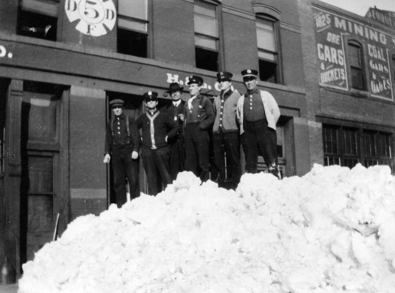
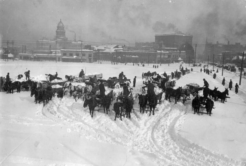
The total for the event, 45.7 inches, was and still is the heaviest single snowfall event in Denver history. To the west, Georgetown recorded an even more amazing 86 inches, 63 of which fell on the 4th of the month alone.

The Denver Post headline on December 5, 1913 read, “Denver in Mantle of Shimmering White, Stops Activity and Everybody Jollifies.”

A subheading said, “All Denver is Waking Amid Ghostly Silence of Streets That Are Buried – Whole State Fells Storm of Varying Intensity.”

The Post’s now defunct competitor, the Rocky Mountain News, saw a silver lining. Its headline read, “Colorado Gripped by Worst Snowstorm Recorded in 28 Years; Denver is Hit Hard, but Blizzard Means Millions in Crops.”

Indeed, in a day long before four wheel drive existed and when horse and carriage were as common as cars, the storm had a tremendous impact.

Travel was brought to a complete halt in the area as snow drifts blocked all roads. Trolleys were unable to run downtown and railroads in and out of the city were stopped. It would be a week before streetcar service was returned to normal.

Stranded workers were housed at the city auditorium, jail and movie theatres. Telegraph, telephone and electrical service were interrupted as the snow downed lines across the area. Schools were closed at the height of the storm and some remained shuttered for days.

Any open space in the city became a snow dumping ground as the city dug out. The Rocky Mountain News reported that anyone needing work could help the Tramway company with snow removal. Pay was $3.50 per day.

Despite the ferocity of the storm, accounts of the day indicate only a few fatalities. Dozens of buildings did collapse under the sheer weight of the snow.

The Great Colorado Snowstorm coupled with smaller events over the rest of the month yielded a snowfall total for December 1913 of 57.4 inches, the snowiest month ever recorded in Denver. Additionally, 5.21 inches of precipitation was recorded making the month the wettest December on record.

Tornado outbreak hits seven states, kills at least 18 in the South

A screen capture from video shot by a civilian drone shows the devastation caused by a tornado in Mayflower, Arkansas. (YouTube / briandjin2)

Tornado activity in the United States had been at record low levels before this weekend. Mother Nature came roaring back to life Sunday however spawning a deadly outbreak of twisters with more expected Monday.

The National Weather Service’s Storm Prediction Center accumulated reports of 31 tornadoes Sunday although the actual number will likely be less once analyzed. Seven states including Nebraska, Iowa, Kansas, Arkansas, Oklahoma, Louisiana, and Mississippi reported twisters.

Hardest hit were the towns of Mayflower and Vilonia near Little Rock, Arkansas. Entire sections of the towns were reduced to their base building materials as the twisters struck late in the day Sunday.

Read the rest of this story on Examiner.com

Video: Dust devil strikes during controlled burn at Rocky Mountain Arsenal

A prescribed burn at the Rocky Mountain Arsenal quickly got out of control when swirling winds struck.Performing prescribed burns is an important way to clear brush and renew wildland and are often done without any excitement. Mother Nature had other plans last week however as whirling winds propelled a fire beyond its containment lines at the Rocky Mountain Arsenal National Wildlife Refuge.

The amazing video of the event on March 14 was taken by a firefighter from South Metro Fire and showcases how quickly weather conditions can change and how even when well-planned, fires can quickly get out of control.

The fire is seen burning through the grasslands of the refuge when swirling wind develops – a common phenomenon caused by the heat quickly rising from the fire. Soon the fire begins to rage and tumbleweeds and burning debris are sent flying in a circular path.

Thomas Rogers, the man behind the camera, said on YouTube the fire burned an additional acre as crews backed off to gain the upper hand.

Refuge Manager David Lucas said on Facebook, “What we saw and how we reacted is exactly what we want out of our fire crews — well planned with plenty of on-site resources to manage contingencies, safety first, and well trained folks who got after it quickly.”

Video: Los Angeles news anchors scramble under desk during earthquake

Location map of the epicenter of the magnitude 4.4 St. Patrick's Day earthquake in Los Angeles.A magnitude 4.4 earthquake struck the Los Angeles area Monday morning in the pre-dawn hours. While a relatively minor quake, it was strong enough to rattling residents and send morning TV news anchors under their desks.

According to the US Geological Survey (USGS) the quake was centered 6 miles west of Beverly Hills and at a depth of 5.3 miles. Occurring at 6:25 a.m. local time, a light aftershock of magnitude 2.7 was recorded at 7:23 a.m.

Residents stretching from Mission Viejo to the south and Oxnard to the north reported feeling the initial temblor. Beyond waking residents that were still sleeping and grabbing the attention of those already awake, initial reports indicate no significant damage.

Television stations were in the middle of their morning broadcasts when the quake hit.

KTLA news anchors Chris Schauble and Megan Henderson reacted quickly announcing that they were feeling the quake. The two acted appropriately and dived under their anchor desks for the short duration of the quake.

Video from the station shows the overhead lights shaking and Henderson noting that dust or ceiling material was falling down.

Massive 104 car pileup on icy roads in Denver kills one, injures dozens

An accident on icy roads south of Colorado Springs resulted in a vehicle rollover and was one of three significant multi-vehicle accidents on I-25.Icy roads Saturday morning led to a massive 104 car pileup on Interstate 25 through central Denver killing one person and injuring 30.

The chain reaction accident began just before 11:00 a.m. near University and Downing on the northbound side of the interstate. Cars, unable to stop on the ice and snow covered highway, began piling up.

One woman was killed in the accident. Her name is currently being withheld. The woman’s vehicle struck the back of a semitrailer, peeling the roof back as it lodged under the trailer.

Thirty people were injured and transported to area hospitals including Denver Health, St. Anthony’s and Swedish Medical Center. Among the injured were adults and children.

Read more about his incredible accident and check out the photos and video on Examiner.com

Arctic chill breaks cold temperature record in Denver

Denver set a record cold maximum temperature for February 5.With a large, cold air mass settled in across much of the nation’s midsection, weather records are bound to fall. In the Mile High City the record for coldest high temperature for the date was not just broken but smashed.

The so-called high temperature for the day was 1 degree below zero in Denver. This shattered the previous coldest high temperature for February 5 of 5 degrees set in 1989 and years prior.

Overnight temperatures Tuesday night into Wednesday morning dropped to a bone-chilling 19 degrees below zero as measured at Denver’s official weather station at Denver International Airport. Daytime provided little relief as the mercury remained stubbornly below zero.

Here in Thornton we fared slightly better with a daytime high temperature of 2 degrees above zero.  Our low temperature this morning was a nasty cold 12.6 degrees below.

With temperatures Wednesday night expected to plunge to 10 below or lower, a Wind Chill Advisory has been issued for much of northeastern Colorado including Denver. Wind chill temperatures of 25 below will be possible.

This type of cold comes with it the very real danger of hypothermia and frostbite. Area residents need to exercise extreme caution and avoid prolonged exposure. Pets as well need to be remembered and their time outside should be limited.

Weather may be the ultimate wildcard in deciding outcome of Super Bowl XLVIII

A crew member works to remove snow from MetLife Stadium, which will host Superbowl XLVIII next month, on January 22, 2014 in East Rutherford, New Jersey.
A crew member works to remove snow from MetLife Stadium, which will host Superbowl XLVIII next month, on January 22, 2014 in East Rutherford, New Jersey. (Getty Images)

Mother Nature and the potential she has to impact Super Bowl XLVIII is a hot topic as the game draws nearer. No matter what happens in the contest between the Denver Broncos and Seattle Seahawks, it is almost certain the game will be the coldest NFL championship ever played and possibly the snowiest.

With the game still more than eight days away, weather forecasts are less than certain about what conditions will be on game day. However a look at historical statistics from the National Weather Service for the New Jersey / New York area provide some clues.

Using 1981 to 2010 climate averages, the normal high temperature for February 2 as measured at Newark is 40 degrees. The average low is a chilly 25 degrees.

The coldest kickoff temperature in Super Bowl history occurred on January 16, 1972. Played at Tulane Stadium in New Orleans, the temperatures at the start of that game was a chilly 39 degrees on the field.

Given that, it is pretty certain this will be the coldest Super Bowl in history.  It could also be the first to have snow fall on the field and freezing rain and wind are other hazards the teams may have to contend with.

Read more about the potential for weather to impact the game on Examiner.com