Tag Archives: September Weather

September 13 to September 19: This week in Denver weather history

This Week In Denver Weather History
September 13 to September 19: This week in Denver weather history

Weather conditions in Colorado can of course vary greatly and we always see that in our weekly look back in the history books.  For this week, we see a dizzying array of weather events from record setting temperatures in the 90’s and summer-like thunderstorms with tornadoes to an early arrival of winter that brought a foot of snow!

5-13

In 2010…the Fourmile Canyon wildfire…northwest of Boulder… Broke out on the morning of the 5th. It originated from an unattended fire pit at a local residence. The wildfire quickly consumed 5 1/2 square miles or 3500 acres the first day…and forced the evacuation of over three thousand residents. Erratic 45-mph gusts sent the fire in two directions at times. Very dry weather conditions preceded the fire. The combination of strong winds…low relative humidities and dry fuels allowed the wildfire spread rapidly through the steep…heavily forested terrain. The flames were reportedly 20 to 50 feet in length. Towns within the burn area included Salina…Wallstreet and Gold Hill. The dry conditions coupled with gusty winds ranging from 45 to 64 mph persisted for several more days. Fire managers used as many as 700 firefighters and support personnel from 35 agencies and seven air tankers to battle the wildfire. A total of 6181 square acres or approximately 10 square miles were burned. The Fourmile Canyon wildfire was the most destructive fire in Colorado history in terms of the damage to personal property. It destroyed 171 homes with an estimated cost of 217 million dollars.

11-16 in 2013…a deep southerly flow over Colorado… Ahead of a nearly stationary low pressure system over the great basin… Pumped copious amounts of monsoonal moisture into the area. In addition…a weak stationary front stretched along the Front Range foothills and Palmer Divide.  This resulted in a prolonged period of moderate to heavy rain across the Front Range foothills…Palmer Divide…urban corridor. By the 14th…storm totals ranged from 6 to 18 inches… Highest in the foothills of Boulder County. The headwaters then moved down the South Platte River and caused widespread flooding with record flood stages at several locations as it made its way downstream.  The record high flood stages resulted in widespread flooding along the South Platte River basin. The flood damage encompassed 4500 square miles of the Front Range…left 7 dead… Forced thousands to evacuate…and destroyed thousands of homes and farms. Record amounts of rainfall generated flash floods that tore up roads and lines of communication… Leaving many stranded. Nearly 19000 homes were damaged… And over 1500 destroyed. Colorado department of transportation estimated at least 30 state highway bridges were destroyed and an additional 20 seriously damaged. Preliminary assessments of the state`s infrastructure showed damage of $40 million to roads and $112 million to bridges. Repair costs for state and county roads ran into the hundreds of millions of dollars. Miles of freight and passenger rail lines were washed out or submerged… Including a section servicing Amtrak`s iconic California Zephyr. The town of Lyons was isolated by the flooding of St. Vrain creek…and several earth dams along the Front Range burst or were over-topped. Floodwaters swept through Estes Park; damaged hundreds of buildings and destroyed large sections of U.S. 34 from Loveland and U.S. 36 from Lyons to Boulder. U.S. 34 suffered the most damage… With 85 percent of its roadway and bridges destroyed. In Weld County…about nearly two thousand gas wells were damaged and had to be closed off as the floodwaters inundated entire communities. Sewage treatment plants and other utilities were knocked out in a number of towns. Governor Hickenlooper declared a disaster emergency on September 13th…in 11 counties across northeast Colorado including:  Adams…Arapahoe…Broomfield…Boulder…Denver…  Jefferson…Larimer…Logan…Morgan… Washington and Weld. By the 15th…federal emergency declarations covered those counties as well as Clear Creek County. Projected losses from the flooding statewide was nearly two billion dollars in property damage…according to Eqecat… A catastrophe modeling firm.  The damage was most severe in and around Lyons and Boulder.  More than 11 thousand people were evacuated…reportedly the largest since Hurricane Katrina. President Obama declared a state of emergency for Boulder and Larimer counties.  An additional 10 counties were added on the 16th and included: Adams… Arapahoe…Broomfield…Clear Creek…Denver…Jefferson…  Morgan…Logan… Washington and Weld counties. The president also declared a major disaster specifically for Boulder County.  There were six fatalities directly attributed to flash flooding. Two 19-yr old teenagers died on the 11th…after they were swept away by floodwaters after abandoning their car on Lindon Drive in Boulder. In Jamestown…a 72-yr old man was killed when the building he was in collapsed. An 80-yr old Lyons resident died in the early morning hours of the 12th…when his truck was swept into the St. Vrain River near his home. Later on the 12th…a 79-yr old Larimer County resident was killed when she was swept away while trying to climb to safety from her home in Cedar Point. A 61-yr old cedar point resident died when her home was swept down the Big Thompson River by the floodwaters. An 80-yr old Idaho Springs resident drowned in Clear Creek when the embankment he was standing on collapsed. In Boulder…some of the monthly records broken included: one-day all-time record: 9.08 inches which shattered the previous wettest day of 4.8 inches set on July 31… 1919; one-month record of 18.16 inches…which broke the previous all-time monthly record of 9.59 inches set in May of 1995; wettest September on record which broke the previous record of 5.5 inches set in September of 1940; one-year record of 34.15 inches broke the previous wettest year of 29.93 inches set in 1995. At Denver International Airport…the total precipitation for the month of September was 5.61 inches…which was 4.65 inches above the normal of 0.96 inches. This is the most precipitation ever recorded in Denver for the month of September. Daily precipitation records included 1.11 inches on the 12th and 2.01 inches on the 14th.

From the National Weather Service:

13

In 1899…west winds were sustained to 43 mph with gusts to 46 mph.

In 1928…northwest winds were sustained to 41 mph with gusts to 45 mph.

In 1937…an apparent dry microburst produced brief north winds sustained to 31 mph with gusts to 41 mph.  There was a trace of rain.

In 1982…torrential rains drenched both the foothills and plains from Denver north.  While the heaviest rain occurred north of Denver…just east of Denver 2 1/3 inches of rain fell in 5 hours along with hail that caused minor damage to a few airplanes.  Thunderstorm rainfall totaled 0.83 inch at Stapleton International Airport.

In 1993…an upper level system combined with a cold and moist upslope flow to bring the heaviest snowfall to metro Denver for so early in the season.  Snowfall from the storm totaled 5.4 inches at Stapleton International Airport; however…most of the snow melted as it fell leaving a maximum of one inch on the ground at any one time.  North winds gusted to 21 mph at Stapleton International Airport where a record low temperature of 33 degrees for the date was observed.

In 2002…Friday the 13th proved to be bad luck for several motorists when heavy thunderstorm rainfall caused flooding on I-25 in central Denver.  Water rose several feet under the Logan Street overpass…inundating several vehicles. Some motorists were rescued…while others simply waited atop their cars for the flood water to recede.  The highway had to be closed in both directions for about 3 hours.  The flooding was exacerbated by poor drainage due to the construction along the highway.  A 12-foot drainage pipe had not yet been installed beneath the underpass.  The deluge also flooded several businesses along Broadway.

In 2009…a severe thunderstorm produced large hail… Up to half dollar size in the foothills of Jefferson County…west of Denver.

14

In 1912…snow fell for most of the day…but melted as it fell. Precipitation from melted snow was 0.46 inch.  Some sleet was also observed.  Total precipitation was 0.61 inch.  North winds were sustained to 15 mph with gusts to 17 mph.

In 1934…a moderate dust storm blew into the city at 4:15 pm. North winds were sustained to 35 mph with gusts to 44 mph. By 5:25 pm the winds had decreased and the storm had ended. A trace of rain fell during the evening.

In 1976…a tornado touched down just west of I-25 between Arapahoe Road and Dry Creek Road…tearing the roof from a house.  Nearby…a high tension wire fell on a house causing damage…and lightning ripped a hole in the side of a house. Three tornadoes were observed just east of Stapleton International Airport and northeast of Buckley Field.  No damage was reported.  Dime to quarter size hail fell in northeast Denver with only 1/4 inch hail at Stapleton International Airport.  The Colorado State Patrol reported golf ball size hail 4 miles west of Franktown.  A funnel cloud was sighted 4 miles north of Franktown.

In 1983…a thunderstorm produced winds gusts as high as 56 mph across metro Denver along with thick blowing dust. Power was knocked out in many locations.  Thunderstorm winds gusting to 49 mph briefly reduced the visibility to 2 miles in blowing dust at Stapleton International Airport.

In 1996…a 54-year-old woman was struck by lightning near Franktown…as she was preparing an outdoor barbeque.  The woman was knocked unconscious…but received only minor injuries.  Thunderstorms over southern Jefferson County dumped heavy rain in the buffalo creek area.  Some minor roads were washed out by flash flooding…but no other damage was reported.  Hail ranging in size from 1/2 to 3/4 inch in diameter fell at the site of the former Stapleton International Airport.

In 2006…a microburst from a thunderstorm produced sustained winds to 40 mph with gusts to 53 mph at Denver International Airport.

15

In 1921…rainfall of 0.02 inch was the only measurable precipitation of the month.

In 1976…the public reported a funnel cloud and golf ball size hail east of Parker.

15-17

In 2000…unusually hot weather for so late in the season occurred when temperatures climbed into the 90’s setting daily record maximum temperatures on each of the 3 days. The high temperature was 92 degrees on the 15th and 95 degrees on both the 16th and 17th.

15-19

In 1906…rain on 5 consecutive days totaled 1.61 inches. A thunderstorm occurred on the 17th.  High temperatures ranged from 48 degrees on the 16th to 65 degrees on the 15th.  Low temperatures were in the lower to mid 40’s.

16

In 1874…a blast of west winds caused minor injuries during working hours in Boulder.  In Denver…the winds veered suddenly from the southwest to the northwest around noon and increased to a maximum sustained speed of 49 mph behind an apparent cold front.  The winds remained strong and backed to the west for the remainder of the afternoon.

In 2000…the record high temperature of 95 degrees at Denver International Airport established or equaled 3 different record extremes:  the high temperature broke the previous record high for the day of 92 degrees set over a century ago in 1895; it marked the warmest that it has been so late in September; it also marked the 60th day during the warm season that the temperature had reached 90 degrees or more…equaling the record first set on September 29…1994.

In 2006…strong bora winds behind a pacific cold front raked the eastern slopes of the mountains and metro Denver during the afternoon.  Northwest winds were sustained to 40 mph with gusts as high as 54 mph at Denver International Airport.

In 2007…a severe thunderstorm produced a peak wind gust of 67 mph…about one mile east of Bennett.  At Denver International Airport…a peak wind gust of 48 mph was observed.

16-19

In 1971…a record breaking early fall snow storm caused extensive damage to trees and utility lines.  The heavy wet snow occurred with little wind…but caused record breaking cold temperatures for so early in the season.  Snowfall totaled 15.6 inches at Stapleton International Airport with most of the snowfall…12.0 inches…occurring on the 17th.  This was the heaviest first snow of the season. The maximum snow depth on the ground was 13 inches. Record low temperatures were set on three consecutive days: 31 degrees on the 17th…23 degrees on the 18th…and 20 degrees on the 19th…which was also a new all-time record minimum for the month at that time.  Record low maximum temperatures were set on 4 consecutive days:  48 degrees on the 16th…35 degrees on the 17th…40 degrees on the 18th… And 42 degrees on the 19th.

17

In 1873…brisk west to northwest winds at different times during the day…generally in sudden gusts…spread a good deal of dust into the city.

In 1953…strong winds caused thousands of dollars in damage to Boulder.  The winds blew for most of the day with great gustiness…and a freak twister was reported during the afternoon.  Damage was minor.  A thunderstorm wind gust to 40 mph caused some blowing dust at Stapleton Airport.

In 1992…a tornado touched down briefly near Bennett.  No damage was reported.

In 1993…severe thunderstorms rumbled across northern portions of metro Denver.  Hail as large as 1 3/4 inches in diameter fell in Brighton.  Dime size hail damaged several roofs of residences in Lafayette.

In 2000…for the second day in a row…the high temperature of 95 degrees at Denver International Airport broke three record temperature extremes:  the high temperature broke the previous record for the day of 94 degrees set in 1895; it marked the warmest it has been for so late in the season; it also marked the 61st day in the year that the temperature had equaled or exceeded 90 degrees…eclipsing the record equaled the previous day and first set on September 29… 1994.

18

In 1901…northeast winds were sustained to 42 mph with gusts to 50 mph behind an apparent cold front.

In 1948…the low temperature cooled to only 69 degrees…the all-time record high minimum for the month.

In 1988…a strong cold front blasted metro Denver with high winds.  Gusts reached 82 mph in Longmont and 81 mph at Jefferson County airport near Broomfield where the winds flipped over and destroyed a small airplane. Wind gusts to 60 mph were recorded in Boulder and Wheat Ridge.  West wind gusts to 54 mph were clocked at Stapleton International Airport.  The strong winds downed trees and power lines and damaged homes and cars.  A Longmont man was slightly injured…when a tree fell on top of his car.

In 1990…a slow moving thunderstorm over southwest metro Denver spawned an ominous looking funnel cloud near the intersection of Sheridan Blvd. And U.S. Highway 285.  The funnel cloud nearly touched down a few times before lifting back into the main cloud.  No damage was reported.  Pea to marble size hail and 3/4 inch of rain fell over central and northeast Denver.  Numerous streets and underpasses became flooded on Denver’s south side when the heavy runoff backed up storm sewers.  Thunderstorm rainfall totaled 1.02 inches at Stapleton International Airport.

In 1993…a severe thunderstorm rolled through southeast metro Denver.  Dime size hail was reported in many areas. Straight-line winds from the thunderstorm…measured by a weather spotter at 70 mph…tore the roof off 6 apartments of an apartment complex in Aurora.  Heavy rain which accompanied the winds caused major damage to the apartments as well as the contents.  Many trees…fences… And power poles were knocked down by the strong winds. Heavy rain flooded roadways in Denver and Aurora. Thunderstorm rainfall totaled 1.08 inches and north winds gusted to 44 mph at Stapleton International Airport where the visibility was briefly reduced to as low as 1/4 mile in heavy rain.

In 1996…a late summer snowstorm struck the northern mountains and Front Range eastern foothills.  Golden gate canyon received 6 inches of new snow with 5 inches reported at both Nederland and Blackhawk.  Thunderstorms produced heavy rain across metro Denver…which was mixed with snow by late evening.  Rainfall totaled 0.83 inch at the site of the former Stapleton International Airport and 1.22 inches at Denver International Airport where northwest winds gusted to 39 mph.

18-19

In 1955…heavy rains caused flash flooding across portions of metro Denver.  Rainfall totaled 1.71 inches at Stapleton Airport.

19

In 1955…hail stones to 2 1/2 inches in diameter were reported north of Denver.  The large stones broke many automobile windshields.

In 1963…hail to 3/4 inch in diameter fell in Westminster.

In 1983…an unusually strong cold front roared through metro Denver during the afternoon hours.  At Stapleton International Airport…the temperature dropped 51 degrees… From a sunny 86 degrees to a snowy 35 degrees…in just 7 hours.  Strong winds and a wall of blowing dust followed the front.  Northeast winds gusting to 36 mph briefly reduced the surface visibility to 1 mile in blowing dust at Stapleton International Airport where only a trace of snow fell later.

In 1996…high winds gusting to 84 mph were measured at Golden Gate Canyon in the foothills west of Denver. West winds gusted to only 25 mph at Denver International Airport.
September 2014 weather recap: Thornton temps near normal, precipitation above normal

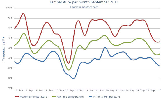
Thornton’s September this year was relatively benign and lacking much drama although it was a bit of a rollercoaster.  Temperatures had their large swings and we saw a couple of days with healthy precipitation.

The month started out slightly cooler than normal on the first but then warmed over the next couple of days to a high of 93.8 degrees on the third.

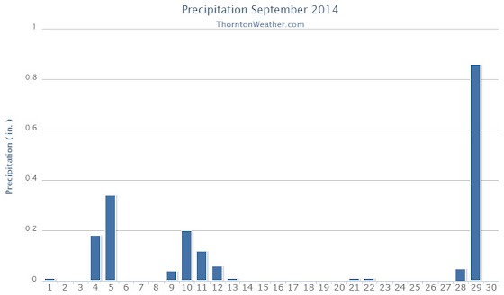
Low pressure and a cold front brought an end to the heat and three days of cooler than normal temperatures arrived.  Two of those three days combined to deliver more than a half inch of precipitation.

Warmer and drier weather returned for a few days before a more potent cold front pushed in.  The 11th and 12th of the month brought our coldest days of the month.  Low temperatures became quite chilly dropping to below freezing on the morning of the 13th as the system moved out.

Some rain fell on those days and while Denver recorded a trace of snow on the morning of the 12th, none was seen in Thornton.

We then rebounded nicely with 10 of the next 11 days seeing high temperatures above 80 degrees, many of those in the mid to upper 80s.

Things cooled down for the last three days as a strong system moved through.  We recorded a significant 0.86 inches of rain on the 29th.

Thornton’s overall average temperature for the month was 62.6 degrees.  This was a bit below the long term Denver average of 63.4 degrees.  Out at the airport, it was as usual warmer with an average of 64.8 degrees.

Temperatures ranged from a high of 93.8 degrees on the 3rd down to a chilly low of 30.9 degrees on the 13th.  Denver’s warmest day matched ours on the 3rd with a reading of 94 degrees while the Mile High City’s coldest reading of 33 degrees came on the 12th.

Denver saw one temperature record during the month.  The record high minimum for September 25th was set with a reading of 56 degrees.  This tied the record for the date last set in 1981.

In terms of precipitation, Thornton recorded 1.89 inches in the rain bucket for the month.  Denver saw 1.79 inches.  Both were well above Denver’s September average of 0.96 inches.

A daily rainfall record for Denver was set on the 29th when 1.01 inches fell at the airport.  The old record of 0.96 inch for the date was set in 1959.

Click here to view Thornton’s September 2014 climate report.

Thornton, Colorado’s September 2014 Temperature Summary. (ThorntonWeather.com)
Thornton, Colorado’s September 2014 Precipitation Summary. (ThorntonWeather.com)
...THE DENVER CO CLIMATE SUMMARY FOR THE MONTH OF SEPTEMBER 2014...

CLIMATE NORMAL PERIOD 1981 TO 2010
CLIMATE RECORD PERIOD 1872 TO 2014

WEATHER         OBSERVED          NORMAL  DEPART  LAST YEAR`S
                 VALUE   DATE(S)  VALUE   FROM    VALUE  DATE(S)
                                          NORMAL
................................................................
TEMPERATURE (F)
RECORD
 HIGH              97   09/06/2013
                        09/05/2013
                        09/04/1995
 LOW               17   09/29/1985
HIGHEST            94   09/03        91       3       97  09/06
                                                          09/05
LOWEST             33   09/12        35      -2       38  09/28
AVG. MAXIMUM     78.9              78.5     0.4     78.6
AVG. MINIMUM     50.6              48.3     2.3     54.2
MEAN             64.8              63.4     1.4     66.4
DAYS MAX >= 90      2               3.4    -1.4        7
DAYS MAX <= 32      0               0.0     0.0        0
DAYS MIN <= 32      0               0.8    -0.8        0
DAYS MIN <= 0       0               0.0     0.0        0 
PRECIPITATION (INCHES) 
RECORD
  MAXIMUM         5.61   2013
  MINIMUM            T   1892                         1944 
TOTALS           1.79              0.96    0.83     5.61 
DAILY AVG.       0.06              0.03    0.03     0.19 
DAYS >= .01         9               6.5     2.5       10
DAYS >= .10         4               3.3     0.7       10
DAYS >= .50         1               0.6     0.4        3
DAYS >= 1.00        1               0.1     0.9        2
GREATEST
 24 HR. TOTAL    1.01   09/29 TO 09/29           09/14 TO 09/15

SNOWFALL (INCHES)
RECORDS
 TOTAL             17.2   1991
TOTALS              T               1.3     -1.3       0

DEGREE_DAYS
HEATING TOTAL      91               125     -34       83
 SINCE 7/1         98               141     -43       83
COOLING TOTAL      88                76      12      133
 SINCE 1/1        701               764     -63      999

FREEZE DATES
RECORD
 EARLIEST     09/08/1962
 LATEST       06/08/2007
EARLIEST                        10/07
LATEST                          05/05
.....................................................

WIND (MPH)
AVERAGE WIND SPEED              9.4
RESULTANT WIND SPEED/DIRECTION   3/186
HIGHEST WIND SPEED/DIRECTION    33/350    DATE  09/09
HIGHEST GUST SPEED/DIRECTION    40/360    DATE  09/09

SKY COVER
POSSIBLE SUNSHINE (PERCENT)   MM
AVERAGE SKY COVER           0.50
NUMBER OF DAYS FAIR           13
NUMBER OF DAYS PC             11
NUMBER OF DAYS CLOUDY          6

AVERAGE RH (PERCENT)     55

WEATHER CONDITIONS. NUMBER OF DAYS WITH
THUNDERSTORM              3     MIXED PRECIP               0
HEAVY RAIN                1     RAIN                       6
LIGHT RAIN                9     FREEZING RAIN              0
LT FREEZING RAIN          0     HAIL                       0
HEAVY SNOW                0     SNOW                       0
LIGHT SNOW                2     SLEET                      0
FOG                       9     FOG W/VIS <= 1/4 MILE      1
HAZE                      3

-  INDICATES NEGATIVE NUMBERS.
R  INDICATES RECORD WAS SET OR TIED.
MM INDICATES DATA IS MISSING.
T  INDICATES TRACE AMOUNT.

September 2014 top shots: Monthly photo slideshow

September 3, 2014 - A pastel colored sunset in Thornton. (Michelle Jones)
September 3, 2014 – A pastel colored sunset in Thornton. (Michelle Jones)

The month of September is typically one of the more pleasant months in Colorado.  Temperatures are usually comfortable and there is not normally a lot of weather drama.  That however does not mean there aren’t plenty of photo opportunities.

Wildlife is still quite active along the Front Range and flowers will hold on to their petals for at least the first part of the month.  Then of course there is the weather which you never know what to expect.  Thunderstorms, heavy rain, and even snow are a possibility.

  • Slideshow updated October 1, 2014
  • To learn more about how to send your photo to us for inclusion in the slideshow, see below the slideshow.

Showcasing images captured by ThorntonWeather.com readers as well as some of our own, our monthly slideshow covers the entire gamut of weather-related imagery.

Sunsets, sunrises, wildlife and of course every type of weather condition are vividly depicted in images captured from yours and our cameras.

Click the play button below and sit back and enjoy the images.

What is missing in the slideshow above?  Your photo!

Our monthly photo slideshow is going to feature images that we have taken but more importantly images that you have captured.  The photos can be of anything even remotely weather-related.

Landscapes, current conditions, wildlife, pets, kids.  Whimsical, newsy, artsy.  Taken at the zoo, some other area attraction, a local park, a national park or your backyard.  You name it, we want to see and share it!

Images can be taken in Thornton, Denver or anywhere across the extraordinary Centennial State.  We’ll even take some from out of state if we can tie it to Colorado somehow.

We’ll keep the criteria very open to interpretation with just about any image eligible to be shown in our slideshows.

What do you win for having your image in our slideshow?  We are just a ‘mom and pop’ outfit and make no money from our site so we really don’t have the means to provide prizes.  However you will have our undying gratitude and the satisfaction that your images are shared on the most popular website in Thornton.

To share you images with us and get them included in the slideshow just email them to us or share them with ThorntonWeather.com on any of the various social media outlets.  Links are provided below.

So come on, get those camera’s rolling!

September snowfall in Denver not so unusual

September snow in Denver?  Possible and not at all unusual.
September snow in Denver? Possible and not at all unusual.

With a significant blast of cold air set to arrive this week, there is a chance for the Mile High City to see its first snowfall of the season.  While such an event would be the first September snow of this millennium, it would hardly be unusual.

Looking back at Denver’s snowfall records dating to 1882, 45 Septembers have recorded a trace or more of snowfall.  That means that out of 132 Septembers including this one, roughly one third of them have seen snow. Overall, the month averages 1.1 inches.

Of those 45 Septembers with snow, 17 were for only a trace.  Twenty eight, or roughly 21 percent, had measurable snowfall of 0.1” or more.

Denver’s heaviest 24 hour September snowfall came between September 24 and 25 in 1936 when a hefty 15.0 inches fell to the ground.  That snowfall contributed to 1936 taking its place as the second snowiest September on record.

For the entire month of September, some years saw rather significant totals.  The top 10 September snowfall totals include:

17.2 inches in 1971
16.5 inches in 1936
12.9 inches in 1959
11.4 inches in 1895
8.7 inches in 1985
7.4 inches in 1995
6.5 inches in 1908
5.8 inches in 1961
5.5 inches in 1965
5.4 inches in 1993

The earliest snowfall on record occurred on September 3, 1961.  On that date 4 inches of snowfall fell at the old Stapleton International Airport and the mercury dropped to a low of 33 degrees.

The last time Denver saw a September snow was on September 23, 2000 when 0.2 inches was recorded.

On average, we receive our first snow on October 19 so should snow fall, it will be well ahead of normal.

The cold that looks to come could very well bring an end to the growing season.  The Mile High City’s first frost on average comes on September 20th followed by the average first freeze on October 7.  Given that, a frost at the current time of the month is not that far off the mark.  It does not appear at this moment we will see that first freeze – yet – but a frost is possible.

Will September 2014 break the 13 year streak with no September snow?  Standby and check our forecast for the latest.

Thornton’s September weather preview: Usually one of our more pleasant months

Following on a cooler and wetter than normal August, the month of September arrives and one can’t help but wonder if an early fall lies in wait as well.  The month can bring our first snow of the season but more often than not, it is one of the most pleasant along the Colorado Front Range.
As temperatures start to drop, September usually reminds us that summer is at an end and fall is now here. Sunshine is predominant though as the month actually has the highest percentage of sun out of any month. Sunny days and clear, cool nights are the standard weather pattern for the month.

The month can bring extremes however.  We will of course forever remember last year’s devastating floods brought on by record-setting rain.  Longtime residents might remember September 1971 which brought over 17 inches of snowfall.

Get a complete look at September’s weather and more details as to what we can expect this year here.

September 28 to October 5: This Week in Denver Weather History

This Week In Denver Weather History
September 28 to October 5: This Week in Denver Weather History

While it appears Denver will escape September snow, our look back at this week in weather history shows that isn’t always the case. Additionally, while not common, even early fall can bring severe weather with damaging wind, lightning and even tornadoes.

From the National Weather Service:

28-29

In 1959…one of the heaviest September snow storms of record began as rain and changed to heavy wet snow. The storm caused heavy damage to trees and shrubbery…which were still in full leaf. The storm dumped 10.6 inches of snow at Stapleton Airport…the third heaviest September snow amount to date. Falling trees and limbs disrupted traffic…broke power and communication lines…and damaged buildings and cars. One man was killed in Denver by a falling tree limb…and four others died of heart attacks while shoveling snow or trying to move heavy tree limbs. Direct costs of the storm for cleaning up debris…repairing utility lines…and damage to buildings and other property across all of eastern Colorado were estimated to be over a half million dollars. The value of trees destroyed or damaged was estimated to exceed five million dollars. North-northeast winds gusted to 32 mph at Stapleton Airport on the 28th.

In 1985…an unusually cold air mass for this time of year settled over the area. Metro Denver received 8 to 12 inches of powdery snow. The 8.7 inches of snow that fell at Stapleton International Airport was the first measurable snow of the season and the city’s heaviest September snowfall since 1971. The snow caused flight delays of over 2 hours at Stapleton International Airport. I-70 was closed for a time west of Denver. Snow-laden tree limbs snapped over all of metro Denver…causing widespread power outages. Ten thousand people were without electricity for a time in Boulder. The morning of the 29th saw mid-winter temperatures along the Front Range. The temperature dipped to 17 degrees…the lowest temperature ever recorded in September in Denver. The high temperature of only 29 degrees on the 29th was a new record low maximum for the date and lowest ever recorded during the month of September. The low temperature of 21 degrees on the evening of the 28th set a new record low for the date. The cold weather persisted through the 1st with record minimum temperatures of 25 degrees set on the 30th and 27 degrees set on October 1st.

29

In 1966…a vigorous cold front moved thru metro Denver. North winds gusting to 51 mph kicked up billows of blowing dust…which briefly reduced the visibility to 1 mile at Stapleton International Airport. The cold air caused temperatures to drop rapidly from a high of 86 degrees to a low of 46 degrees by days end.

In 1985…the lowest temperature ever recorded in September… 17 degrees…occurred. The high temperature warmed to only 29 degrees…the all-time record low maximum for the month.

In 1994…the temperature reached a high of 91 degrees at Stapleton International Airport. This was the 60th day of the year that the temperature had reached 90 degrees or more…establishing a new record at that time. The previous record of 52 “90 degree days” occurred in 1978. Only 43 “90 degree days” were recorded at Denver International Airport during 1994.

In 1995…lightning struck a couple in Aurora as they were walking in the rain. The bolt struck the umbrella the man was carrying…injuring both the man and his wife.

In 2000…late afternoon thunderstorms produced strong wind gusts to 76 mph in Westminster…to 69 mph near Boulder…and to 60 mph at Jefferson County Airport near Broomfield. No damage was reported.

30

In 1898…south winds were sustained to 41 mph with gusts to 54 mph.

In 1940…a late season thunderstorm in the city caused one lightning death.

In 1944…the month ended with a trace of rain on this date and for the month. A trace of rain also occurred on the 4th…9th…and 10th. There was no measurable precipitation for the month. The total of a trace of precipitation for the month equaled the driest September on record first set in 1892.

In 2009…a trained spotter in Coal Creek Canyon…recorded a peak wind gust to 88 mph.

Continue reading September 28 to October 5: This Week in Denver Weather History

September 2013 weather recap: Above normal temps, record-setting rainfall

[pe2-image src=”http://lh3.ggpht.com/-s4FTglN9w8U/UjWvCPnJ1FI/AAAAAAAAAhU/VSkx7UO17jE/s144-c-o/006.jpg” href=”https://picasaweb.google.com/108306177534978229224/September2013ColoradoSFloods?authkey=Gv1sRgCOa7nK-5oPKyvQE#5923833337961108562″ caption=”South Platte River at 100th & McKay road breaching its banks and flowing into the Sprat Lakes on September 12, 2013. (Ed Dalton)” type=”image” alt=”006.jpg” pe2_single_image_size=”w300″ pe2_img_align=”right”  ]

As we close the books on September 2013, the month featured its usual variety of weather but there is only one thing it will be remembered for:  rain!

The month opened with temperatures well above normal.  In fact, Denver recorded high temperature records three times in the first seven days.

Soon after however, the picture changed dramatically.  The ridge that had kept us so warm at the start of the month moved east and low pressure remained over Nevada.  This allowed a monsoonal-type flow of moisture to settle in and remain stubbornly in place for days on end.

Heavy rain became the rule starting on the 9th with showers persisting for six of the next seven days.  Thornton and all of the Denver metro area recorded extraordinary amounts while areas closer to the foothills were absolutely pounded.

The ensuing floods were devastating for many places along rivers and streams.  Thornton weathered the storm relatively well with some minor flooding.  Other communities stretching from the foothills to the northeastern plains weren’t so lucky.

The month closed out with relatively typical September weather.  Most days were mild but there were a few more showers and some colder temperatures as well.

In terms of temperatures, Thornton saw a monthly average of 64.3 degrees.  This was almost a full degree warmer than the Denver long-term average of 63.4 degrees.  The Mile High City, as measured at DIA, was as usual a good bit warmer with a September 2013 average of 66.4 degrees.

Neither location was warm enough to make it into the list of top 10 warmest Septembers.  The number ten spot is 66.6 degrees.

We recorded 7 days with temperatures at or above 90 degrees.  This matched the number Denver recorded.

Thornton saw a high monthly temperature of 99.0 degrees and a low of 33.2 degrees.  Denver’s temperatures ranged from 97 degrees down to a low of 38 degrees.

Officially Denver recorded set or tied three record high temperatures:

  • September 5, 97 degrees, tied record high last set in 1899.
  • September 6, 97 degrees, breaks old record high of 95 degrees set in 1959.
  • September 7, 95 degrees, tied record high last set in 1933.

Precipitation was of course the big story for the month and Thornton saw more rain in the month than we have ever recorded at ThorntonWeather.com since coming online in October 2006.  By the time September came to a close, we had already bested our top year – with three months to go in 2013.

Thornton recorded a total of 10.15 inches of precipitation.  The majority of that, 8.84 inches, fell between the 9th of the month and the 15th.  One day, the 11th, dropped 4.76 inches in the rain bucket alone.

For Denver, we once again witnessed the problems with the official station being moved to Denver International Airport.  While they did record an abnormally high amount, it lagged other areas closer to town, including at the old Stapleton site.

Denver’s records will show 5.61 inches, well above the September normal of 0.96 inches.  That also is enough to put September 2013 into the history books as the wettest September in Denver history.  The old record holder was September 1961 with 4.67 inches.

Three daily precipitation records were set at DIA:

  • September 12, 1.11 inches, breaks old daily rain record of 0.95 inches set in 2012
  • September 14, 2.01 inches, breaks old daily rain record of 0.61 inches set in 1912
  • September 23, 0.64 inches, breaks old daily rain record of 0.52 inches set in 2000

No snow fell in September for the 13th year in a row.  This ties the record for the longest snow-less September streak with the periods from 1914 through 1926 and from 1882 to 1894.  The last time we saw September snow was in 2000 when 0.2” fell.  The month averages 1.3 inches.

Click here to view Thornton’s September 2013 climate summary report.

Looking back – Top stories from the September 2013 floods

[pe2-image src=”http://lh3.ggpht.com/-mk2_HTFl7bI/UktlyYkmEQI/AAAAAAAAAwY/a56KaoOMF0Q/s144-c-o/Sept-Temps.jpg” href=”https://picasaweb.google.com/108306177534978229224/Misc?authkey=Gv1sRgCNPjmpm5l5PSOA#5929945250627195138″ caption=”Thornton, Colorado September 2013 temperatures.” type=”image” alt=”Sept-Temps.jpg” pe2_single_image_size=”w560″ pe2_img_align=”none” ]

 [pe2-image src=”http://lh3.ggpht.com/-AEI7PqNjsFo/UktlyUJaioI/AAAAAAAAAwU/tglbcxtvlQo/s144-c-o/Sept-Precip.jpg” href=”https://picasaweb.google.com/108306177534978229224/Misc?authkey=Gv1sRgCNPjmpm5l5PSOA#5929945249439451778″ caption=”Thornton, Colorado September 2013 precipitation.” type=”image” alt=”Sept-Precip.jpg” pe2_single_image_size=”w560″ pe2_img_align=”none” ]

CLIMATE REPORT
NATIONAL WEATHER SERVICE BOULDER, CO
240 AM MDT TUE OCT 1 2013

......THE DENVER CO CLIMATE SUMMARY FOR THE MONTH OF SEPTEMBER 2013...

CLIMATE NORMAL PERIOD 1981 TO 2010
CLIMATE RECORD PERIOD 1872 TO 2013

WEATHER         OBSERVED          NORMAL  DEPART  LAST YEAR`S
                 VALUE   DATE(S)  VALUE   FROM    VALUE  DATE(S)
                                          NORMAL

TEMPERATURE (F)
RECORD
 HIGH              97   09/06/2013
                        09/05/2013
                        09/04/1995
 LOW               17   09/29/1985
HIGHEST            97R  09/06        97       0       95  09/01
                        09/05
LOWEST             38   09/28        17      21       45  09/28
                                                          09/22
AVG. MAXIMUM     78.6              78.5     0.1     80.3
AVG. MINIMUM     54.2              48.3     5.9     52.3
MEAN             66.4              63.4     3.0     66.3
DAYS MAX >= 90      7               3.4     3.6        7
DAYS MAX <= 32      0               0.0     0.0        0
DAYS MIN <= 32      0               0.8    -0.8        0
DAYS MIN <= 0       0               0.0     0.0        0 

PRECIPITATION (INCHES) 
RECORD 
 MAXIMUM         4.67   1961 
 MINIMUM            T   1892           
                        1944 

TOTALS           5.61R             0.96    4.65     2.95 
DAILY AVG.       0.19              0.03    0.16     0.10 
DAYS >= .01        10               6.5     3.5        5
DAYS >= .10        10               3.3     6.7        3
DAYS >= .50         3               0.6     2.4        3
DAYS >= 1.00        2               0.1     1.9        1
GREATEST
 24 HR. TOTAL    2.39   09/14 TO 09/15           09/25 TO 09/26
                                                          09/07 TO 09/07
                                                          09/07 TO 09/07
 STORM TOTAL       MM                                 MM
 (MM/DD(HH))            MM                    09/26(00) TO 09/26(00)
                                                 09/07(00) TO 09/07(00)7
                                                 09/07(00) TO 09/07(00)7

SNOWFALL (INCHES)
RECORDS
 TOTAL             MM   MM
TOTALS            0.0               1.3

DEGREE_DAYS
HEATING TOTAL      83               125     -42       69
 SINCE 7/1         83               141     -58       69
COOLING TOTAL     133                76      57      113
 SINCE 1/1        999               764     235     1235

FREEZE DATES
RECORD
 EARLIEST     09/08/1962
 LATEST       06/08/2007
EARLIEST                        10/07
LATEST                          05/05

WIND (MPH)
AVERAGE WIND SPEED              9.2
RESULTANT WIND SPEED/DIRECTION   2/183
HIGHEST WIND SPEED/DIRECTION    45/220    DATE  09/22
HIGHEST GUST SPEED/DIRECTION    64/220    DATE  09/22

SKY COVER
POSSIBLE SUNSHINE (PERCENT)   MM
AVERAGE SKY COVER           0.50
NUMBER OF DAYS FAIR            8
NUMBER OF DAYS PC             14
NUMBER OF DAYS CLOUDY          8

AVERAGE RH (PERCENT)     59

WEATHER CONDITIONS. NUMBER OF DAYS WITH
THUNDERSTORM              0     MIXED PRECIP               0
HEAVY RAIN                5     RAIN                       8
LIGHT RAIN               15     FREEZING RAIN              0
LT FREEZING RAIN          0     HAIL                       0
HEAVY SNOW                0     SNOW                       0
LIGHT SNOW                0     SLEET                      0
FOG                      12     FOG W/VIS <= 1/4 MILE      4
HAZE                      1

-  INDICATES NEGATIVE NUMBERS.
R  INDICATES RECORD WAS SET OR TIED.
MM INDICATES DATA IS MISSING.
T  INDICATES TRACE AMOUNT.

Video captures virtually impassable US 34 near Drake following flooding

[pe2-image src=”http://lh4.ggpht.com/-ay57f6lobfs/Uki4iBmH3II/AAAAAAAAAv0/-rN3zB9mnJw/s144-c-o/co-drake.jpg” href=”https://picasaweb.google.com/108306177534978229224/September2013ColoradoSFloods?authkey=Gv1sRgCOa7nK-5oPKyvQE#5929191804116655234″ caption=”US.34 near Drake is siimply no longer in existence in the wake of the flooding. Image taken September 28, 2013. (Loveland Fire Rescue Authority)” type=”image” alt=”co-drake.jpg” pe2_single_image_size=”w300″ ]

Recovery following Colorado’s devastating floods will be a painstaking process that takes months and years.  New video showcases one, small part of the destruction but serves as a reminder as to just how extensive the damage is.

US Highway 34 between Loveland and Estes Park is no stranger to flood damage.  Once again, the canyon areas were among the hardest hit in the state and the highway was entirely destroyed in many locations.

Personnel with the Loveland Fire Rescue Authority rode an ATV up the canyon to near Drake this past Saturday, September 28, 2013, and recorded it on video using a helmet mounted camera.  The highway is impassable by car and one of the areas that required extensive aerial rescues to help residents stranded by the flood waters.

Entire sections of the road are destroyed as the rider is forced to evade downed power lines and scattered debris.  At one point, he appears to be riding in the river but instead is riding where there used to be a highway.

The three-minute video is well worth watching.

Gorgeous Colorado sunrise follows early morning crescent moon (Photos)

One of the benefits of being early risers like we are is that we oftentimes get to see what many others sleep through.  Those that had their eyes closed just before the sunrise and as it came up, missed quite a show.  Here are a few shots we took this morning.

[pe2-image src=”http://lh4.ggpht.com/-Li1oR3QnB5M/Ukh9XPB3CJI/AAAAAAAAAvU/sc3NElEWgcM/s144-c-o/twe1.jpg” href=”https://picasaweb.google.com/108306177534978229224/09292013MoonAndSunrise#5929126747558054034″ caption=”A pre-dawn crescent moon started the morning’s show. (ThorntonWeather.com)” type=”image” alt=”twe1.jpg” pe2_single_image_size=”w580″ pe2_img_align=”none” ] [pe2-image src=”http://lh5.ggpht.com/-6addX2X_SQA/Ukh9XOH4_3I/AAAAAAAAAvM/FQIPjtF-0qI/s144-c-o/twe3.jpg” href=”https://picasaweb.google.com/108306177534978229224/09292013MoonAndSunrise#5929126747314913138″ caption=”Old Glory and a gorgeous Colorado sunrise – it doesn’t get much better than that. (ThorntonWeather.com)” type=”image” alt=”twe3.jpg” pe2_single_image_size=”w580″ pe2_img_align=”none” ] [pe2-image src=”http://lh3.ggpht.com/-P0xuLDep-Lc/Ukh9XMaqy7I/AAAAAAAAAvQ/D3uQw9rSZmc/s144-c-o/twe2.jpg” href=”https://picasaweb.google.com/108306177534978229224/09292013MoonAndSunrise#5929126746856803250″ caption=”The sky was bathed in orange and blue at the start of the day. (ThorntonWeather.com)” type=”image” alt=”twe2.jpg” pe2_single_video_size=”w400″ pe2_gal_align=”none” pe2_img_align=”none” ]

That isn’t clouds on Tuesday morning’s satellite imagery

This morning’s satellite imagery runs are showing some interesting white cover on Colorado’s landscape and it isn’t clouds.  In fact, we see virtually entirely cloudless skies across the state.

That white stuff is in fact snow, the first covering of the season at higher elevations.  Some locations Sunday night / Monday morning received up to six inches of the white stuff.

Satellite imagery clearly shows the snow in parts of the San Juan Mountains to the southwest as well as the Elk and Sawatch ranges, the Flat Tops and even the western parts of the Front Range mountain areas.

It likely won’t be long before the Front Range sees its own snowfall.  Denver’s first freeze on average occurs on October 7th.  Its first snowfall on October 19th.

More Denver cold weather statistics can be found here.