This morning’s satellite imagery runs are showing some interesting white cover on Colorado’s landscape and it isn’t clouds. In fact, we see virtually entirely cloudless skies across the state.
That white stuff is in fact snow, the first covering of the season at higher elevations. Some locations Sunday night / Monday morning received up to six inches of the white stuff.
Satellite imagery clearly shows the snow in parts of the San Juan Mountains to the southwest as well as the Elk and Sawatch ranges, the Flat Tops and even the western parts of the Front Range mountain areas.
It likely won’t be long before the Front Range sees its own snowfall. Denver’s first freeze on average occurs on October 7th. Its first snowfall on October 19th.
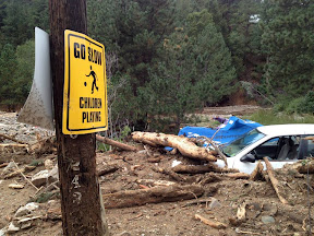
Damage in Jamestown on September 15, 2013. See the map of rainfall totals from the flooding event below. Click the image to view a photo slideshow of the devastation. (Boulder OEM)
By the numbers, the rainfall experienced across northeastern Colorado since Monday, September 9 has been nothing short of extraordinary. Over the span of a week, many locations received half of what they normally receive in an entire year. Some received more than what they expect annually.
We have created and interactive map (below) that shows precipitation totals from Monday, September 9, 2013 to Monday, September 16, 2013. The numbers are totals as reported by CoCoRaHS volunteers – the Community Collaborative Rain, Hail & Snow Network.
Looking at the map, it is clear that the Boulder area received the most with one station recording an astonishing 21.13” over the 7 day timespan. The official station in Boulder has recorded 16.69” inches this month and 29.65” for the year. These numbers break Boulder’s monthly record and its annual precipitation record.
Denver’s official station at Denver International Airport (DIA) has recorded 4.65 inches this month, enough to put September 2013 in the books as the 2nd wettest on record. However, that total hardly reflects what locations closer to the city’s center received with many recording over 7” this month.
Here in Thornton we have seen 8.85” of rain so far this month, an extraordinary total that brings our total for 2013 to 18.81”. This is clearly the biggest month and year for precipitation since ThorntonWeather.com came online in 2007 and likely the biggest month ever in Thornton.
Don’t miss a thing when it comes to our ever-changing weather! Be sure to ‘like’ us on Facebook, follow us on Twitter and add us to your Google+ circles.
The start of meteorological fall has been highly eventful with record-setting high temperatures followed by virtually unprecedented rainfall. Four days of steady, sometimes heavy, rain has created hazardous conditions in many places along the Colorado Front Range including Thornton.
We will be monitoring monitoring the storm very closely and posting regularly to our Facebook page and Twitter feed. You can follow along in real time below. We are also on Google+ here.
This image from the Suomi NPP satellite’s VIIRS sensor from the evening of September 11, 2013, shows the storm system that has devastated towns in the foothills of the Rockies in central Colorado. Flash Flood Watches and Warnings are in effect throughout central Colorado, citing excessive runoff causing flash flooding of creeks and streams, roads and roadside culverts. The heavy rains could also trigger rock slides or debris flows in steep terrain. Major amounts of rain over the last several days have saturated soils in many foothill and Urban Corridor locations and additional rainfall in these locations today and tonight will only exacerbate an already serious situation. The High Park and Four Mile burn areas will be especially susceptible to the heavy rains. This image was taken around 2015Z on September 11, 2013. (NOAA)
* Click the image above for a larger view
Five days of rain, one with absolutely torrential downpours, created dangerous and deadly flooding across much of the Colorado Front Range. At one point the National Weather Service warned of ‘biblical rainfall amounts’ and it became hard to argue with that terminology. The rainfall amounts were truly astounding.
Boulder, where some of the worst flooding was seen, recorded 9.08” on Thursday, September 12. Estes Park, where the Big Thompson River flooded its banks, saw 3.9” over the 24 hour period.
Officially Denver only saw 1.1” on the date but that was as measured at Denver International Airport which only saw the edge of the storms. At the previous historical location in Stapleton, 3.68” was measured.
Here in Thornton we seemed to be right in line for the storms and generated one of the higher totals in the metro area accumulating 4.76” on the date. Since the rain started five days ago, we have received an amazing 7.66” (as of this writing).
Don’t miss a thing when it comes to our ever-changing weather! Be sure to ‘like’ us on Facebook, follow us on Twitter and add us to your Google+ circles.
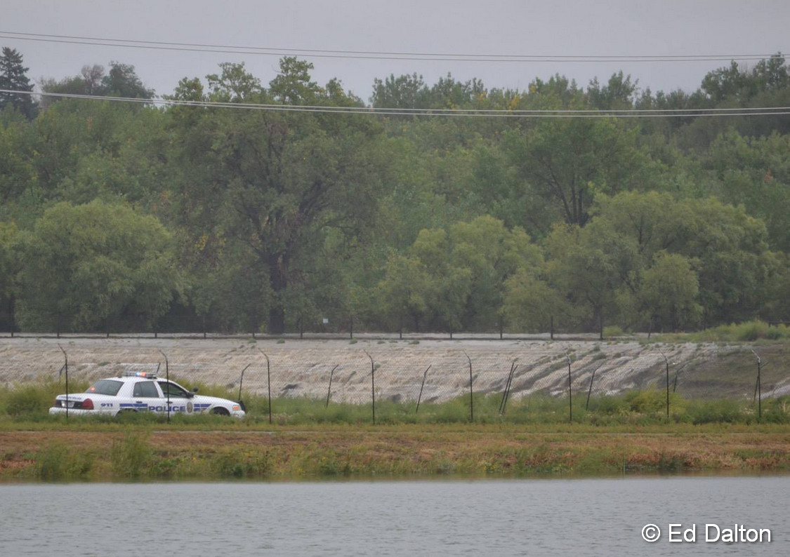
Water flows over the banks of the South Platte River into Sprat-Platte Lake near Thornton on the afternoon of September 12, 2013. Click for a larger view. (Ed Dalton)
What has been called a 100-year storm and even referred to as being of ‘biblical’ proportions is very slowly coming to an end. The worst of the rain fell on Thursday, September 12 with locations in Colorado’s foothills reporting in excess of 8 inches of rainfall.
Among the hardest hit areas were the college town of Boulder and picturesque Estes Park. Both cities have seen extensive flooding and damage totals across the state will be well into the tens, if not hundreds, of millions of dollars.
The two videos below capture the raging waters as they pummeled the communities.
The first video shows Boulder as well as some commentary by Gov. John Hickenlooper. The second is of downtown Estes Park.
Don’t miss a thing when it comes to our ever-changing weather! Be sure to ‘like’ us on Facebook, follow us on Twitter and add us to your Google+ circles.
This year on September 3 Denver reached an official high temperature of 94 degrees. Here in Thornton we topped out at 95 degrees.
Providing a stark contrast is a look back at this date 52 years ago.
On September 3, 1961 a winter-like system delivered 4.2 inches of snow to the Mile High City with the foothills receiving a foot of the white stuff. This is the earliest date for a seasonal snowfall on record. Temperatures that day dropped to 33 degrees, the earliest in the season it has ever been that cold.
The comparison highlights the extremes that Colorado can experience in September (much like most other months). Which would you prefer? Heat or snow?
Thornton saw yet another month with above normal temperatures during the month of September 2012. The one saving grace was that it was also a wet one with above normal precipitation.
The month started out with three out of the first six days of the month recording temperatures above 90 degrees and the other three warming to above 85 degrees.
Cooler weather arrived on the 12th and Thornton saw a high of only 59.6 degrees. Rain began late on the 11th and continued into the 12th as we recorded 1.32 inches of precipitation in our bucket during the period. Denver officially recorded 0.95 inch on the 12th which was a record for the date.
Above normal temperatures soon returned however and overall we recorded 15 days of high temperatures of at least 80 degrees during the month.
Another storm system moved in on the 25th and 26th and brought more precipitation. Thornton recorded 0.81 inch during the period. At Denver International Airport 1.95 inch was recorded over the two day period. On the 26th alone the airport recorded 1.41 inches, a record for the date.
The average temperature for the month was 64.0 degrees in Thornton. DIA averaged 66.3 degrees which was 2.9 degrees above normal.
Temperatures in Thornton ranged from a high of 94.6 degrees on the first down to a low of 41.6 degrees on the 18th. Denver saw its warmest temperature of 95 degrees on the 1st as well and its lowest of 45 degrees on the 22nd and 28th.
Thornton ended the month with a welcome 2.17 inches of precipitation. Denver fared better with 2.95 inches, well above the September normal of 0.96 inch. Officially the month went into the books as the 5th wettest October on record in Denver.
For the 12th consecutive September no snow was recorded in Denver. The last time we went such a long period without September snow was from 1914 to 1926.
...THE DENVER CO CLIMATE SUMMARY FOR THE MONTH OF SEPTEMBER 2012...

CLIMATE NORMAL PERIOD 1981 TO 2010
CLIMATE RECORD PERIOD 1872 TO 2012

WEATHER         OBSERVED          NORMAL  DEPART  LAST YEAR`S
                 VALUE   DATE(S)  VALUE   FROM    VALUE  DATE(S)
                                          NORMAL
................................................................
TEMPERATURE (F)
RECORD
HIGH               97   09/01 1995
                        09/04/1995
                        09/05/1899
 LOW               17   09/29/1985
HIGHEST            95   09/01        97      -2       96  09/01
LOWEST             45   09/28        17      28       38  09/21
                        09/22
AVG. MAXIMUM     80.3              78.5     1.8     78.6
AVG. MINIMUM     52.3              48.3     4.0     49.9
MEAN             66.3              63.4     2.9     64.2
DAYS MAX >= 90      7               3.4     3.6        1
DAYS MAX = .01         5               6.5    -1.5        6
DAYS >= .10         3               3.3    -0.3        2
DAYS >= .50         3               0.6     2.4        1
DAYS >= 1.00        1               0.1     0.9        0

GREATEST
 24 HR. TOTAL    1.63   09/25 TO 09/26

SNOWFALL (INCHES)
RECORDS
TOTAL             0.0
TOTALS            0.0               1.3

DEGREE_DAYS
HEATING TOTAL      69               125     -56       95
 SINCE 7/1         69               141     -72       95
COOLING TOTAL     113                76      37       78
 SINCE 1/1       1235               764     471      941

FREEZE DATES
RECORD
 EARLIEST     09/08/1962
 LATEST       06/08/2007
EARLIEST                        10/07
LATEST                          05/05
......................................................

WIND (MPH)
AVERAGE WIND SPEED              8.8
RESULTANT WIND SPEED/DIRECTION   3/197
HIGHEST WIND SPEED/DIRECTION    30/300    DATE  09/01
HIGHEST GUST SPEED/DIRECTION    37/290    DATE  09/01

SKY COVER
POSSIBLE SUNSHINE (PERCENT)   MM
AVERAGE SKY COVER           0.50
NUMBER OF DAYS FAIR           10
NUMBER OF DAYS PC             16
NUMBER OF DAYS CLOUDY          4

AVERAGE RH (PERCENT)     40

WEATHER CONDITIONS. NUMBER OF DAYS WITH
THUNDERSTORM              5    MIXED PRECIP                0
HEAVY RAIN                2     RAIN                       2
LIGHT RAIN                7     FREEZING RAIN              0
LT FREEZING RAIN          0     HAIL                       1
HEAVY SNOW                0     SNOW                       0
LIGHT SNOW                0     SLEET                      0
FOG                       6     FOG W/VIS
September 29 to October 6 - This Week in Denver Weather History
Our look back at this week in Denver weather history shows what has historically been a relatively quiet week. However that isn’t to say there aren’t events of note including days with severe thunderstorms, including one date that brought multiple tornadoes.
Be sure to scroll down to the bottom to check out video of one of the tornadoes that struck near Brighton on October 4, 2004.
From the National Weather Service:
30
In 1898…south winds were sustained to 41 mph with gusts to 54 mph.
In 1940…a late season thunderstorm in the city caused one lightning death.
In 1944…the month ended with a trace of rain on this date and for the month. A trace of rain also occurred on the 4th…9th…and 10th. There was no measurable precipitation for the month. The total of a trace of precipitation for the month equaled the driest September on record first set in 1892.
In 2009…a trained spotter in Coal Creek Canyon…recorded a peak wind gust to 88 mph.
30-1
In 1959…heavy snowfall totaled 5.9 inches at Stapleton Airport. Winds were light.
1
In 1892…the highest temperature ever recorded in October… 90 degrees…occurred. This is also the latest 90 degree reading of the season.
In 1898…southwest winds were sustained to 40 mph with gusts to 49 mph in the city.
In 1927…a trace of snow was the only snow of the month… Ranking the year…amongst several other years…the second least snowiest on record.
In 1971…a wind gust to 90 mph was recorded at Buckley Field in Aurora. The severe winds caused damage in northeast metro Denver. A brick wall of a bowling alley was blown down…the roof was blown off a garage…and some business signs were damaged. A man in the bowling alley was injured by flying glass. Northwest winds gusted to 43 mph at Stapleton International Airport.
In 1994…unusually strong thunderstorms for so late in the season pummeled metro Denver with large hail. The largest hail…2 inches in diameter…fell at Buckley Field. Hail 1 3/4 inches in diameter fell 7 miles northeast of Boulder and at Niwot. Hail 3/4 to 1 1/2 inches in diameter fell in Boulder…Arvada…wheat Ridge…Edgewater…capitol hill and northwest Denver…Bennett…and Strasburg. Hail of unknown size damaged a Boeing 737 aircraft and injured both pilots at Stapleton International Airport when the windshield was broken out on takeoff. Half inch diameter hail fell at Stapleton International Airport where northwest winds gusted to 40 mph and rainfall totaled 0.82 inch.
In 2009…strong downslope winds near the foothills produced a peak wind gust to 84 mph at the national wind technology center near Rocky Flats.
Severe weather more typical of June than late September hit Colorado yesterday.
September weather in Colorado is typically tranquil and one of the more pleasant months in the state. This week however that wasn’t the case, especially yesterday when severe thunderstorms rumbled across the parts of the state.
Tuesday and Wednesday brought heavy rains to parts of the northern Front Range. The precipitation was welcomed as it provided much-needed relief from the recently dry conditions.
Yesterday in Colorado Springs and La Junta thunderstorms brought hail that accumulated up to 6 inches deep. Mother Nature however held more surprises as she brought tornadoes to other parts of the state.
Three tornadoes were reported in northeastern Colorado – one each in Adams, Douglas, and Weld counties. None of the three caused any damage.
A fourth twister however occurred in southern Colorado near Del Norte in Rio Grande County northwest of Alamosa. Local resident Julie Sauvigne captured amazing video of the tornado as it ripped through her property causing EF0 level damage to her home.
Watch the video below. Notice how the visible funnel is almost directly above Sauvigne while the circulation on the ground was occurring in a field nearly a mile away!
September 23 to September 29 - This Week in Denver Weather History
While typically the last week of September is calm, that isn’t always the case. In our look back at this week in Denver weather history we see damaging wind, dangerous lightning and September’s biggest snowfall on record in the Mile High City.
From the National Weather Service:
23
In 1873…north to northwest winds blowing almost a gale spread clouds of dust and sand into the city during the afternoon and evening. From the roof of the weather observer’s building…houses a few hundred yards away were not visible and not even the sky could be seen through the clouds of sand. The wind reached sustained speeds of 35 mph…but only 28 mph was registered for any one hour.
In 1977…wind gusts from 50 to 80 mph were reported along the foothills. A northwest wind gust to 53 mph was recorded at Stapleton International Airport.
23-24
In 2000…the first snowstorm of the season brought heavy snow to areas in and near the foothills. While the heaviest snow fell north of metro Denver…6 inches were measured in Boulder…4 inches at both Castle Rock and Morrison…but only 0.2 inch at the site of the former Stapleton International Airport where most of the precipitation fell as rain. At Denver International Airport where drizzle and rain fell on the 23rd… Snowfall during the early morning of the 24th was estimated at 2.1 inches due to melting. The foothills west of Denver received more snow with 10 inches measured at conifer…9 inches 11 miles southwest of Morrison… 8 inches atop Crow Hill…7 inches at Chief Hosa…and 5 inches at Ralston Reservoir.
24
In 1901…northwest winds were sustained to 50 mph with gusts as high as 57 mph in the city.
In 1932…thunderstorm rainfall of only 0.11 inch was the only measurable precipitation for the month that year in the city.
In 1986…a very strong wind storm roared across metro Denver. Boulder was hit hardest. Winds peaked to 131 mph at the National Center for Atmospheric Research. This is thought to be the highest wind gust ever recorded in Boulder during September. A wind gust to 118 mph was clocked on Davidson Mesa and to 92 mph near Niwot. Gusts of 70 to 80 mph were common over all of Boulder where an estimated 70 to 90 large trees were uprooted. About a dozen of them hit cars. Two walls of a building under construction were toppled and solar panels were blown off a house. Traffic lights and power lines were downed. Damage to power equipment alone was estimated at 100 thousand dollars. Wind gusts to 87 mph at Jefferson County Airport damaged two planes. A woman was seriously injured in Boulder. She suffered a fractured skull when struck by a falling tree limb. Trees were also downed in Louisville and Lafayette. West wind gusts to 45 mph were recorded at Stapleton International Airport.

 The start of meteorological fall has been highly eventful with record-setting high temperatures followed by virtually unprecedented rainfall. Four days of steady, sometimes heavy, rain has created hazardous conditions in many places along the Colorado Front Range including Thornton.
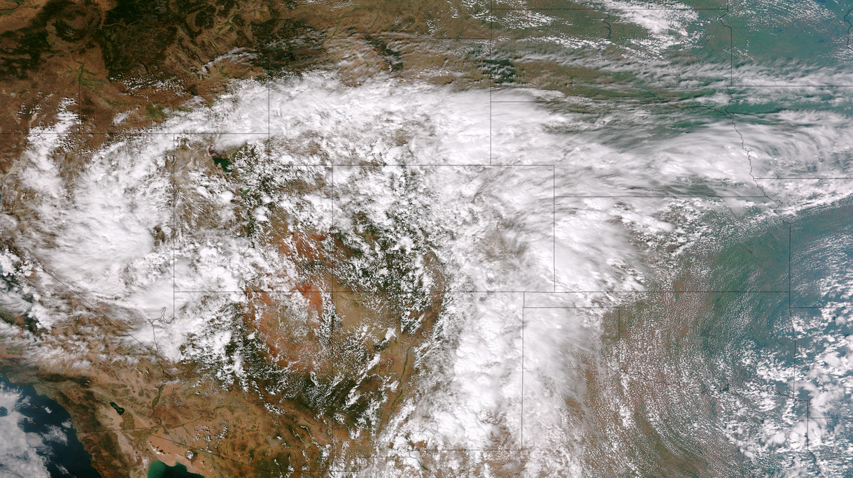
")


