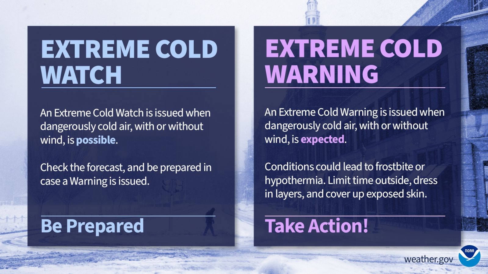
National Weather Service extreme cold watch and warning.
Wind chill watches, warnings and advisories are now a thing of the past. The National Weather Service has announced that in an effort to simplify the message these products are meant to convey, they will instead me called “Extreme cold” watches, warnings and advisories.
Hazard Simplification project seeks to simplify weather messaging
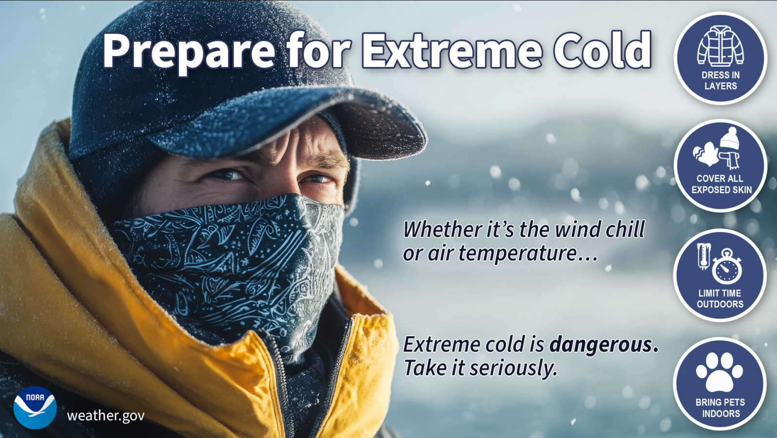
Cold weather can be deadly – people exposed to extreme cold are susceptible to frostbite and can succumb to hypothermia in minutes. So as we prepare for the frigid wind chills and sub-freezing temperatures that winter can bring, NOAA’s National Weather Service is simplifying a suite of cold weather forecast products to improve messaging of winter hazards and provide better decision support.
This effort is part of the Hazard Simplification initiative which integrates public and partner engagements and social science research to improve and evolve our alerting system.
The following changes will take place on Oct. 1:
Extreme Cold Consolidation and Renaming
Wind Chill Watches will be renamed to an Extreme Cold Watch
Wind Chill Warnings will be renamed to an Extreme Cold Warning
Wind Chill Advisory will be renamed a Cold Weather Advisory
Freeze Consolidation
Hard Freeze Watches will be renamed to a Freeze Watch
Hard Freeze Warnings will be consolidated to a Freeze Warning
These changes seek to clarify that cold can be dangerous with or without wind, addressing a common misconception that extreme cold is only tied to colder temperatures when there is wind. Dangerously cold weather can accompany or follow wintry precipitation, and the cold messaging can be overshadowed by the wintry precipitation.
Prepare for Extreme Cold. (National Weather Service)
The Wireless Emergency Alerts (WEA) system takes the system into the 21st century giving targeted alerts for weather, natural disasters, AMBER alerts and even alerts from the President of the United States.
Live CDOT webcam image from 120th & I-25 looking south.
Update, 6:10pm: As the storm starts to move to the east, blizzard conditions on the plains east of Denver are causing problems. I-70 remains closed from Airpark Road to Burlington and I-76 is closed from Lochbuie to Fort Morgan. Storm reports indicate blizzard conditions prevail with limited visibility and drifting snow. A Blizzard Warning is in effect for much of the northeastern Colorado plains and will remain so until 6:00am Friday.
Closer to town, things are finally starting to ease up along the Front Range and in the metro area. Gusty winds and cold temperatures will keep wind chills down into the teens and make it uncomfortable to be outside. Drifting snow on roadways is possible thanks to those gusty winds from the north. Additional light snow can be expected, mainly in areas to the west and south.
The Winter Storm Warning for the metro area was allowed to expire at 6:00pm as planned. However, roads are likely to get slick as temperatures drop overnight so please use caution.
Update, 12:38pm: October 2009 enters the record books as the 7th snowiest October on record in Denver. The National Weather Service reported that as of 6:00am today, the official station at Denver International Airport had recorded 14.5 inches of snow fall for this month. 10.6 inches of that had fallen in the previous 24 hours. With the early measurement and the fact the snow is expected to continue throughout the day, it is possible the month will climb further up the charts (see below).
It is also notable that Denver will likely finish the month as one of the coldest Octobers on record. Thus far the average temperature for October 2009 has been 43.9 degrees. Were the month to end today, that would place it in a tie for the third coldest October on record.
Update, 10:35am: The snow keeps falling! Light snow will continue across the urban corridor for the rest of the morning with 1 to 4 inches additional accumulation possible. Some areas south may see heavier snow rates, particularly to the south and east.
Blizzard-like conditions are possible in open areas where there is a good bit of wind blowing. Travel to the east is best avoided at this time due to low visibility and icy conditions. Chain laws are actually in effect on I-76 at Wiggins due to hazardous conditions. I-25 remains closed from Wellington to the Wyoming border.
At Denver International Airport, flight delays continue to mount. Delays of 3 to 4 hours are being experienced for arrivals and departures as DIA ground crews struggle to keep up with the falling snow. Frontier Airlines reports that additional cancelations are possible.
Storm spotters have reported amounts as high as 44 inches in Coal Creek Canyon and snowfall reaching near 3 feet is being seen in many places in the foothills. Closer to town, west and south are reporting up to 18 inches while central Denver is reporting close to one foot. ThorntonWeather.com has recorded 14.1″ so far! Click here for the latest storm reports from across the area.
ThorntonWeather.com is of course your source for local information on the storm as it develops. We will also be updating the Denver Weather Examiner site as things develop. Here are some quick links to pages you may find handy:
Update, 6:35am, Thursday, October 29, 2009: Thornton and a large portion of Colorado continue to be hammered by a two-day long storm that has dumped more than two feet of snow in the adjacent foothills and a foot across much of the metro area. At ThorntonWeather.com we have recorded 13.2 inches of snow thus far for the event. While the early winter storm has created its share of problems, the relatively slow snowfall rate has allowed it to be manageable by most standards.
The entire eastern half of Colorado is under a Red Flag Warning through Friday evening.
The National Weather Service has updated the Red Flag Warning and it will now go into effect at 9:00am today and run through 9:00pm. Further, the warning now covers the entire eastern half of the state of Colorado and in fact extends to the south and east into parts of Nebraska, Kansas, Oklahoma, Texas and New Mexico. This of course covers the entire Denver metro area and the Front Range.
The extension and widening of the warning should serve to really drive home how dry things are and how serious the fire conditions are. Please be sure to take appropriate precautions as we certainly would like to avoid any wildfires.
RED FLAG WARNING
NATIONAL WEATHER SERVICE DENVER CO
456 AM MST FRI FEB 6 2009
…Dry and windy conditions across the plains and lower foothills today…
Very dry air will combine with strong winds to produce increased fire danger over the foothills and plains of northeast Colorado today. Winds will gust as high as 40 mph on the plains this afternoon with gusts to 50 mph in the foothills. Minimum humidities will range from 10 to 15 percent. Conditions will improve on the plains around sunset…with warm and breezy conditions lingering in and near the foothills through the early evening hours.
…Red Flag Warning now in effect from 9 am this morning to 9 pm mst this evening for gusty winds and low humidities…
The Red Flag Warning is now in effect from 9 am this morning to 9 pm mst this evening. A Red Flag Warning is now in effect for all of the plains and foothills areas of eastern Colorado… Including fire weather zones 235…236…and 238 through 251.
West winds of 20 to 35 mph will become widespread in and near the southern Front Range foothills this morning…and spread across the plains by afternoon. Gusts as high as 50 mph are possible in the foothills. Relative humidities will drop into the 8 to 15 percent range. The combination of the gusty winds…low humidities and dry fuels will create very high fire danger. The gusty winds will decrease and the relative humidities will increase this evening.
A Red Flag Warning means that critical fire weather conditions are either occurring or imminent. Please advise the appropriate officials and fire crews in the field of this Red Flag Warning.
What does that warning mean? Knowing what the various advisories mean is important part of winter weather preparedness.
We all are familiar with the crawls on the TV screen or the announcements on the radio for winter weather advisories such as Winter Storm Watch, Blizzard Warning, Freeze Warning and more. But, how many of us really know what those mean? There is very specific criteria the National Weather Service follows in issuing these watches and warnings and there are important differences between all of them.
The National Weather Service will inform you about critical weather with outlooks, watches, warnings and advisories. Do you know what they mean? Now is the time to find out during this Colorado winter preparedness week.
This list has the watch, warning and advisory criteria for Colorado east of the continental divide. Save this list throughout the winter.
It is official – we have broken Denver’s 107 year old record of consecutive days with over 90 degree temperatures. Thursday marked day 19 in the streak, moving past the old record of 18 days set way back in 1901 and 1874.
At the current time, it looks like the 90+ degree heat will continue until Wednesday at the earliestso the streak could number around 24 days or so by the time it is done. Thornton’s forecast calls for 101 degrees Friday, 100 Saturday and 98 on Sunday so the weekend will be a hot one for sure. This gives us the potential to break Denver’s all-time record for August 1st and 2nd of 100 degrees (set in 1938 and 1878 respectively). Thankfully it doesn’t look like we will break the overall all-time Denver temperature record of 105 so you can consider that a bit of a silver lining. 🙂 Continue reading Record streak official. Heat Advisory and possible record temps to come.→
We just read on KMGH channel 7’s website that all Front Range area King Soopers are offering a very good deal on a Midland WR-100 radio. These are similar to the WR-300 model we discussed previously – just with fewer bells and whistles. The WR-100 retails for $49.99 but through September at area King Soopers stores you can buy one for $29.99.
 system takes the system into the 21st century giving targeted alerts for weather, natural disasters, AMBER alerts and even alerts from the President of the United States.")


 It is official – we have broken Denver’s 107 year old record of consecutive days with over 90 degree temperatures. Thursday marked day 19 in the streak, moving past the old record of 18 days set way back in 1901 and 1874.
 We just read