We happened across this video recently and had to share it. Photographer Jason Hatfield is a transplant to Colorado and has spent recent years filming our fall foliage. The end result? An amazing compilation of the high country in autumn.
From Jason’s description:
For the 8 years I’ve lived in Colorado, I’ve been most enthralled by the short but incredible fall foliage season in the high country. I’ve experienced the magnificent autumn colors of the East Coast and Midwest, but nothing for me has compared to the scenes of massive mountains rising from stunning forests of gold-covered aspens. For the past 5 years of filming, I’ve had this moment in my head, a finished time-lapse piece that turns Colorado’s extraordinary fall landscapes into living art. Some years I only came away with a couple good sequences, others a lot more, and finally after this season I felt I had the work I needed to produce my vision. Please enjoy this short film that embodies everything I love about my state.
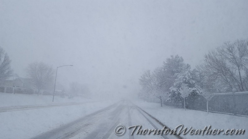
Mother Nature played a somewhat cruel trick on the Colorado Front Range. The week started with mild temperatures and a definite feeling of spring in the air. She closed out the week with a significant snowstorm and plenty of cold.
The long-expected storm arrived on the evening of Friday the 15th with rain. Overnight into the early morning of the 16th, the rain continued, heavy at times. In the early morning hours, as temperatures dropped, the rain changed to snow and would continue virtually non-stop through the morning of the 17th.
Thornton’s snowfall totals were certainly at the lower end of what was reported in the Denver metro area. We saw 7.3 inches, much of which melted as fast as it fell. Other locations not far to the west and south were pushing a foot and locations in the foothills and Palmer Divide saw nearly two feet.
The time lapse video begins at midnight on the morning of the 16th and continues through noon on the 17th.
The morning of March 23, 2016 saw the blizzard hit with full force. (ThorntonWeather.com)
It is hard to believe so much snow can fall over such a short period of time. Over just more than 12 hours Thornton received 21.7 inches – our biggest snowstorm since 2006. Our east facing webcam captured all the action from start to finish.
The video below starts at midnight on the 23rd with dry conditions. By about 2:00am rain falls but that quickly transitions to snow.
It is after daybreak that the storm gets started in earnest and the heavy snowfall almost entirely obscures the view at points. As is typical in Colorado, by mid-afternoon, we actually start to see some blue skies.
The video covers 19 hours in about 39 seconds. There are a few ‘hiccups’ in the video that you might notice. These were when we had brief power outages.
To say the storm that pounded the Colorado Front Range was a big one does not do it justice. In less than 24 hours Thornton would see blizzard conditions and our second heaviest snowfall of the previous 10 years.
Light rain began in the early morning hours but that soon transitioned to snow. The white stuff would continue to fall into the evening. Strong winds helped whip the snow and create blizzard conditions grinding the Colorado Front Range to a halt.
Thornton would tally 20.1 inches of snow, one of the heftier totals from the area.
The video below begins at midnight and runs through 7:00pm.
A fast-moving storm brought a quick shot of snow to the Denver metro area on Veterans Day. This time lapse video captures the snow just as it starts at 1:00am on November 11, 2015 and runs until 1:00pm that same day but which time the sun had come out and the snow was quickly melting. Thornton, Colorado recorded 4.1 inches from the storm.
The past week or so has brought quite a variety of weather, most notably seven straight days of precipitation. On Saturday we saw a continuation of the rain which changed to snow overnight, an event captured by one of our webcams.
Over the seven days, Thornton recorded a whopping 4.34 inches of liquid precipitation. Most of that fell as rain but 5.1 inches of snow provided some of that as well.
The video below shows the period from 3:00pm on Saturday, May 9 through 5:00pm on Sunday, May 10 compressed to about 53 seconds. It starts with rain which soon transitions to snow as the evening arrives. The snow continues into the following morning and then skies begin to clear and the snow quickly melts.
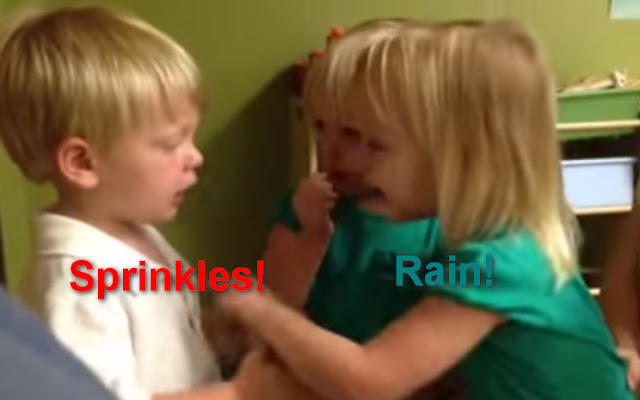
Sprinkles vs rain: Toddlers debate the weighty issue. (YouTube / Tara Willmott)
Certainly politics, religion and even climate change are hotly debated topics but as a video shows, toddlers can get pretty fired up about whether it is sprinkling or raining.
Posted to YouTube yesterday, the video portrays how quickly a discussion about the weather can get heated.
A young boy insists it is just sprinkling – because his mom told him it was – while two twin girls demand it is raining.
Strong words are exchanged and soon some poking ensues. The boy learns a harsh lesson about disagreeing with girls as one ‘pokes his heart’ and brings him to tears.
Like many debates likely conducted by these toddlers’ parents, in the end everyone insists they are right and no minds seem to be changed. 😉
The twin terrors of the June 16, 2014 tornadoes near Pilger and Wisner, Nebraska were captured on video. (YouTube / Timothy Klaustermeier)
Severe weather struck eastern Nebraska on June 16 spawning an amazing four EF-4 rated tornadoes in less than an hour. Two of these were twins, formed from the same supercell thunderstorm at nearly the same time, and stunning video from a resident’s porch shows the beasts.
While this event and the video are a few weeks old, it is well worth sharing. The imagery is a stunning display of Mother Nature’s most violent phenomena.
Timothy Klaustermeier took the video and posted it to YouTube. The nearly seven minute long video shows both tornadoes that spawned near Pilger and lifted north of Wisner. Amazingly the man appears to have been quite calm during the event as the only sounds heard are the roaring of the twisters.
Two other twisters in the same area, one just before and one just after the twins, were also rated EF4s.
Extensive damage was seen in the areas of Pilger and Wisner. Two fatalities were recorded: A five year old girl and a 75 year old man. Sixteen people were critically injured in the storms.
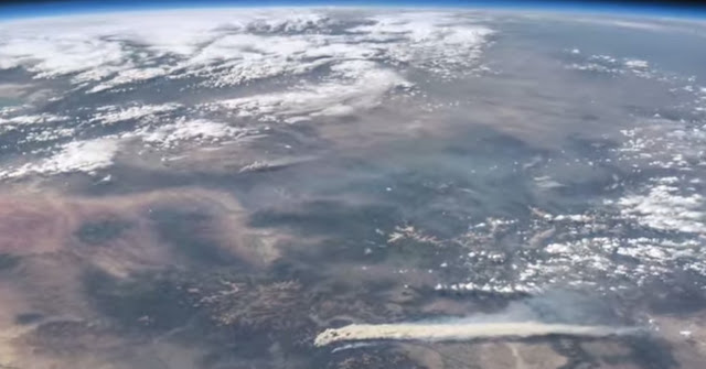
A scene from a new NASA video shows Colorado’s West Fork Fire in June 2013 among other area weather and climate events. (NASA / YouTube)
A stunning video released by NASA this week provides a bird’s eye view of some of the Earth’s most significant weather and climate events of last year.
Using images and movies from satellites and the International Space Station, scenes from across the globe are shown in the video titled “Earth from Orbit 2013.”
Colorado and surrounding states however will draw the most attention from many locally.
From their perch high above, imagery of Colorado’s West Fork Fire in June 2013 is seen as well as the effects of the September floods.
To our south, the drought in New Mexico is seen having taken its toll on Elephant Butte Reservoir in New Mexico. The veritable explosion of storm cells that lea to devastation in Oklahoma during a May tornado outbreak are also shown.
Below the video you will find a description of each scene and links to more imagery.
From NASA – Published on Apr 21, 2014:
A fleet of orbiting satellites monitors Earth constantly. The satellites from NASA and other space agencies give us a fresh, wide perspective on things that we can see from the ground — and things that we can’t.
A look back at Earth in 2013 from the viewpoint of orbit reveals the kind of data gathering and technical achievement that are the reason NASA puts Earth-observing satellites in space. A visualization of satellite and computer model data shows how a cloud of dust from the Chelyabinsk meteor moved around the world. NASA satellites measured the intensity of wildfires, the salinity of the oceans and rainfall around the globe — whether it was too little or too much.
To learn more about NASA’s Earth science in 2014, please visit: www.nasa.gov/earthrightnow
It was sure slow coming with most of the day featuring a light rain / snow mix. At about 4:00pm the snow finally began in earnest. The video below was taken from the ThorntonWeather.com backyard.
Weather, natural disasters & climate news and information.