Tag Archives: January Weather

January 8 to January 14 – This Week in Denver Weather History

January 8 to January 14 - This Week in Denver Weather History

January in Colorado is known for two main weather conditions – cold and wind. Our look back at this week in Denver weather history shows why this reputation is well earned.

From the National Weather Service:

7-8

In 1911…gale force winds occurred in Boulder causing minor injuries.

In 1937…cold arctic air plunged temperatures below zero for an estimated 56 consecutive hours. Two temperature records were set. High temperatures of 8 degrees below zero on the 7th and 3 degrees on the 8th were record low maximum readings for those dates. Low temperatures plunged to 12 degrees below zero on the 7th and 11 degrees below zero on the 8th. Snowfall was 1.4 inches in downtown Denver.

In 1969…a violent evening windstorm struck Boulder and the adjacent foothills. A wind gust to 130 mph was recorded at the National Center for Atmospheric Research. Winds reached 96 mph in downtown Boulder. The Boulder airport wind recorder was blown away after measuring a wind gust to 80 mph. The windstorm caused over one million dollars in damage and one fatality in Boulder. About 25 homes in south Boulder had roofs blown off or were severely damaged. Roofs were blown off buildings housing scientific laboratories and offices of the Environmental Science Services Administration…now NOAA…in Boulder…and installations of several scientific measuring sites near Boulder received heavy damage. Grass fires driven by the high winds endangered many areas…but were controlled by volunteer firemen. One man died from injuries received when he was blown from a fire truck. One man was killed and another injured when the truck camper in which they were riding was blown off I-25 about 10 miles north of Denver. In the same area a mobile home and a truck trailer were blown off the highway and demolished. At least 20 people in the Boulder area received light to serious injuries from flying debris or from being blown into obstructions. Power lines and trees were downed over a wide area. Damage was relatively light in the city of Denver…where northwest winds gusted to 62 mph at Stapleton International Airport on the 8th. Many windows were broken in Arvada…Englewood…and Littleton. A 27-year-old fire lookout tower on Squaw Mountain…west of Denver…was blown away…and several radio relay towers at that location were toppled. Trucks were overturned near Georgetown. Mobile homes were overturned in several areas with occupants receiving injuries in some cases. The strong Chinook winds also brought warm weather. The maximum temperature of 69 degrees on the 7th broke the old record of 65 degrees set in 1948. The temperature also reached 65 degrees on the 8th…but was not a record.

In 1992…an intense blizzard buried eastern parts of metro Denver. At times snow fell at rates of 2 to 3 inches an hour. Winds increased from the north at speeds of 25 to 45 mph. Drifts of 4 to 8 feet were common. I-70 was closed east of Denver…and I-25 was closed from Denver south. Snowfall totals ranged from a couple of inches in the foothills west of Denver to as much as 2 feet on the east side of metro Denver. The heaviest snow fell on the 7th in a band from the northern suburbs of Westminster and Thornton through Aurora and east Denver to southeast of Parker. Snowfall totals included: 22 inches in southeast Aurora…14.8 inches at Stapleton International Airport…13 inches in Northglenn…10 inches in Parker…and 9 inches in Westminster. The 14.5 inches of snowfall measured on the 7th into the 8th is the greatest 24 hour snowfall ever recorded in the city during the month of January. North winds gusting to 46 mph caused much blowing snow at Stapleton International Airport.

In 2000…high winds developed in and near the Front Range foothills. The strongest winds were generally confined to foothills areas north of I-70. A wind gust to 76 mph was reported in Golden Gate Canyon. West winds gusted to 37 mph at Denver International Airport on the 8th.

7-10

In 1962…a major winter storm dumped 13.5 inches of snow on metro Denver. A foot of the snow fell on the 8th when northeast winds gusted to 30 mph. The storm was followed by an intense blast of very cold arctic air. Minimum temperature readings of 24 degrees below zero occurred on both the 9th and 10th. The temperature never reached above zero on the 9th when a maximum reading of 1 degree below zero was recorded. Temperatures were below zero for 37 consecutive hours.

8

In 1912…northwest winds were sustained to 40 mph with gusts to 45 mph in downtown Denver.

In 1971…wind gusts to 52 mph were recorded in downtown Boulder. Northwest winds gusted to 28 mph at Stapleton International Airport.

In 1990…high winds gusting from 50 to 90 mph along the Front Range produced much damage from blowing dust and gravel throughout the day. Wind gusts to 92 mph were recorded in the Table Mesa area of southwest Boulder. The winds caused sporadic power outages. Clouds of dust and gravel whipped by 70 to 90 mph gusts blinded commuters on the Denver-Boulder Turnpike near Broomfield during the morning rush hour. Flying gravel shattered windows on 50 vehicles parked near a Boulder high school. High winds were also blamed for partially dismantling a house under construction in Boulder…as well as toppling a number of fences…billboards…signs…and power poles. The strong cross-winds jack-knifed and overturned semi-tractor trailers on I-70 near Golden and just south of Boulder on State Highway 93. Several county airports were closed due to strong winds and blowing dust reducing visibilities. Wind delays up to 30 minutes occurred at Stapleton International Airport where west winds gusted to 48 mph. Eighty mph winds in Georgetown…Empire…and Idaho Springs were blamed for power and telephone outages. Windows were blown out of a sheriff’s car along I-70 east of Georgetown. The strong Chinook winds warmed the temperature to a high of 60 degrees in Denver.

In 2007…strong winds associated with an intense upper level jet…and a very strong surface pressure gradient…developed in and near the Front Range foothills. Peak wind gusts ranged from 77 mph to 115 mph. The strong winds coupled with freshly fallen snow resulted in whiteout conditions and several highway closures due to blowing and drifting snow. Road closures included: State Highway 93 between Golden and Boulder; State Highway 128 from Wadsworth Boulevard to State Highway 93; U.S. Highway 36…the Denver Boulder Turnpike from Broomfield to South Boulder Road; and State Highway 74 near Evergreen…between County Road 65 and Lewis Ridge Road. More than 100 people were stranded in their cars between Golden and Boulder as blowing and drifting snow made the highway impassable. Snow drifts along State Highway 93 were over 6 feet in depth. As a result… The American Red Cross opened a shelter at Arvada West High School for the stranded commuters. Up to twenty cars were also abandoned along the Diagonal Highway…between Boulder and Longmont. Thirty vehicles were stranded along State Highway 128. The high winds also caused intermittent power outages in Boulder. West winds gusted to 40 mph at Denver International Airport

Continue reading January 8 to January 14 – This Week in Denver Weather History

Thornton sees beautiful sunset, unusual cloud formations

A circular formation on the bottom of a cloud punctuates Thornton's sunset on Thursday, January 5, 2012. (ThorntonWeather.com)

The past week has brought some beautiful sunrises and sunsets to the Colorado Front Range.  The evening of Thursday, January 5, 2012 was no exception as Thornton was treated to an amazing display.

Wave clouds are formed by atmospheric ‘waves’ of wind flowing up and down mountains.  Here in Colorado we have had a pretty consistent wave cloud hovering over the Denver metro area this past week.

On Thursday evening, this cloud was present and lit up in shades of orange and red as the sun set behind the Rocky Mountains.  What made the beautiful scene amazing was an unusual circular formation in the bottom of the cloud.

  • Stay up to date with Thornton’s weather: ‘Like’ us on Facebook, follow us on Twitter and add us to your Google+ circles

Below are images we took of the clouds at about 5:20pm yesterday.

January 1 to January 7 – This Week in Denver Weather History

January 1 to January 7 - This Week in Denver Weather History

One of our coldest and driest months, January is not normally known for its weather extremes. However just like any in Colorado, significant events can occur as we see in our look back at this week in Denver weather history.

From the National Weather Service:

31-1

In 1900…low temperatures dipped to 19 degrees below zero on both days to establish daily record minimum temperatures.

In 1975…only 4.2 inches of snow fell at Stapleton International Airport…while north of Denver a major blizzard raged. All roads north of Denver into Wyoming were closed when strong winds whipped snow into 5 to 6 foot drifts. North winds gusted to 43 mph at Stapleton International Airport on the 31st…causing some blowing snow. Freezing drizzle also fell on the 31st.

In 1984…heavy snow fell in the foothills with 8 inches at Boulder and 6 inches in southern and western metro Denver. Only 1.5 inches of snow fell overnight at Stapleton International Airport.

In 1991…a New Year’s Eve snow storm dumped 2 to 8 inches of snow across northeastern Colorado. Snowfall totaled 3.4 inches at Stapleton International Airport. The 1.9 inches of snow that fell on the 31st was the only measurable snowfall of the month.

In 2008…another brief period of high winds occurred in and near the foothills of Boulder and Jefferson counties. In Nederland…the strong wind snapped a blue spruce which landed on a nearby propane tank. Some roofs in the immediate area were damaged and power lines were downed; which left 126 residences without electricity for six hours. Peak wind gusts included 90 mph at the national wind technology center…and 89 mph; 6 miles northwest of Boulder. At Denver International Airport…a peak wind gust of 23 mph was measured from the southwest.

31-6

In 1973…the 31st marked the start of a protracted cold spell that extended into January of 1974 when temperatures dipped below zero on 7 consecutive days. Record daily minimum readings occurred on the 3rd and 5th when the temperature plunged to 17 degrees below zero on both days. A record low daily maximum temperature of only 4 degrees occurred on the 5th.

31-7

In 1941…a protracted cold spell through January 7…1942… Produced below zero low temperatures on 7 of the 8 days. A low temperature of 2 degrees on the 3rd prevented a string of 8 days below zero. The coldest days during the period were the 1st with a high of 2 degrees and a low of 9 degrees below zero…the 4th with a high of 2 degrees and a low of 11 degrees below zero…and the 5th with a high of 26 degrees and a low of 12 degrees below zero.

1

In 1875…the temperature fell 27 degrees between 3:00 pm and 5:00 pm. The high for the day was 43 degrees…and the low was 8 degrees. Occasional snow flurries fell during the day…but not enough to cover the ground.

In 1885…dense smoke choked the skies over downtown Denver until midday.

In 1910…a rare trace of light rain fell during the morning.

In 1911…post-frontal northeast winds were sustained to 40 mph. Only a trace of snow fell in downtown Denver.

In 1952…snowfall of 0.03 inch was the only measurable snowfall of the month and resulted in 0.01 inch of melted snow…the only precipitation of the month.

In 1956…west-northwest winds gusted to 52 mph at Stapleton Airport.

In 1996…the first snow storm of the new year dumped more than a foot of snow in the Front Range foothills with 4 to 9 inches across the western and southern sections of metro Denver. Snow totals included: 14 inches at conifer; 11 inches at Evergreen; and 10 inches at Eldora Ski Resort… West of Boulder. Snowfall totaled only 1.2 inches at the site of the former Stapleton International Airport. North- northeast winds gusted to 30 mph at Denver International Airport.

In 2003…only a trace of snow fell at the site of the former Stapleton International Airport. This…along with a trace of snow on the 22nd…was the only snow of the month…which equaled the 1934 record for the least snowiest January.

Continue reading January 1 to January 7 – This Week in Denver Weather History

NASA satellite reveals January had fifth largest snow cover in past 45 years

NASA satellite imagery reveals that at one point in January 2011 the nation saw its fifth largest snow cover extent. Click the image for a larger view. (NASA)

How much snow has fallen this season in Colorado all depends on where you are.  The high country has continued to see snowfall far in excess of normal while here on the Plains we remain mostly dry.  For the nation, a new NASA satellite image reveals that 71 percent of it was covered in snow at one point last month.

The new image (right), taken by NASA’s Terra satellite using its Moderate Resolution Imaging Spectroradiometer (MODIS), reveals a snow covered contiguous United States in January.

The image uses false colors to show the snow extent and the length of time it was on the ground.  White areas were completely covered with snow for most of the month whereas the pale green areas had snow for part of the month or were only partly snowy.

On January 12, 71 percent was covered in snow – the fifth largest amount of snow cover in the past 45 years.  In fact, 49 of the 50 states had snow thanks to a significant winter storm that pummeled the Gulf Coast states with Florida being the only hold out.

Despite the expansive snow cover, the National Climatic Data Center said that January 2011 was the ninth-driest January in the United States since 1894.  Further, while snow reached the Gulf Coast states, the southern half of the nation has been very dry with a large area from stretching Arizona to Virginia considered in various stages of drought.

Eastern Colorado is now seeing areas of moderate to severe drought as the lack of snowfall we have seen takes its toll.  In Denver we have recorded only 18.1 inches of snow so far this season – 21.5 inches below what we would normally see through the end of February.  Thornton has barely fared better recording 18.5 inches so far.

From Examiner.com:

Related:

Winter storms take their toll – Snow covers 69% of the lower 48 states

National snow cover map as of January 11, 2011.
Snow now covers nearly three quarters of the lower 48 states and 47 of the 48 have at least some snow. (NOAA)

For much of the lower 48 states of the United States the 2010 to 2011 winter season has been a rough one.  Blizzards and snowstorms have stretched into the Deep South and this morning data shows that nearly three quarters of the nation is covered in snow.

The latest analysis from NOAA’s National Operational Hydrologic Remote Sensing Center shows 69.4% of the lower 48 states covered in snow as of this morning.  This is a significant increase over the 33.1% cover seen in December and bests the previous snow season’s highest number.

Perhaps most interesting is that 47 of the lower 48 states and 49 of all 50 states including Hawaii have at least some snow with the only exception being Florida.  Even the Deep South reaching nearly to the Gulf of Mexico is covered in a blanket of white today after ice and snow pummeled the region yesterday.  Early this morning only five of the 48 did not have some sort of a winter weather warning or advisory in effect.

A snowstorm that started in the South before Christmas moved up the East Coast and left record-setting snow totals in its wake including in New York City.  The same storm that struck the South yesterday now has its sights set on the same area from the mid-Atlantic to New England. 

Continue reading Winter storms take their toll – Snow covers 69% of the lower 48 states

Denver’s January weather preview – A look at our coldest month

Denver's January weather preview.Like any other month in Denver January can yield a wide variety of conditions.  The month is pretty consistently our coldest but by the end of the month we do start to see temperatures slowly start to climb.  Big time snow can and does happen but more often than not the month is quite dry – in fact it is our second driest month of the year.
The real story in January is oftentimes the wind.  Warm but potentially damaging Chinook winds appear with greater frequency and can be a blessing and a curse.  Conversely, cold Bora winds bring dangerous wind chills during the month.

For a complete look at our January weather, a look back at last year and a look ahead at this year’s January weather check out our complete January weather preview.

Winter Weather Advisory issued for the Front Range

Current ThorntonWeather.com webcam image.

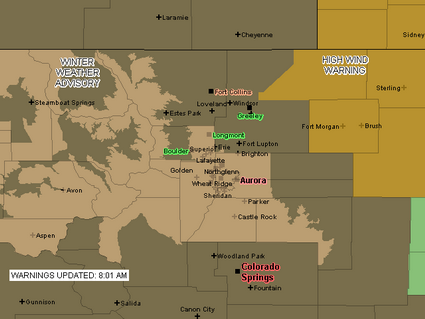
Due to the deteriorating weather conditions, the National Weather Service has issued a Winter Weather Advisory for snow and blowing snow.  Areas under the advisory include the Denver metro area and areas south to Castle Rock as well as some of the mountain areas (see advisory map below).  The storm seems to be lingering over the Front Range longer than expected but the snowfall is still expected to end quickly late this morning.

URGENT – WINTER WEATHER MESSAGE
NATIONAL WEATHER SERVICE DENVER CO
757 AM MST MON JAN 12 2009

..Winter weather advisory in effect until 11 am MST Tuesday…

The National Weather Service in Denver has issued a Winter Weather Advisory for snow and areas of blowing snow…which is in effect until 11 am MST Tuesday.

Snow…heavy at times…will continue within the greater Denver metro area…the southern Front Range foothills and the palmer divide south of Denver. A band of moderate to heavy snow now over the Denver metro area will continue to move south over the palmer divide south of Denver within the next hour. In addition to snowfall…areas of blowing snow will significantly reduce visibilities at times.

Snowfall is expected to taper off rather quickly later this morning…first over the northern Denver metro area and then eventually over the palmer divide and southern foothills by early this afternoon.

Additional snow accumulations by noon today will range from 1 of 3 inches in Boulder and across the northern Denver suburbs to another 3 to
6 inches in the southern Denver and over the palmer divide.

In addition…north winds of 15 to 25 mph will produce areas of blowing snow and very poor visibilities especially over the higher terrain south and southeast of Denver.

A winter weather advisory means that snow…blowing snow…or freezing drizzle will cause travel difficulties. Be prepared for slippery roads and limited visibilities…and use caution while driving.

A Winter Weather Advisory is in effect for much of the Front Range until 11:00am Monday.

Batten down the hatches – here comes the wind again

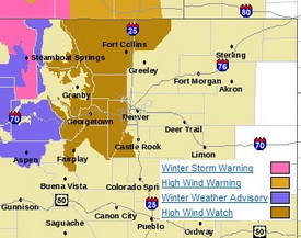
Much of the western and northern Front Range will be under a High Wind Watch starting tonight.

The relative calm of recent days is about to be replaced with high winds not unlike what we saw last week.   Winds will increase tonight and continue through Wednesday east of the Continental Divide.  Areas west of I-25 to the Divide and in the north and central mountain areas will be under a High Wind Watch from late tonight through Wednesday night. 

Much like last week, the usual suspect areas west of I-25 are the places to watch.  Fort Collins, Boulder and the western suburbs of Denver are going to get the worst of the wind.  The Peak to Peak Highway, Highway 287 north of Fort Collins, the Boulder Turnpike west of Broomfield, and Highway 93 between Boulder and Golden are naturally going to be prime targets. 

Wind gusts in excess of 80 mph can be expected in these areas but as we saw last week, other parts of the metro area can receive their fair share of wind as well.  As usual, it is best to put away anything in your yards that could be become a missile and if you are driving in the high wind areas, particular along a north / south route, be prepared for extremely gusty conditions.

Get more local news and weather information on Examiner.com.
This article and many more are posted to the Denver Weather Examiner site.
Visit Examiner.com for more local Denver news and weather.

The good news is that the downslope winds will also bring warmer temperatures – not that you will want to be outside in the wind.  Wednesday we will be well above normal with temperatures in the mid 50’s and Thursday could reach the low 60’s.  There is a slight chance of snow Friday but that isn’t looking to amount to much.

January 2009 weather preview available

A preview of January 2009's weather.

As we continue on what has been a relatively dry season thus far, cold and dry are the key words to remember when it comes to January. The month is the coldest of the year and the second driest as well. Just how cold can January get? The record low temperature for each day of the month is at least 10 degrees below zero.

Just what can we expect in January 2009?  Click here to read our January weather preview.