The only Department of Defense wildfire fighting team is being deployed to aid in the battle against wildfires ravaging Colorado. The hot shot crew from Vandenberg Air Force Base is expected to be on the lines of the Waldo Canyon Fire near the Air Force Academy. Read the rest of this story on Examiner.com and check out the amazing slideshow of the fire approaching the academy.
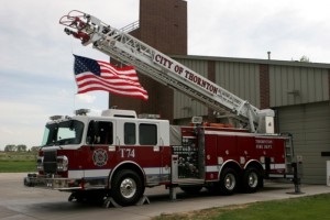
The Thornton Fire Department will be deploying a crew and engine to help support the battle against Colorado's wildfires. (City of Thornton)
With wildfires raging across much of the Colorado high country, nearly half of all available resources in the nation have been deployed to our state. Today the City of Thornton said it would be lending a hand in the battle against these deadly and damaging fires.
The Thornton Fire Department will be joining the multijurisdictional effort and deploying a crew and fire engine to assist with the Flagstaff Fire burning west of Boulder. The blaze started late Tuesday afternoon and forced the evacuation of more than two dozen homes.
While the fire is not the largest or most critical one in the state, by Thornton sending a crew it helps to free up other resources to battle other blazes like the Waldo Canyon Fire near Colorado Springs.
ThorntonWeather.com offers our support for the brave men and women who put their lives on the line to protect us and others across the state. We pray for your safety and success as we deal with this horrible summer of fire.
Update, 2:15pm, from the City of Thornton: “Fire fighters from the Thornton Fire Department mobilized to assist with the Flagstaff Fire in Boulder on June 26. A “Strike Team” from Thornton went to Boulder to provide assistance with structure protection. The Thornton Fire Department remains on standby to assist with any structure protection requested by agencies fighting the fires in Colorado.”
Stay up to date with Thornton’s weather: ‘Like’ us on Facebook, follow us on Twitter and add us to your Google+ circles
Colorado’s deadly and destructive wildfire season continues with as many as a dozen blazes burning in recent days. Smoke from the fires has blanketed parts of the state in recent weeks and new NASA satellite imagery shows the smoke plumes from some of the blazes. Read the rest of this story and view the images on Examiner.com.
Another scorcher in Denver as June 25, 2012 will go into the record books as only the third time the Mile High City registered 105 degrees.
For the fourth day in a row Denver’s temperature broke the 100 degree mark and once again set records in the process. Not only did June 25, 2012 break the record high for the date, it also tied the highest temperature ever recorded in the Mile High City.
Weather record keeping began in Denver in November of 1871. In the nearly 141 years since, only twice has Denver reached 105 degrees – until today.
At 3:34pm the mercury at Denver’s official monitoring station at Denver International Airport reached 105 degrees. This tied the highest temperature ever recorded in the Mile High City which has only been seen twice before. The two previous times were on July 20, 2005 and August 8, 1878.
This of course is a record for June 25 itself as well. The previous record high temperature for June 25 was 100 degrees set in 1991.
The 105 degree reading also is the warmest temperature ever recorded in June. The old record was 104 degrees set on June 26, 1994.
And finally this makes the fourth day in a row that Denver has seen 100+ degree temperatures. Only three other times have that many or more consecutive days recorded readings above the century mark. With forecasts calling for at least one more day of 100+ degree temperatures, the streak may live on.
Thornton sets high temperature marks too
Thornton’s temperatures climbed today as well and broke the 100 degree mark for the third time this month. At 3:53pm ThorntonWeather.com recorded a high of 103° (102.9°). This is the highest temperature recorded by our site since it came online in October 2006.
Denver’s Longest Streaks of 100 Degrees or more
July 4 to July 8, 1989 – Five days (101, 101, 102, 102, 103)
July 19 to July 23, 2005 – Five days (101, 105, 104, 102, 102)
June 29 to July 2, 1990 – Four days (102, 102, 102, 100)
June 22 to June 25, 2012 – Four days – and counting (102, 104, 101, 105)
June 2012 is certain to go down in the history books as one of the warmest on record and June 25 will be one of the big reasons why. At 3:34pm the mercury at Denver's official…
Denver topped out at 102 degrees on June 24 setting a record for the date.
As officially measured at Denver International Airport, the mercury in Denver today topped out at 102 degrees at 3:35pm. This easily breaks the old record for June 24th of 100 degrees set in 2007.
Here in Thornton we fell just shy of the 100 degree mark today as we topped out at 99.3 degrees at 3:55pm. This follows on 102.2 degrees on Saturday and 100.2 degrees on Friday.
This makes it the third day in a row with Denver seeing 100 degrees or warmer temperatures. Only four other times since recordkeeping began in 1878 have there been three or more 100 degree days in a row in the Mile High City.
Denver has recorded 100 degrees or warmer only 73 times including today. Weather forecasts currently call for 100+ degree temperatures for at least the first part of the week giving a chance that the current streak will continue.
Stay up to date with Thornton’s weather: ‘Like’ us on Facebook, follow us on Twitter and add us to your Google+ circles
With wildfires scorching hundreds of thousands of acres across the western United States, the Air Force announced that it would be deploying more of its aircraft in support of the battle against the blazes. Read the rest of this story on Examiner.com
Colorado’s deadly and dangerous fire season continues to worsen as a new fire burning west of Colorado Springs rages out of control. The Waldo Canyon Fire has grown to more than 2,000 acres in less than 24 hours and forced the evacuation of the entire town of Manitou Springs.
June 17 to June 23 - This Week in Denver Weather History
This year the weather in June has been most notable for its heat. That however is far less common than severe weather conditions with lightning, tornadoes and hail. All of these we see in our look back at this week in Denver weather history.
From the National Weather Service:
24
In 1873…there was a great deal of smoke from a fire in the mountains to the southwest of the city during the late afternoon.
In 1875…smoke from forest fires in the mountains to the southwest could plainly be seen from the city.
In 1958…a strong cold front produced a north wind gust to 55 mph at Stapleton Airport where blowing dust briefly reduced the visibility to 1 mile.
In 1982…one inch diameter hail pelted west Denver. A half inch of rain drenched the suburb of Englewood in 10 minutes. Hail piled up to 5 inches deep…snarling rush hour traffic and damaging some stores in a shopping center when the roof started leaking.
In 1988…lightning destroyed the chimney of a house near Evergreen. Another bolt demolished a radio transmitter in the area.
In 1989…golf ball size hail cut a swath 2 1/2 miles wide through open country 14 miles southwest of Bennett. The storm also dropped 1.75 inches of rain on the area. Hail to 3/4 inch in diameter damaged the car of a storm chaser just south of Bennett.
In 1996…a funnel cloud was sighted near Hudson where hail up to 1 3/4 inch diameter fell. Lightning struck a home in Littleton…which sparked a small fire on the roof. Thunderstorm wind gusts to 64 mph were recorded in Castle Rock.
In 2005…severe thunderstorms produced large hail across metro Denver. Hail as large as 1 inch in diameter fell near Castle Rock and Thornton. Hail to 3/4 inch was measured near Northglenn and Fort Lupton.
In 2006…severe thunderstorms raked metro Denver. Hail as large as 2 1/2 inches in diameter shattered automobile windshields in and near Boulder. Hail to 1 3/4 inches pounded areas in and near Lakewood and Morrison. Hail to 1 inch was measured in Wheat Ridge along with 7/8 inch hail in Arvada. Severe thunderstorm wind gusts estimated to 69 mph snapped power lines for a distance of one quarter mile near Castle Rock. Severe thunderstorm winds were measured to 60 mph in Sedalia. Hail as large as 1 inch in diameter fell near Evergreen and Castle Rock. Hail to 3/4 inch in diameter was reported in Louviers and near Conifer.
25
In 1873…forest fires produced a great deal of smoke in the mountains to the southwest of the city.
In 1958…an unusually cold day for summer set two temperature records for the date. Under cloudy skies with occasional drizzle…a record low maximum temperature of 55 degrees was established along with a record minimum temperature of 42 degrees.
In 1959…a waitress…working at a kitchen sink…was injured by a bolt of lightning…which struck the rear of a tavern in Denver. She was hospitalized.
In 1971…a tornado touched down briefly at a high school football field in Brighton…but caused no damage.
In 1981…3/4 inch hail pelted wheat ridge and hail to 1 1/4 inches fell in Louisville. A brief funnel cloud was sighted by national weather service personnel 4 miles east of Stapleton International Airport.
In 1982…a bolt of lightning struck a cabin in the foothills west of Denver. The resulting fire totally destroyed the cabin.
In 1987…golf ball size hail fell near Bennett.
In 1988…a tornado touched down 1 mile south of Watkins and was on the ground for 4 minutes. Another tornado was spotted just southeast of Barr Lake and was on the ground for 5 minutes. No damage was reported from either tornado. Lightning struck two rock climbers near Eldorado Springs. A 25-year-old man was killed…and a 21-year-old man suffered extensive injuries. Thunderstorm winds knocked over two elm trees near downtown Denver. One fell on a house destroying most of it. A nearby building was unroofed…and two cars were damaged. A truck that had been severely damaged by one of the Denver tornadoes 10 days before was hit again. Thunderstorm wind gusts to 51 mph were recorded at Stapleton International Airport.
In 1991…the temperature reached a high of 100 degrees… Setting a new record for the date.
In 1997…one inch diameter hail fell in Arvada and 1 1/2 inch hail in Boulder. Hail as large as 3/4 inches fell in Denver…Louisville…Westminster…and near Broomfield.
In 1999…thunderstorm winds gusted to 58 mph near Fort Lupton toppling an oil rig. A 37-year-old man was killed when he fell 55 feet from the derrick of the rig.
In 2001…four golfers and one construction worker received minor injuries from a nearby lightning strike on the Broadlands Golf Course in Broomfield.
In 2002…hail to 1 inch in diameter was measured in greenwood village.
In 2005…hail to 3/4 inch in diameter fell near Bennett and Roggen. A thunderstorm wind gust to 61 mph was recorded near Golden.
In 2009…lightning struck the Darlington prismatic electric fountain in City Park’s lake. The damage was estimated to be approximately $25000.
In 2010…wind gusts associated with a dry microburst downed several trees in the vicinity of 14th and federal…and near Bayaud St. and Clarkson St. in Denver. At Denver International Airport…a peak wind gust to 45 mph was observed from the southwest.