We found this amusing – a little tidbit from Bloomberg News:
Government officials and activists flying to Bali, Indonesia, for the United Nations meeting on climate change will cause as much pollution as 20,000 cars in a year.
The delegates each will produce an average 4.07 metric tons of carbon dioxide, or CO2, to reach the resort island 950 kilometers (600 miles) from Jakarta, according to estimates e- mailed to Bloomberg by the UN agency holding the conference.
December is normally only our 4th snowiest month so we may not get a lot of relief. Current 30-day forecasts expect near normal temps but slightly below normal precipition. You can read more in our December Climate Preview here.
On our Radar & Maps page, we now have a huge array of weather maps for the western United States as well as national maps. Everything from temperature and humidity to jet stream, satellite, and air quality maps are available! Check it out.
Big changes from recent weather to say the least! Monday we were near 80 degrees but by Wednesday we dropped to a “high” temperature of 28. Tuesday we recorded 2.6″ of snow which brings some desperately needed moisture to the area. Look for the cold to stay with us until Sunday when we will return to the 50’s.
Note: The National Weather Service has been experiencing some problems with their website and that is impacting some of the data shown here on ThorntonWeather.com – particularly the forecasts. To obtain a current forecast manually, please click here.
We’ll reach a high near 50 around mid-day today but clouds will be increasing and the temp will drop quickly after that (see chart below). Tonight expect to see the temperatures drop into the upper teens / low 20’s. The snow has been delayed a bit and most likely won’t arrive till after dark. Accumulations will be light – expect 1 – 3″ in Thornton.
Temperature Forecast – 9:00am Tuesday to 6:00am Wednesday
Wednesday we may not even reach freezing (brrrrr!) with the chance for a bit more snow but it won’t be much, if any. Wednesday night we’ll again be down to the teens and Thanksgiving is looking to be another cold one! Holiday travelers should keep an eye on the developing conditions, particularly if you are driving south on I-25. Be sure to monitor CDOT’s website (http://www.cotrip.org) to get the latest on road conditions.
As always, keep checking back with ThorntonWeather.com for the latest weather conditions and forecasts.
The storm we’ve been keeping an eye on is heading our way and there will definitely be a big change in temperatures. This will bring an end to the very mild weather we have been experiencing and by mid-day Tuesday the front will arrive and the mercury will drop quickly – expect Tuesday’s high temperature to arrive mid-morning and drop from there.
By Tuesday’s afternoon rush hour snow should be falling although unfortunately it doesn’t look like there will be a lot of accumulation. Flurries will continue through Tuesday night into Wednesday with modest accumulations. Heading into Wednesday our high temp will be near freezing and will stay there through most of the holiday weekend. Thanksgiving will definitely be a cold one and anyone heading out on “Black Friday” to get started on Christmas shopping better be bundled up!
Stay tuned to ThorntonWeather.com for more information on this developing system as it becomes available.
This latest report continues the warnings by some in the scientific community that the world is heading for dire consequences from climatic change:
“As early as 2020, 75 million to 250 million people in Africa will suffer water shortages, residents of Asia’s megacities will be at great risk of river and coastal flooding, Europeans can expect extensive species loss, and North Americans will experience longer and hotter heat waves and greater competition for water…”
It is interesting to note that there was a great bit of debate within the panel about the wording of the report, just like there has been within the past. The IPCC issues these reports as if they are fact when in reality the conclusions they reach are done so by consensus. That is significant as just because a majority believe something doesn’t necessarily make it true. There are many experts who doubt man’s impact on the global environment although you would never know it as their voices tend to be drowned out. This debate will continue to rage and critical thinking by everyone should be exercised before making any judgments.
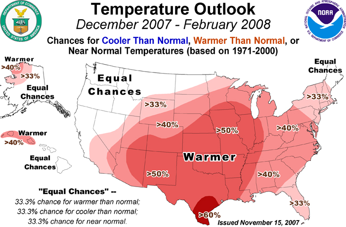
NOAA released its final 90 day winter forecast and little changed from earlier predictions. For Colorado that means the likelihood of warmer than normal temperatures, particularly in the southern part of the state. In terms of precipitation, they foresee equal chances for normal, above and below normal moisture while southern Colorado remains dry.
“Although we are expecting a warmer than normal winter, we do believe there will be fluctuations of warm weather and typical winter weather throughout the season,” said Edward O’Lenic, chief, forecast operations, NOAA Climate Prediction Center. “We encourage people to review winter weather risks for their particular area and information available online to help keep them safe when events do occur.”
The metro area is going through a bit of a dry spell with it having been 25 days (and counting) since our last measurable precipitation. Relief may be on the way toward the middle of next week. The National Weather Service’s outlook says:
“The jet stream will switch from a westerly flow to a northerly flow Tuesday. This flow will persist into next weekend. This will bring much cooler temperatures and a good chance for snow. There is still quite a bit of uncertainty when the periods of snow will occur. Currently the best chance for snow will be Tuesday night and Wednesday.“
Of course forecasting a weather event like this four or five days away is pretty hard. Current indications show the storm arriving around midday Tuesday and hanging around through Wednesday morning. Computer models are saying less than 6″ of snow is expected across northeastern Colorado while the majority of the precipitation heads southeast onto the plains. Stay tuned for more information as it gets closer!
Klaus Wolter predicts that the La Nina pattern that seems to be setting in will drive the jet stream north thus causing Colorado to stay dry. He says, “”I am very concerned that Colorado … might see regions of drought develop by spring.” To read more, click here to read the story in the Rocky Mountain News.
Weather, natural disasters & climate news and information.
 December is normally only our 4th snowiest month so we may not get a lot of relief. Current 30-day forecasts expect near normal temps but slightly below normal precipition. You can read more in our