February 3 to February 9: This Week in Denver Weather History

This Week In Denver Weather History
February 3 to February 9: This Week in Denver Weather History

Denver’s February weather is usually relatively uneventful although that isn’t always the case as we can see from our look back at this week in Denver weather history. From extreme cold to major snowstorms and damaging winds, this period has seen some historically significant events.

From the National Weather Service:

30-7

In 1985…a cold front on the 29th produced a protracted cold spell as arctic air remained entrenched across metro Denver. While the only daily temperature record set was a low maximum reading of 2 degrees on February 3rd…minimum temperatures plunged well below zero on 9 consecutive days. The coldest readings were 15 degrees below zero on January 31st and 14 degrees below zero on February 5th.
31-8

In 1963…warm weather that began with the strong Chinook winds on the 31st and 1st continued through the 8th. Maximum temperatures through the period ranged from 52 degrees on the 2nd to 76 degrees on the 5th…which was a new record high for that date.

31-12

In 1899…a protracted cold spell lasted almost two weeks. Low temperatures plunged below zero on all days but February 9th with a reading of 6 degrees. The coldest low temperature of 22 degrees below zero on February 6th was a record low for the date. Low temperatures of 20 degrees below zero occurred on both February 11th and 12th… But only the 11th remains as the record minimum for the date. High temperature of only 5 degrees below zero on February 11th was a record low maximum for the date. High temperatures climbed to only zero degrees on both February 2nd and 3rd…but were not records. Intermittent light snow or flurries fell during the period. The most snowfall…2.0 inches…occurred on February 2nd.

1-3

In 1996…cold arctic air plunged temperatures below zero for more than 35 consecutive hours from late on the 1st until sunrise on the 3rd. The temperature warmed to only 1 degree below zero on the 2nd after a record low of 16 degrees below zero.

1-4

In 2011…a frigid arctic airmass settled into Front Range urban corridor. At Denver International Airport… Overnight low temperatures…from the 1st to the 3rd… Were 13 below zero…17 below zero and zero respectively. The icy temperatures caused pipes to crack and burst following the freeze. In Loveland…firefighters responded to more than a dozen water pipe breaks…most in fire sprinkler systems at businesses…apartments and assisted care facilities. At cu earth science library in Boulder…more than 1000 books and several costumes for an upcoming production were damaged. At the County courts administration building in Jefferson County…a steady stream of water from a crack on the 5th floor… Went unnoticed on the 3rd and flooded all the floors of the administration wing overnight. As a result…much of the office equipment…furniture and carpet sustained water damage. A burst sprinkler line caused minor damage at the Platte Valley Medical Center in Brighton. The icy temperatures forced to closure of several school districts as well.

1-5

In 1985…the most bitter cold spell of the winter season brought sub-zero temperatures to metro Denver. Daily low temperature records were broken at Denver. The usual cold weather problems struck including stalled vehicles…jammed traffic lights…and frozen water and sewer lines. At Stapleton International Airport…the high temperature was only 2 degrees above zero on the 1st…setting a record low maximum for the date. Low temperatures reached 13 below zero on the 1st…12 below on the third…and 14 below on the 5th.

1-6

In 1989…one of the century’s worst doses of winter weather ravaged the entire state. Bitterly frigid weather moved into metro Denver on the 1st as snow buried many sections of the state. In metro Denver where 3 to 6 inches of snow fell…blowing snow and resultant poor visibilities caused a 46-car pile-up on I-25 in the middle of the city on the 4th. During the period…2 to 3 hour delays were common at Stapleton International Airport where snowfall from the storm totaled 4.3 inches and northeast winds gusted to 30 mph on the 1st. Intense cold accompanied the storm. Temperatures in Denver stayed below zero continuously for the best part of 3 days (3rd…4th…5th)…for a total of 69 hours. This is the fourth longest sub-zero period on record. Wind chill temperatures reached 50 degrees below zero. The mercury dipped to 24 degrees below zero on the 5th…setting a record for the date. This was the city’s coldest temperature in over 26 years. Low temperatures dipped below zero on 8 consecutive days (2nd-9th). High temperature of 9 degrees below zero on the 4th was a record low maximum for the date…as was the high of 5 degrees on the 5th. Extensive damage occurred when pipes and water lines froze and broke. Thousands of cars failed to start. On the 3rd…a 57-year-old woman died of hypothermia in an Arvada park. Eighteen high school students were treated for hypothermia after a 2-hour ride through Jefferson County in an unheated bus. At least 2 cases of frostbite were reported; there were undoubtedly many more.

Continue reading February 3 to February 9: This Week in Denver Weather History

January 2013 Thornton weather recap: A colder and drier than average month

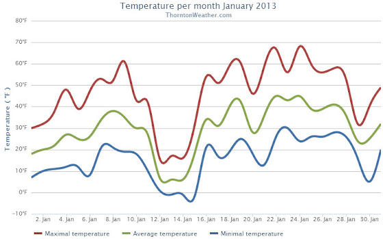
Looking back at January 2013 the numbers reveal a month that wasn’t particularly extraordinary by any measure.  Temperatures were slightly below average and precipitation was a bit less than normal.

The first half of the month was notable for cold while the second half for the most part was considerably warmer.

Temperatures for the first three days were well below normal before we entered a brief period with above average temperatures.  That was followed by very cold days on the 12th and 13th when high temperatures only reached the teens.  Most of the following two weeks were notable for highs in the 50s and 60s.

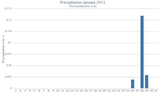
The month started out extraordinarily dry with a mere 0.3 inch of snow being recorded during the first 27 days.  On the 28th though we received a decent little shot of snow to drive up the numbers.

The average temperature for the month came in at 29.7 degrees.  This was a full degree below the Denver January average of 30.7 degrees.  At the official Denver station at Denver International Airport, the monthly average was slightly warmer at 30.3 degrees.

Temperatures in Thornton ranged from a high of 67.8 degrees on the 24th down to a low of -2.4 degrees on the 15th.  Denver recorded a highest temperature of 66 degrees, also on the 24th, and a low of -12 degrees on the 12th.

There were no temperature records set during the month.

In terms of precipitation, an anemic 0.21 inch was measured in Thornton while Denver fared better with 0.31 inch.  The January average is 0.41 inch so both locations were a good bit below normal.

Snowfall was similarly light with Thornton recording 3.7 inches, most of which fell during the storm on the 28th and 29th.  Out at DIA Denver officially measured 4.6 inches for the month.  Average for January is 7.0 inches.

None of the precipitation or snowfall measurements were records.

Click here to view Thornton’s January 2013 Climate Summary

2013-02-01_161619.jpg
Thornton, Colorado January 2013 Temperature Summary. (ThorntonWeather.com)
2013-02-01_161652.jpg
Thornton, Colorado January 2013 Precipitation Summary. (ThorntonWeather.com)

From the National Weather Service:

...THE DENVER CLIMATE SUMMARY FOR THE MONTH OF JANUARY 2013...

CLIMATE NORMAL PERIOD 1981 TO 2010
CLIMATE RECORD PERIOD 1872 TO 2013

WEATHER         OBSERVED          NORMAL DEPART LAST YEAR`S
                 VALUE   DATE(S) VALUE   FROM    VALUE DATE(S)
                                          NORMAL
................................................................
TEMPERATURE (F)
RECORD
 HIGH              76   01/27/1888
 LOW              -29   01/09/1875
HIGHEST            66   01/24        76     -10       66 01/21
LOWEST            -12   01/12       -29      17       -6 01/11
AVG. MAXIMUM     44.6              44.0     0.6     50.3
AVG. MINIMUM     16.0              17.4    -1.4     21.6
MEAN             30.3              30.7    -0.4     36.0
DAYS MAX >= 90      0               0.0     0.0        0
DAYS MAX = .01         4               4.1    -0.1        4
DAYS >= .10         1               0.9     0.1        1
DAYS >= .50         0               0.0     0.0        0
DAYS >= 1.00        0               0.0     0.0        0
GREATEST
 24 HR. TOTAL    0.22   01/28 TO 01/29

SNOWFALL (INCHES)
RECORDS
 TOTAL           24.3   1992
TOTALS            4.6               7.0

DEGREE_DAYS
HEATING TOTAL    1067              1063       4      891
 SINCE 7/1       3300              3531    -231     3325
COOLING TOTAL       0                 0       0        0
 SINCE 1/1          0                 0       0        0

FREEZE DATES
RECORD
 EARLIEST     09/08/1962
 LATEST       06/08/2007
EARLIEST                        10/07
LATEST                          05/05
..................................................

WIND (MPH)
AVERAGE WIND SPEED              8.8
RESULTANT WIND SPEED/DIRECTION   4/205
HIGHEST WIND SPEED/DIRECTION    38/290    DATE 01/24
HIGHEST GUST SPEED/DIRECTION    45/290    DATE 01/24

SKY COVER
POSSIBLE SUNSHINE (PERCENT)   MM
AVERAGE SKY COVER           0.50
NUMBER OF DAYS FAIR            8
NUMBER OF DAYS PC             20
NUMBER OF DAYS CLOUDY          3

AVERAGE RH (PERCENT)     48

WEATHER CONDITIONS. NUMBER OF DAYS WITH
THUNDERSTORM              0     MIXED PRECIP               0
HEAVY RAIN                0     RAIN                       0
LIGHT RAIN                1     FREEZING RAIN              0
LT FREEZING RAIN          0     HAIL                       0
HEAVY SNOW                1     SNOW                       1
LIGHT SNOW                5     SLEET                      0
FOG                       7     FOG W/VIS

Thornton’s February weather preview: Milder temps, dry conditions typical during month

Denver Climatological Preview - February 2013As we wrap up a January that was pretty much average in terms of temperature and precipitation, we look to February with hope for relief from the dry conditions we have seen thus far this winter.  Unfortunately historically February is a relatively dry month but we do start working off winter as temperatures climb.

To date Denver’s seasonal snowfall is 10.8 inches below average and Thornton is even further behind.  February though is only the Mile High City’s sixth snowiest month so while we can receive big storms in February, we can’t count on making up much ground.

For those looking forward to milder weather, average temperatures do increase during the month as a sign that winter is fading and spring is approaching.

For the complete February preview including a look at historical averages and extremes as well as a look at what long range forecasts are predicting, click here. 

Photo gallery: Rocky Mountain Arsenal National Wildlife Refuge

A bald eagle rests on a dead tree stump near the entrance to the Rocky Mountain Arsenal National Wildlife Refuge.  See more photos in the slideshow below.
A bald eagle rests on a dead tree stump near the entrance to the Rocky Mountain Arsenal National Wildlife Refuge. See more photos in the slideshow below.

Public access to the Rocky Mountain Arsenal National Wildlife Refuge has increased greatly now that they allow visitors to drive their own vehicles through the facility.  We have taken advantage of it over the past couple of weeks and have enjoyed some extraordinary photo opportunities.

A wide variety of birds are available for viewing but the hawks and eagles draw the most attention.  These are readily seen throughout the refuge although the trees right near the entrance seem to be a very popular spot with them.  We were able to get extraordinarily close to one bald eagle that didn’t seem to mind visitors at all.

Deer and of course prairie dogs abound at the arsenal and are easily spotted.  Also routinely seen are coyotes but seeing them requires a keen eye as they blend in with the grass.

Up until this past week the refuge’s bison herd largely had remained out of sight.  Most were in areas not accessible to the public and the few that were mostly stayed hidden.  This week though the herd moved into the main area and on our recent visit we found them right on the road.

Below are some of the photos we have taken in recent weeks.

On the net:

January 27 to February 2: This Week in Denver Weather History
This Week In Denver Weather History
January 27 to February 2: This Week in Denver Weather History

High wind and heavy snow events dominate our look back at this week in Denver weather history. Most notable is a major snowstorm just last year that helped to provide at least some relief from tinder dry conditions. Hopefully we can see some of that this year!

From the National Weather Service:

25-27

In 1897…a cold spell resulted in three temperature records. Low temperature of 14 degrees below zero on the 27th was a record minimum for the date. High temperatures of only 3 degrees on the 25th and 2 degrees on the 26th were record low maximums for the dates. Very light snow or flurries fell on the 25th and 26th at times.

26-27

In 1944…heavy snowfall totaled 8.0 inches in downtown Denver. Most of the snow…7.0 inches…occurred on the 26th when northwest winds were sustained to 17 mph.

In 1973…at Stapleton International Airport…only 3.8 inches of snowfall were measured and north winds gusted to 40 mph causing some blowing snow…while over the Colorado eastern plains heavy snow accompanied by high winds created widespread blizzard conditions closing many highways.

In 1994…the combination of an upper level storm system and moist upslope winds brought heavy snow and cold temperatures to metro Denver and much of eastern Colorado. Snowfall across metro Denver averaged 5 to 7 inches. Snowfall totaled 3.8 inches at Stapleton International Airport where east winds gusted to 21 mph on the 26th.

In 2000…snow…heavy in the mountains…spread over the foothills and metro Denver. Eight inches of snow were measured at Bergen Park and near Evergreen. Snowfall totaled 3.8 inches at the site of the former Stapleton International Airport.

26-1

In 1888…a protracted warm spell lasted a week. Maximum temperatures ranged from 62 degrees on the 29th to an all-time record high for the month of 76 degrees on the 27th. Daily record high temperatures of 76…69…and 71 occurred on the 27th…28th…and 30th respectively. Record high minimum temperatures of 47 and 34 occurred on the 26th and 27th.

27

In 1888…the highest recorded temperature in January…76 degrees…occurred.

In 1967…strong winds caused a power outage in Boulder.

In 1984…this was the last day of 63 consecutive days with snow cover of one inch or more in Denver. This longest period of snow cover on record began with the Thanksgiving weekend blizzard on November 26-27…1983… When 21.5 inches of snow fell at Stapleton International Airport. Additional snowfall during December and January prolonged the event. Snow depth on the ground to the nearest inch was measured once daily at 5:00 am MST.

27-28

In 1899…snowfall totaled 6.2 inches in the city. Northeast winds were sustained to 36 mph with gusts to 40 mph on the 28th.

In 1965…high winds raked the Front Range foothills. West winds gusted to 89 mph on Table Mountain in Boulder…87 mph at Rocky Flats…and 54 mph at Stapleton International Airport. Damage and minor injuries occurred in Boulder and western metro Denver. Four men were injured by wind- caused accidents while working on construction…2 in Denver and 2 in Boulder. There was extensive damage to power lines… Buildings…signs…and trees. Some minor accidents were caused by blowing dust and debris. Blown dust accumulated 2 to 3 feet deep on some lawns in northern metro Denver suburbs. Dust blew into buildings and homes.

In 1989…the heaviest snowstorm of the winter dumped 9 to 15 inches of snow across metro Denver. Snowfall totaled 8.8 inches at Stapleton International Airport with most of the snow…8.6 inches…falling on the 28th. Strong north winds gusting to 46 mph whipped the snow into 2-foot drifts and reduced visibility in blowing snow. The foothills received up to 18 inches of snow. The snow fell on a weekend…so closures and other disruptions were minimal. The public reported thunder in Arvada…Wheat Ridge…and Boulder on the evening of the 27th. A thunderstorm produced snow pellets at Stapleton International Airport during the early morning hours of the 28th. This was the first thunderstorm in the city during January since 1932.

In 1996…winds to hurricane force were reported across the Front Range foothills in the wake of a pacific storm system. Recorded wind speeds included: 86 mph at the National Center for Atmospheric Research southwest of Boulder…86 mph atop Squaw Mountain west of Denver…and 75 mph at Jefferson County Airport in Broomfield. West-northwest winds gusted to 48 mph at Denver International Airport on the 28th.

In 2009…high winds buffeted the foothills of Boulder and Jefferson counties. Peak wind gusts included: 101 mph at Eldora Ski Resort…100 mph…6 miles northwest of Boulder; 84 mph at NCAR Mesa Lab…79 mph…5 miles northwest of Boulder; and 75 mph at the national wind technology center. In Nederland…a wind turbine recently installed was damaged by the high winds. A peak wind gust of 38 mph occurred at Denver International Airport on the 28th.

27-31

In 1951…a major storm dumped 10.1 inches of snowfall at Stapleton Airport. Most of the snow…8.3 inches…fell on the 29th. Cold arctic air accompanied the snow. Several temperature records were set…including record low maximum temperatures of 4 on the 28th and 4 below zero on the 29th and record low temperatures of 12 below zero on the 29th and 24 below zero on the 31st. Temperatures were below zero for 45 consecutive hours.

Continue reading January 27 to February 2: This Week in Denver Weather History

North-central Colorado snowpack at second lowest level to date in 34 years

The 2012 / 2013 snow season has been dismal and while December brought some hope for recovery, recent weeks have seen snowpack decline once again.  For the drought and fire weary state of Colorado the data does not bode well.

For the north-central Colorado mountains, the January 22 snowpack is at its second lowest level to date since 1979.  Only 1981 saw worse results this far into the season.

According to the latest Colorado SNOTEL reports, the South Platte, North Platte and Upper Colorado River basins are at 57%, 65% and 60% of normal respectively.  Statewide Colorado snowpack is a dismal 62% of average.

Is there hope?  Mother Nature certainly works on her own schedule so it is possible we could see a recovery.  However the latest 3-month outlook from the Climate Prediction Center forecasts warmer and drier than normal temperatures.

North-central Colorado snowpack through January 22. (NRCS)
North-central Colorado snowpack through January 22. Click the image for a larger view. (NRCS)

Obama warns of ‘threat of climate change’ in second inaugural address

After taking the oath of office for his second term, President Barack Obama laid out his vision for the next four years and included a call to action to battle the ‘threat of climate change.’

Mid-way through his address the president said, “We, the people, still believe that our obligations as Americans are not just to ourselves, but to all posterity. We will respond to the threat of climate change, knowing that the failure to do so would betray our children and future generations.”  Read the rest of this story and watch video of Obama’s climate change commentary on Examiner.com.

President Barack Obama is sworn in for his second term by Chief Justice John Roberts. Michelle Obama holds the bibles while daughters Malia And Sasha look on. (Getty Images)

Weather and Inauguration Day: Mother Nature can play a role in the swearing in

President Barack Obama will be sworn in for his second term today and while the weather looks to cooperate for the ceremony on the steps of the Capitol, that hasn’t always been the case. Mother Nature has impacted previous Inauguration Days and most famously led to the death of a president.  Read the rest of this story on Examiner.com

Artist's depiction of March 4, 1841 and William Henry Harrison's inauguration. Harrison contracted pneumonia on a wet and cold day would die 30 days later. Learn more at the link. (Library of Congress)

January 20 to January 26: This Week in Denver Weather History

This Week In Denver Weather History
January 20 to January 26: This Week in Denver Weather History

Damaging wind events dominate our look back at this week in Denver weather history. Also making appearances are extreme cold and significant snowstorms.

14-21

In 1930…a protracted cold spell occurred when low temperatures plunged below zero on 8 consecutive days. The coldest low temperatures of 20 degrees below zero on the 17th and 19 degrees below zero on the 16th were record minimums for the dates. High temperatures during the period ranged from 18 on the 18th to zero on the 20th. Two degrees on the 15th was a record low maximum temperature for the date.

15-23

In 1962…a protracted cold spell kept metro Denver in the deep freeze for more than a week. From the 15th thru the 23rd…low temperatures were zero or below for 9 consecutive days…but a daily record low was set only on the 22nd when the temperature dipped to 14 degrees below zero. A record low maximum for the date was also set on the 22nd when the temperature climbed to only 11 degrees. The coldest high temperature was 3 degrees above zero on the 21st…which did not break the record. The protracted cold was broken for only a few hours on the afternoon of the 20th when Chinook winds warmed the temperature to a high of 38 degrees before another surge of cold arctic air plunged temperatures back into the deep freeze that evening. The severe cold caused much damage to water systems. A woman was frozen to death at Morrison. There were other deaths attributable to the weather…including traffic deaths and heart attacks from overexertion.

18-20

In 1958…snowfall totaled 6.9 inches at Stapleton Airport where east-northeast winds gusted to 26 mph on the 18th.

18-24

In 2005…a week of mid-winter unseasonably warm weather pushed high temperatures into the 60’s or more on all but one day. During the period…the highest temperature of 70 degrees on the 20th was a new record maximum for the date. Low temperatures remained above freezing on 4 of the days.

19-20

In 1935…snowfall of only 0.8 inch during the evening of the 19th was the only measurable snowfall of the month. The light snow developed behind an arctic cold front as temperatures plunged to a low of 13 degrees below zero on the 20th. High temperature of only 2 degrees on the 20th was a record low maximum for the date. Northeast winds were sustained to 16 mph on the 19th.

In 1986…Chinook winds gusting to 39 mph at Stapleton International Airport provided record breaking warmth. The warmest temperature of the month…68 degrees on the 19th…was also a record high for the date. The low temperature of 41 degrees on the 20th equaled the record high minimum for the date.

In 1991…a strong cold front moved south across metro Denver. Upslope conditions produced 3 to 6 inches of snow along the Front Range with 5 inches in Westminster and 4 inches in Thornton. Snowfall measured 4.9 inches at Stapleton International Airport where north winds gusted to 31 mph.

20

In 1894…northwest winds were sustained to 40 mph with gusts to 45 mph in the city.

In 1911…west Chinook winds sustained to 46 mph warmed the temperature to a high of 62 degrees.

In 1975…a warm Chinook wind produced a west wind gust to 53 mph at Stapleton International Airport. Winds were much stronger near the foothills…where 80 mph winds in Boulder caused damage to homes…buildings…power lines… And autos.

In 1986…high winds buffeted the foothills from Denver north. The strongest reported wind was 72 mph in Fort Collins. A wind gust to 39 mph was reported at Stapleton International Airport in Denver.

In 1996…high winds developed for a short time in the Front Range foothills in the wake of a weak upper level disturbance. Wondervu recorded a peak wind gust to 90 mph… While winds gusted to 84 mph atop squaw mountain near Idaho Springs. West winds gusted to only 29 mph at Denver International Airport.

In 2011…a snowboarder and his dog were killed when he triggered an avalanche in the backcountry northeast of Berthoud Pass.

20-21

In 1973…a major storm produced 7.5 inches of snowfall at Stapleton International Airport where north winds gusted to 32 mph causing some blowing snow.

In 2002…high winds developed over portions of the northern mountains and Front Range foothills. Several trees were blown down in Gilpin County along State Highways 119 and 46. Wind gust reports included: 90 mph 11 miles north of Central City…83 mph near Fritz Peak…76 mph at Aspen Springs…and 80 mph at Nederland. West winds gusted to only 39 mph at Denver International Airport on the 20th.

Continue reading January 20 to January 26: This Week in Denver Weather History

Drought, floods, Sandy, Bopha among disasters on top 10 climate events for 2012

Disasters claimed thousands of lives in 2012 in the form of floods, earthquakes, tropical storms and tornadoes. This week NOAA released its list of top 10 global weather and climate events and natural disasters took their place in a number of spots.  Drought in North America which we of course have seen here in Colorado makes the list as do many other notable disasters.

Read the rest of this story on Examiner.com.

Weather, natural disasters & climate news and information.