Flames from the explosion of the meteor were captured by Russians. (YouTube)
The Friday morning calm in Chelyabinsk, Russia was shattered by a meteor slamming into Earth’s atmosphere and exploding over the city in the Ural Mountains. The energy released was greater than that of the first atomic bombs and caused widespread destruction and injuries.
Photo slideshow and video below
NASA says the 50 foot, 7,000 ton meteor entered the atmosphere at a speed of 40,000 mph and impacted at 9:20 a.m. local time (8:20 p.m. MST).
The energy released by the explosion has been estimated at 300 kilotons – far more than the 16 kiloton explosion of the bomb dropped on Hiroshima and 21 kilotons of the one dropped on Nagasaki.
The meteor lasted in the atmosphere for over 30 seconds before exploding approximately 15 miles above the planet.
Most of the fragments burnt up before reaching the ground however photos from the area did show a large, 20 foot wide hole in the ice on a nearby lake suspected to have been caused by a chunk of the rock.
The loud sonic boom and the resultant shockwave blew out windows in buildings across the area and is believed to have caused the collapse of a wall of an industrial building.
Russia media reports nearly 1,000 people reported injuries including 82 children, two of which are in intensive care. No fatalities have been reported and no one is believed to have been hit by any fragments.
NASA said the meteor was not related to asteroid 2012 DA14 which passed extremely close to the earth today. That asteroid is 150 feet across and came within 17,200 miles of the Earth.
February 10 to February 16: This Week in Denver Weather History
As we continue an incredibly dry winter, we look to history to provide some sort of hope. While there have been some significant snow events this week in Denver weather history, more common is bitter cold and damaging winds.
From the National Weather Service:
15-23
In 1962…a protracted cold spell kept metro Denver in the deep freeze for more than a week. From the 15th thru the 23rd…low temperatures were zero or below for 9 consecutive days…but a daily record low was set only on the 22nd when the temperature dipped to 14 degrees below zero. A record low maximum for the date was also set on the 22nd when the temperature climbed to only 11 degrees. The coldest high temperature was 3 degrees above zero on the 21st…which did not break the record. The protracted cold was broken for only a few hours on the afternoon of the 20th when Chinook winds warmed the temperature to a high of 38 degrees before another surge of cold arctic air plunged temperatures back into the deep freeze that evening. The severe cold caused much damage to water systems. A woman was frozen to death at Morrison. There were other deaths attributable to the weather…including traffic deaths and heart attacks from overexertion.
16
In 1911…a trace of rain fell…a rare event in January.
In 1935…rainfall was 0.01 inch during the afternoon…a rare event in January.
In 1989…wind gusts to 80 mph were reported in southwest Boulder. Winds reached 100 mph at Rollinsville in the foothills southwest of Boulder.
In Golden…the wind blew a 25-foot trailer through a fence and flipped it over. West winds gusted to 37 mph at Stapleton International Airport where the Chinook winds warmed the temperature to a high of 49 degrees.
16-17
In 1886…a brief cold spell resulted in two temperature records. High temperatures of zero degrees on the 16th and 2 degrees below zero on the 17th were both record low maximums for the dates. Low temperatures of 8 degrees below zero on the 16th and 16 degrees below zero on the 17th were not records.
In 1930…temperatures plunging well below zero resulted in two records. Low temperatures of 19 degrees below zero on the 16th and 20 degrees below zero on the 17th were record low temperatures for the dates. High temperatures were 4 degrees on the 16th and 15 degrees on the 17th. Light snowfall totaled 4.0 inches. North winds were sustained to 18 mph on the 16th.
In 1964…high winds struck the eastern foothills. Gale velocity winds were recorded in Boulder with gusts to 83 mph measured at Rocky Flats. Several airplanes were damaged at the Jefferson County Airport in Broomfield. Roofs…walls…and parts of buildings were blown away at various locations. Power poles and trees were blown over.
16-18
In 1943…light snowfall totaled 3.2 inches over the 3 days. This was the only measurable snow of the month. North winds were sustained to 20 mph on the 16th.
In 2011…very strong winds associated with an upper level jetstream over Colorado produced blizzard conditions in the mountains above timberline. Peak wind gusts included: 99 mph atop Loveland pass…94 mph…2 miles southwest of Mary Jane…80 mph atop Berthoud Pass and 79 mph atop Niwot Ridge. Storm totals in the ski areas west of Denver ranged from 8 to 14 inches.
5-11
In 1978…the 5th marked the start of a record 7 consecutive days of dense fog at Stapleton International Airport. The heavy fog reduced the visibility to 1/4 mile or less for a period of time on each of these days. Light snow and/or freezing drizzle occurred on most days. Fog reducing visibility to less than 7 miles was recorded at Stapleton International Airport on 11 consecutive days through the 15th. During the period 5-14…the cold thick fog deposited heavy rime ice up to 5 inches thick on power lines and poles over a wide area of eastern Colorado…causing a major electrical power outage disaster.
NASA depiction of asteroid 2012 DA14 as it passes by the Earth. (NASA)
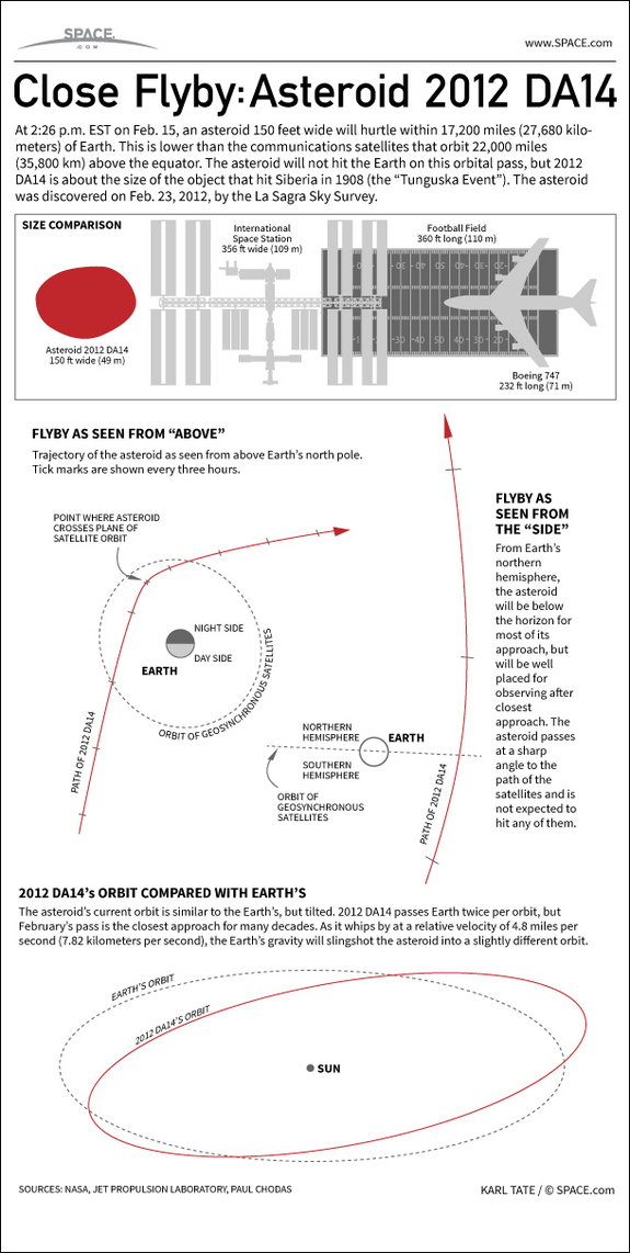
Known formally as ‘Asteroid 2012 DA14’, a massive piece of rock will pass perilously close to Earth on Friday. The 150 foot wide asteroid is similar in size to one that devastated Siberia in the early 20th century.
At its closest to the Earth, asteroid 2012 DA14 will be within 17,200 miles of Earth. That is much closer than the orbit of the moon (239,000 miles) and in fact will pass between Earth and many of our crucial communication satellites.
More than 100 geostationary satellites are perched in orbit at 22,000 miles. While there is no danger of 2012 DA14 hitting the Earth, there is a very remote chance it could collide with one of these manmade satellites.
NASA says that the rock is will be speeding by at 17,400 miles per hour. 2012 DA14 will be at its closest point to earth on Friday, February 15 at approximately 12:24 p.m. MST.
The daytime pass for those in North America will preclude viewing here. However those in Indonesia, Eastern Europe, Australia and Asia should be able to view it with a small telescope.
At 150 feet across, 2012 DA14 is similar in size to an asteroid that exploded over Siberia in 1908 – the “Tunguska Event.” That object created a blast estimated at 1,000 times more powerful that the atomic bomb dropped on Hiroshima and flatted trees across an 800 square mile area.
Asteroids this size can cause extensive regional damage but are nowhere near the scale of the 5-mile-wide one that is thought responsible for wiping out the dinosaurs.
Watch: NASA video explaining asteroid 2012 DA14 below the inforgraphic
Asteroid 2012 DA14 will pass extraordinarily close to Earth on Friday, within 17,200 miles of the planet. In discussing the massive rock hurtling by Earth, one CNN anchor yesterday inexplicably tried to link the celestial event with terrestrial global warming. Watch video and read the comments by Deb Feyerick on Examiner.com.
CNN anchor Deb Feyerick suggested that the close pass of asteroid 2012 DA14 is related to global warming. (NASA)
Asteroid 2012 DA14 will pass extraordinarily close to Earth on Friday, within 17,200 miles of the planet. In discussing the massive rock hurtling by Earth, one CNN anchor yesterday inexplicably tried to link the celestial event with terrestrial…
Two powerful winter storms are set to collide over the northeastern United States today in what could be a record-breaking weather event. Many locations including Boston and New York City will see blizzard conditions in what some are calling a potentially historic event.
Parts of New England will be measuring snow in feet when this storm is finished and it is possible many locations will see their biggest snows on record. NASA satellites captured an amazing image this morning of the region as the storms begin to arrive – see below.
NASA says, “The satellite image, captured at 9:01 a.m. EST, shows clouds associated with the western frontal system stretching from Canada through the Ohio and Tennessee valleys, into the Gulf of Mexico. The comma-shaped low pressure system located over the Atlantic, east of Virginia, is forecast to merge with the front and create a powerful nor’easter. The National Weather Service expects the merged storm to move northeast and drop between two to three feet of snow in parts of New England.”
A massive winter storm is coming together as two low pressure systems are merging over the U.S. East Coast. A satellite image from NOAA's GOES-13 satellite on Feb. 8 shows a western frontal system approaching the coastal low pressure area. (NASA) Click the image for a larger view.
Today, February 5th, we celebrate one of our nation’s most important holidays – National Weatherperson’s Day. In what is truly a very revered occasion, we take time out to honor those men and women who bring joy to schoolchildren when they announce a snow day, are the bearers of bad news when severe weather is about to strike and are prognosticators second only to Jimmy the Greek in their ability to read a crystal ball. Read more about this auspicious occasion on Examiner.com.
February 3 to February 9: This Week in Denver Weather History
Denver’s February weather is usually relatively uneventful although that isn’t always the case as we can see from our look back at this week in Denver weather history. From extreme cold to major snowstorms and damaging winds, this period has seen some historically significant events.
From the National Weather Service:
30-7
In 1985…a cold front on the 29th produced a protracted cold spell as arctic air remained entrenched across metro Denver. While the only daily temperature record set was a low maximum reading of 2 degrees on February 3rd…minimum temperatures plunged well below zero on 9 consecutive days. The coldest readings were 15 degrees below zero on January 31st and 14 degrees below zero on February 5th.
31-8
In 1963…warm weather that began with the strong Chinook winds on the 31st and 1st continued through the 8th. Maximum temperatures through the period ranged from 52 degrees on the 2nd to 76 degrees on the 5th…which was a new record high for that date.
31-12
In 1899…a protracted cold spell lasted almost two weeks. Low temperatures plunged below zero on all days but February 9th with a reading of 6 degrees. The coldest low temperature of 22 degrees below zero on February 6th was a record low for the date. Low temperatures of 20 degrees below zero occurred on both February 11th and 12th… But only the 11th remains as the record minimum for the date. High temperature of only 5 degrees below zero on February 11th was a record low maximum for the date. High temperatures climbed to only zero degrees on both February 2nd and 3rd…but were not records. Intermittent light snow or flurries fell during the period. The most snowfall…2.0 inches…occurred on February 2nd.
1-3
In 1996…cold arctic air plunged temperatures below zero for more than 35 consecutive hours from late on the 1st until sunrise on the 3rd. The temperature warmed to only 1 degree below zero on the 2nd after a record low of 16 degrees below zero.
1-4
In 2011…a frigid arctic airmass settled into Front Range urban corridor. At Denver International Airport… Overnight low temperatures…from the 1st to the 3rd… Were 13 below zero…17 below zero and zero respectively. The icy temperatures caused pipes to crack and burst following the freeze. In Loveland…firefighters responded to more than a dozen water pipe breaks…most in fire sprinkler systems at businesses…apartments and assisted care facilities. At cu earth science library in Boulder…more than 1000 books and several costumes for an upcoming production were damaged. At the County courts administration building in Jefferson County…a steady stream of water from a crack on the 5th floor… Went unnoticed on the 3rd and flooded all the floors of the administration wing overnight. As a result…much of the office equipment…furniture and carpet sustained water damage. A burst sprinkler line caused minor damage at the Platte Valley Medical Center in Brighton. The icy temperatures forced to closure of several school districts as well.
1-5
In 1985…the most bitter cold spell of the winter season brought sub-zero temperatures to metro Denver. Daily low temperature records were broken at Denver. The usual cold weather problems struck including stalled vehicles…jammed traffic lights…and frozen water and sewer lines. At Stapleton International Airport…the high temperature was only 2 degrees above zero on the 1st…setting a record low maximum for the date. Low temperatures reached 13 below zero on the 1st…12 below on the third…and 14 below on the 5th.
1-6
In 1989…one of the century’s worst doses of winter weather ravaged the entire state. Bitterly frigid weather moved into metro Denver on the 1st as snow buried many sections of the state. In metro Denver where 3 to 6 inches of snow fell…blowing snow and resultant poor visibilities caused a 46-car pile-up on I-25 in the middle of the city on the 4th. During the period…2 to 3 hour delays were common at Stapleton International Airport where snowfall from the storm totaled 4.3 inches and northeast winds gusted to 30 mph on the 1st. Intense cold accompanied the storm. Temperatures in Denver stayed below zero continuously for the best part of 3 days (3rd…4th…5th)…for a total of 69 hours. This is the fourth longest sub-zero period on record. Wind chill temperatures reached 50 degrees below zero. The mercury dipped to 24 degrees below zero on the 5th…setting a record for the date. This was the city’s coldest temperature in over 26 years. Low temperatures dipped below zero on 8 consecutive days (2nd-9th). High temperature of 9 degrees below zero on the 4th was a record low maximum for the date…as was the high of 5 degrees on the 5th. Extensive damage occurred when pipes and water lines froze and broke. Thousands of cars failed to start. On the 3rd…a 57-year-old woman died of hypothermia in an Arvada park. Eighteen high school students were treated for hypothermia after a 2-hour ride through Jefferson County in an unheated bus. At least 2 cases of frostbite were reported; there were undoubtedly many more.
Looking back at January 2013 the numbers reveal a month that wasn’t particularly extraordinary by any measure. Temperatures were slightly below average and precipitation was a bit less than normal.
The first half of the month was notable for cold while the second half for the most part was considerably warmer.
Temperatures for the first three days were well below normal before we entered a brief period with above average temperatures. That was followed by very cold days on the 12th and 13th when high temperatures only reached the teens. Most of the following two weeks were notable for highs in the 50s and 60s.
The month started out extraordinarily dry with a mere 0.3 inch of snow being recorded during the first 27 days. On the 28th though we received a decent little shot of snow to drive up the numbers.
The average temperature for the month came in at 29.7 degrees. This was a full degree below the Denver January average of 30.7 degrees. At the official Denver station at Denver International Airport, the monthly average was slightly warmer at 30.3 degrees.
Temperatures in Thornton ranged from a high of 67.8 degrees on the 24th down to a low of -2.4 degrees on the 15th. Denver recorded a highest temperature of 66 degrees, also on the 24th, and a low of -12 degrees on the 12th.
There were no temperature records set during the month.
In terms of precipitation, an anemic 0.21 inch was measured in Thornton while Denver fared better with 0.31 inch. The January average is 0.41 inch so both locations were a good bit below normal.
Snowfall was similarly light with Thornton recording 3.7 inches, most of which fell during the storm on the 28th and 29th. Out at DIA Denver officially measured 4.6 inches for the month. Average for January is 7.0 inches.
None of the precipitation or snowfall measurements were records.
Thornton, Colorado January 2013 Temperature Summary. (ThorntonWeather.com)Thornton, Colorado January 2013 Precipitation Summary. (ThorntonWeather.com)
From the National Weather Service:
...THE DENVER CLIMATE SUMMARY FOR THE MONTH OF JANUARY 2013...

CLIMATE NORMAL PERIOD 1981 TO 2010
CLIMATE RECORD PERIOD 1872 TO 2013

WEATHER         OBSERVED          NORMAL DEPART LAST YEAR`S
                 VALUE   DATE(S) VALUE   FROM    VALUE DATE(S)
                                          NORMAL
................................................................
TEMPERATURE (F)
RECORD
 HIGH              76   01/27/1888
 LOW              -29   01/09/1875
HIGHEST            66   01/24        76     -10       66 01/21
LOWEST            -12   01/12       -29      17       -6 01/11
AVG. MAXIMUM     44.6              44.0     0.6     50.3
AVG. MINIMUM     16.0              17.4    -1.4     21.6
MEAN             30.3              30.7    -0.4     36.0
DAYS MAX >= 90      0               0.0     0.0        0
DAYS MAX = .01         4               4.1    -0.1        4
DAYS >= .10         1               0.9     0.1        1
DAYS >= .50         0               0.0     0.0        0
DAYS >= 1.00        0               0.0     0.0        0
GREATEST
 24 HR. TOTAL    0.22   01/28 TO 01/29

SNOWFALL (INCHES)
RECORDS
 TOTAL           24.3   1992
TOTALS            4.6               7.0

DEGREE_DAYS
HEATING TOTAL    1067              1063       4      891
 SINCE 7/1       3300              3531    -231     3325
COOLING TOTAL       0                 0       0        0
 SINCE 1/1          0                 0       0        0

FREEZE DATES
RECORD
 EARLIEST     09/08/1962
 LATEST       06/08/2007
EARLIEST                        10/07
LATEST                          05/05
..................................................

WIND (MPH)
AVERAGE WIND SPEED              8.8
RESULTANT WIND SPEED/DIRECTION   4/205
HIGHEST WIND SPEED/DIRECTION    38/290    DATE 01/24
HIGHEST GUST SPEED/DIRECTION    45/290    DATE 01/24

SKY COVER
POSSIBLE SUNSHINE (PERCENT)   MM
AVERAGE SKY COVER           0.50
NUMBER OF DAYS FAIR            8
NUMBER OF DAYS PC             20
NUMBER OF DAYS CLOUDY          3

AVERAGE RH (PERCENT)     48

WEATHER CONDITIONS. NUMBER OF DAYS WITH
THUNDERSTORM              0     MIXED PRECIP               0
HEAVY RAIN                0     RAIN                       0
LIGHT RAIN                1     FREEZING RAIN              0
LT FREEZING RAIN          0     HAIL                       0
HEAVY SNOW                1     SNOW                       1
LIGHT SNOW                5     SLEET                      0
FOG                       7     FOG W/VIS
As we wrap up a January that was pretty much average in terms of temperature and precipitation, we look to February with hope for relief from the dry conditions we have seen thus far this winter. Unfortunately historically February is a relatively dry month but we do start working off winter as temperatures climb.
To date Denver’s seasonal snowfall is 10.8 inches below average and Thornton is even further behind. February though is only the Mile High City’s sixth snowiest month so while we can receive big storms in February, we can’t count on making up much ground.
For those looking forward to milder weather, average temperatures do increase during the month as a sign that winter is fading and spring is approaching.
")

")


")

")
")
 As we wrap up a January that was pretty much average in terms of temperature and precipitation, we look to February with hope for relief from the dry conditions we have seen thus far this winter. Unfortunately historically February is a relatively dry month but we do start working off winter as temperatures climb.