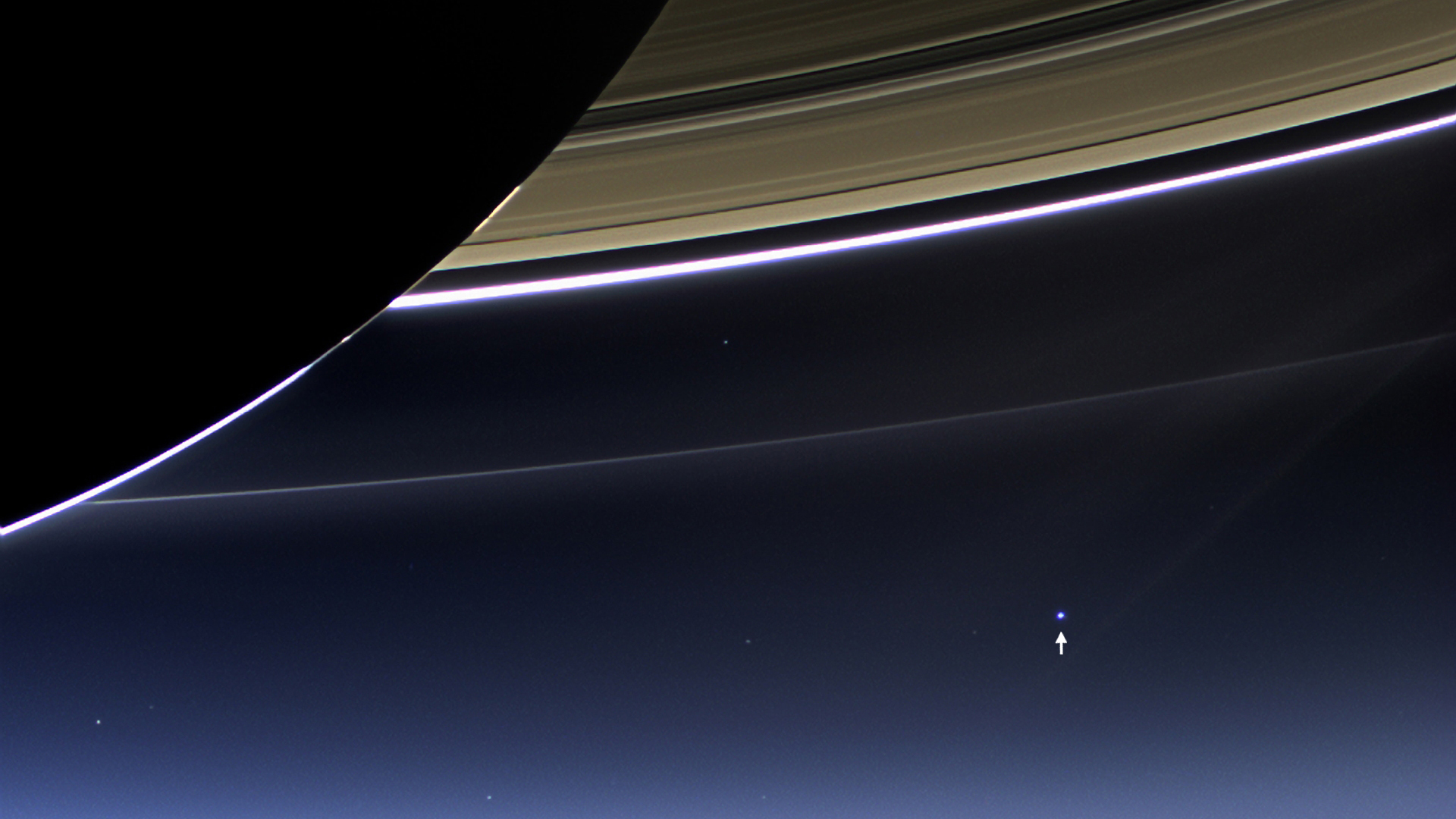
Tornado at Denver International Airport rated EF1

The tornado near DIA sent workers working on the terminal renovations scrambling.  (Rob Gardner)
The tornado near DIA sent workers working on the terminal renovations scrambling. (Rob Gardner)

The tornado that struck on the grounds of Denver International Airport (DIA) on Tuesday, June 18, 2013 has been rated an EF1 with winds up to 109 mph.  The twister came within a half mile of Concourses A and B and sent workers and travelers scrambling to tornado shelters.

Scroll down to see more photos of the tornado.

From the National Weather Service:

A tornado developed on Denver International Airport (DIA) grounds on the afternoon of June 18, 2013. The tornado formed around 2:19 PM just north of 70th Avenue. The tornado then moved slowly northwest between Runway 35R and 35L, and moved to within a half mile of Concourses A and B before dissipating at 2:36 PM. The tornado moved extremely close if not over the ASOS (Automated Surface Observation System) and another low level wind shear sensor at DIA. The ASOS weather observing system reported a 97 mph wind gust at 2:27 PM, while the wind shear sensor reported a wind gust to 109 mph at the same time – indicative of an EF1 tornado. There was only minor damage noted to this equipment. The storm responsible for this tornado first developed just south of the airport, and then drift slowly northward across the eastern side of DIA. At 2:05 PM, there was weak rotation beginning to develop underneath this storm as noted by the velocity data below. This rotation then strengthened quickly between 2:10 and 2:22 PM.

Military deploys firefighters, aircraft to battle exploding Colorado wildfires

For the second year in a row tinder dry conditions have allowed explosive wildfire growth in Colorado and once again the United States military is deploying resources to assist local firefighting efforts. Among the forces being called into action are massive Modular Airborne Fire Fighting System (MAFFS) C-130 Hercules aircraft.  Read the rest of this story on Examiner.com including a video update on the Black Forest Fire

Among assets the U.S. military is deploying to battle wildfires in Colorado are MAFFS C-130s. (U.S. Air Force)


Wildfires erupt across Colorado prompting evacuations, burning homes

As the second of two days of record-setting temperatures started to come to a close, the tinder dry landscape in Colorado erupted in flame. Tuesday afternoon multiple blazes from the state’s south border to near the north sent residents scrambling to escape the advancing flames.  Read the rest of this story on Examiner.com

Pyrocumulus clouds from the Black Forest Fire are seen from Colorado Springs on Tuesday, June 11, 2013.
Pyrocumulus clouds from the Black Forest Fire are seen from Colorado Springs on Tuesday, June 11, 2013. (Teri & Matt Bertrand)

Extreme heat shatters four temperature records in two days in Denver

Under a stubborn area of high pressure the Mile High City has been sweltering with unseasonably hot temperatures. The past two days saw four temperature records be broken as the mercury climbed to regions more akin to the middle of summer than June.  Thornton fell just shy of 100° today reaching “only 99°.  Officially though Denver hit the mark.  Read the rest of this story on Examiner.com

Denver, Colorado saw record-breaking heat with temperatures more like what was expected in July than early June.

Denver breaks two temperature records for June 10

Record setting high temperatures in Thornton.Under the influence of strong high pressure, the mercury soared in the Mile High City on Monday and two temperature records fell.

As measured at Denver International Airport, the mercury reached a high of 99 degrees at 2:53 p.m.  This broke the previous record high temperature for June 10 of 97 degrees set in 1952.

Here in Thornton we were hot but not quite as hot.  Our high temperature topped out at 97 degrees at 2:35 p.m.  This is the highest temperature we have seen thus far this year and the highest reading in Thornton since July 21, 2012 (97.9 degrees).

If you thought the nighttime would bring relief from the heat, you were mistaken.  Denver’s official “low” temperature on Monday was only 68 degrees.  This set a new record high minimum for the date easily besting the previous record holder of  64 degrees last set in 1990.  Thornton was just slightly cooler with a low for the date of 66.8 degrees.

There won’t be much of a break in the heat in the coming days.  While it will be cooler than today, temperatures for the rest of the week are expected to continue to be well above normal.  Get the latest forecast here.

NASA satellite video showcases deadly Tornado Alley severe weather outbreak

Severe weather season had been relatively quiet during the first four months of 2013 but with the arrival of May Mother Nature unleashed her full fury. New satellite video released by NASA yesterday captures the last week of the month when tornadoes virtually exploded across the nation’s midsection.  Read the rest of this story on Examiner.com and / or click on the image below to view the video.

A person looks at cars damaged by a powerful tornado on June 1, 2013 in El Reno, Oklahoma. The tornado ripped through the area killing at least 9 people and injuring many and destroyed homes and buildings.
A person looks at cars damaged by a powerful tornado on June 1, 2013 in El Reno, Oklahoma. The tornado ripped through the area killing at least 9 people and injuring many and destroyed homes and buildings. Click the image to view a video of NASA satellite imagery of the deadly weather.

2013 hurricane season begins: Tropical Storm Andrea set to hit Florida

The unofficial start of the Atlantic hurricane season is June 1 and Mother Nature has wasted no time in delivering its first named storm. Tropical Storm Andrea has formed in the Gulf of Mexico and is expected to make landfall in Florida Thursday afternoon or evening. Get the complete story with forecast track maps, video and more on Examiner.com

Tropical Storm Andrea became the first named storm of the 2013 hurricane season and will make landfall in Florida on Thursday.
Tropical Storm Andrea will hit Florida on Thursday bringing wind, rain and storm surge. Click the image to view a slideshow of the storm’s forecast track and this morning’s satellite imagery.


WeatherNation deploys to Denver market in partnership with 9NEWS

Denver-based WeatherNation programming will now be seen on KUSA's digital channel 9.2 and COMCAST channel 249.WeatherNation TV has long been a ‘best kept secret’ for those seeking weather news and information without the unrelated programming offered by that other weather channel. Now the company has broken into the Denver television market with a partnership with 9NEWS KUSA extending their reach in their home city.

Once upon a time there was a cable network that could be trusted for weather news but that channel has strayed far from their roots and are but a shadow of their former selves.

Now, with WeatherNation TV, there is an alternative with 24/7 weather as it should be.   ThorntonWeather.com is happy to see them arrive in the Mile High City.  Get more details on where you can watch WeatherNation TV in this story on Examiner.com.

May 2013 weather recap: Drier, warmer weather return

Following on colder and wetter than normal weather in previous months, Thornton’s May returned us to drier and warmer than normal conditions.

The month started out with a bit of a wintry blast of cold temperatures and snow.  In fact, Denver even set an all-time May low temperature on the 2nd of the month.

The cold and snow that started the month were probably overall the most notable feature of the month.  The rest of May was not particularly extraordinary in any aspect.

Denver’s average temperature for the month was 57.9 degrees.  This was 0.8 degrees above average.  Here in Thornton we were just slightly cooler with an average temperature of 57.6 degrees.

Thornton’s temperatures ranged from a high of 89.2 degrees on the 14th down to a low of 20.7 degrees on the morning of the 2nd.  Denver saw a maximum temperature of 88 and a low of 19 degrees.

Official Denver temperature records for the month included:

DAILY RECORDS:

DATE        TEMPERATURE     TYPE OF RECORD     OLD RECORD   YEAR LAST SET
MAY 2ND     19 DEGREES        RECORD LOW       22 DEGREES       1954
MAY 14TH    87 DEGREES     TIED RECORD HIGH    87 DEGREES       1996

MONTHLY RECORDS:

DATE        TEMPERATURE     TYPE OF RECORD     OLD RECORD   YEAR LAST SET
MAY 2ND     19 DEGREES      TIED RECORD LOW    19  DEGREES   MAY 3RD 1907

In terms of precipitation, Denver recorded only 0.82 inches, far below the average for May of 2.12 inches.  Here in Thornton Mother Nature was far more generous as we recorded 2.35 inches.

The snow that started the month totaled 4.3 inches in Thornton, 3.4 inches in Denver.  Both were well above the May average of 1.1 inches snowfall.

Click here to view the ThorntonWeather.com May 2013 Climate Summary

Thornton, Colorado May 2013 Temperatures.
Thornton, Colorado May 2013 Precipitation.

Weather, natural disasters & climate news and information.