This year on September 3 Denver reached an official high temperature of 94 degrees. Here in Thornton we topped out at 95 degrees.
Providing a stark contrast is a look back at this date 52 years ago.
On September 3, 1961 a winter-like system delivered 4.2 inches of snow to the Mile High City with the foothills receiving a foot of the white stuff. This is the earliest date for a seasonal snowfall on record. Temperatures that day dropped to 33 degrees, the earliest in the season it has ever been that cold.
The comparison highlights the extremes that Colorado can experience in September (much like most other months). Which would you prefer? Heat or snow?
Progress battling the massive Rim Fire has been slow to come and while some gains have been made, the blaze continued to grow and now encompasses more than 280 square miles. The blaze has already intruded on Yosemite National Park and were perilously close to its infamous giant sequoia trees. Park officials were placing sprinklers in two groves of sequoias not far from the fire.
A firefighter uses a hose to douse the flames of the Rim Fire on August 24, 2013 near Groveland, California. (Getty Images) Click the image to view a slideshow from the Rim Fire.
Former vice president Al Gore has made more than his fair share of misstatements while acting as the most visible spokesperson for climate change alarmism. In his latest, Gore makes a false claim that hurricanes are becoming so strong that a new Category 6 classification is coming. Read more about the former VP’s latest misstep on Examiner.com
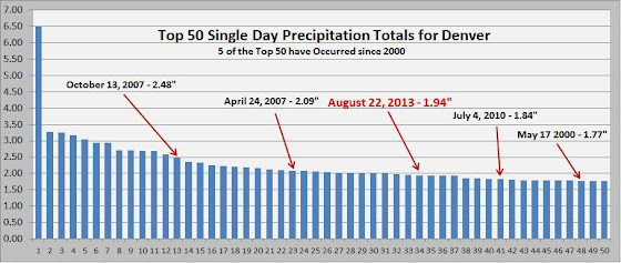
Mother Nature can be fickle, especially in Colorado, dropping heavy rain in one location and nothing in a spot nearby. Such was the case this afternoon and evening when Denver International Airport received nearly two inches of rain and Thornton recorded nothing.
As officially measured at DIA, Denver recorded an amazing 1.94 inches of precipitation on August 22. This easily bests the record for the date of 0.75 inches set in 1953. It also ranks as the 34th biggest single day precipitation total for the city on record.
Here in Thornton we weren’t so lucky as the storms stayed south and east of us. We recorded absolutely nothing in the rain bucket on this date.
Denver’s Top 50 Single Day Precipitation Totals (National Weather Service)
The lowest temperature today was a very mild 70 degrees at 1:50 a.m. This is a new record high minimum for August 20 easily besting the old record of 67 degrees set in 2007 and previous years.
Denver officially set another high temperature record. However, is it accurate to compare measurements taken at DIA with historical records taken 14 miles away?
Summer 2013 had been a relatively cool one – up until this latter half of August. The Mile High City set another record high temperature and while it was assuredly hot, questions continue to arise over the comparison of measurements at DIA with Denver’s historical records.
At 1:34 p.m. the mercury climbed to 99 degrees at Denver International Airport. This beats the previous record high temperature for the date of 98 degrees set in 1987 at the old Stapleton International Airport.
Here in Thornton we were just a bit cooler with the mercury topping out at 97.8 degrees at 2:23 p.m. This was in fact our second highest temperature of the year. On June 11 we measured 99.2 degrees. Click here to view Thornton’s 2013 temperature records.
At midnight tonight we may see yet another record fall. The record high minimum for today’s date is 67 degrees. This morning the temperature only dropped to 71 degrees at DIA. If by midnight we don’t drop to the 67 degree mark, that will be another record for the Mile High City.
Today’s record is the third in the past four days. On Sunday, August 18 we tied the record high for that date of 98 degrees. That followed a record-breaker on Saturday the 17th when the mercury topped 97 degrees, breaking the old record for that date of 96 degrees.
One thing these records do continue to teach us is how invalid it is to compare records at Denver International Airport compared to historical locations where Denver’s official temperature was measured prior to 1994.
Today for instance, the station at Denver City Park recorded 97 degrees.
Hot yes. Record-setting no.
Similarly, on Sunday the 18th City Park recorded 95 degrees versus DIA’s mark of 98 degrees. On Saturday when DIA recorded a record-breaking 97 degrees, City Park saw 96 degrees.
The difference in measurements is something we have seen repeatedly since 1994. The move of Denver’s official monitoring station is corrupting the city’s climate record and has wide implications.
With a location 14 miles east of where official temperatures were measured prior to DIA, it is in an entirely different microclimate and as a result it experiences different conditions – sometimes considerably different – to locations closer to downtown.
If we can’t accurately compare our temperatures, how are we to believe climate change alarmists that warn of global warming?
For more on the topic of Denver’s problematic weather station, see these previous stories:
Despite dire warnings from climate change alarmists, one measure of ‘extreme weather’ has seen an exceptionally quiet year – tornadoes. The latest data on tornadoes in the United States from NOAA’s Storm Prediction Center (SPC) shows a distinct lack of one of Mother Nature’s most devastating phenomena in 2013. The measurements, as well as others, have confounded those who have warned that anthropogenic global warming would lead to more devastating natural disasters.
At 3:08 p.m. the mercury climbed to 98 degrees. The last time the date saw readings that high was in 2011.
Here in Thornton we were a bit cooler – but not by much. Our temperature topped out at 95 degrees at 3:19 p.m. This mirrored our high temperature yesterday.
We expect at least a couple more days of these well-above normal temperatures as we head into the workweek. After that we should start to cool down a bit. Click here to view the extended forecast.
Don’t miss a thing when it comes to our ever changing weather! Be sure to ‘like’ us on Facebook, follow us on Twitter and add us to your Google+ circles.
The mercury climbed with great efficiency today leading to a record-breaking temperature for the date. As measured at Denver International Airport, Denver’s temperature topped out at 2:28 p.m. reaching 97 degrees. This breaks the old record for August 17 of 96 degrees set most recently in 1994.
Here in Thornton we were a bit cooler – but not by much. Our temperature topped out at 95 degrees at 2:43 p.m.
Above normal temperatures, but probably not record-setting, are expected to stay with us through at least the first half of the week. Tomorrow and Monday do offer just a slight chance for thunderstorms. Click here to view the extended forecast: http://www.thorntonweather.com/forecast.php
Don’t miss a thing when it comes to our ever changing weather! Be sure to ‘like’ us on Facebook, follow us on Twitter and add us to your Google+ circles.
The Nike Weatherman Pack is a series of shoes from the popular athletic wear maker inspired by Doppler radar. Click the image to view a slideshow of the new sneakers. (Nike)
Weather, natural disasters & climate news and information.
")


 Not to be entirely outdone by
 ")