It was sure slow coming with most of the day featuring a light rain / snow mix. At about 4:00pm the snow finally began in earnest. The video below was taken from the ThorntonWeather.com backyard.
National Weather Service announces storm spotter training dates for 2014

Severe weather is a fact of life in Colorado – from blizzards to tornadoes we can and do see it all. Each year the weather is responsible for claiming lives in our state and across the nation and the threat is very real. Storm spotter training allows you to learn how to protect yourself and your family while providing a public service.
Education is key to knowing how to protect you and your family. Whether you want to be an official storm spotter or maybe just want to learn more about severe weather, storm spotter training can provide you an incredible opportunity to learn.
The National Weather Service Denver / Boulder office has announced a series of Skywarn storm spotter training dates for Colorado for the 2013 season.
The storm spotter program is a nationwide program with more than 280,000 trained spotters. These volunteers report weather hazards to their local National Weather Service office providing vital information when severe strikes. Data from spotters include severe wind, rain, snow measurements, thunderstorms and hail and of course tornadoes.
Storm spotters are part of the ranks of citizens who form the Nation’s first line of defense against severe weather. There can be no finer reward than to know that their efforts have given communities the precious gift of time–seconds and minutes that can help save lives.
By completing one of these training classes you can become an official storm spotter. When severe weather strikes, you can report it by calling a special toll free number or submit your report via the National Weather Service’s website.
These are great sessions for anyone wanting to learn more about the severe weather we experience in Colorado, whether you want to be an official spotter or not. All training is free. Topics include:
- Basics of thunderstorm development
- Fundamentals of storm structure
- Identifying potential severe weather features
- Information to report
- How to report information
- Basic severe weather safety
To learn more about the program, see here: http://www.crh.noaa.gov/bou/awebphp/spotter.php
Below are the dates, times and locations announced thus far with the first occurring on Sunday, February 16. We will try to keep this updated but you can click here for any new dates on the National Weather Service website.
Schedule updated 4/6/14:
| April, 2014 – Upcoming | |||
| Day | City, State | Time | Location |
| 07 | Loveland, CO (Larimer County) |
9:00am MDT | The Rialto Theater 228 E. Fourth Street Loveland, Colorado 80537 |
| Contact Information: mialyp@ci.loveland.co.us | |||
| 07 | Fort Collins, CO (Larimer County) |
6:30pm MDT | Fort Collins Police Services Building, Community Service Room 2221 S. Timberline Drive Fort Collins Colorado |
| Contact Information: migavin@poudre-fire.org | |||
| 10 | New Raymer , CO (Weld County) |
6:30pm MDT | New Raymer Community Building 25 Shirley Ave. New Raymer, CO |
| Contact Information: dustin@dustinpricephotography.com | |||
| 12 | Kiowa, CO (Elbert County) |
9:00am MDT | Old County Courthouse Second floor, 215 Comanche Street, Kiowa, CO 80117 |
| Contact Information: brandon.lenderink@elbertcounty-co.gov | |||
| 14 | Akron, CO (Washington County) |
6:30pm MDT | Washington County Fairgrounds Event Center 551 E. Second Street, Akron, CO |
| Contact Information: mmccaleb@co.washington.co.us | |||
| 15 | Greeley, CO (Weld County) |
6:30pm MDT | Weld County Administration Building, 1150 O Street, Greeley, CO |
| Contact Information: gmarquez@co.weld.co.us | |||
| 19 | Commerce City, CO (Adams County) |
10:00am MDT | Sheriff’s Substation Conference Room, 4201 E. 72nd Ave., Commerce City, CO 80022 |
| Contact Information: r1@rampartsar.com | |||
| 21 | Centennial, CO (Arapahoe County) |
6:30pm MDT | Arapahoe County Sheriff, 13101 East Broncoes Parkway, Centennial, CO |
| Contact Information: awallin@arapahoegov.com | |||
| 24 | Aurora, CO (Arapahoe County) |
6:00pm MDT | Aurora Central Library 14949 E Alameda Pkwy, Aurora, CO 80012. |
| Contact Information: acox@auroragov.org | |||
| 26 | Strasburg, CO (Adams County) |
10:00am MDT | Strasburg Fire Department Conference Room, 56281 E. Colfax Ave., Strasburg, CO 80136 |
| Contact Information: tmccall@svfd8.org | |||
| 28 | Parker, CO (Douglas County) |
6:30pm MDT | Parker Police 18600 Lincoln Meadows Pkwy Parker, CO 80134 |
| Contact Information: khenry@parkeronline.org | |||
| 29 | Littleton, CO (Jefferson County) |
10:00am MDT | Foothills Park and Recreation District 6612 S. Ward Street, Littleton, CO 80127. |
| Contact Information: lisan@fhprd.org | |||
| 29 | Denver, CO (Denver County) |
7:00pm MDT | Red Cross facility 444 Sherman St., Denver Co |
| Contact Information: kc0mht@msn.com | |||
| May, 2014 – Upcoming | |||
| Day | City, State | Time | Location |
| 01 | Hugo, CO (Lincoln County) |
2:00pm MDT | Lincoln County Courthouse 103 3rd Street, Hugo, CO 80821 |
| Contact Information: lclanduse@lincolncountyco.us | |||
| 01 | Hugo, CO (Lincoln County) |
6:30pm MDT | Lincoln County Courthouse 103 3rd Street, Hugo, CO 80821 |
| Contact Information: lclanduse@lincolncountyco.us | |||
| 06 | Boulder, CO (Boulder County) |
6:30pm MDT | SHHQ TrainingRoom 5600 Flatiron Parkway, Boulder |
| Contact Information: fgonzales@bouldercounty.org | |||
| 08 | Thornton, CO (Adams County) |
6:00pm MDT | Thornton City Hall 1st Floor Training Room, 9500 Civic Center Drive, Thornton, CO 80229 |
| Contact Information: gene.putman@cityofthornton.net | |||
March 2014 weather recap: Month saw near normal temperatures and precip, below normal snowfall.
Looking back at the month of March we see a period of relatively uneventful weather in the Denver area. Temperatures were near normal as was the amount of liquid precipitation, this despite the fact we saw well below normal snowfall.
The month started very cold with the first two days failing to record readings above freezing and some light snowfall. That did not last long however and four mild days followed. A weak system then moved in with a couple more shots of snow over a three day period.
Entering the second week of the month temperatures moderated and we saw some of our warmest readings of the month. Light snow on the 12th fell but did not cool things down too much.
Two more very light snowfalls occurred in the last 10 days of the month while temperatures overall remained at or above normal.
Thornton’s average temperature for the month came in at 41.1 degrees, 0.7 degrees above the Denver average for March of 40.4 degrees. Out at Denver International Airport, the Mile High City saw an average monthly temperature of 40.9 degrees.
Our warmest temperature for the month occurred on the 9th when the mercury climbed to 75.0 degrees. The coldest reading of 3.8 degrees happened on March 2. Denver’s warmest and coldest temperatures were on the same days with readings of 73 degrees and 4 degrees.
Two days, the first and the second, saw high temperatures below freezing. Low temperatures below freezing occurred on 22 of the 31 days. Denver saw similar readings.
In terms of liquid precipitation, Thornton recorded 1.06 inches. This was a bit above Denver’s March average of 0.92 inches. Denver was drier than normal recording 0.83 inches.
The near normal precipitation came despite the fact we saw much less snow than normal. March is typically our snowiest with an average of 10.7 inches of the white stuff. Thornton saw a mere 6.5 inches and Denver 6.0 inches.
Click here to view Thornton’s March 2014 climate report.


CLIMATE REPORT...CORRECTED
NATIONAL WEATHER SERVICE BOULDER, CO
725 PM MDT TUE APR 1 2014

..............CORRECTED FOR TYPOS FOR THE FOLLOWING.................
.....TEMPERATURES...SNOWFALL DEPARTURES AND PEAK WIND DIRECTION.....

...................................

...THE DENVER CO CLIMATE SUMMARY FOR THE MONTH OF MARCH 2014...

CLIMATE NORMAL PERIOD 1981 TO 2010
CLIMATE RECORD PERIOD 1872 TO 2014

WEATHER         OBSERVED          NORMAL  DEPART  LAST YEAR`S
                 VALUE   DATE(S)  VALUE   FROM    VALUE  DATE(S)
                                          NORMAL
................................................................
TEMPERATURE (F)
RECORD
 HIGH              84   03/26/1971
 LOW              -11   03/28/1886
HIGHEST            73   03/09        84     -11       76  03/15
LOWEST              4   03/02       -11      15        2  03/25
AVG. MAXIMUM     55.8              54.4     1.4     50.7
AVG. MINIMUM     25.9              26.4    -0.5     24.6
MEAN             40.9              40.4     0.5     37.7
DAYS MAX >= 90      0               0.0     0.0        0
DAYS MAX <= 32      2               1.9     0.1        3
DAYS MIN <= 32     23              23.6    -0.6       24
DAYS MIN <= 0       0               0.1    -0.1        0
PRECIPITATION (INCHES)
RECORD
  MAXIMUM         4.56   1983
  MINIMUM         0.03   2012
TOTALS           0.83              0.92   -0.09     1.47
DAILY AVG.       0.03              0.03    0.00     0.05
DAYS >= .01         9               5.9     3.1        6
DAYS >= .10         2               2.4    -0.4        4
DAYS >= .50         0               0.3    -0.3        0
DAYS >= 1.00        0               0.1    -0.1        0
GREATEST
 24 HR. TOTAL    0.32   03/07 TO 03/07           03/22 TO 03/22
                                                          03/22 TO 03/22
                                                          03/22 TO 03/22
 STORM TOTAL       MM                                 MM
 (MM/DD(HH))            MM                    03/22(00) TO 03/22(00)
                                                 03/22(00) TO 03/22(00)2
                                                 03/22(00) TO 03/22(00)2

SNOWFALL (INCHES)
RECORDS
 TOTAL             MM   5
TOTALS            6.0              10.7

DEGREE_DAYS
HEATING TOTAL     739               763     -24      840
 SINCE 7/1       5258              5202      56     5112
COOLING TOTAL       0                 0       0        0
 SINCE 1/1          0                 0       0        0

FREEZE DATES
RECORD
 EARLIEST     09/08/1962
 LATEST       06/08/2007
EARLIEST                        10/07
LATEST                          05/05
...................................................

WIND (MPH)
AVERAGE WIND SPEED              11.5
RESULTANT WIND SPEED/DIRECTION   3/247
HIGHEST WIND SPEED/DIRECTION    45/350    DATE  03/18
HIGHEST GUST SPEED/DIRECTION    55/350    DATE  03/18

SKY COVER
POSSIBLE SUNSHINE (PERCENT)   MM
AVERAGE SKY COVER           0.60
NUMBER OF DAYS FAIR            6
NUMBER OF DAYS PC             18
NUMBER OF DAYS CLOUDY          7

AVERAGE RH (PERCENT)     50

WEATHER CONDITIONS. NUMBER OF DAYS WITH
THUNDERSTORM              0     MIXED PRECIP               0
HEAVY RAIN                0     RAIN                       2
LIGHT RAIN                3     FREEZING RAIN              0
LT FREEZING RAIN          1     HAIL                       0
HEAVY SNOW                0     SNOW                       6
LIGHT SNOW               10     SLEET                      0
FOG                      12     FOG W/VIS <= 1/4 MILE      5
HAZE                      5

-  INDICATES NEGATIVE NUMBERS.
R  INDICATES RECORD WAS SET OR TIED.
MM INDICATES DATA IS MISSING.
T  INDICATES TRACE AMOUNT.
Thornton’s April weather preview: Just about anything possible
 April marks a transition between winter and summer for most of the country but for Denver it is especially true as we can see a stunning variety of weather.
The proverbial April showers are certainly a possibility for Denver. Snow? Tornadoes? Thunderstorms? You bet – all can happen!
For good measure throw in a chance for hail and even dust storms and April gives every type of weather condition you could like – or hate.
March 2014 top shots: Monthly photo slideshow
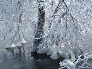
March along the Colorado Front Range can be a very pleasant time as temperatures climb with the approach to and arrival of spring. However the month is also Denver’s snowiest and wintry weather is not unusual. This variety of conditions will be reflected in our March 2014 slideshow below.
- Slideshow updated March 31, 2014
Showcasing images captured by ThorntonWeather.com readers as well as some of our own, our monthly slideshow covers the entire gamut of weather-related imagery. Sunsets, sunrises, wildlife and of course snow are vividly depicted.
Throughout the month we will gather the images sent to us via email or shared with us via our various social media outlets and post them in the slideshow below.
To learn more about getting your photos added to our monthly slideshow, click here.
Click the play button below and sit back and enjoy the images.
Magnitude 5.1 earthquake rattles Los Angeles area, causes minor damage
A significant magnitude 5.1 earthquake struck La Habra, California Friday breaking water mains, knocking items from shelves and rattling Los Angeles area residents.Occurring at 9:09 p.m., the US Geological Survey reported the quake was centered 4…

Read the rest of this story on Examiner.com
Before and after: NASA satellite imagery shows effects of Washington state landslide
As many as two dozen people were killed on Saturday, March 22, 2014 when a massive landslide swept down a rain-soaked hill near Oso, Washington. NASA satellite imagery taken before and after the event shows the extent of the event.
Using the ‘sliders’ on the image below you can compare how the area looks normally (left) versus how it looked after the landslide (right).
[wpw_ba_viewer width=”600″ height=”auto” anim_speed=”600″ start_percent=”0.5″ disable_intro=”false”]
[wpw_ba_img src=”http://lh6.googleusercontent.com/-I2mSOZBkFnQ/UzMQFKXi74I/AAAAAAAAB0s/tcA9N10o6cY/s600/wa-before.jpg” data_second=”http://lh5.googleusercontent.com/-VXmVfoDsFqQ/UzMQFPSNLNI/AAAAAAAAB0w/kIX2gla6sTA/s600/wa-after.jpg” title=”Satellite imagery comparison of the area near Oso, Washington before and after the March 22, 2014 landslide. (NASA EO)” data_info=”Satellite imagery comparison of the area near Oso, Washington before and after the March 22, 2014 landslide. (NASA EO)”]
[/wpw_ba_viewer]
From NASA:
On March 22, 2014, a rainfall-triggered landslide near Oso, Washington sent muddy debris spilling across the North Fork of the Stillaguamish River. The debris engulfed numerous homes, resulting in the deaths of at least 14 people. As of March 25, authorities reported that 176 people were still missing.
The slide left an earthen dam that blocked the river, causing a barrier lake to form. The Operational Land Imager (OLI) on Landsat 8 acquired this image of landslide debris and the barrier lake on March 23, 2014. An image of the same area acquired on January 18, 2014, is shown for comparison.
As water backed up, it raised fears of a potential flash flood. On March 23, water began to flow around the north side of the dam. However, as of the afternoon of March 25, a flash flooding watch issued by the National Weather Service remained in effect for parts of Snohomish county.
According to Durham University geologist Dave Petley, the landslide was a reactivation of an earlier landslide that caused problems in 1988 and 2006.
Video: Dust devil strikes during controlled burn at Rocky Mountain Arsenal
 Performing prescribed burns is an important way to clear brush and renew wildland and are often done without any excitement. Mother Nature had other plans last week however as whirling winds propelled a fire beyond its containment lines at the Rocky Mountain Arsenal National Wildlife Refuge.
The amazing video of the event on March 14 was taken by a firefighter from South Metro Fire and showcases how quickly weather conditions can change and how even when well-planned, fires can quickly get out of control.
- Story republished with permission from the Denver Weather Examiner
The fire is seen burning through the grasslands of the refuge when swirling wind develops – a common phenomenon caused by the heat quickly rising from the fire. Soon the fire begins to rage and tumbleweeds and burning debris are sent flying in a circular path.
Thomas Rogers, the man behind the camera, said on YouTube the fire burned an additional acre as crews backed off to gain the upper hand.
Refuge Manager David Lucas said on Facebook, “What we saw and how we reacted is exactly what we want out of our fire crews — well planned with plenty of on-site resources to manage contingencies, safety first, and well trained folks who got after it quickly.”
Satellite imagery provides bird’s eye view of Earth at the change of seasons
Satellite imagery provides bird’s eye view of Earth at the change of seasons.
Pretty neat imagery and explanation from NASA:
Enjoy the Equinox!
Every year, there are two equinoxes. One is in March; the other is in September. In 2014, the March equinox falls on March 20, 2014. On the equinoxes, the sun shines directly on the equator and the length of day and night is nearly equal. Seasons are opposite on either side of the equator, so the March equinox is called the spring (or vernal) equinox in the northern hemisphere. But in the southern hemisphere, it’s known as the fall (autumnal) equinox. What do equinoxes look like from space? The Spinning Enhanced Visible and Infrared Imager (SEVIRI) on EUMETSAT’s Meteosat-9 captured these four views of Earth from geosynchronous orbit. The images show how sunlight fell on the Earth on December 21, 2010 (upper left), and March 20 (upper right), June 21 (lower left), and September 20, 2011 (lower right). Each image was taken at 6:12 a.m. local time. Notice how on March 20 and September 20, the terminator — the divide between day and night — is a straight north-south line, and the Sun is said to sit directly above the equator. Equinox means “equal night” in Latin, capturing the idea that daytime and nighttime are equal lengths everywhere on the planet.
Read more about the equinoxes and solstices at
http://
See a video of the equinoxes and solstices from space at
http://www.youtube.com/
Read more about the March Equinox from Date and Time at
http://

Announcing Tony’s Takes Photography

I have always been a shutterbug ever since my parents gave me my first SLR one Christmas when I was in high school. It wasn’t until recent years however that I began to hone the craft and now I have launched Tony’s Takes Photography.
Certainly I have no illusion of becoming a professional photographer or having the skills of one. This is purely a hobby for me. However I think I do a pretty passable job and decided I would like to share my images. Up until now that has been confined to this website and on social media with friends and family.
Over at Tony’s Takes (www.tonystakes.com) I will be sharing the images I capture. These will usually be focused on the subjects which interest me most – extreme weather, landscapes and wildlife. Certainly some of these photos will make their way here as always but that will be the primary spot where I post them.
Don’t worry though. Weather is still a passion of mine andThorntonWeather.com will be staying around as always and remaining your one and only spot for truly local Thornton weather news and information!
You can find Tony’s Takes Photography at any of the links below and I would truly appreciate you spreading on the work:
