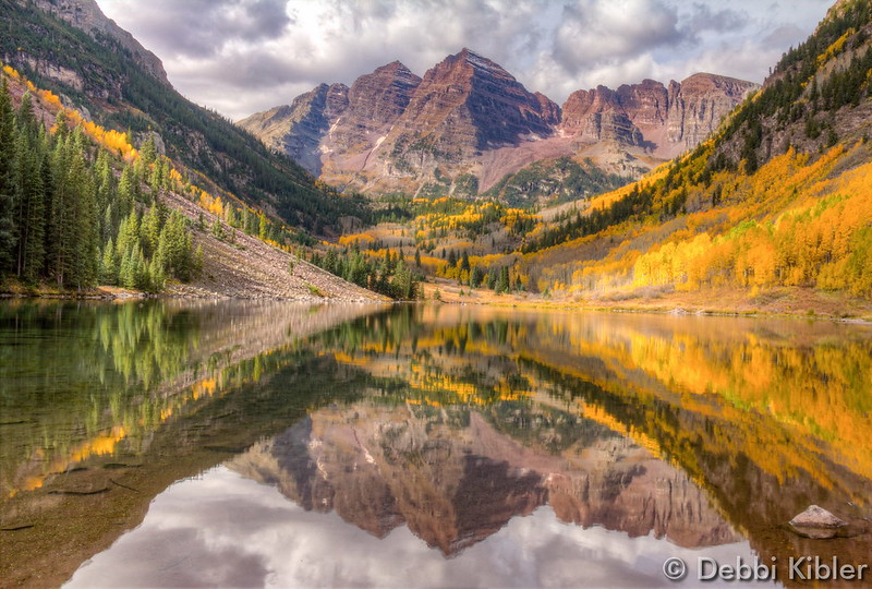
October 2015 top shots: Monthly photo slideshow

A classic fall image of the Maroon Bells. (Debbi Kibler)

October in Thornton can bring a wide variety of weather conditions, perfect for the photographer in all of us.

The month brings the changing of the colors at Colorado’s lower elevations and it is also is typically when we see our first freeze and first snow.

Couple those facts with our usual widely varying landscapes and wildlife and we have a month that is sure to bring in plenty of photo opportunities.

  • Slideshow updated November 1, 2015
  • To learn more about how to send your photo to us for inclusion in the slideshow, see below the slideshow.

Showcasing images captured by ThorntonWeather.com readers as well as some of our own, our monthly slideshow covers the entire gamut of weather-related imagery.

Sunsets, sunrises, wildlife and of course every type of weather condition are vividly depicted in images captured from yours and our cameras.

[flickr_set id=”72157659177525310″]

What is missing in the slideshow above?  Your photo!

Our monthly photo slideshow is going to feature images that we have taken but more importantly images that you have captured.  The photos can be of anything even remotely weather-related.

Landscapes, current conditions, wildlife, pets, kids.  Whimsical, newsy, artsy.  Taken at the zoo, some other area attraction, a local park, a national park or your backyard.  You name it, we want to see and share it!

Images can be taken in Thornton, Denver or anywhere across the extraordinary Centennial State.  We’ll even take some from out of state if we can tie it to Colorado somehow.

We’ll keep the criteria very open to interpretation with just about any image eligible to be shown in our slideshows.

What do you win for having your image in our slideshow?  We are just a ‘mom and pop’ outfit and make no money from our site so we really don’t have the means to provide prizes.  However you will have our undying gratitude and the satisfaction that your images are shared on the most popular website in Thornton.

To share you images with us and get them included in the slideshow just email them to us or share them with ThorntonWeather.com on any of the various social media outlets.  Links are provided below.

So come on, get those camera’s rolling!

Falling back: Daylight Saving Time comes to an end Sunday morning

The United States returns to Standard Time at 2:00am Sunday as Daylight Saving Time comes to an end.

The biannual ritual of changing our clocks to adjust for Daylight Saving Time occurs tonight providing yet another signal of the changing of seasons.  The United States will ‘fall back’ one hour at 2:00am Sunday morning as we return to Standard Time.

The ritual of changing our clocks twice a year can be met with some resistance as some people struggle to adjust their body’s internal clock.  Others actually like the return to standard time as they get to enjoy an extra hour of sleep.

The time change definitely has big effects on the dawning of daylight and how early it gets dark in the evening.

Sunrise on Saturday occurs at 7:27am but on Sunday it will be at 6:28am. Similarly, sunset will occur at 5:59pm on Saturday but on Sunday the sun will disappear over the horizon at 4:58pm.

For many this means that when they get home from work it will now be dark and outdoor activities will be significantly curtailed as a result.

Arizona and Hawaii are the only states that do not observe Daylight Saving Time and remain on Standard Time year round.    The U.S. territories of Puerto Rico, American Samoa, Guam, Northern Mariana Islands, and the United States Virgin Islands also do not observe the event.

It won’t be all that long though before Daylight Saving Time returns.  On March 13, 2016 we will ‘spring forward.’

Daylight Saving Time Schedule

The mandated beginning and end of Daylight Saving Time has changed in the United States over the years.

The most recent schedule was set by the Energy Policy Act of 2005 and took effect in 2007.  We now ‘spring forward’ to begin Daylight Saving Time on the second Sunday in March and ‘fall back’ with the return to Standard Time on the first Sunday in November.

Year DST Begins 2 a.m.
(Second Sunday in March)
DST Ends 2 a.m.
(First Sunday in November)
2015 8 March 2015 1 November 2015
2016 13 March 2016 6 November 2016
2017 12 March 2017 5 November 2017
2018 11 March 2018 4 November 2018
2019 10 March 2019 3 November 2019
2020 8 March 2020 1 November 2020
2021 14 March 2021 7 November 2021
2022 13 March 2022 6 November 2022

Happy birthday! ThorntonWeather.com enters 10th year of operation

Keeping an eye on the sky since October 2006. ThorntonWeather.com is now beginning its 10th year of operation.

It is hard to believe but it was on October 25, 2006 the digital switch was thrown and the first bits of live weather data from our weather station were fed to the Internet.  ThorntonWeather.com was born!

Since that date, we are extremely proud of what the site has become – an indispensable community resource for north Denver metro area residents, businesses and governmental agencies.

On the one year anniversary of the site’s launch, we were receiving on average 750 unique visitors a month.  On the second anniversary that had grown to around 5,000 visitors a month.  For 2015 we are on pace to average well over 25,000 per month!

The response has been absolutely overwhelming to say the least.

We launched the site simply because we wanted to know what was going on with the weather in Thornton and the north Denver metro area.  We don’t live downtown, we don’t live at DIA and the differences in weather between Thornton and those other locations can be considerable.  Apparently many of you agree!

Our site has not only grown in terms of visitors, but perhaps more importantly in terms of the amount of information available.  Certainly we provide the basics of live weather conditions, radar and forecasts.

  • Did you know ThorntonWeather.com is a completely non-profit venture run by a Thornton resident?  We are self-funded but do occasionally receive help from members of the community, something which allows us to keep things up and running. Learn more about how you can help here.

Far more than that, we now have educational information about various weather dangers, historical climate information, satellite imagery, webcams and so much more.  Our news and blog section is continually updated with the latest news and information including items important to the community.

Put simply, there is no other media outlet in the state that provides as much weather news, information and content as we do!

Since our launch we have became very ‘social’ with a growing Facebook page, a Twitter feed and a presence on Google +.  Interacting with our visitors is an integral part of our site and something we enjoy greatly.

  • Stay up to date with Thornton’s weather: Be sure to ‘like’ us on Facebook, follow us on Twitter and add us to your Google+ circles.

We’re just ‘weather geeks’ that love the weather and love our community.  Running ThorntonWeather.com can be a bit expensive and it is time consuming to maintain and operate it but it is worth it.

We’d like to thank all of our visitors for your support in the past and we look forward to continuing to be the best, truly local source for Thornton weather.

Major Earthquake Rocks Southeast Asia

A massive 7.5 magnitude earthquake hit Afghanistan Monday, with its effects felt in parts of Pakistan and India, as well. The earthquake’s epicenter hit Jarm, Afghanistan, a city about 150 miles from Kabul. More than 52 people were killed in Afghanistan and Pakistan, according to local news outlet Dawn, with Al Jazeera reporting casualty tolls higher… Continue reading Major Earthquake Rocks Southeast Asia →

California governor’s attempt to link climate change and wildfires disputed by scientists

What do meteorologists know about climate change?It is a familiar refrain from climate change alarmists:  This latest wildfire (or hurricane or tornado or rain event) is the worst we have ever seen and manmade climate change is to blame.  The fact is though that these over-the-top claims rarely are true.

Certainly California has seen some devastating wildfires this season.  Governor Jerry Brown was quick to jump on the ‘blame climate change’ bandwagon.

With the Rocky Fire still smoldering in northern California, the governor used his bully pulpit to push his agenda:

“California is burning,” the governor dramatically declared. “What the hell are you going to do about it?

“This is a wake-up call. We have to start coming to our senses. This is not a game of politics. We need to limit our carbon pollution. These are real lives and real people. This problem cannot be solved year by year.”

“The fires are changing…. The way this fire performed, it’s not the way it usually has been. Going in lots of directions, moving fast, even without hot winds.”

Governor Brown’s statements do sound dire and make one believe that the wildfires and their behavior are unprecedented.  However, as the LA Times reported yesterday, the link between the blazes and climate change is tenuous at best.

But scientists who study climate change and fire behavior say their work does not show a link between this year’s wildfires and global warming, or support Brown’s assertion that fires are now unpredictable and unprecedented. There is not enough evidence, they say.

University of Colorado climate change specialist Roger Pielke said Brown is engaging in “noble-cause corruption.”

Pielke said it is easier to make a political case for change using immediate and local threats, rather than those on a global scale, especially given the subtleties of climate change research, which features probabilities subject to wide margins of error and contradiction by other findings.

“That is the nature of politics,” Pielke said, “but sometimes the science really has to matter.”

Historical fire suppression policies and land management are considered to be far larger concerns and are more likely to have contributed to the wildfires.

Wildfires are of course not the only natural disaster that gets blamed on climate change.  Indeed, many have blamed the Golden State’s drought on global warming but there is little evidence to back the claim.  In a study, NOAA said, “natural oceanic and atmospheric patterns are the primary drivers behind California’s ongoing drought.”

Despite the facts that show these events are cyclical and natural, you can be assured political leaders and activist scientists will continue to use them to push their climate change agenda.

NOAA Winter Outlook: Little clarity as to El Niño’s impact on Thornton

Temperature - U.S. Winter Outlook: 2015-2016.  Click for larger view. (NOAA)
Temperature – U.S. Winter Outlook: 2015-2016. Click for larger view. (NOAA)

NOAA’s Climate Prediction Center released their 2015-2016 winter outlook this morning and while a strong El Niño will play a factor in some parts of the nation, its effects here are less clear.

As we have written about before, Colorado’s geographical location well inland, shelters it some from the effects of warm, Pacific waters.   Overall snowfall in Colorado during El Niño years has not trended greatly one way or another.  We have however seen some of our largest storms during El Niño.

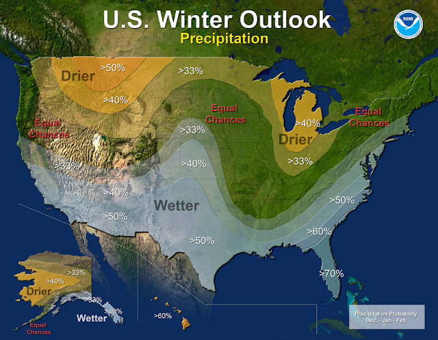
NOAA’s outlook shows a pretty typical El Niño situation with some locations of the nation expected to receive copious amounts of moisture.  For us, it does point to a bit better chance of a wetter than normal period from December to February.

Read the complete text of NOAA’s outlook below.  At the bottom is the video they released to accompany it.

From NOAA:

Precipitation - U.S. Winter Outlook: 2015-2016. Click for larger view. (NOAA)
Precipitation – U.S. Winter Outlook: 2015-2016. Click for larger view. (NOAA)

Forecasters at NOAA’s Climate Prediction Center issued the U.S. Winter Outlook today favoring cooler and wetter weather in Southern Tier states with above-average temperatures most likely in the West and across the Northern Tier. This year’s El Niño, among the strongest on record, is expected to influence weather and climate patterns this winter by impacting the position of the Pacific jet stream.

“A strong El Niño is in place and should exert a strong influence over our weather this winter,” said Mike Halpert, deputy director, NOAA’s Climate Prediction Center. “While temperature and precipitation impacts associated with El Niño are favored, El Niño is not the only player. Cold-air outbreaks and snow storms will likely occur at times this winter. However, the frequency, number and intensity of these events cannot be predicted on a seasonal timescale.”

Other factors that often play a role in the winter weather include the Arctic Oscillation, which influences the number of arctic air masses that penetrate into the South and nor’easters on the East Coast, and the Madden-Julian Oscillation, which can impact the number of heavy rain storms in the Pacific Northwest.

The 2015 U.S. Winter Outlook (December through February):

Precipitation Outlook:

  • Wetter-than-average conditions most likely in the Southern Tier of the United States, from central and southern California, across Texas, to Florida, and up the East Coast to southern New England. Above-average precipitation is also favored in southeastern Alaska.
  • Drier-than-average conditions most likely for Hawaii, central and western Alaska, parts of the Pacific Northwest and northern Rockies, and for areas near the Great Lakes and Ohio Valley.

Temperature Outlook:

  • Above-average temperatures are favored across much of the West and the northern half of the contiguous United States. Temperatures are also favored to be above-average in Alaska and much of Hawaii. Below-average temperatures are most likely in the southern Plains and Southeast.

Drought Outlook:

  • The U.S. Drought Outlook shows some improvement is likely in central and southern California by the end of January, but not drought removal. Additional statewide relief is possible during February and March. Drought removal is likely across large parts of the Southwest, while improvement or removal is also likely in the southern Plains. However, drought is likely to persist in the Pacific Northwest and northern Rockies, with drought development likely in Hawaii, parts of the northern Plains and in the northern Great Lakes region.

While it is good news that drought improvement is predicted for California, one season of above-average rain and snow is unlikely to remove four years of drought,” said Halpert. “California would need close to twice its normal rainfall to get out of drought and that’s unlikely.”

This seasonal outlook does not project where and when snowstorms may hit or provide total seasonal snowfall accumulations. Snow forecasts are dependent upon the strength and track of winter storms, which are generally not predictable more than a week in advance.

NOAA produces seasonal outlooks to help communities prepare for what’s likely to come in the next few months and minimize weather’s impacts on lives and livelihoods. Empowering people with actionable forecasts and winter weather tips is key to NOAA’s effort to build a Weather-Ready Nation.

NOAA’s mission is to understand and predict changes in the Earth’s environment, from the depths of the ocean to the surface of the sun, and to conserve and manage our coastal and marine resources. Join us on Facebook, Twitter, Instagram and our other social media channels.

Philippines braces for Typhoon Koppu

Manila (dpa) – Philippine authorities on Friday prepared evacuation plans and deployed emergency teams and relief supplies as Typhoon Koppu barrelled towards the country’s north-eastern coast. Koppu was packing maximum winds of 130 kilometres per hour (kph) and gusts of up to 160 kph as it moved west at a speed of 15 kph, the weather… Continue reading Philippines braces for Typhoon Koppu →

El Niño Won’t Relieve West’s Drought, NOAA Predicts

Updated | Federal weather forecasters released their winter outlook Thursday, and it doesn’t look good for drought-stricken northern California, Oregon and Washington state. A strong El Niño this winter is predicted to intensify the Western drought through at least January, the National Oceanic and Atmospheric Administration announced. Earlier this week, NASA released a new image of… Continue reading El Niño Won’t Relieve West’s Drought, NOAA Predicts →

Denver breaks record high temperature for October 11

Record setting high temperatures in Thornton.Temperatures this weekend were more akin to what we expect in August than what we normally see in the second week of October.  That bears out with the fact we broke the all-time record high temperature for today’s date.

At 1:46pm the temperature at Denver International Airport, Denver’s official station, topped out at 87 degrees.  This easily bests the previous record high for October 11 of 85 degrees recorded in 1996 and 1975.

Here in Thornton, we matched the 87 degree reading at 2:28pm.

The extended forecast does provide for cooler temperatures for the rest of the week, however they will continue to be a good bit above average for this time of year.  Get the extended forecast here.

  • Stay up to date with Thornton’s weather: Be sure to ‘like’ us on Facebook, follow us on Twitter and add us to your Google+ circles.

NASA Outlines Plan For Humanity’s Journey To Mars

Mars, despite its inhospitable climate and heavily irradiated surface that would kill humans in a matter of minutes, has been a source of unending fascination for scientists and science fiction writers alike. In recent years, this fascination has translated into concrete plans for a manned mission to the red planet, with the goal of eventually establishing… Continue reading NASA Outlines Plan For Humanity’s Journey To Mars →

Weather, natural disasters & climate news and information.