Tag Archives: CPC

NOAA releases 2016 – 2017 winter weather outlook

What will this winter have in store for Thornton?  Forecasters at the Climate Prediction Center have released their outlook and for the Front Range, it doesn’t hold much in the way of clues.

The CPC does show odds favor above average temperatures for much of Colorado for the period from December through February.  In terms of precipitation, the agency gives equal chances of near average, well above average, or well below average precipitation for most of the state. The one exception is the southern third of Colorado which they peg at having above average chances of a drier than normal year.

From NOAA:

U.S. Winter Outlook predicts warmer, drier South and cooler, wetter North
Drought expected to persist in California and expand in the Southeast

Winter 2016 - 2017 temperature outlook. Click for larger view. (NOAA)
Winter 2016 – 2017 temperature outlook. Click for larger view. (NOAA)

October 20, 2016 – Forecasters at NOAA’s Climate Prediction Center issued the U.S. Winter Outlook today, saying that La Nina is expected to influence winter conditions this year. The Climate Prediction Center issued a La Nina watch this month, predicting the climate phenomenon is likely to develop in late fall or early winter. La Nina favors drier, warmer winters in the southern U.S and wetter, cooler conditions in the northern U.S. If La Nina conditions materialize, forecasters say it should be weak and potentially short-lived.

“This climate outlook provides the most likely outcome for the upcoming winter season, but it also provides the public with a good reminder that winter is just up ahead and it’s a good time to prepare for typical winter hazards, such as extreme cold and snowstorms,” said Mike Halpert, deputy director, NOAA’s Climate Prediction Center. “Regardless of the outlook, there is always some chance for extreme winter weather, so prepare now for what might come later this winter.”

Other factors that often play a role in the winter weather include theArctic Oscillation, which influences the number of arctic air masses that penetrate into the South and create nor’easters on the East Coast, and the Madden-Julian Oscillation, which can affect the number of heavy rain events in the Pacific Northwest.

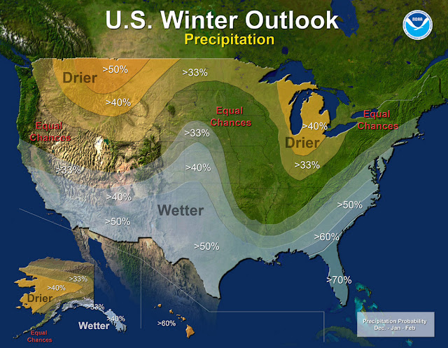
The 2016 U.S. Winter Outlook (December through February):

Winter 2016 - 2017 precipitation outlook. Click for larger view. (NOAA)
Winter 2016 – 2017 precipitation outlook. Click for larger view. (NOAA)

Precipitation

  • Wetter than normal conditions are most likely in the northern Rockies, around the Great Lakes, in Hawaii and in western Alaska
  • Drier than normal conditions are most likely across the entire southern U.S. and southern Alaska.

Temperature

  • Warmer than normal conditions are most likely across the southern U.S., extending northward through the central Rockies, in Hawaii, in western and northern Alaska and in northern New England.
  • Cooler conditions are most likely across the northern tier from Montana to western Michigan.
  • The rest of the country falls into the “equal chance” category, meaning that there is not a strong enough climate signal in these areas to shift the odds, so they have an equal chance for above-, near-, or below-normal temperatures and/or precipitation.

Drought

  • Drought will likely persist through the winter in many regions currently experiencing drought, including much of California and the Southwest
  • Drought is expected to persist and spread in the southeastern U.S. and develop in the southern Plains.
  • New England will see a mixed bag, with improvement in the western parts and persistence to the east.  
  • Drought improvement is anticipated in northern California, the northern Rockies, the northern Plains and parts of the Ohio Valley.

This seasonal outlook does not project where and when snowstorms may hit or provide total seasonal snowfall accumulations. Snow forecasts are dependent upon the strength and track of winter storms, which are generally not predictable more than a week in advance.  However, La Nina winters tend to favor above average snowfall around the Great Lakes and in the northern Rockies and below average snowfall in the mid-Atlantic.

NOAA produces seasonal outlooks to help communities prepare for what’s likely to come in the next few months and minimize weather’s impacts on lives and livelihoods. Empowering people with actionable forecasts and winter weather tips is key to NOAA’s effort to build aWeather-Ready Nation.

NOAA Winter Outlook: Little clarity as to El Niño’s impact on Thornton

Temperature - U.S. Winter Outlook: 2015-2016.  Click for larger view. (NOAA)
Temperature – U.S. Winter Outlook: 2015-2016. Click for larger view. (NOAA)

NOAA’s Climate Prediction Center released their 2015-2016 winter outlook this morning and while a strong El Niño will play a factor in some parts of the nation, its effects here are less clear.

As we have written about before, Colorado’s geographical location well inland, shelters it some from the effects of warm, Pacific waters.   Overall snowfall in Colorado during El Niño years has not trended greatly one way or another.  We have however seen some of our largest storms during El Niño.

NOAA’s outlook shows a pretty typical El Niño situation with some locations of the nation expected to receive copious amounts of moisture.  For us, it does point to a bit better chance of a wetter than normal period from December to February.

Read the complete text of NOAA’s outlook below.  At the bottom is the video they released to accompany it.

From NOAA:

Precipitation - U.S. Winter Outlook: 2015-2016. Click for larger view. (NOAA)
Precipitation – U.S. Winter Outlook: 2015-2016. Click for larger view. (NOAA)

Forecasters at NOAA’s Climate Prediction Center issued the U.S. Winter Outlook today favoring cooler and wetter weather in Southern Tier states with above-average temperatures most likely in the West and across the Northern Tier. This year’s El Niño, among the strongest on record, is expected to influence weather and climate patterns this winter by impacting the position of the Pacific jet stream.

“A strong El Niño is in place and should exert a strong influence over our weather this winter,” said Mike Halpert, deputy director, NOAA’s Climate Prediction Center. “While temperature and precipitation impacts associated with El Niño are favored, El Niño is not the only player. Cold-air outbreaks and snow storms will likely occur at times this winter. However, the frequency, number and intensity of these events cannot be predicted on a seasonal timescale.”

Other factors that often play a role in the winter weather include the Arctic Oscillation, which influences the number of arctic air masses that penetrate into the South and nor’easters on the East Coast, and the Madden-Julian Oscillation, which can impact the number of heavy rain storms in the Pacific Northwest.

The 2015 U.S. Winter Outlook (December through February):

Precipitation Outlook:

  • Wetter-than-average conditions most likely in the Southern Tier of the United States, from central and southern California, across Texas, to Florida, and up the East Coast to southern New England. Above-average precipitation is also favored in southeastern Alaska.
  • Drier-than-average conditions most likely for Hawaii, central and western Alaska, parts of the Pacific Northwest and northern Rockies, and for areas near the Great Lakes and Ohio Valley.

Temperature Outlook:

  • Above-average temperatures are favored across much of the West and the northern half of the contiguous United States. Temperatures are also favored to be above-average in Alaska and much of Hawaii. Below-average temperatures are most likely in the southern Plains and Southeast.

Drought Outlook:

  • The U.S. Drought Outlook shows some improvement is likely in central and southern California by the end of January, but not drought removal. Additional statewide relief is possible during February and March. Drought removal is likely across large parts of the Southwest, while improvement or removal is also likely in the southern Plains. However, drought is likely to persist in the Pacific Northwest and northern Rockies, with drought development likely in Hawaii, parts of the northern Plains and in the northern Great Lakes region.

While it is good news that drought improvement is predicted for California, one season of above-average rain and snow is unlikely to remove four years of drought,” said Halpert. “California would need close to twice its normal rainfall to get out of drought and that’s unlikely.”

This seasonal outlook does not project where and when snowstorms may hit or provide total seasonal snowfall accumulations. Snow forecasts are dependent upon the strength and track of winter storms, which are generally not predictable more than a week in advance.

NOAA produces seasonal outlooks to help communities prepare for what’s likely to come in the next few months and minimize weather’s impacts on lives and livelihoods. Empowering people with actionable forecasts and winter weather tips is key to NOAA’s effort to build a Weather-Ready Nation.

NOAA’s mission is to understand and predict changes in the Earth’s environment, from the depths of the ocean to the surface of the sun, and to conserve and manage our coastal and marine resources. Join us on Facebook, Twitter, Instagram and our other social media channels.