Late winter in Colorado can bring a wide variety of conditions, oftentimes within a very short time span. This was fully evident yesterday and last night as we went from a high of a daytime 62 degrees to receiving a healthy dose of snow before midnight.
Thornton received a total of 2.9 inches of heavy, wet snow from about 9:00 p.m. on March 4 through 1:00 a.m. on March 5. A healthy 0.45 inches liquid precipitation was recorded from the snow.
The time lapse video below captures the event from its start through sunrise. Below that is a satellite imagery time lapse from 7:00 a.m. to noon to show just how fast that snow disappeared.
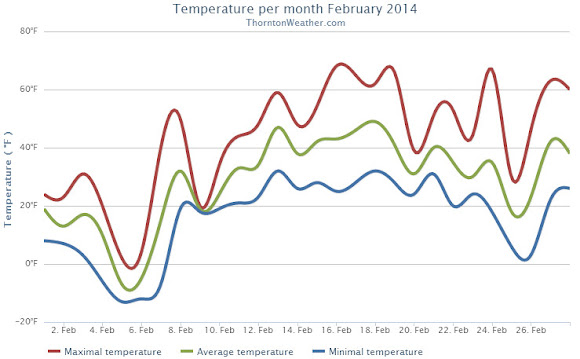
Like all months in Colorado, February 2014 did have some warm periods but those were few and far between as compared to the cold we experienced. Those cold temperatures did not translate to precipitation however.
The month started out quite cold with 9 out of the first 10 days seeing below normal temperatures. Two of those days saw ‘high’ temperatures only in the single digits. Seven of those 10 days stayed below freezing and four saw low temperatures below zero.
Warmer weather courtesy of downslope flow did finally arrive and most of the rest of the month was warmer than average. Of the last 18 days of the month, only two had below normal temperatures.
Overall Thornton’s monthly average temperature for February 2014 was 28.5 degrees. This was four degrees below Denver’s February average of 32.5 degrees. Officially Denver’s average for the month was close to ours at 28.2 degrees.
While clearly a cold month, February 2014 failed to reach ‘top 10 coldest February’ status. Number 10 on that list is February 1905 with an average temperature of 25.2 degrees. The coldest February was in 1899 with an average of 17.6 degrees.
Temperatures ranged from a high of 68.3 degrees on the 16th down to a low of -12.6 degrees on the morning of the 5th. Out at the airport, Denver saw its highest temperature of 68 degrees and its lowest of -19 degrees on the same dates.
Denver record low maximum temperatures on the 5th and 6th. High temperatures on those days were minus 1 degree and plus 1 degree respectively.
Thornton recorded a mere 0.17 inches of precipitation in the rain bucket during the month. Denver officially saw 0.19 inches. Both fall well short of the February average of 0.37 inches. While dry, it wasn’t dry enough to be one of the top 10 driest Februarys.
In terms of snowfall, Thornton measured 4.7 inches. Denver lagged with only 3.3 inches. Again, both were a good ways below the historical Denver average of 5.7 inches.
Thornton, Colorado February 2014 temperature summary. (ThorntonWeather.com)Add a Caption Thornton, Colorado February 2014 temperature summary. (ThorntonWeather.com)Thornton, Colorado February 2014 precipitation summary. (ThorntonWeather.com)
CLIMATE REPORT
NATIONAL WEATHER SERVICE BOULDER, CO
628 AM MST SAT MAR 1 2014

...................................

...THE DENVER CO CLIMATE SUMMARY FOR THE MONTH OF FEBRUARY 2014...

CLIMATE NORMAL PERIOD 1981 TO 2010
CLIMATE RECORD PERIOD 1872 TO 2014

WEATHER         OBSERVED          NORMAL  DEPART  LAST YEAR`S
                 VALUE   DATE(S)  VALUE   FROM    VALUE  DATE(S)
                                          NORMAL
................................................................
TEMPERATURE (F)
RECORD
 HIGH              77   02/28/2006
                        02/04/1890
 LOW              -25   02/01/1951
                        02/08/1936
HIGHEST            68   02/16        77      -9       63  02/17
LOWEST            -19   02/05       -25       6        5  02/22
AVG. MAXIMUM     42.3              46.2    -3.9     43.3
AVG. MINIMUM     14.1              18.9    -4.8     16.9
MEAN             28.2              32.5    -4.3     30.1
DAYS MAX >= 90      0               0.0     0.0        0
DAYS MAX <= 32      8               3.9     4.1        6
DAYS MIN <= 32     26              26.9    -0.9       28
DAYS MIN <= 0       5               1.3     3.7        0

PRECIPITATION (INCHES)
RECORD
 MAXIMUM         2.01   1934
 MINIMUM         0.01   1970
TOTALS           0.19              0.37   -0.18     0.77
DAILY AVG.       0.01              0.01    0.00     0.03
DAYS >= .01         4               5.3    -1.3        6
DAYS >= .10         1               0.7     0.3        4
DAYS >= .50         0               0.0     0.0        0
DAYS >= 1.00        0               0.0     0.0        0
GREATEST
 24 HR. TOTAL    0.12   02/04 TO 02/04              0.43
                                                 02/24 TO 02/24
 STORM TOTAL      2.3                                9.1
 (MM/DD(HH))            02/04 TO 02/04           02/24 TO 02/24

 SNOWFALL (INCHES)
RECORDS
 TOTAL           22.1   02-1912
 TOTAL            3.3   02-2014     5.7 1980-2010

DEGREE_DAYS
HEATING TOTAL    1022               908     114      972
 SINCE 7/1       4519              4439      80     4272
COOLING TOTAL       0                 0       0        0
 SINCE 1/1          0                 0       0        0

FREEZE DATES
RECORD
 EARLIEST     09/08/1962
 LATEST       06/08/2007
EARLIEST                        10/07
LATEST                          05/05
.....................................................

WIND (MPH)
AVERAGE WIND SPEED              10.5
RESULTANT WIND SPEED/DIRECTION   2/270
HIGHEST WIND SPEED/DIRECTION    48/270    DATE  02/16
HIGHEST GUST SPEED/DIRECTION    59/270    DATE  02/16

SKY COVER
POSSIBLE SUNSHINE (PERCENT)   MM
AVERAGE SKY COVER           0.60
NUMBER OF DAYS FAIR            2
NUMBER OF DAYS PC             18
NUMBER OF DAYS CLOUDY          8

AVERAGE RH (PERCENT)     63

WEATHER CONDITIONS. NUMBER OF DAYS WITH
THUNDERSTORM              0     MIXED PRECIP               0
HEAVY RAIN                0     RAIN                       0
LIGHT RAIN                1     FREEZING RAIN              0
LT FREEZING RAIN          0     HAIL                       0
HEAVY SNOW                0     SNOW                       1
LIGHT SNOW               10     SLEET                      0
FOG                      19     FOG W/VIS <= 1/4 MILE      8
HAZE                     12

-  INDICATES NEGATIVE NUMBERS.
R  INDICATES RECORD WAS SET OR TIED.
MM INDICATES DATA IS MISSING.
T  INDICATES TRACE AMOUNT.
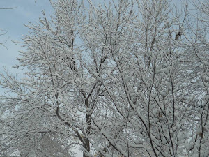
February started with a shot of snow in Thornton. (Jason McNeil)
The month of February is one that begins a transition to warmer temperatures and oftentimes lacks snowfall. Nevertheless, Mother Nature oftentimes offers stunning scenes to be captured in imagery as we see in our February 2014 slideshow.
Slideshow updated February 28, 2014
Showcasing images captured by ThorntonWeather.com readers as well as some of our own, our monthly slideshow covers the entire gamut of weather-related imagery. Sunsets, sunrises, wildlife and of course snow are vividly depicted.
Throughout the month we will gather the images sent to us via email or shared with us via our various social media outlets and post them in the slideshow below.
One of our friends was hanging out along the South Platte again this afternoon. Had to shoot pictures into the sun but with the iridescent clouds in the background it looks really cool.
Cloud iridescence is caused by clouds (usually cirrus) that have small water droplets or ice crystals in them causing the light to be diffracted, or spread out. The phenomena is much like the rainbow colors seen with oil in water.
Remember we are always looking for pics of just about anything to add to our monthly slideshow. Be sure to email or post them so we can add them. Check out this month’s slideshow here.
A bald eagles rests in a tree along the South Platte River. (ThorntonWeather.com)
The big chill continued on Thursday as for the second day in a row the Mile High City’s high temperature set a record as the coldest for the date.
As officially measured at DIA, Denver’s high temperature today was 1 degree. That easily bested the previous record low maximum for February 6 of 5 degrees set in 1929 and years prior.
Here in Thornton we fared slightly better with our high temperature topping out at 4 degrees today and 1.9 degrees on Wednesday.
Warmer weather is on the way as the cold Arctic air mass is expected to be pushed out tomorrow. Temperatures on Friday should climb above freezing for the first time in eight days.
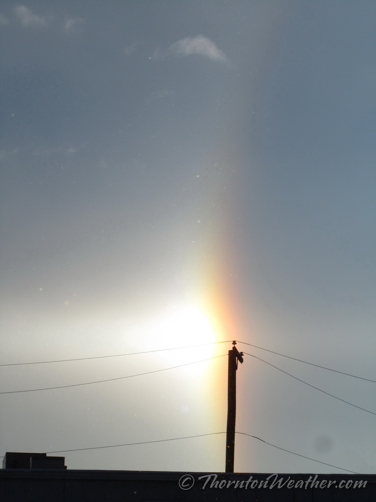
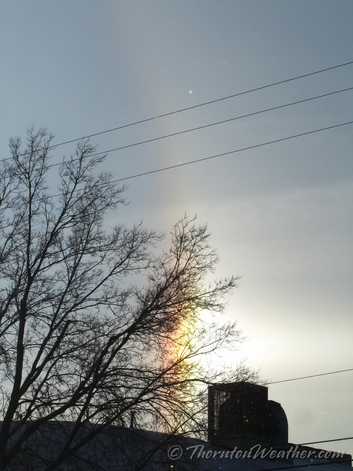
If you happened to look to the east at about 7:45 a.m. this morning you were treated to something pretty cool – a sun dog.
A sun dog is also called a ‘mock sun’, ‘phantom sun’ or ‘parhelia.’ These appear as bright spots to either side of the sun at the same distance above the horizon. They are caused by sunlight refracting through hexagonal ice crystals, usually in cirrus clouds. As the light hits the crystals, it is bent 22 degrees before reaching your eyes, thus creating the phenomena.
We took these images in north Denver.
February 5, 2014 – The full, bright sun dog. (ThorntonWeather.com)February 5, 2014 – The north ‘mock sun.’ (ThorntonWeather.com)February 5, 2014 – The south ‘mock sun.’ (ThorntonWeather.com)
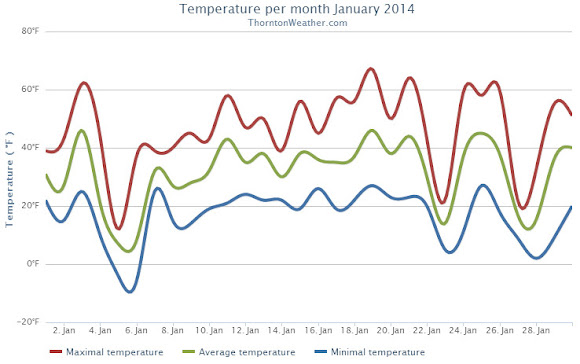
January 2014 could be remembered as a month that brought a weather rollercoaster. Looking back it seems as if we were constantly jumping between mild temperatures to cold to warmth and back to cold again.
The month started out cooler than normal for the first two days with a light shot of snow on New Year’s Day. Temperatures then shot into the 60s on the 3rd but were followed by colder temperatures and more snow on the 4th. On the 5th we registered our coldest day of the month.
From the 7th to the 16th we experienced relatively calm conditions and only very light snow on one day. We saw above normal temperatures from the 15th to the 21st. Two cold days followed with snow falling on the 23rd.
Alternating above-normal and below-normal temperatures closed out the month. Four of the last five days saw snowfall.
Thornton recorded an average monthly temperature of 31.3 degrees. This was slightly higher than Denver’s official recording of 31.2 degrees. Both were slightly above the historical average January temperature of 30.7 degrees.
Temperatures in Thornton ranged from a high of 67.0 degrees on the 19th down to a low of -5.5 degrees on the 6th. Denver’s warmest temperature of 65 degrees also occurred on the 19th and it recorded its coldest of -10 degrees on the 5th.
All 31 days of the month saw low temperatures below freezing in Thornton and four days saw high temperatures fail to reach 32 degrees. Two days saw readings below zero. Denver’s readings were similar with four days staying below freezing and three seeing lows below zero.
Precipitation for the month was nearly double of the Denver historical average thanks to snowfall that was about double of normal.
Thornton recorded 1.06 inch of liquid precipitation, well above the average of 0.41 inch. Denver saw a bit less with 0.94 inch.
While no major snowstorms were seen, there were plenty of smaller events. These gave Thornton 13.4 inches of the white stuff during the month, Denver saw 14.3 inches. Both were about double the January average of 7.1 inches. The official Denver measurement propelled January 2014 into the books as the 11th snowiest January on record.
Thornton, Colorado January 2014 temperature summary.Thornton, Colorado January 2014 precipitation summary.
CLIMATE REPORT
NATIONAL WEATHER SERVICE BOULDER, CO
517 AM MST SAT FEB 1 2014

...................................

...THE DENVER CO CLIMATE SUMMARY FOR THE MONTH OF JANUARY 2014...

CLIMATE NORMAL PERIOD 1981 TO 2010
CLIMATE RECORD PERIOD 1872 TO 2014

WEATHER         OBSERVED          NORMAL  DEPART  LAST YEAR`S
                 VALUE   DATE(S)  VALUE   FROM    VALUE  DATE(S)
                                          NORMAL
................................................................
TEMPERATURE (F)
RECORD
 HIGH              76   01/27/1888
 LOW              -29   01/09/1875
HIGHEST            65   01/19        76     -11       66  01/24
LOWEST            -10   01/05       -29      19      -12  01/12
AVG. MAXIMUM     44.9              44.0     0.9     44.6
AVG. MINIMUM     17.3              17.4    -0.1     16.0
MEAN             31.1              30.7     0.4     30.3
DAYS MAX >= 90      0               0.0     0.0        0
DAYS MAX <= 32      4               5.5    -1.5        6
DAYS MIN <= 32     30              29.4     0.6       30
DAYS MIN <= 0       3               1.7     1.3        5

PRECIPITATION (INCHES)
RECORD
 MAXIMUM         2.35   1883
 MINIMUM         0.01   1933
                        1934
                        1952
TOTALS           0.94              0.41    0.53     0.31
DAILY AVG.       0.03              0.01    0.02     0.01
DAYS >= .01         9               4.1     4.9        4
DAYS >= .10         3               0.9     2.1        1
DAYS >= .50         0               0.0     0.0        0
DAYS >= 1.00        0               0.0     0.0        0
GREATEST
 24 HR. TOTAL    0.26   01/30 TO 01/31           01/28 TO 01/29
                                                          01/29 TO 01/29
                                                          01/29 TO 01/29
 STORM TOTAL       MM                                 MM
 (MM/DD(HH))            MM                    01/29(00) TO 01/29(00)
                                                 01/29(00) TO 01/29(00)9
                                                 01/29(00) TO 01/29(00)9

SNOWFALL (INCHES)
RECORDS
 TOTAL             MM   MM
TOTALS           14.3               7.0

DEGREE_DAYS
HEATING TOTAL    1046              1063     -17     1067
 SINCE 7/1       3497              3531     -34     3300
COOLING TOTAL       0                 0       0        0
 SINCE 1/1          0                 0       0        0

FREEZE DATES
RECORD
 EARLIEST     09/08/1962
 LATEST       06/08/2007
EARLIEST                        10/07
LATEST                          05/05
..........................................................

WIND (MPH)
AVERAGE WIND SPEED              10.7
RESULTANT WIND SPEED/DIRECTION   4/230
HIGHEST WIND SPEED/DIRECTION    36/290    DATE  01/12
HIGHEST GUST SPEED/DIRECTION    44/280    DATE  01/12

SKY COVER
POSSIBLE SUNSHINE (PERCENT)   MM
AVERAGE SKY COVER           0.50
NUMBER OF DAYS FAIR           10
NUMBER OF DAYS PC             14
NUMBER OF DAYS CLOUDY          7

AVERAGE RH (PERCENT)     56

WEATHER CONDITIONS. NUMBER OF DAYS WITH
THUNDERSTORM              0     MIXED PRECIP               0
HEAVY RAIN                0     RAIN                       0
LIGHT RAIN                0     FREEZING RAIN              0
LT FREEZING RAIN          0     HAIL                       0
HEAVY SNOW                2     SNOW                       5
LIGHT SNOW               11     SLEET                      0
FOG                      11     FOG W/VIS <= 1/4 MILE      4
HAZE                      4

-  INDICATES NEGATIVE NUMBERS.
R  INDICATES RECORD WAS SET OR TIED.
MM INDICATES DATA IS MISSING.
T  INDICATES TRACE AMOUNT.
February in Colorado typically brings to an end an extended period when average temperatures are at their lowest. Winter begins to loosen its grip and temperatures get warmer but precipitation is not a particularly common event during the month.
Thanks to some late January snows, Denver’s seasonal snowfall has started to rebound but still remains below normal. February is only our sixth snowiest month so it may not provide much help on the precipitation month.
Temperatures however do usually see a nice rebound during the month. Average high temperatures climb from an average of 44 degrees at the start to 50 degrees by the end of February.
January 3, 2014 – Stunning wave cloud sunset as seen from Brighton. View more images in the slideshow below. (Brandi Donahue)
While typically a cold month, January is oftentimes lacking in terms of weather drama. Living in Colorado however provides plenty of opportunity to capture a wide variety of weather-related imagery as we see in our January 2014 slideshow.
Slideshow updated January 31, 2014
In this, our first monthly photo slideshow, we feature photos that not only we have taken but also those taken by ThorntonWeather.com fans.
Throughout the month we will gather the images sent to us via email or shared with us via our various social media outlets and post them in the slideshow below.
With us only being one week into the month, great photos of sunsets, wildlife, pets and wintry conditions have emerged. We love them all!
Thanks to a snowy start and a similarly snowy finish, the month of January 2014 climbed onto the list of top 10 January snow measurements in the Mile High City.
Officially the month ended with 14.3 inches of snowfall as measured at Denver International Airport. It was just enough to bump January 1991 from the number 10 spot (14.1 inches).
Here in Thornton we received just a bit less as we saw 13.4 inches of the white stuff.
January is only our fourth snowiest month with an average of 7.0 inches (based on 1981 to 2010 normals). The snowiest January on record occurred in 1992 when 24.3 inches of snow fell.
Looking at the 2013 / 2014 snow season, January helped make up some lost ground from the previous dry months.
The seasonal total now stands at 22.4 inches, 5.4 inches below the long term average of 27.8 inches we normally receive by the end of January. Thornton’s seasonal total is a bit better but still below normal at 24.2 inches.


 The big chill continued on Thursday as for the second day in a row the Mile High City’s high temperature set a record as the coldest for the date.

 February in Colorado typically brings to an end an extended period when average temperatures are at their lowest. Winter begins to loosen its grip and temperatures get warmer but precipitation is not a particularly common event during the month.
 Thanks to a snowy start and a similarly snowy finish, the month of January 2014 climbed onto the list of top 10 January snow measurements in the Mile High City.