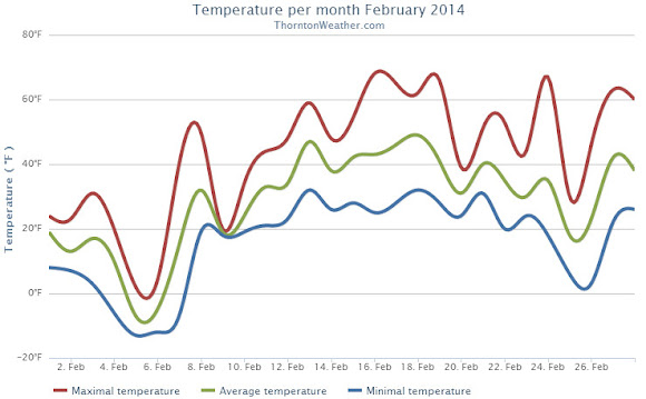
Like all months in Colorado, February 2014 did have some warm periods but those were few and far between as compared to the cold we experienced. Those cold temperatures did not translate to precipitation however.
The month started out quite cold with 9 out of the first 10 days seeing below normal temperatures. Two of those days saw ‘high’ temperatures only in the single digits. Seven of those 10 days stayed below freezing and four saw low temperatures below zero.
Warmer weather courtesy of downslope flow did finally arrive and most of the rest of the month was warmer than average. Of the last 18 days of the month, only two had below normal temperatures.
Overall Thornton’s monthly average temperature for February 2014 was 28.5 degrees. This was four degrees below Denver’s February average of 32.5 degrees. Officially Denver’s average for the month was close to ours at 28.2 degrees.
While clearly a cold month, February 2014 failed to reach ‘top 10 coldest February’ status. Number 10 on that list is February 1905 with an average temperature of 25.2 degrees. The coldest February was in 1899 with an average of 17.6 degrees.
Temperatures ranged from a high of 68.3 degrees on the 16th down to a low of -12.6 degrees on the morning of the 5th. Out at the airport, Denver saw its highest temperature of 68 degrees and its lowest of -19 degrees on the same dates.
Denver record low maximum temperatures on the 5th and 6th. High temperatures on those days were minus 1 degree and plus 1 degree respectively.
Thornton recorded a mere 0.17 inches of precipitation in the rain bucket during the month. Denver officially saw 0.19 inches. Both fall well short of the February average of 0.37 inches. While dry, it wasn’t dry enough to be one of the top 10 driest Februarys.
In terms of snowfall, Thornton measured 4.7 inches. Denver lagged with only 3.3 inches. Again, both were a good ways below the historical Denver average of 5.7 inches.
Click here to view Thornton’s February 2014 climate report.

CLIMATE REPORT
NATIONAL WEATHER SERVICE BOULDER, CO
628 AM MST SAT MAR 1 2014

...................................

...THE DENVER CO CLIMATE SUMMARY FOR THE MONTH OF FEBRUARY 2014...

CLIMATE NORMAL PERIOD 1981 TO 2010
CLIMATE RECORD PERIOD 1872 TO 2014

WEATHER         OBSERVED          NORMAL  DEPART  LAST YEAR`S
                 VALUE   DATE(S)  VALUE   FROM    VALUE  DATE(S)
                                          NORMAL
................................................................
TEMPERATURE (F)
RECORD
 HIGH              77   02/28/2006
                        02/04/1890
 LOW              -25   02/01/1951
                        02/08/1936
HIGHEST            68   02/16        77      -9       63  02/17
LOWEST            -19   02/05       -25       6        5  02/22
AVG. MAXIMUM     42.3              46.2    -3.9     43.3
AVG. MINIMUM     14.1              18.9    -4.8     16.9
MEAN             28.2              32.5    -4.3     30.1
DAYS MAX >= 90      0               0.0     0.0        0
DAYS MAX <= 32      8               3.9     4.1        6
DAYS MIN <= 32     26              26.9    -0.9       28
DAYS MIN <= 0       5               1.3     3.7        0

PRECIPITATION (INCHES)
RECORD
 MAXIMUM         2.01   1934
 MINIMUM         0.01   1970
TOTALS           0.19              0.37   -0.18     0.77
DAILY AVG.       0.01              0.01    0.00     0.03
DAYS >= .01         4               5.3    -1.3        6
DAYS >= .10         1               0.7     0.3        4
DAYS >= .50         0               0.0     0.0        0
DAYS >= 1.00        0               0.0     0.0        0
GREATEST
 24 HR. TOTAL    0.12   02/04 TO 02/04              0.43
                                                 02/24 TO 02/24
 STORM TOTAL      2.3                                9.1
 (MM/DD(HH))            02/04 TO 02/04           02/24 TO 02/24

 SNOWFALL (INCHES)
RECORDS
 TOTAL           22.1   02-1912
 TOTAL            3.3   02-2014     5.7 1980-2010

DEGREE_DAYS
HEATING TOTAL    1022               908     114      972
 SINCE 7/1       4519              4439      80     4272
COOLING TOTAL       0                 0       0        0
 SINCE 1/1          0                 0       0        0

FREEZE DATES
RECORD
 EARLIEST     09/08/1962
 LATEST       06/08/2007
EARLIEST                        10/07
LATEST                          05/05
.....................................................

WIND (MPH)
AVERAGE WIND SPEED              10.5
RESULTANT WIND SPEED/DIRECTION   2/270
HIGHEST WIND SPEED/DIRECTION    48/270    DATE  02/16
HIGHEST GUST SPEED/DIRECTION    59/270    DATE  02/16

SKY COVER
POSSIBLE SUNSHINE (PERCENT)   MM
AVERAGE SKY COVER           0.60
NUMBER OF DAYS FAIR            2
NUMBER OF DAYS PC             18
NUMBER OF DAYS CLOUDY          8

AVERAGE RH (PERCENT)     63

WEATHER CONDITIONS. NUMBER OF DAYS WITH
THUNDERSTORM              0     MIXED PRECIP               0
HEAVY RAIN                0     RAIN                       0
LIGHT RAIN                1     FREEZING RAIN              0
LT FREEZING RAIN          0     HAIL                       0
HEAVY SNOW                0     SNOW                       1
LIGHT SNOW               10     SLEET                      0
FOG                      19     FOG W/VIS <= 1/4 MILE      8
HAZE                     12

-  INDICATES NEGATIVE NUMBERS.
R  INDICATES RECORD WAS SET OR TIED.
MM INDICATES DATA IS MISSING.
T  INDICATES TRACE AMOUNT.