|
MIAMI — As the of peak the hurricane season approaches, forecasters predicted with confidence on Thursday that storm activity would remain low this year. “We have an even higher confidence that this year’s hurricane season will be below normal,” said Gerry Bell, the lead seasonal hurricane forecaster at the National Oceanic and Atmospheric Administration’s Climate Prediction… Continue reading Hurricane season is predicted to remain below average |
Category Archives: National Weather
State of the Climate 2014: Warmer, wetter than normal in the U.S.
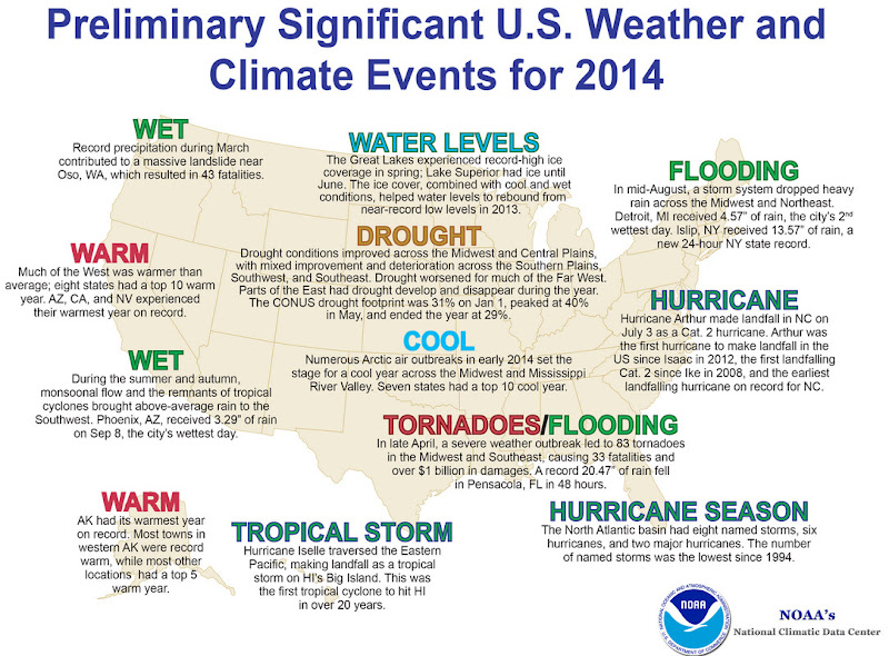
The National Climatic Data Center (NCDC) has released its summary of the nation’s climate and weather for 2014. Its analysis shows that overall, the United States experienced warmer than normal temperatures and above average precipitation.
From NOAA / NCDC:
2014 U.S. temperature exceeds 20th-century average for the 18th consecutive year
Second warmest December boosted 2014 to 34th warmest year for contiguous U.S; eight weather and climate disasters exceeded $1 billion in damages
The 2014 annual average contiguous U.S. temperature was 52.6°F, 0.5°F above the 20th century average. Very warm conditions dominated the West, with four states having their warmest year on record, while the Midwest and Mississippi Valley were cool. This ranked as the 34th warmest year since we began keeping track in the 1895, while the temperature exceeded the 20th Century average for the 18th consecutive year.
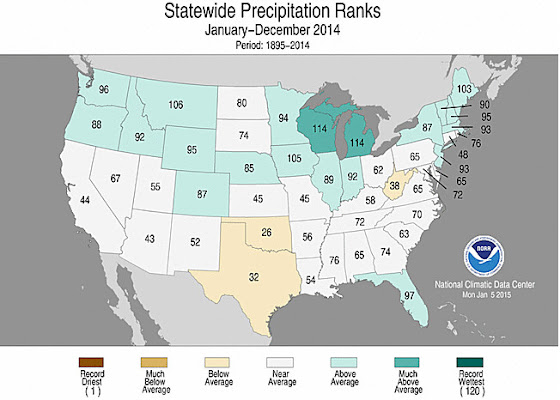
The average contiguous U.S. precipitation was 30.76 inches, 0.82 inch above average, and ranked as the 40th wettest year in the 120-year period of record. The Northern U.S. was wet, and the Southern Plains were dry; the national drought footprint shrank about 2 percent.
In 2014, there were eight weather/climate disaster events with losses exceeding $1 billion each across the United States. These eight events resulted in the deaths of 53 people. The events include: the western U.S. drought, the Michigan & Northeast flooding event, five severe storm events, and one winter storm event.
U.S. climate highlights: 2014
- The West was warmer than average for much of 2014. Nine states had a top 10 warm year.Alaska, Arizona, California, and Nevada each had their warmest year on record. Most locations from the Rockies to the East Coast were cooler than average, with the exception of New England and Florida. Seven states across the Midwest and Mississippi River Valley had a top 10 cool year. No state was record cold during 2014.
- The Pacific Northwest, Northern Rockies, Midwest, and Northeast were all wetter than average. Michigan and Wisconsin each had their seventh wettest year on record. The Southern Plains and parts of the Ohio Valley were drier than average, but no state was top 10 dry. The rest of the contiguous U.S. had near-average annual precipitation totals.
- The U.S. Climate Extremes Index (USCEI) for 2014 was 35 percent above average, ranking as the 19th highest annual USCEI in the 105-year record. The components of the USCEI that were much above average for the year included warm nighttime temperatures and 1-day precipitation totals. The USCEI is an index that tracks extremes (falling in the upper or lower 10 percent of the record) in temperature, precipitation, drought, and land-falling tropical cyclones across the contiguous U.S.

Holiday shopping for weather enthusiasts made easy at Weather Geek Stuff

Not everyone gets excited about blizzards, tornadoes, hurricanes and other types of extreme weather but many folks out there are passionate about Mother Nature. Weather Geek Stuff is an online shop just for those whose hearts race with the thrill of severe weather and they are offering special deals through the holiday season.
Weather Geek Stuff is an online store that provides a host of clothing items and novelties just for weather buffs. From the store’s custom ‘Weather Geek’ and ‘Weather Diva’ logoed merchandise to items imprinted with amusing weather warnings signs as well as Skywarn storm spotter logos, there is something there sure to please any weather lover.
Weather Geek Stuff’s merchandise was shown on the Weather Channel as a recommended gift so you know the quality is good. Stu Ostro, Weather Channel’s Senior Director of Weather Communications even sports a ‘Weather Geek’ t-shirt on his Facebook page and Twitter profile.
Kids and dogs aren’t left out of the weather fun either. There is a wide variety of clothing items sized just right for the little ones from babies to bigger kids. Canine companions as well can get shirts and bowls emblazoned with a weather-related logo.
The selection goes far beyond clothing too. Water bottles, clocks, mugs, bags and other novelties are part of the store’s offerings. For the tech types, cases for iPhones and iPads are available. Recently added products include laptop skins, clipboards and throw blankets.
Support ThorntonWeather .com
Weather Geek Stuff is owned and operated by the same folks that run ThorntonWeather.com. We provide ThorntonWeather.com as a no-cost service to the community and use the minimal amount of money made from Weather Geek Stuff to support the costs of running this website and the associated equipment. So remember, if you have a weather buff on your shopping list, by buying from Weather Geek Stuff you are supporting ThorntonWeather.com! You can also donate directly to fund the site here.

Video captures twin EF-4 tornadoes in Nebraska

Severe weather struck eastern Nebraska on June 16 spawning an amazing four EF-4 rated tornadoes in less than an hour. Two of these were twins, formed from the same supercell thunderstorm at nearly the same time, and stunning video from a resident’s porch shows the beasts.
While this event and the video are a few weeks old, it is well worth sharing. The imagery is a stunning display of Mother Nature’s most violent phenomena.
Timothy Klaustermeier took the video and posted it to YouTube. The nearly seven minute long video shows both tornadoes that spawned near Pilger and lifted north of Wisner. Amazingly the man appears to have been quite calm during the event as the only sounds heard are the roaring of the twisters.
The National Weather Service rated both of these tornadoes as EF4s on the Enhanced Fujita Scale which means they were packing winds of at least 166mph. One traveled over 18 miles, the other nearly 12 miles.
Two other twisters in the same area, one just before and one just after the twins, were also rated EF4s.
Extensive damage was seen in the areas of Pilger and Wisner. Two fatalities were recorded: A five year old girl and a 75 year old man. Sixteen people were critically injured in the storms.
San Diego wildfire prompts evacuation orders for 20,000 homes
|
|
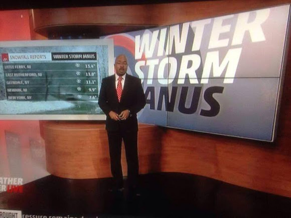
Yet another reason the Weather Channel shouldn’t name winter storms
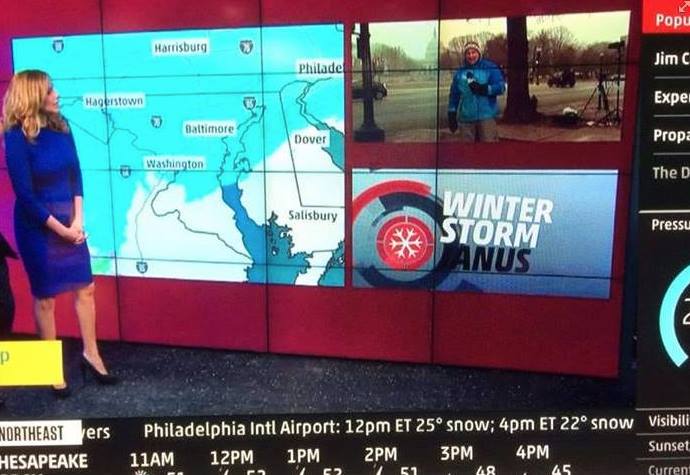
Last year the Weather Channel unilaterally decided to start naming winter storms, a decision met with ridicule and concern from weather professionals. Now, with a storm TWC calls ‘Janus’, we very graphically can see another reason why the naming of these storms may not be a good idea.
The list the Weather Channel created for winter storms during the 2013 – 2014 season range contains everything from Latin words and Roman governors to mythological figures.
The channel is calling the current storm pounding the Northeast ‘Janus.’ Janus comes from Roman mythology and was considered the god of beginnings and transitions.
Setting aside the fact the naming of winter storms is ridiculous and only serves to confuse people in potentially dangerous situation, the display of the name during broadcasts has brought further ridicule.
Many graphics showing the word ‘Janus’ on TWC were partially obscured by their on air personalities and even their own imagery. The end result has been the appearance of the name without the ‘J’.
See the screenshot top right and below.
Related stories from Examiner.com:
- Weather Channel goes dark on DirecTV, other weather networks ready to jump in
- Weather Channel says manmade climate change a factor in dispute with DirecTV
- Weather Channel names first two winter storms, weather community mocks network
Historical Super Bowl temperatures, conditions and weather extremes

Super Bowl XLVIII will be the first NFL championship game played outdoors at a cold-weather location. Looking back at the history of previous sites for the event, much milder weather than what will likely be seen at MetLife Stadium in New Jersey this year has been the rule.
Over the past 47 Super Bowl’s, the average on-field temperature at kickoff has been 66.5 degrees. The contests that have been played at northern latitudes have previously been in domed stadiums helping to keep that average up. That is a luxury the Denver Broncos and Seattle Seahawks won’t enjoy.
It is highly likely that this year’s Super Bowl between the Denver Broncos and Seattle Seahawks will be the coldest on record and possibly the first to have snow fall on the field.
How would that compare to weather extremes experienced during other NFL championship games? Find out in the story on Examiner.com
Weather Geek Stuff offers wide array of gear for the weather enthusiast on your shopping list
Not everyone gets excited about blizzards, tornadoes, hurricanes and other types of extreme weather but many folks out there are passionate about Mother Nature. Weather Geek Stuff is an online shop just for those whose hearts race with the thrill of severe weather and they are offering special deals through the holiday season.
Weather Geek Stuff is an online store that provides a host of clothing items and novelties just for weather buffs. From the store’s custom ‘Weather Geek’ and ‘Weather Diva’ logoed merchandise to items imprinted with amusing weather warnings signs as well as Skywarn storm spotter logos, there is something there sure to please any weather lover.
Weather Geek Stuff’s merchandise was shown on the Weather Channel as a recommended gift so you know the quality is good. Stu Ostro, Weather Channel’s Senior Director of Weather Communications even sports a ‘Weather Geek’ t-shirt on his Facebook page and Twitter profile.
Kids and dogs aren’t left out of the weather fun either. There is a wide variety of clothing items sized just right for the little ones from babies to bigger kids. Canine companions as well can get shirts and bowls emblazoned with a weather-related logo.
The selection goes far beyond clothing too. Water bottles, clocks, mugs, bags and other novelties are part of the store’s offerings. For the tech types, cases for iPhones and iPads are available. New products this season include laptop skins, clipboards and throw blankets.
Support ThorntonWeather .com
Weather Geek Stuff is owned and operated by the same folks that run ThorntonWeather.com. We provide ThorntonWeather.com as a no-cost service to the community and use the minimal amount of money made from Weather Geek Stuff to support the costs of running this website and the associated equipment. So remember, if you have a weather buff on your shopping list, by buying from Weather Geek Stuff you are supporting ThorntonWeather.com! You can also donate directly to fund the site here.
Remembering 9/11: NASA imagery of fateful day serves as a reminder

Twelve years ago today the United States of America was forever changed when war was brought to our own shores for the first time since Pearl Harbor. The imagery of that day still burns vividly in our memories and one from NASA shows the devastation of that day as seen from 200 miles above.
On that fateful day, crewmembers of the Expedition Three crew of the International Space Station were circling the globe.
Commander Frank L. Culbertson, Soyuz Commander Vladimir Dezhurov and Flight Engineer Mikhail Tyurin surely felt helpless as they passed over Ground Zero and could clearly see the plume of smoke emanating from the spot where so many people lost their lives.
The image they captured on that day was stunning – see below. While the World Trade Center was so far below, the devastation was so clear.
Our patriotism pulled us through those trying times and it shouldn’t take another attack to galvanize us in solidarity.
Today let us stand together to remember the victims of that horrible day.
Let us stand together and pay tribute to the lives of the thousands of men and women that have carried the battle forth since then and paid the ultimate sacrifice.
Let us stand together and honor the hundreds of thousands who wear our nation’s uniforms protecting us.
Let us never forget so that we and our children will never experience another day like 9/11.
NEVER FORGET!

Internet resources for wildfire information and education

As wildfires burn across much on the western United States late this summer, the Internet can be a wealth of information for residents that are affected by these blazes or for anyone else. Resources are available for everything from the latest news updates, finding out where the fires are right down to the street level, to safety and education.
This list is by no means all inclusive – if you have a wildfire related link we are missing, please post a comment and let us know and we will update our list!
Updated 6/21/2013
- National Level Agencies
- Fire Mapping
- Weather
- Wildfire Imagery
- Wildfire Education & Information
- Wildfire Assistance
- State Agencies
- InciWeb – Incident Information
- National Interagency Coordination Center (NICC)
- National Interagency Fire Center (NIFC)
- Latest situation report (PDF) – Updated daily
- National Fire News – Updated daily
- Wildland Fire Statistics
- Historical Statistics
- National Park Service – Fire & Aviation Management
- U.S. Bureau of Land Management – Fire & Aviation
- U.S. Fish & Wildlife Service – Fire Management
- U.S. Forest Service (USFS) – Fire and Aviation Management
- USFS Geographic Coordination Centers
- USFS MODIS Active Fire Mapping Program
- NOAA Hazard Mapping System Fire and Smoke Product
- NOAA Satellite Fire Detections
- NOAA SSD Fire Detection Program – Fire and smoke maps
- USFS Active Fire Mapping Program
- USGS GeoMAC – Mapping
- USGS Active Fire Perimeter Map (Google Map)
- USGS Natural Hazards Support System
- National Weather Service
- NOAA Storm Prediction Center Fire Weather
- Rocky Mountain Area Coordination Center Outlooks
- MODIS Rapid Response System
- NASA Earth Observatory
- NOAA Environmental Visualization Laboratory (EVL)
- NOAA Satellite Services Division
Wildfire Education & Information
- Firewise – Information for homeowners and public policy makers about responsible planning
- Google search – Wildfire & forest fire education
- Google News search – Forest fires & wildfires
- Healthy Forests and Rangelands – Info about National Fire Plan (NFP), Healthy Forests Initiative (HFI), and related initiatives
- U.S. Fire Administration
- Smokey Bear
- USFS Fire Education
- Wildfire Today Blog
- Alabama Forestry Commission
- Alaska Division of Forestry
- Arkansas Forestry Commission
- California Department of Forestry & Fire Protection
- Colorado State Forest Service
- Connecticut Department of Environmental Protection
- Delaware Department of Agriculture
- Florida Division of Forestry
- Georgia Forestry Commission
- Hawaii Division of Forestry & Wildlife
- Idaho Department of Lands
- Illinois Divison of Forest Resources
- Indiana Division of Forestry
- Iowa DNR Forestry
- Kansas Forest Service
- Kansas Forest Service
- Kentucky Division of Forestry
- Louisiana Department of Agriculture & Forestry
- Maine Forest Service
- Maryland Forest Service
- Massachusetts Department of Conservation & Recreation – Forestry
- Minnesota Division of Forestry
- Mississippi Forestry Commission
- Missouri Department of Conservation – Forestry
- Montana DNRC Forestry Division
- Nebraska Forest Service
- Nebraska Forestry Service
- Nevada Division of Forestry
- New Hampshire Division of Forests and Lands
- New Mexico State Forestry
- New York Division of Environmental Conservation – Forests
- North Carolina Division of Forest Resources
- North Dakota Forest Service
- Ohio Division of Forestry
- Oklahoma Forestry Services
- Oregon Department of Forestry
- Pennsylvania Bureau of Forestry
- Rhode Island Division of Forest Environment
- South Carolina Forestry Commission
- South Dakota Resource Conservation & Forestry
- South Dakota Wildland Fire Suppression Division
- Tennessee Division of Forestry
- Texas Forest Service
- Utah Division of Forestry, Fire & State Lands
- Vermont Department of Forests, Parks & Recreation
- Virginia Department of Forestry
- Washington State Department of Natural Resources
- West Virginia Division of Forestry
- Wisconsin Division of Forestry
- Wyoming State Forestry Division