![]() An interesting article in the Denver Post today talks about how the forecasts for a dry winter have been way off the mark (thus far). Even as recently as a month ago NOAA was saying that La Nina was going to wreak havoc and dry things out severely. Yet today the mountains continue to have an amazing amount of snowpack with every basin well above normal.
An interesting article in the Denver Post today talks about how the forecasts for a dry winter have been way off the mark (thus far). Even as recently as a month ago NOAA was saying that La Nina was going to wreak havoc and dry things out severely. Yet today the mountains continue to have an amazing amount of snowpack with every basin well above normal.
Meteorologist Klaus Wolter told the Denver Post that recent failures of their predictions may be traced to climate change. Wolter said, “So we have two years in a row here where the atmosphere does not behave as we expect. Maybe global changes are pulling the rug out from underneath us. We may not know the answer for 10 years, . . . but one pet answer is that you should get more variability with global change.”
There it is! You knew it was coming! If all else fails, blame global warming! 🙂
In all seriousness, assuming things continue as they have been, the concern now shifts not from drought but to possible flooding this spring. Emergency planners are keeping a close eye and a fast run-off could not only lead to a loss of good, usable water but it could also cause a lot of problems.
Despite the mountains of snow in the mountains, here on the plains we haven’t been quite as fortunate. In the metro area, the historical seasonal average through the end of February is 39.6 inches of snow. As of this morning (2/14), thus far this season ThorntonWeather.com has recorded 33.0 nches and the National Weather Service puts the official Denver measurement at 35.5 inches. This puts us below average but there are still 15 days left in this month to catch up.
Please click here to view the entire Denver Post article: Dry winter forecasts miss mark.
 Recent snows along with high winds have raised the avalanche danger in the high country to “considerable” in many areas according to the
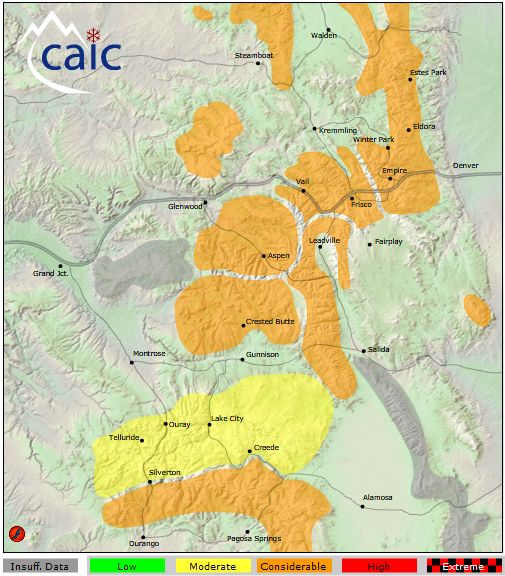