![]() Because of the delay, we can expect light snow showers throughout the day, possibly making for a messy commute home. Roads could be slick so be careful out there. The snow will continue till the evening and we can expect between one and three inches total accumulation.
Because of the delay, we can expect light snow showers throughout the day, possibly making for a messy commute home. Roads could be slick so be careful out there. The snow will continue till the evening and we can expect between one and three inches total accumulation.
Category Archives: Colorado Weather
More snow on the way this evening – the third storm in a week.
![]() Here it comes again but this time won’t be as bad as the last two. This storm should move pretty quickly through the area tonight and into tomorrow morning. Current indications are we can expect between 1 and 4 inches of the white stuff. A lot of folks are already tired of the snow but remember that while the mountains have had a ton of snow, here on the Front Range we are still a good ways below normal for precipitation!
Here it comes again but this time won’t be as bad as the last two. This storm should move pretty quickly through the area tonight and into tomorrow morning. Current indications are we can expect between 1 and 4 inches of the white stuff. A lot of folks are already tired of the snow but remember that while the mountains have had a ton of snow, here on the Front Range we are still a good ways below normal for precipitation!
Snow on Christmas?
![]() Unfortunately, historical trends don’t give us too good of a chance but there is always hope – remember last year? Click here to read our Christmas weather page and check back often for the latest Christmas forecasts as the holiday gets closer.
Unfortunately, historical trends don’t give us too good of a chance but there is always hope – remember last year? Click here to read our Christmas weather page and check back often for the latest Christmas forecasts as the holiday gets closer.
Let is snow, let it snow, let it snow.
![]() Another round of snow moved into the metro area last night making for pretty messy conditions. As of 6:00 this morning we have recorded 2.1″ of fresh snow in Thornton with more on the way. You can expect the white stuff to continue falling throughout the day with additional accumulations of 1″ to 3″.This of course is the second storm in less than a week to bring snow to us. It is hard to complain considering how dry we have been in recent weeks. The cause for the moisture? Two factors have helped:
Another round of snow moved into the metro area last night making for pretty messy conditions. As of 6:00 this morning we have recorded 2.1″ of fresh snow in Thornton with more on the way. You can expect the white stuff to continue falling throughout the day with additional accumulations of 1″ to 3″.This of course is the second storm in less than a week to bring snow to us. It is hard to complain considering how dry we have been in recent weeks. The cause for the moisture? Two factors have helped:
One is the jetstream. We generally see moisture come our way when the jetstream has dipped south to off of the coast of Southern California / Baja California. If you take a look at our jet stream map, you will see that happening.
The second factor is the wind from the northeast. Heading into this past weekend’s storm, we weren’t expecting much because the wind was from the west northwest (called a downslope wind) which would have helped move the storm past quickly. Instead, the wind shifted from the northeast (an upslope wind). Upslope winds help to slow storms down and hold them in place against the mountains, thus resulting in greater snowfall for the metro area.
Until these storms move out, stay warm and stay safe!
December outlook – hoping for moisture!
 December is normally only our 4th snowiest month so we may not get a lot of relief. Current 30-day forecasts expect near normal temps but slightly below normal precipition. You can read more in our December Climate Preview here.
Brrrr! Thanksgiving and Black Friday will be cold!
![]() Big changes from recent weather to say the least! Monday we were near 80 degrees but by Wednesday we dropped to a “high” temperature of 28. Tuesday we recorded 2.6″ of snow which brings some desperately needed moisture to the area. Look for the cold to stay with us until Sunday when we will return to the 50’s.
Big changes from recent weather to say the least! Monday we were near 80 degrees but by Wednesday we dropped to a “high” temperature of 28. Tuesday we recorded 2.6″ of snow which brings some desperately needed moisture to the area. Look for the cold to stay with us until Sunday when we will return to the 50’s.
Note: The National Weather Service has been experiencing some problems with their website and that is impacting some of the data shown here on ThorntonWeather.com – particularly the forecasts. To obtain a current forecast manually, please click here.
Looking at today’s forecast it doesn’t look so bad but…. Big changes are coming.
![]() We’ll reach a high near 50 around mid-day today but clouds will be increasing and the temp will drop quickly after that (see chart below). Tonight expect to see the temperatures drop into the upper teens / low 20’s. The snow has been delayed a bit and most likely won’t arrive till after dark. Accumulations will be light – expect 1 – 3″ in Thornton.
We’ll reach a high near 50 around mid-day today but clouds will be increasing and the temp will drop quickly after that (see chart below). Tonight expect to see the temperatures drop into the upper teens / low 20’s. The snow has been delayed a bit and most likely won’t arrive till after dark. Accumulations will be light – expect 1 – 3″ in Thornton.

Temperature Forecast – 9:00am Tuesday to 6:00am Wednesday
Wednesday we may not even reach freezing (brrrrr!) with the chance for a bit more snow but it won’t be much, if any. Wednesday night we’ll again be down to the teens and Thanksgiving is looking to be another cold one! Holiday travelers should keep an eye on the developing conditions, particularly if you are driving south on I-25. Be sure to monitor CDOT’s website (http://www.cotrip.org) to get the latest on road conditions.
As always, keep checking back with ThorntonWeather.com for the latest weather conditions and forecasts.
Snow probably. Cold yes. Big weather changes coming Tuesday!
![]() The storm we’ve been keeping an eye on is heading our way and there will definitely be a big change in temperatures. This will bring an end to the very mild weather we have been experiencing and by mid-day Tuesday the front will arrive and the mercury will drop quickly – expect Tuesday’s high temperature to arrive mid-morning and drop from there.
The storm we’ve been keeping an eye on is heading our way and there will definitely be a big change in temperatures. This will bring an end to the very mild weather we have been experiencing and by mid-day Tuesday the front will arrive and the mercury will drop quickly – expect Tuesday’s high temperature to arrive mid-morning and drop from there.
By Tuesday’s afternoon rush hour snow should be falling although unfortunately it doesn’t look like there will be a lot of accumulation. Flurries will continue through Tuesday night into Wednesday with modest accumulations. Heading into Wednesday our high temp will be near freezing and will stay there through most of the holiday weekend. Thanksgiving will definitely be a cold one and anyone heading out on “Black Friday” to get started on Christmas shopping better be bundled up!
Stay tuned to ThorntonWeather.com for more information on this developing system as it becomes available.
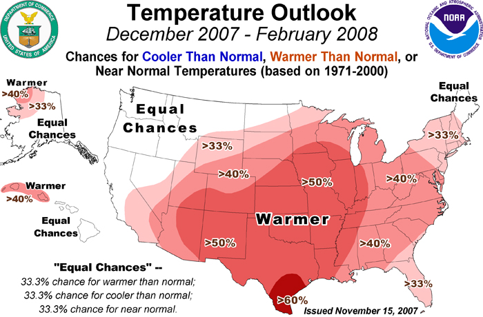
NOAA Still Sees Above Average Temperatures for Most of the U.S. and Below Normal Precipitation Across the South. Colorado Expected to be Warmer, Average Precipitation.
![]() NOAA released its final 90 day winter forecast and little changed from earlier predictions. For Colorado that means the likelihood of warmer than normal temperatures, particularly in the southern part of the state. In terms of precipitation, they foresee equal chances for normal, above and below normal moisture while southern Colorado remains dry.
NOAA released its final 90 day winter forecast and little changed from earlier predictions. For Colorado that means the likelihood of warmer than normal temperatures, particularly in the southern part of the state. In terms of precipitation, they foresee equal chances for normal, above and below normal moisture while southern Colorado remains dry.
“Although we are expecting a warmer than normal winter, we do believe there will be fluctuations of warm weather and typical winter weather throughout the season,” said Edward O’Lenic, chief, forecast operations, NOAA Climate Prediction Center. “We encourage people to review winter weather risks for their particular area and information available online to help keep them safe when events do occur.”
|
|
|

Click here to read the complete report from NOAA.
Snow on the way? Looks like a good chance!
![]() The metro area is going through a bit of a dry spell with it having been 25 days (and counting) since our last measurable precipitation. Relief may be on the way toward the middle of next week. The National Weather Service’s outlook says:
The metro area is going through a bit of a dry spell with it having been 25 days (and counting) since our last measurable precipitation. Relief may be on the way toward the middle of next week. The National Weather Service’s outlook says:
“The jet stream will switch from a westerly flow to a northerly flow Tuesday. This flow will persist into next weekend. This will bring much cooler temperatures and a good chance for snow. There is still quite a bit of uncertainty when the periods of snow will occur. Currently the best chance for snow will be Tuesday night and Wednesday.“
Of course forecasting a weather event like this four or five days away is pretty hard. Current indications show the storm arriving around midday Tuesday and hanging around through Wednesday morning. Computer models are saying less than 6″ of snow is expected across northeastern Colorado while the majority of the precipitation heads southeast onto the plains. Stay tuned for more information as it gets closer!