Late winter in Colorado can bring a wide variety of conditions, oftentimes within a very short time span. This was fully evident yesterday and last night as we went from a high of a daytime 62 degrees to receiving a healthy dose of snow before midnight.
Thornton received a total of 2.9 inches of heavy, wet snow from about 9:00 p.m. on March 4 through 1:00 a.m. on March 5. A healthy 0.45 inches liquid precipitation was recorded from the snow.
The time lapse video below captures the event from its start through sunrise. Below that is a satellite imagery time lapse from 7:00 a.m. to noon to show just how fast that snow disappeared.
Screenshot of an amazing time lapse video showing mountain wave clouds. (YouTube / BasehuntersChasing)
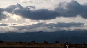
Watching clouds in real time can be fascinating however it is when they are sped up via time lapse that we can oftentimes truly see the subtle motions that we otherwise miss. A time lapse video released by some local storm chasers provide a stunning visual of wave clouds near Boulder.
Posted to YouTube today by Basehunters Chasing, the video showcases scenes captured over a couple of days along the Front Range.
Rolling mountain wave clouds serve as a backdrop to cows in a field. Watching closely, snow can be seen falling on the highest mountain peaks. Zoomed in views of a wave cloud follow showing the amazing motion.
Lastly a sunset is seen with the clouds starting pastel orange, then turning brilliant bright orange before fading away.
The video is set to a very soothing flute-type instrumental. Check it out below.
Satellites provide an amazing eye in the sky for monitoring the weather and climate. Their usefulness today was once again proven as they captures wildfires exploding in Colorado’s southwest and thunderstorms to the northeast.
The satellite imagery animation comes from the NOAA GOES East satellite and was assembled by Colorado State University RAMSDIS. It covers the period from 1:55pm to 4:40pm on Friday, June 21, 2013.
The tandem West Form Fire and Papoose Fire in southwestern Colorado are seen sending massive smoke plumes into the sky. Afternoon thunderstorms are exploding in the northeastern corner of the state.
One of our favorite pastimes is simply watching the clouds. Colorado’s widely varying weather provides a stunning variety in almost every season. One photographer captured an amazing time lapse video of what he called “Bubbly Rocky Mountain Clouds.”
April 15, 2013 - Snow far exceeding forecast amounts made for a wintry tax day in Thornton. (ThorntonWeather.com)
Mother Nature delivered a potent blast of wintry weather for Tax Day catching forecasters and residents off guard. The mid-April snowstorm brought a hefty shot of snow and cold temperatures to Denver and northeastern Colorado.
Two days before the event models pointed to significant snowfall for Tax Day. Soon however those same models shifted their target to the north and the metro area was only expected to receive light snow.
The heavy snow moved further south than anticipated however and by mid-afternoon on Monday, April 15 the storm was getting started in earnest. Snowfall rates of up to 2 inches per hour were seen from then through midnight.
The video below captures 24 hours of the event from 6:00am on April 15 to 6:00am to April 16. Only light snow is seen through about 2:00pm on the 15th before things really start to pick up.
The snow is falling, the wind is blowing and it is cold and nasty out there right now. We took to the street for a little bit to capture some video of our late spring snowstorm. Highlights include the flag flapping in the wind, blowing snow, shoveling and even an appearance by Scout, our Frisbee catching dog who doesn’t mind the snow one bit.
Update, 4:45pm: Below the first video taken this morning is a second video captured from our east facing webcam. It is a time lapse showing the past 24 hours compressed into 48 seconds.
Snow covers the streets with Thornton's March 4, 2013 snowstorm. Within a couple of hours the sun was out and the streets were clear. (ThorntonWeather.com)
March is historically the Denver area’s snowiest month and only four days into it Mother Nature delivered a nice, wet shot of the white stuff. The storm moved through quickly Monday afternoon and now we focus on a potentially significant storm this coming weekend.
Today Thornton recorded 2.4 inches of snow and a very welcome 0.15” of liquid precipitation from it. Similar totals, many a bit less, were seen in other locations of the Denver metro area.
This brings Thornton’s seasonal snow total to 28.9 inches. That is still well below normal but given the progress made in recent weeks, we are hoping these storms continue to arrive.
As we discussed in this morning’s forecast, models are pointing toward a far more significant storm arriving as early as late Friday and lasting well into the weekend.
One model, the European ECMWF, has been relatively consistent with its projection of a powerful storm with a hefty shot of snow. Other models have been less optimistic but on later runs today they are starting to come in line with the same thinking.
The recent snowstorm didn’t bring all that much snow to Thornton, 6.9 inches, but it was our biggest snowfall in over a year and delivers some much needed precipitation. The light, fluffy snow was easily blown around by winds gusting in excess of 32 mph which limited visibility and made conditions outside harsh.
The video below captures the event from our east facing camera beginning at 6:00pm on Saturday, February 23, 2013 and continuing through 6:00am on Monday, February 25, 2013. Light snow is seen falling soon after 10:00pm on Saturday night and following a lull, really picks up by mid-morning Sunday.
The recent storm was certainly far less than impressive in reality. Thornton recorded a mere 3.6″ of snow and our seasonal snowfall totals continue to lag well below average.
However, when you take 24 hours of pictures taken at one minute intervals and combine them all into a single video you end up with a pretty neat 48 second time lapse. Below are videos from each of our webcams covering the period from noon on Wednesday, February 20 to noon on Wednesday, February 21.
Weather, natural disasters & climate news and information.
")
")