Tag Archives: May weather

May 2014 weather recap: Temps near normal, a good bit wetter than normal

The month of May was a relatively benign, uneventful month in terms of the weather in Thornton. Average temperatures were right on par with normal while precipitation was generous.

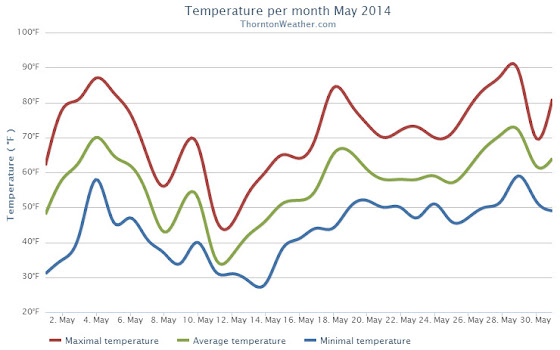
We started out the month with warming temperatures and by the third we were seeing highs in the 80s.  This only lasted a few days before cooler than normal temperatures settled in for a 10 day period.

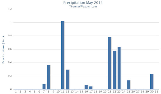
It was during that period that we recorded precipitation for six straight days.  This included a good shot of snow on the 11th and 12th.

Temperatures bounced back on the 18th and 19th with highs above 80 degrees but then settled down again to predominantly cooler than normal conditions for the next week.  The period from the 20th to the 25th also saw a return to wet conditions.

Warmer and dry conditions returned for a few days and then we closed out the month with cooler temperatures and some more rain.

Thornton finished the month with an average temperature of 56.9 degrees.  This was just a hair lower than Denver’s May average of 57.1 degrees.  The Mile High City’s average temperature came in warmer at 57.5 degrees.

The hottest temperature recorded occurred on the 29th with a reading of 88.7 degrees.  The coldest temperature of 28.5 degrees was on the 14th.  Denver’s warmest reading was 85 degrees on the 4th and its coldest of 30 degrees was on the 12th.

In terms of precipitation, Thornton saw a healthy 4.26 inches of liquid precipitation.  This was well above the May average of 2.12 inches.  Similarly, Denver saw above normal precipitation with a reading of 3.51 inches.

Snow fell on two days and totaled 4.3 inches in Thornton. Out at DIA, only 1.1 inches was recorded.  Average snowfall for May in Denver is 1.1 inches.

Click here to view Thornton’s May 2014 climate report.

http://www.thorntonweather.com/climatedataout52014.html

The Thornton, Colorado temperature summary for May 2014. (ThorntonWeather.com)


The Thornton, Colorado precipitation summary for May 2014. (ThorntonWeather.com)
CLIMATE REPORT
NATIONAL WEATHER SERVICE BOULDER, CO
642 AM MDT SUN JUN 1 2014
 
...................................
 
...THE DENVER CO CLIMATE SUMMARY FOR THE MONTH OF MAY 2014...
 
CLIMATE NORMAL PERIOD 1981 TO 2010
CLIMATE RECORD PERIOD 1872 TO 2014
 
WEATHER         OBSERVED          NORMAL DEPART LAST YEAR`S
                 VALUE   DATE(S) VALUE   FROM    VALUE DATE(S)
                                          NORMAL
................................................................
TEMPERATURE (F)
RECORD
 HIGH              95   05/26/1942
 LOW               19   05/02/2013
                        05/03/1907
HIGHEST            87   05/28        95      -8       88 05/17
                        05/29
LOWEST             30   05/12        19      11      19 05/02
AVG. MAXIMUM     70.6              71.5    -0.9     71.7
AVG. MINIMUM     44.5              42.7     1.8     44.1
MEAN             57.5              57.1     0.4     57.9
DAYS MAX >= 90      0               0.8    -0.8        0
DAYS MAX <= 32      0               0.0     0.0        0
DAYS MIN <= 32      4               1.9     2.1        4
DAYS MIN <= 0       0               0.0     0.0        0
 
PRECIPITATION (INCHES)
RECORD
 MAXIMUM         8.57   1876
 MINIMUM         0.06   1974
TOTALS           3.51              2.12    1.39     0.82
DAILY AVG.       0.11              0.07    0.04     0.03
DAYS >= .01        13               9.4     3.6        7
DAYS >= .10         6               4.8     1.2        3
DAYS >= .50         3               1.2     1.8        0
DAYS >= 1.00        1               0.2     0.8        0
GREATEST
 24 HR. TOTAL    1.39   05/20 TO 05/21              0.33 05/07 TO 05/08
 
SNOWFALL (INCHES)
TOTALS            1.1               1.1              3.4
 
DEGREE_DAYS
HEATING TOTAL     244               265     -21      253
 SINCE 7/1       5974              5996     -22     6055
COOLING TOTAL      21                21       0       42
 SINCE 1/1         21                22      -1       42
 
FREEZE DATES
RECORD
 EARLIEST     09/08/1962
 LATEST       06/08/2007
EARLIEST                        10/07
LATEST                          05/05
.........................................................
 
WIND (MPH)
AVERAGE WIND SPEED              10.6
RESULTANT WIND SPEED/DIRECTION   1/181
HIGHEST WIND SPEED/DIRECTION    37/330    DATE 05/21
HIGHEST GUST SPEED/DIRECTION    42/330    DATE 05/21
 
SKY COVER
POSSIBLE SUNSHINE (PERCENT)   MM
AVERAGE SKY COVER           0.70
NUMBER OF DAYS FAIR            3
NUMBER OF DAYS PC             18
NUMBER OF DAYS CLOUDY         10
 
AVERAGE RH (PERCENT)     55
 
WEATHER CONDITIONS. NUMBER OF DAYS WITH
THUNDERSTORM              0     MIXED PRECIP               0
HEAVY RAIN                2     RAIN                       6
LIGHT RAIN               17     FREEZING RAIN              0
LT FREEZING RAIN          1     HAIL                       1
HEAVY SNOW                0     SNOW                       2
LIGHT SNOW                2     SLEET                      1
FOG                      11     FOG W/VIS <= 1/4 MILE      3
HAZE                      3
 
- INDICATES NEGATIVE NUMBERS.
R INDICATES RECORD WAS SET OR TIED.
MM INDICATES DATA IS MISSING.
T INDICATES TRACE AMOUNT.

May 2014 top shots: Monthly photo slideshow

May can bring just about any type of weather to Colorado and amazing sunsets like this are quite common. (LE Worley)

The month of May can bring just about any type of weather to Thornton and Colorado.  Snow is still possible although pleasant days sometimes interrupted by spring severe weather are more common.  Our photo slideshow for the month captures the widely varying weather.

  • Slideshow updated May 26, 2014

Showcasing images captured by ThorntonWeather.com readers as well as some of our own, our monthly slideshow covers the entire gamut of weather-related imagery.

Sunsets, sunrises, wildlife and of course every type of weather condition are vividly depicted.  May brings some very dynamic weather and the photos are a great way to see the stunning variety.

To learn more about how to send your photo to us for inclusion in the slideshow, see below the slideshow.

Click the play button below and sit back and enjoy the images.

What is missing in the slideshow above?  Your photo!

Our monthly photo slideshow is going to feature images that we have taken but more importantly images that you have captured.  The photos can be of anything even remotely weather-related.

Landscapes, current conditions, wildlife, pets, kids.  Whimsical, newsy, artsy.  Taken at the zoo, some other area attraction, a local park, a national park or your backyard.  You name it, we want to see and share it!

Images can be taken in Thornton, Denver or anywhere across the extraordinary Centennial State.  We’ll even take some from out of state if we can tie it to Colorado somehow.

We’ll keep the criteria very open to interpretation with just about any image eligible to be shown in our slideshows.

What do you win for having your image in our slideshow?  We are just a ‘mom and pop’ outfit and make no money from our site so we really don’t have the means to provide prizes.  However you will have our undying gratitude and the satisfaction that your images are shared on the most popular website in Thornton.

To share you images with us and get them included in the slideshow just email them to us or share them with ThorntonWeather.com on any of the various social media outlets.  Links are provided below.

So come on, get those camera’s rolling!

Photos, video from 11 years ago showcase potential snow damage from coming storm

May 10, 2003 - Heavy, wet snow weighed down trees, damaging many. (ThorntonWeather.com)
May 10, 2003 – Heavy, wet snow weighed down trees, damaging many. Click for a larger view. (ThorntonWeather.com)

With a significant spring storm set to impact our area tonight through tomorrow, a similar storm 10 years ago today provides a reminder of the potential for damage.

From May 9 to May 10, 2003, heavy, wet snow fell on the Denver area, much of it focused over northern suburbs like Thornton.  Power lines were downed and trees took a beating.

Here in Thornton we received 7 inches as did Broomfield and DIA.

The National Weather Service ‘day in history’ noted:

“In 2003…a late spring snowstorm hammered the mountains… Eastern foothills…and urban corridor. The heaviest snowfall occurred north of Interstate 70. The heavy wet snow caused damage to trees throughout metro Denver and downed power lines. About 40 thousand people along the urban corridor were without power. Storm total snowfall amounts included: 11.5 inches in Louisville… 8 inches in Boulder and Broomfield; 7 inches in Thornton…Broomfield…at Denver International Airport… And at the site of the former Stapleton International Airport; and 6 inches 4 miles east of Denver. Snowfall ranged from 4 to 9 inches across extreme southern weld County. In the foothills…15 inches of snow fell near Jamestown…9 inches at Rollinsville and Rawah…with 8 inches at Chief Hosa and atop Lookout Mountain. The snow was accompanied by thunder on the afternoon of the 9th at Denver International Airport where west winds gusted to 25 mph on the 9th and north winds gusted to 22 mph on the 10th.”

The image to the right and the photos and video were taken in the ThorntonWeather.com backyard as the storm started to come to an end.

May 10, 2003 - Heavy, wet snow weighed down trees, damaging many. Click for a larger view.  (ThorntonWeather.com)
May 10, 2003 – Heavy, wet snow weighed down trees, damaging many. Click for a larger view. (ThorntonWeather.com)
May 10, 2003 - Heavy, wet snow weighed down trees, damaging many.  Click for a larger view. (ThorntonWeather.com)
May 10, 2003 – Heavy, wet snow weighed down trees, damaging many. Click for a larger view. (ThorntonWeather.com)

Thornton’s May preview: From snow to severe storms

Thornton, Colorado May 2013 weather preview.

Colorado’s famously highly variable weather seems to showcase itself during the month of May when a variety of weather conditions can be seen.

Winter-like temperatures and snow are possible as are mid-summer like temperatures or the more typical spring severe weather.

As the month starts out in 2014 we are going to enjoy a mild period with unseasonably warm temperatures and dry conditions.  Long range forecasts predict a relatively ‘normal’ May.

However the month can bring extremes.  Snow is not entirely uncommon during the month, oftentimes causing damage to newly bloomed trees.  More common however is severe weather, particularly in the latter half of the month.  Thunderstorms become more frequent and their associated hazards – lightning, wind, hail and tornadoes – are usual visitors.

For a complete look at what lies ahead for the month of May, check out our full preview here.

May 2013 weather recap: Drier, warmer weather return

Following on colder and wetter than normal weather in previous months, Thornton’s May returned us to drier and warmer than normal conditions.

The month started out with a bit of a wintry blast of cold temperatures and snow.  In fact, Denver even set an all-time May low temperature on the 2nd of the month.

The cold and snow that started the month were probably overall the most notable feature of the month.  The rest of May was not particularly extraordinary in any aspect.

Denver’s average temperature for the month was 57.9 degrees.  This was 0.8 degrees above average.  Here in Thornton we were just slightly cooler with an average temperature of 57.6 degrees.

Thornton’s temperatures ranged from a high of 89.2 degrees on the 14th down to a low of 20.7 degrees on the morning of the 2nd.  Denver saw a maximum temperature of 88 and a low of 19 degrees.

Official Denver temperature records for the month included:

DAILY RECORDS:

DATE        TEMPERATURE     TYPE OF RECORD     OLD RECORD   YEAR LAST SET
MAY 2ND     19 DEGREES        RECORD LOW       22 DEGREES       1954
MAY 14TH    87 DEGREES     TIED RECORD HIGH    87 DEGREES       1996

MONTHLY RECORDS:

DATE        TEMPERATURE     TYPE OF RECORD     OLD RECORD   YEAR LAST SET
MAY 2ND     19 DEGREES      TIED RECORD LOW    19  DEGREES   MAY 3RD 1907

In terms of precipitation, Denver recorded only 0.82 inches, far below the average for May of 2.12 inches.  Here in Thornton Mother Nature was far more generous as we recorded 2.35 inches.

The snow that started the month totaled 4.3 inches in Thornton, 3.4 inches in Denver.  Both were well above the May average of 1.1 inches snowfall.

Click here to view the ThorntonWeather.com May 2013 Climate Summary

Thornton, Colorado May 2013 Temperatures.
Thornton, Colorado May 2013 Precipitation.

May 19 to May 25: This Week in Denver Weather History

This Week In Denver Weather History
May 19 to May 25: This Week in Denver Weather History

Severe weather takes to the forefront in our look back at this week in Denver weather history. We see many historical flooding events that were commonplace in the late 19th / early 20th century before controls were put in place. Almost everyone will recall the Windsor tornado, an EF3 monster that struck the town five years ago.

From the National Weather Service:

18-19

In 2011…a severe thunderstorm in central Adams County produced large hail and heavy rainfall on the 18th. Large hail from 1 inch to 1 3/4 inches in diameter…was reported in Commerce City…2 miles south-southeast of federal heights…Northglenn…and 2 miles south of Thornton.

In Commerce City…the storm uprooted trees and knocked out power lines. A carport was lifted off the ground and struck the power lines overhead. Heavy rain…from 1.0 to 1.5 inches fell in less than 2 hours in Commerce City and near Brighton. The combination of hail and strong winds broke windows in Northglenn.

In the foothills…moderate to heavy snow showers developed overnight. Storm totals included: 10.5 inches at Gold Hill…9.5 inches…3 miles west of Jamestown; 9 inches at Lake Eldora; with 6 inches… 11 miles southwest of Gilpin and 4 miles east-northeast of Nederland. At Denver International Airport…total rainfall over the 2-day period totaled 1.71 inches.

In addition…a peak wind gust to 37 mph was recorded on the 18th.

18-20

In 1915…3.9 inches of snow fell in the city. The estimated amount of snow that melted as it fell was 6.2 inches which would have totaled an estimated 10.1 inches of snowfall. Precipitation totaled 1.03 inches. North winds were sustained to 32 mph on the 18th. Low temperatures dipped to 25 degrees on both the 18th and 20th…establishing record minimums for both dates.

In 1988…prolonged heavy rainfall drenched metro Denver. The event began when heavy thunderstorms on the 18th caused some street flooding and power outages…followed by steady rain on the 19th and 20th. Rain amounts across metro Denver totaled 3 to 4 inches. Rainfall totaled 3.71 inches at Stapleton International Airport where north winds gusted to 39 mph on the 20th. Four to eight inches of snow fell in the foothills above 7 thousand feet.

19

In 1927…southeast winds were sustained to 40 mph with gusts to 44 mph.

In 1956…a thunderstorm wind gust to 54 mph was recorded at Stapleton International Airport.

In 1969…hail stones to 1 inch in diameter were measured in Arvada and Aurora. Some minor damage was reported. Pea to marble size hail fell in Westminster.

In 1972…a tornado was reported by aircraft about 5 to 10 miles east of Parker.

In 1988…lightning started a fire at a house in the Denver suburb of greenwood village…causing 2 thousand dollars in damage.

In 1991…strong thunderstorms over east metro Denver produced wind gusts of 56 to 60 mph. The strong winds downed power lines…trees…and fences at some locations in Aurora. Thunderstorm outflow winds gusted to 60 mph at Stapleton International Airport.

In 1994…severe thunderstorms rumbled across metro Denver. The storms produced wind gusts averaging 65 mph and hail up to dime size. Wind gusts to 77 mph were recorded in Brighton. Numerous trees and power poles were downed by the winds. One power pole fell onto spectators at a high school graduation ceremony in Commerce City…injuring 6 people. In Fort Lupton…trees fell onto 2 parked cars… Knocking out the windshields. Hail to 3/4 inch in diameter was reported in Littleton. A thunderstorm wind gust to 52 mph was recorded at Stapleton International Airport.

In 1995…a slow moving tornado…which was mainly discernible by its dust and debris cloud…was spotted 2 miles northeast of Denver International Airport or about 10 miles northwest of Bennett. No damage was reported.

In 2007…lightning struck a 33-ft statue of Jesus at Mother Cabrini Shrine…in the foothills west of Golden. The blast broke off one of the statue’s arms and a hand…and also damaged a foot. It cost an estimated $200000 to repair.

In 2009…lightning struck the roof of a residence in Highlands Ranch. The home was not a total loss…but the fire caused extensive damage.

In 2010…a thunderstorm produced hail up to 7/8 inch in diameter in Thornton.

19-20

In 1864…a devastating major flash flood occurred on the normally dry and sandy Cherry Creek in Denver. The flood was caused by heavy thunderstorm rainfall and hail over the palmer ridge to the south of the city in both the Cherry Creek and plum creek basins. Nineteen deaths occurred along the South Platte River and Cherry Creek in Denver. The torrent swept cattle and sheep along with large trees and houses before it washing out several bridges…and moving large structures from their foundations. All city records were destroyed when city hall washed away. The rocky mountain news building…built on stilts in the middle of the creek…was totally destroyed by the raging waters…which were as deep as 5 feet on the morning of the 20th. Once the flood waters receded…much sand and gravel was left behind. Property damage from the flood was estimated at nearly one million dollars. This was the first major flood of record in the city.

Continue reading May 19 to May 25: This Week in Denver Weather History

May 12 to May 18: This Week in Denver Weather History

This Week In Denver Weather History
May 12 to May 18: This Week in Denver Weather History

The snow is gone – almost – but as our look back at this week in Denver weather history shows, it could return. That however is unlikely and more typical spring severe weather is far more common.

From the National Weather Service:

10-12

In 2011…a spring snowstorm brought heavy snow to the Front Range foothills and Palmer Divide. Storm totals included: 18 inches…4 miles south-southeast of Pinecliffe; 16 inches in Coal Creek Canyon; 15 inches…4 miles west-southwest of Eldorado Springs; 13 inches at Gold Hill…12 inches…4 miles west-southwest of Conifer and 4 miles northwest of Elizabeth; 11.5 inches…6 miles southwest of Evergreen and 4 miles east-northeast of Nederland; 11 inches…3 miles east of Jamestown and 10.5 inches…3 miles east of Franktown and 3 miles south of Golden and 10 inches…10 miles north of Elizabeth. At Denver International Airport… 1 inch of snowfall was observed.

12

In 1875…two forest fires on the eastern slope of the foothills were visible from the city.

In 1904…north winds were sustained to 40 mph with gusts to 48 mph.

In 1950…brilliant and complete primary and secondary rainbows arching across the sky were observed from Stapleton Airport.

In 1951…a wind gust to 51 mph was recorded at Stapleton Airport.

In 1984…winds gusted to 69 mph in Boulder. Northwest winds gusted to 47 mph at Stapleton International Airport.

In 1987…a small weak tornado touched down for about 2 minutes in southeast Denver. The twister hit a car dealership…blowing about a dozen windows out of cars and shattering four skylights on the building. Some tin roofing was blown off a patio a block and a half away. The tornado also downed a power pole. Damage at the dealership was estimated at 10 thousand dollars. A man was slightly injured by lightning in northwest Aurora.

In 1995…several funnel clouds were sighted near Parker. One of the funnels produced a short-lived debris cloud on the ground in an open field. No damage was reported.

12-13

In 1907…the temperature warmed to a high of 73 degrees on the 12th…before a cold front produced a thunderstorm… Northeast winds sustained to 40 mph…and rain changing to light snow overnight. Snowfall totaled only 2 inches…but the high temperature on the 13th was only 39 degrees.

In 1961…a storm that covered metro Denver with rain and snow started as thunderstorms on the evening of the 12th. Hail to 1 1/2 inches in diameter was reported 10 miles northwest of Stapleton Airport. Rain continued overnight and changed to snow on the 13th. Snowfall totaled 6.4 inches and precipitation (rain and melted snow) 1.96 inches at Stapleton Airport where north winds gusted to 39 mph. The rain and heavy wet snow caused icing damage to utility lines. Heavy snow occurred in the foothills.

In 1982…a major storm dumped 1.50 to 3.50 inches of rain across northeast Colorado and deposited prodigious amounts of snow in the foothills. Coal Creek Canyon southwest of Boulder was buried under 46 inches of snow with 39 inches at Nederland. The heavy wet snow downed many power lines in the foothills. In Thornton…the roof of a school was damaged by water from the heavy rain. At Stapleton International Airport…1.49 inches of rain were measured over the two day period. The heavy rain ended a severe and prolonged drought.

In 2004…a winter storm produced heavy snow in excess of a foot in the foothills above 6 thousand feet while heavy rain fell across the city. The heaviest snow occurred in the high country of Boulder County. Storm total snowfall was 14.5 inches near Jamestown. Rainfall totaled 0.81 inch at Denver International Airport with 0.94 inch recorded at Denver Stapleton. A trace of snow was recorded at both locations. East winds gusted to 24 mph at Denver International Airport on the 12th.

13

In 1905…a thunderstorm produced hail during the late afternoon. Precipitation totaled 0.57 inch.

13-14

In 1912…heavy snowfall totaled 12.4 inches over the city. Most of the snow…9.9 inches…fell on the 13th…which was the greatest 24 hour snowfall in May at the time. This was the last snowfall of the season. The low temperature dipped to 27 degrees on the morning of the 14th.

In 1989…a spring storm brought heavy rain and snow to the foothills. Metro Denver was soaked with 1 to 2 inches of rain. Rainfall totaled 1.26 inches at Stapleton International Airport.

In the foothills…Echo Lake received 20 inches of snow. A 30-ton Boulder slid onto I-70 east of the Eisenhower Tunnel…closing the freeway for 2 hours.

Continue reading May 12 to May 18: This Week in Denver Weather History

May 5 to May 11: This Week in Denver Weather History

This Week In Denver Weather History
May 5 to May 11: This Week in Denver Weather History

This time of year the focus is usually on spring severe weather with lightning, tornadoes and hail being the highlight. Our look back at this week in Denver weather history shows many of those types of events. Also notable are the few, unusually late in the season snow events, some of which were quite heavy.

From the National Weather Service:

1-5

In 1898…snowfall totaled 15.5 inches in downtown Denver. Most of the snow…6.2 inches…fell on the 3rd. Most of the snow melted as it fell. The greatest snow depth on the ground was only 2.5 inches on the 3rd at 8:00 pm. This was the only snowfall during the month. Northeast winds were sustained to 22 mph on the 1st.

2-5

In 2001…a very slow moving pacific storm system became parked near the four corners region…which allowed heavy snow to develop above 6500 feet in the foothills with a mix of rain and snow over lower elevations of metro Denver. Snowfall totals included: 21 inches atop Crow Hill and at Idaho Springs; 19 inches near Blackhawk; and 18 inches in Coal Creek Canyon…Genesee…and 11 miles southwest of Morrison. Snowfall totaled 6.2 inches at the site of the former Stapleton International Airport. Precipitation (rain and melted snow) totaled 2.09 inches at Denver International Airport where north winds gusted to 30 mph on the 2nd.

3-5

In 1908…rain changed to snow on the evening of the 3rd and continued through the early evening of the 5th. Snowfall totaled 10.0 inches over downtown Denver. This was the last measurable snow of the season. Precipitation totaled 1.51 inches. North winds were sustained to 23 mph on the 3rd…33 mph on the 4th…and 21 mph on the 5th. Three temperature records were set. High temperatures of 30 degrees on the 4th and 38 degrees on the 5th were record low maximum temperatures for the dates. The reading on the 4th was also the all-time record low maximum for the month of May.

In 2007…a slow moving pacific storm system…from the desert southwest…brought a period of unsettled weather to the region. During the 3-day period…locally heavy snow was reported over parts of the Front Range foothills. Storm totals included: 15 inches near Conifer…14.5 inches west of Jamestown…13.5 inches; 6 miles southwest of Evergreen…and 12.5 inches at pine junction. Severe thunderstorms…producing large hail…up to one inch in diameter were observed in the vicinity of Boulder and Hudson. Lightning struck a residence in Jefferson County. The roof was hit…causing the attic to catch fire. At Denver International Airport…lightning struck a United Airlines jet as it was pushing away from the gate. The passengers were taken off the jet and put on another plane.

4-5

In 1986…high winds buffeted the foothills. Wind speeds of 60 to 75 mph were recorded in Boulder. At Stapleton International Airport…west winds gusted to 45 mph on the 4th and to 40 mph on the 5th.

In 2000…a brief warm spell resulted in setting two daily high temperature records. The temperature climbed to highs of 87 degrees on the 4th and 89 degrees on the 5th.

4-8

In 1969…heavy rains caused flooding on Boulder creek in Boulder…which resulted in one death on the 7th. Flooding also occurred on bear creek in Sheridan and on the South Platte River in Denver. Rain over most of the eastern foothills started late on the 4th and continued with only brief interruptions in many areas until the morning of the 8th. Very high rates of rainfall occurred on the 6th and 7th with the greatest intensities in a band along the foothills from about 25 miles southwest of Denver northward to Estes Park. Storm totals by both official and unofficial measurements exceeded 10 inches over much of this area and were over 12 inches in some localities. Heavy snow fell in the higher mountains and in the foothills later in the period. The saturation of the soil resulted in numerous rock and landslides…and the heavy run-off caused severe damage along many streams and flooding on the South Platte River. Many foothill communities were isolated as highways were blocked and communications disrupted. Roads were severely damaged over a wide area…and a large number of bridges washed out. Many roads were closed due to the danger from falling rocks. A building in Georgetown collapsed from the weight of heavy wet snow. In Boulder…a man drowned when caught by the flooding waters of Boulder Creek…and a patrolman was injured. Rainfall totaled 7.60 inches in Boulder with 9.34 inches recorded at the Public Service Company electric plant in Boulder Canyon. In Morrison…rainfall totaled 11.27 inches in 4 days. Heavy rainfall totaled 4.68 inches at Stapleton International Airport over 3 days from the 5th through the 7th. Rainfall of 3.14 inches was recorded in 24 hours on the 6th and 7th. Downstream flooding continued along the South Platte River until the 12th when the flood crest reached the Nebraska line.

5

In 1903…apparent post-frontal northeast winds were sustained to 48 mph with gusts to 60 mph.

In 1950…a northwest wind gust to 52 mph was recorded at Stapleton Airport.

In 1969…a funnel cloud was observed for 2 to 3 minutes just north of Parker. Two other funnel clouds were sighted in the same area. The public sighted a tornado 15 miles east of Stapleton International Airport. No damage was reported.

5-6

In 1907…rain changed to snow on the 5th…continued through the night…and totaled 3.50 inches. Northeast winds were sustained to 15 mph on the 5th.

In 1917…post-frontal rain changed to heavy snow and totaled 12.5 inches over downtown Denver. Most of the snow… 12.0 inches…fell on the 5th and this was the greatest 24-hour snowfall ever measured during the month of May. This was also the only measurable snow of the month that year. Low temperatures of 27 degrees on the 5th and 23 degrees on the 6th were record minimums for the dates. High temperatures on both days were in the lower 40’s. Southeast winds were sustained to 24 mph with an extreme velocity to 26 mph.

In 1964…high winds gusted to 54 mph in Boulder and to 80 mph at Jefferson County Airport near Broomfield. Wind gusts of 50 to 60 mph were common over all of eastern Colorado. Buildings…power lines…trees…and vehicles were damaged by the wind. South-southwest wind gusts to 54 mph caused some blowing dust at Stapleton International Airport where the visibility was briefly reduced to 2 miles.

In 1973…a heavy driving rain storm with embedded thunderstorms…produced 1 to 5 inches of rain and caused local flash flooding along the east slopes of the Front Range. The greatest flash flooding occurred in metro Denver where rainfall totaled 3.56 inches at Stapleton International Airport. Flooding in metro Denver occurred on Clear Creek and the South Platte River…already swollen from heavy snowmelt. Numerous basements were flooded… Roads and streets were washed out…a bridge was demolished… And miscellaneous other damage was reported. North winds gusted to 39 mph at Stapleton International Airport during the storm. The storm produced major downstream flooding along the South Platte River all the way to the Nebraska border during the next two weeks. One person died and total damage was estimated at around 120 million dollars.

In 1978…heavy wet snow of around 24 inches collapsed an office and hotel building in Boulder. Many cars were abandoned in the city. Denver received 14 inches of heavy wet snow with Evergreen and Golden reporting 12 inches. Snowfall totaled 12.4 inches at Stapleton International Airport with a total accumulation of snow on the ground of 8 inches due to melting. Southeast winds gusted to 23 mph on the 5th. Temperatures both days remained in the lower to mid-30’s.

Continue reading May 5 to May 11: This Week in Denver Weather History

Denver breaks low temperature record for date, ties all time May low temperature

Record Cold Temperatures
Denver’s recent cold continued as this morning one low temperature record was broken, another tied.

In the wake of our May Day snowstorm, clear skies the following morning allowed temperatures to plummet and reach very winter-like levels.  As the mercury bottomed out, Denver broke one low temperature record and tied another.

As measured at Denver International Airport, the temperature this morning dropped to 19 degrees at 6:41am.  This easily breaks the previous record low temperature for May 2 of 22 degrees  set in 1954.

Most notably, the 19 degree reading also tied the record for the lowest temperature ever recorded during the month of May since record keeping began in Denver in 1872.   We have to go all the way back to May 3, 1907 to find a reading that low during May.

Here in Thornton we were quite cold as well although not quite as much as DIA.  Our morning low temperature of 20.7 degrees was seen at 6:00am.

The cold and snowy start to May mimics what was seen during the month of April.  Last month Denver recorded its fifth coldest and 11th snowiest April on record.

Thornton’s May weather preview: Everything from wintry weather to severe weather possible

Thornton, Colorado May 2013 weather preview.

Colorado’s famously highly variable weather seems to showcase itself during the month of May when a variety of weather conditions can be seen.

Winter-like temperatures and snow are possible as are mid-summer like temperatures or the more typical spring severe weather.

As the month starts out in 2013 we are going to receive a wintry blast with cold and snow.  This is not entirely unusual as Denver averages 1.7 inches of snow during the month since records began.

More common however is severe weather, particularly in the latter half of the month.  Thunderstorms become more frequent and their associated hazards – lightning, wind, hail and tornadoes – are usual visitors.

For a complete look at what lies ahead for the month of May, check out our full preview here.