Tag Archives: May weather

May 8 to May 11: This week in Denver weather history

This Week In Denver Weather History
May 8 to May 11: This week in Denver weather history

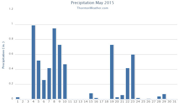
Think we are done with snow for the season? That may be the case this year but it isn’t always so. Looking back at this week in Denver history we do see snowfall has occurred along with more typical spring weather including heavy rains that led to flooding.

From the National Weather Service:

4-8

In 1969…heavy rains caused flooding on Boulder creek in Boulder…which resulted in one death on the 7th. Flooding also occurred on Bear Creek in Sheridan and on the South Platte River in Denver. Rain over most of the eastern foothills started late on the 4th and continued with only brief interruptions in many areas until the morning of the 8th. Very high rates of rainfall occurred on the 6th and 7th with the greatest intensities in a band along the foothills from about 25 miles southwest of Denver northward to Estes Park. Storm totals by both official and unofficial measurements exceeded 10 inches over much of this area and were over 12 inches in some localities. Heavy snow fell in the higher mountains and in the foothills later in the period. The saturation of the soil resulted in numerous rock and land slides…and the heavy run-off caused severe damage along many streams and flooding on the South Platte River. Many foothill communities were isolated as highways were blocked and communications disrupted. Roads were severely damaged over a wide area…and a large number of bridges washed out. Many roads were closed due to the danger from falling rocks. A building in Georgetown collapsed from the weight of heavy wet snow. In Boulder…a man drowned when caught by the flooding waters of Boulder Creek…and a patrolman was injured. Rainfall totaled 7.60 inches in Boulder with 9.34 inches recorded at the Public Service Company electric plant in Boulder Canyon. In Morrison…rainfall totaled 11.27 inches in 4 days. Heavy rainfall totaled 4.68 inches at Stapleton International Airport over 3 days from the 5th through the 7th. Rainfall of 3.14 inches was recorded in 24 hours on the 6th and 7th. Downstream flooding continued along the South Platte River until the 12th when the flood crest reached the Nebraska line.

7-8

In 1958…rainfall totaled 2.50 inches at Stapleton Airport.

8

In 1873…a very light rain fell until 5:00 am…when it turned into light snow and sleet and was accompanied by brisk northeast winds. The snow froze as it fell… Breaking the telegraph lines in many places. Precipitation totaled only 0.14 inch in the city.

In 1883…a severe rain and hailstorm struck the city. In 25 minutes the hail was 5 inches deep in the vicinity of the weather office in downtown Denver and reported as deep as 10 to 12 inches in other parts of the city. Gutters were blocked by the hail…and many cellars were flooded. Precipitation from the storm was 1.90 inches with the total for the day recorded at 2.02 inches. The size of the hail was not recorded.

In 1988…a wind gust to 68 mph was recorded at Echo Lake. Northwest winds gusted to 35 mph at Stapleton Airport.

In 1995…high winds of unknown strength blew a camper shell from the back of a pickup truck near Fort Lupton. North winds gusted to 49 mph at Denver International Airport.

In 1996…1 to 2 inch diameter hail was measured in Lochbuie northeast of Denver. Bean size hail fell in Brighton. The large hail fell from severe thunderstorms to the northeast of metro Denver.

In 2003…tornadoes touched down briefly near Brighton… Watkins…and Strasburg…but did no reported damage. Hail to 3/4 inch in diameter was measured near Hudson.

8-9

In 1957…intense heavy rain caused flash flooding on toll gate creek in Aurora where 3 people were killed in a car. Up to 4 inches of rain fell in 5 hours in the Toll Gate Creek basin. The rain also caused flash flooding on sand creek in Aurora and Denver. Rainfall totaled 3.29 inches at Stapleton Airport with most of the rain…2.34 inches… Occurring on the 9th.

8-10

In 1979…4.3 inches of snow fell at Stapleton International Airport where northwest winds gusted to 30 mph on the 8th. Most of the snowfall…2.3 inches…occurred on the 9th. High temperature of only 35 degrees on the 9th equaled the record low maximum for the date.

9

In 1875…a heavy windstorm swept across the city for most of the day. West-northwest winds averaged a sustained speed of 31 mph between 6:00 am and 3:00 pm. The peak wind was sustained to 45 mph at 9:50 am.

In 1918…post-frontal winds were sustained to 40 mph with gusts as high as 43 mph. Only a trace of rain fell.

In 1941…a tornado was noted at 2:20 pm to the northeast of downtown and was followed by another similar shaped cloud or dust roll estimated 3 miles behind. Thick dust followed with heavy gusts of wind. The temperature fell 15 degrees in 10 minutes following the twister. The mild tornado did little damage except to unprotected frame structures. Winds were sustained to 50 mph with the passing of the tornado at Stapleton Airport. It was visible to observers for 10 minutes and was lost from sight as it traveled east into huge rolls of dust. Hail and rain followed with a few hailstones as large as 1/2 inch in diameter downtown. No damage was reported from the hail. Thunderstorm winds sustained to 31 mph produced blowing dust downtown. Precipitation was only 0.07 inch.

In 1983…streams swollen by recent rain and snowmelt caused an earthen dam to collapse…washing out portions of State Highway 67 near Deckers in southern Douglas County.

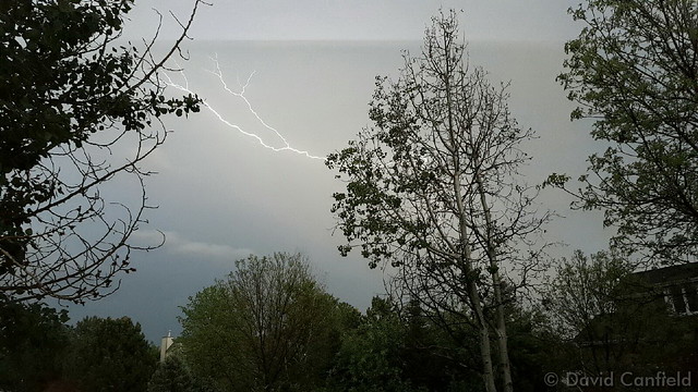
In 1992…three boys…ages 11…12…and 16…were struck by lightning while taking cover under a large tree during a thunderstorm in Jefferson County…just 7 miles northwest of Denver. The three were seriously injured.

9-10

In 1889…heavy rainfall totaled 2.15 inches in downtown Denver. The cold rain was mixed with snow at times overnight. Temperatures on the 10th ranged from a high of 38 degrees to a low of 32 degrees with north winds sustained to 22 mph.

In 2003…a late spring snowstorm hammered the mountains… Eastern foothills…and urban corridor. The heaviest snowfall occurred north of interstate 70. The heavy wet snow caused damage to trees throughout metro Denver and downed power lines. About 40 thousand people along the urban corridor were without power. Storm total snowfall amounts included: 11.5 inches in Louisville… 8 inches in Boulder and Broomfield; 7 inches in Thornton…Broomfield…at Denver International Airport… And at the site of the former Stapleton International Airport; and 6 inches 4 miles east of Denver. Snowfall ranged from 4 to 9 inches across extreme southern weld County. In the foothills…15 inches of snow fell near Jamestown…9 inches at Rollinsville and Rawah…with 8 inches at Chief Hosa and atop Lookout Mountain. The snow was accompanied by thunder on the afternoon of the 9th at Denver International Airport where west winds gusted to 25 mph on the 9th and north winds gusted to 22 mph on the 10th.

10

In 1875…a windstorm sand-blasted the city from 10:00 am until midnight. Northwest winds sustained to 60 mph brought clouds of sand…which caused high damage to unfinished buildings.

In 1912…a vigorous cold front produced strong north winds and rain. North winds were sustained to 48 mph with gusts as high as 60 mph. Rainfall totaled 1.10 inch.

In 1935…no precipitation occurred…making this one of only two days without precipitation during the entire month. The other day was the 21st. Precipitation totaled 4.95 inches for the month.

In 1956…northwest winds gusted to 53 mph at Stapleton Airport where the visibility was briefly reduced to 1/2 mile in blowing dust.

In 1974…strong winds caused 30 thousand dollars in damage to a building under construction in Lakewood. Microburst winds gusted to 46 mph at Stapleton International Airport.

In 1988…lightning struck a house in Boulder…setting it afire. The house…valued at 170 thousand dollars…was a total loss.

In 1989…golf ball size hail fell over southeast Denver near the junction of I-25 and I-225. Hail to 3/4 inch in diameter fell over southeast Aurora. Only 3/8 inch hail fell at Stapleton International Airport.

In 1991…high winds up to 63 mph raked the eastern foothills. Winds estimated to 50 mph tore a roof from a home in Lafayette. A tower at Jefferson County stadium in west metro Denver was blown over by the high winds. No injuries were reported. Southeast winds gusting to 48 mph at Stapleton International Airport produced some blowing dust. The temperature climbed to a high of 86 degrees… Equaling the record maximum for the date.

In 2005…severe thunderstorms produced hail as large as 2 inches in diameter in and near Longmont.
10-11 in 1918…post-frontal snowfall totaled 4.7 inches in downtown Denver. Northwest winds gusted to 19 mph on the 10th.

In 1923…winds were strong and gusty on both days. Northwest winds were sustained to 40 mph with gusts to 44 mph on the 10th. North winds were sustained to 39 mph with gusts to 46 mph behind an apparent cold front on the 11th.

10-12

In 2011…a spring snowstorm brought heavy snow to the Front Range Foothills and Palmer Divide. Storm totals included: 18 inches…4 miles south-southeast of Pinecliffe; 16 inches in Coal Creek Canyon; 15 inches…4 miles west-southwest of Eldorado Springs; 13 inches at Gold Hill…12 inches…4 miles west-southwest of Conifer and 4 miles northwest of Elizabeth; 11.5 inches…6 miles southwest of Evergreen and 4 miles east-northeast of Nederland; 11 inches…3 miles east of Jamestown and 10.5 inches…3 miles east of Franktown and 3 miles south of Golden and 10 inches…10 miles north of Elizabeth. At Denver International Airport…1 inch of snowfall was observed.

11

In 1879…an apparent cold front during the afternoon produced sustained north winds as high as 60 mph and great clouds of blowing dust. The dust filled the air until the thunderstorm rain began…which produced 1.46 inches of rainfall. The rain ended during the evening.

In 1900…southwest winds were sustained to 40 mph with gusts to 46 mph.

In 1958…a microburst caused a brief wind gust to 55 mph at Stapleton Airport.

In 1963…south-southwest winds gusted to 48 mph at Stapleton Airport. Winds May have been stronger over west Denver where some buildings were damaged.

In 1998…large hail fell over south metro Denver. Hail as large as 1 1/4 inches in diameter was measured in Parker with 1 inch hail recorded in Littleton and 4 miles south of Lakewood in Jefferson County. Hail to 3/4 inch diameter was measured in Douglas County…11 miles west- northwest of Parker.

11-12

In 2014…A strong storm system moved from southwest Colorado and produced heavy snow in and near the Front Range Foothills and metro Denver.  The snow was heaviest in the foothills where up to 2 1/2 feet of snow was observed. In the foothills…storm totals included: 30 inches near Pinecliffe; 29 inches…8 miles northeast of Four Corners; 28 inches near Pingree Park; 27 inches near Allenspark; 20.5 inches near Idaho Springs; 19.5 inches at Gold Hill; 19 inches near Genesee; 18 inches near Blackhawk; 17 inches at Aspen Springs; 16.5 inches near Ward; 13.5 inches at Bergen Park; with 11 inches at Evergreen.  Along Urban Corridor and Palmer Divide…stormtotals included: 10.5 inches at Eldorado Springs; 10 inches at Ken Caryl; 9 inches at Superior; 8 inches near Morrison; 7.5 inches in Broomfield and Highlands Ranch; 7 inches in Denver…near Franktown…Golden…Lakewood and Highlands Ranch; 6 inches…5 miles northeast of Westminster…7 miles south of Lyons and near Parker; with 5.5 inches at Aurora. At Denver International Airport…1.1 inches of snowfall was observed…along with 0.9 inches of water.

12

In 1875…two forest fires on the eastern slope of the foothills were visible from the city.

In 1904…north winds were sustained to 40 mph with gusts to 48 mph.

In 1950…brilliant and complete primary and secondary rainbows arching across the sky were observed from Stapleton Airport.

In 1951…a wind gust to 51 mph was recorded at Stapleton Airport.

In 1984…winds gusted to 69 mph in Boulder. Northwest winds gusted to 47 mph at Stapleton International Airport.

In 1987…a small weak tornado touched down for about 2 minutes in southeast Denver. The twister hit a car dealership…blowing about a dozen windows out of cars and shattering four skylights on the building. Some tin roofing was blown off a patio a block and a half away. The tornado also downed a power pole. Damage at the dealership was estimated at 10 thousand dollars. A man was slightly injured by lightning in northwest Aurora.

In 1995…several funnel clouds were sighted near Parker. One of the funnels produced a short-lived debris cloud on the ground in an open field. No damage was reported.

12-13

In 1907…the temperature warmed to a high of 73 degrees on the 12th…before a cold front produced a thunderstorm… Northeast winds sustained to 40 mph…and rain changing to light snow overnight. Snowfall totaled only 2 inches…but the high temperature on the 13th was only 39 degrees.

In 1961…a storm that covered metro Denver with rain and snow started as thunderstorms on the evening of the 12th. Hail to 1 1/2 inches in diameter was reported 10 miles northwest of Stapleton Airport. Rain continued overnight and changed to snow on the 13th. Snowfall totaled 6.4 inches and precipitation (rain and melted snow) 1.96 inches at Stapleton Airport where north winds gusted to 39 mph. The rain and heavy wet snow caused icing damage to utility lines. Heavy snow occurred in the foothills.

In 1982…a major storm dumped 1.50 to 3.50 inches of rain across northeast Colorado and deposited prodigious amounts of snow in the foothills. Coal Creek Canyon southwest of Boulder was buried under 46 inches of snow with 39 inches at Nederland. The heavy wet snow downed many power lines in the foothills. In Thornton…the roof of a school was damaged by water from the heavy rain. At Stapleton International Airport…1.49 inches of rain were measured over the two day period. The heavy rain ended a severe and prolonged drought.

In 2004…a winter storm produced heavy snow in excess of a foot in the foothills above 6 thousand feet while heavy rain fell across the city. The heaviest snow occurred in the high country of Boulder County. Storm total snowfall was 14.5 inches near Jamestown. Rainfall totaled 0.81 inch at Denver International Airport with 0.94 inch recorded at Denver Stapleton. A trace of snow was recorded at both locations. East winds gusted to 24 mph at Denver International Airport on the 12th.

13

In 1905…a thunderstorm produced hail during the late afternoon. Precipitation totaled 0.57 inch.

13-14

In 1912…heavy snowfall totaled 12.4 inches over the city. Most of the snow…9.9 inches…fell on the 13th…which was the greatest 24 hour snowfall in May at the time. This was the last snowfall of the season. The low temperature dipped to 27 degrees on the morning of the 14th.

In 1989…a spring storm brought heavy rain and snow to the foothills. Metro Denver was soaked with 1 to 2 inches of rain. Rainfall totaled 1.26 inches at Stapleton International Airport. In the foothills…Echo Lake received 20 inches of snow. A 30-ton Boulder slid onto I-70 east of the Eisenhower Tunnel…closing the freeway for 2 hours.

14

In 1910…a thunderstorm produced strong winds during the afternoon. Northwest winds were sustained to 42 mph.

In 1913…light moist snow and light hail fell during short intervals…although no thunder was heard. The trace of snowfall was the only snow of the month. Precipitation… Mostly rain…totaled 0.44 inch.

In 1984…a pilot reported a tornado 16 miles east of Stapleton International Airport. No damage was reported. A thunderstorm produced a 58 mph wind gust in Brighton. Thunderstorm winds gusted to 48 mph at Stapleton International Airport.

In 1989…lightning struck a home in Evergreen…setting it afire.

In 1992…strong thunderstorm winds of unknown velocity… Knocked over and damaged the infield tote board at Arapahoe park racetrack just southeast of Aurora. Damage was estimated at 200 thousand dollars. No injuries were reported. Lightning started two house fires…causing 35 hundred dollars in damage in Adams County just 9 miles north-northwest of Denver.

In 1994…a sudden wind gust…estimated at 40 mph…blew a portion of the roof off a shopping center in Lafayette. The roof also damaged two parked cars in an adjacent lot.

In 2001…a construction worker in Castle Rock received minor injuries when lightning struck close-by.

In 2002…a microburst wind gust to 53 mph was recorded at Denver International Airport.

In 2007…severe thunderstorms producing large hail…very heavy rain…and tornadoes impacted the urban corridor and adjacent plains. Heavy rain associated with a severe thunderstorm caused flooding along a small tributary draining into the South Platte River. The incident took place at 13th and Decatur St….near Invesco Field. The floodwaters inundated the bike trail adjacent to the creek. A woman with her child sought refuge under a bridge and became trapped by the high water. The woman slipped and the stroller containing the child was swept into the swift current. The child drowned. Rainfall totaled 0.42 inches at Denver International Airport. Elsewhere…golfball hail was reported near Hudson. Hail…up to one inch in diameter…was observed in Boulder and Lyons. Thunderstorm wind gusts estimated to 70 mph were reported near Buckley Air Force Base…with a peak wind gust to 37 mph observed at Denver International Airport. A small tornado touched down near Ft. Lupton but did no damage.

14-15

In 1977…high winds up to 100 mph felled hundreds of trees in Gilpin County and caused extensive damage to telephone and power lines. Lumber and steel tanks were blown around in Boulder canyon. West winds gusted to 46 mph at Stapleton International Airport on the 15th.

14-18

In 1996…a period of unusually warm weather resulted in 4 record maximum temperatures in 5 days. The record high temperatures were 87 degrees on the 14th…89 degrees on the 15th…and 93 degrees on both the 16th and 18th. The temperature climbed to only 81 degrees on the 17th which was not a record.

Thornton’s May weather preview: Anything from snow to severe storms

Thornton, Colorado May 2013 weather preview.
Thornton, Colorado May 2016 weather preview.

Colorado’s famously highly variable weather seems to showcase itself during the month of May when a variety of weather conditions can be seen.

Winter-like temperatures and snow are possible as are mid-summer like temperatures or the more typical spring severe weather.

As the month starts out in 2016 we see snow but then warmer, milder weather is expected to arrive for the balance of the first week of the month.  Long range forecasts lean toward overall cooler and wetter than normal conditions.

However the month can bring extremes.  Snow is not entirely uncommon during the month, oftentimes causing damage to newly bloomed trees.  More common however is severe weather, particularly in the latter half of the month.  Thunderstorms become more frequent and their associated hazards – lightning, wind, hail and tornadoes – are usual visitors.

For a complete look at what lies ahead for the month of May, check out our full preview here.

May 1 to May 7: This week in Denver weather history

This Week In Denver Weather History
May 1 to May 7: This week in Denver weather history

May can bring a variety of conditions from snow and cold to severe thunderstorms and flooding rains. Looking back at this week in Denver weather history we see where all of those events have made an appearance in our past.

From the National Weather Service:

29-2

In 1954…a major storm dumped 10.1 inches of snowfall at Stapleton Airport. Most of the snow…7.5 inches…fell on the 29th and 30th. The maximum snow depth on the ground was 5 inches on the 30th due to melting. No strong winds accompanied the storm.

30-1

In 1980…to the west of Denver…heavy rain changing to snow buried the foothills above 7 thousand feet in 4 to 8 inches of snow. Precipitation in the foothills ranged from 1 to 3 inches…which caused some local flooding. Rain fell at lower elevations. Rainfall at Stapleton International Airport totaled 1.05 inches from the storm.

1

In 1902…northwest winds were sustained to 68 mph with gusts as high as 74 mph in the city during the early morning. The apparent very strong Chinook winds warmed the temperature to a high of 78 degrees.

In 1912…south winds were sustained to 42 mph with gusts as high as 58 mph. South to southwest winds were strong all afternoon.

In 1935…a moderate duststorm blew into the city at around 2:00 pm on northwest winds sustained to 17 mph with gusts to 19 mph. Later in the afternoon…the dust receded to the east in advance of a rainstorm from the west.

In 1988…very strong winds behind a vigorous cold front produced a blinding dust storm that closed I-70 east of Denver. Northeast winds over metro Denver peaked to 45 mph at Stapleton International Airport…but only kicked up some blowing dust. The temperature plunged from a high of 76 degrees at midday to 36 degrees at midnight as light rain changed to light snow.

In 1991…3/4 inch diameter hail fell at Standley Lake in northwest metro Denver.

In 1999…heavy snow developed in the foothills above 7 thousand feet elevation. Snow totals included: 10 inches at Rollinsville…7 inches near conifer…and 6 inches atop Crow Hill. Rain fell across metro Denver.

1-2

In 1903…post-frontal rain changed to light snow overnight… But totaled only 2.0 inches. This was the last snow of the season. Northeast winds were sustained to 45 mph with gusts to 48 mph on the 1st.

1-5

In 1898…snowfall totaled 15.5 inches in downtown Denver. Most of the snow…6.2 inches…fell on the 3rd. Most of the snow melted as it fell. The greatest snow depth on the ground was only 2.5 inches on the 3rd at 8:00 pm. This was the only snowfall during the month. Northeast winds were sustained to 22 mph on the 1st.

2

In 1874…strong winds upset two railroad passenger coaches near Georgetown. The baggage was retrieved and placed in a heavy…large wagon. The passengers then seated themselves on top of the baggage. Another strong gust of wind upset the wagon. The driver’s shoulder was dislocated…and a passenger’s leg was badly injured. In Denver…northwest winds increased and blew in gusts and heavy winds were observed on the ridge tops. On the Kansas Pacific R.R. east of Denver…the wind was so strong that it blew the train back several lengths…which caused the train to be about 7 hours late arriving in the city.

In 1901…south winds were sustained to 50 mph with gusts to 60 mph from an apparent thunderstorm with hail.

In 1944…snowfall of 8.3 inches was accompanied by a thunderstorm. This was the last snowfall of the season and the only snow of the month. Northwest winds were sustained to 25 mph.

In 1955…southwest winds at speeds of 37 mph with gusts as high as 58 mph caused some blowing dust at Stapleton Airport.

In 1983…1 inch diameter hail fell a few miles south of Bennett.

In 1984…3/4 inch diameter hail fell in Northglenn.

In 1988…I-70 east of Denver was closed for the second straight day…this time due to snow and blowing snow producing up to 2 foot drifts. While only 2 to 4 inches of snow fell across metro Denver…Strasburg…just east of Denver…received a foot of snow. North winds peaked to 51 mph at Stapleton International Airport where snowfall totaled only 1.3 inches.

In 1995…lightning struck a house in Westminster sparking an attic fire.

2-3

In 1979…heavy rain changed to snow on the 2nd. Snowfall totaled 3.9 inches at Stapleton International Airport… Where northwest winds gusted to 26 mph. The greatest depth of snow on the ground was only 1 inch at midday on the 2nd due to melting. Total precipitation for the 2 days was 1.65 inches.

2-4

In 1987…a slow moving storm brought rain…wind…and snow to metro Denver. Rainfall totaled 1.04 inches at Stapleton International Airport where north winds gusted to 48 mph on the 3rd. The foothills received 5 to 10 inches of snow.

2-5

In 2001…a very slow moving pacific storm system became parked near the four corners region…which allowed heavy snow to develop above 6500 feet in the foothills with a mix of rain and snow over lower elevations of metro Denver. Snowfall totals included: 21 inches atop Crow Hill and at Idaho Springs; 19 inches near Blackhawk; and 18 inches in Coal Creek Canyon…Genesee…and 11 miles southwest of Morrison. Snowfall totaled 6.2 inches at the site of the former Stapleton International Airport. Precipitation (rain and melted snow) totaled 2.09 inches at Denver International Airport where north winds gusted to 30 mph on the 2nd.

3

In 1898…heavy snowfall of 6.2 inches fell over downtown Denver. Most of the snow melted as it fell. The greatest snow depth on the ground was 2.5 inches during the evening.

In 1907…the all-time lowest recorded temperature in the month of May…19 degrees…occurred.

In 1925…an apparent microburst produced sustained northeast winds to 44 mph with gusts to 52 mph. Rainfall was only 0.01 inch in downtown Denver.

In 1981…lightning struck 9 golfers at the south suburban golf course. None were injured seriously.

In 1983…hail 1 1/2 inches in diameter fell at Green Mountain west of Lakewood…with 3/4 inch stones reported in Lakewood.

In 1986…a thunderstorm wind gust to 51 mph was recorded at Stapleton International Airport.

3-5

In 1908…rain changed to snow on the evening of the 3rd and continued through the early evening of the 5th. Snowfall totaled 10.0 inches over downtown Denver. This was the last measurable snow of the season. Precipitation totaled 1.51 inches. North winds were sustained to 23 mph on the 3rd…33 mph on the 4th…and 21 mph on the 5th. Three temperature records were set. High temperatures of 30 degrees on the 4th and 38 degrees on the 5th were record low maximum temperatures for the dates. The reading on the 4th was also the all-time record low maximum for the month of May.

In 2007…a slow moving pacific storm system…from the desert southwest…brought a period of unsettled weather to the region. During the 3-day period…locally heavy snow was reported over parts of the Front Range foothills. Storm totals included: 15 inches near Conifer…14.5 inches west of Jamestown…13.5 inches; 6 miles southwest of Evergreen…and 12.5 inches at Pine Junction. Severe thunderstorms…producing large hail…up to one inch in diameter were observed in the vicinity of Boulder and Hudson. Lightning struck a residence in Jefferson County. The roof was hit…causing the attic to catch fire. At Denver International Airport…lightning struck a United Airlines jet as it was pushing away from the gate. The passengers were taken off the jet and put on another plane.

4

In 1893…northwest winds were sustained to 42 mph.

In 1971…a funnel cloud was sighted 10 miles southwest of Boulder. Hail stones to 1 inch in diameter fell in southeast Denver…but caused only minor damage.

In 2006…a severe thunderstorm produced hail to 1.00 inch in diameter in Aurora near Cheery Creek Reservoir.

In 2010…high winds downed trees and power lines across parts of the Front Range foothills and urban corridor. Downed power lines sparked a 12-acre wildfire near Conifer. In Boulder…Longmont and Louisville…the wind damaged roofs and broke windows and skylights. Peak wind gusts included: 75 mph in northwest Longmont…71 mph at the national wind technology center and 4 miles south-southwest of Superior…61 mph at Broomfield and 56 mph in Erie. At Denver International Airport…a peak wind gust to 46 mph was observed.

Continue reading May 1 to May 7: This week in Denver weather history

May 2015 weather recap: A very wet, cool month for Thornton

The first quarter of the year started out dry but April started to signal a turn toward wetter conditions and the month of May certainly followed through on that.  Not only was it a very wet month, it was also much cooler than normal.

A seemingly endless series of disturbances moved through the state almost from the first day through the last day of May 2015.  We started out dry but the third of the month began the wet period with five straight days of precipitation.  That was capped off by a decent shot of snowfall on the 10th of the month.

After that we did dry out for at least a few days before the wet weather returned on the 15th, albeit with lesser amounts of precipitation overall.  By the time the month was over, 18 of the 31 days had seen measureable precipitation in Thornton.

Temperatures were quite cool for the month with the average in Thornton coming in at 52.2 degrees.  This was nearly five degrees below Denver’s May average of 57.1 degrees.  As measured at Denver International Airport, the Mile High City officially saw an overage of 53.0 degrees.

Thornton’s mercury readings ranged from a high of 87.3 degrees on the 31st down to a low of 27.8 degrees on the morning of the 10th.  Denver saw its warmest reading of 85 degrees on the 31st also and its coldest reading of 27 degrees occurred on the 9th and 10th.

In terms of precipitation, the numbers help to showcase just how wet of a month it was.  Here in Thornton we recorded 6.40 inches of liquid precipitation, far above the long term Denver average for May of 2.12 inches.  Officially, Denver also saw above normal precipitation although not by near as much as they recorded 3.76 inches.

That reading was not enough to push May 2015 into the books as one of the top 10 wettest Mays.  However, the airport’s outlying location as compared to historical measurement sites is probably the only reason why.  As Thornton’s measurement and those of other station’s shows, we were far wetter than what DIA saw.

Snowfall in May is not unusual and Thornton saw 5.1 inches from one storm on the 9th and 10th.  Out at the airport 4.0 inches was recorded.  Both were a good bit above the May average of 1.1 inches.

Click here to view Thornton’s May 2015 climate report.

Thornton, Colorado's May 2015 temperature summary. (ThorntonWeather.com)
Thornton, Colorado’s May 2015 temperature summary. (ThorntonWeather.com)
Thornton, Colorado's May 2015 precipitation summary. (ThorntonWeather.com)
Thornton, Colorado’s May 2015 precipitation summary. (ThorntonWeather.com)
CLIMATE REPORT
NATIONAL WEATHER SERVICE BOULDER, CO
645 AM MDT MON JUN 1 2015

................................... 

...THE DENVER CO CLIMATE SUMMARY FOR THE MONTH OF MAY 2015... 

CLIMATE NORMAL PERIOD 1981 TO 2010
CLIMATE RECORD PERIOD 1872 TO 2015

WEATHER         OBSERVED          NORMAL  DEPART  LAST YEAR`S
                 VALUE   DATE(S)  VALUE   FROM    VALUE  DATE(S)
                                          NORMAL
................................................................ 
TEMPERATURE (F)
RECORD
 HIGH              95   05/26/1942
 LOW               19   05/02/2013
                        05/03/1907
HIGHEST            85   05/31                         87  05/28
                                                          05/29
LOWEST             27   05/10                         30  05/12
                        05/09
AVG. MAXIMUM     63.3              71.5    -8.2     70.6
AVG. MINIMUM     42.7              42.7     0.0     44.5
MEAN             53.0              57.1    -4.1     57.5
DAYS MAX >= 90      0               0.8    -0.8        0
DAYS MAX <= 32      0               0.0     0.0        0
DAYS MIN <= 32      3               1.9     1.1        4
DAYS MIN <= 0       0               0.0     0.0        0 
PRECIPITATION (INCHES) 
RECORD
  MAXIMUM         8.57   1876
  MINIMUM         0.06   1974
TOTALS           3.76              2.12    1.64     3.51 
DAILY AVG.       0.12              0.07    0.05     0.11 
DAYS >= .01        19               9.4     9.6       13
DAYS >= .10        10               4.8     5.2        6
DAYS >= .50         2               1.2     0.8        3
DAYS >= 1.00        1               0.2     0.8        1
GREATEST
 24 HR. TOTAL    1.18   05/08 TO 05/09           05/20 TO 05/21

SNOWFALL (INCHES)
TOTAL             4.0               1.1
RECORD MAY       15.5                                      1898

DEGREE_DAYS
HEATING TOTAL     367               265     102      244
 SINCE 7/1       5572              5996    -424     5974
COOLING TOTAL       4                21     -17       21
 SINCE 1/1          4                22     -18       21

FREEZE DATES
RECORD
 EARLIEST     09/08/1962
 LATEST       06/08/2007
NORMAL
 EARLIEST                         10/07
 LATEST                           05/05
.................................................. 

WIND (MPH)
AVERAGE WIND SPEED              9.3
RESULTANT WIND SPEED/DIRECTION   2/106
HIGHEST WIND SPEED/DIRECTION    45/280    DATE  05/02
HIGHEST GUST SPEED/DIRECTION    54/280    DATE  05/02

SKY COVER
POSSIBLE SUNSHINE (PERCENT)   MM
AVERAGE SKY COVER           0.80
NUMBER OF DAYS FAIR            0
NUMBER OF DAYS PC             15
NUMBER OF DAYS CLOUDY         16

AVERAGE RH (PERCENT)     70

WEATHER CONDITIONS. NUMBER OF DAYS WITH
THUNDERSTORM              0     MIXED PRECIP               0
HEAVY RAIN                2     RAIN                       9
LIGHT RAIN               23     FREEZING RAIN              0
LT FREEZING RAIN          0     HAIL                       0
HEAVY SNOW                1     SNOW                       1
LIGHT SNOW                2     SLEET                      0
FOG                      14     FOG W/VIS <= 1/4 MILE      7
HAZE                      3

-  INDICATES NEGATIVE NUMBERS.
R  INDICATES RECORD WAS SET OR TIED.
MM INDICATES DATA IS MISSING.
T  INDICATES TRACE AMOUNT.

May 2015 top shots: Monthly photo slideshow

Lightning streaks across the skies on May 6, 2015. (David Canfield)

Colorado’s famously highly variable weather seems to showcase itself during the month of May when a variety of weather conditions can be seen.  This provides a prime opportunity for photos of everything weather to flora to fauna.

The month of May can bring extremes.  Snow is not entirely uncommon during the month but more common is severe weather, particularly in the latter half of the month.  Thunderstorms become more frequent and their associated hazards – lightning, wind, hail and tornadoes – are usual visitors.  Providing additional subjects for pictures are the emerging spring flowers and our abundant wildlife.

  • Slideshow updated May 31, 2015. To learn more about how to send your photo to us for inclusion in the slideshow, see below the slideshow.

Showcasing images captured by ThorntonWeather.com readers as well as some of our own, our monthly slideshow covers the entire gamut of weather-related imagery.

Sunsets, sunrises, wildlife and of course every type of weather condition are vividly depicted in images captured from yours and our cameras.

[flickr_set id=”72157652075811140″]

What is missing in the slideshow above?  Your photo!

Our monthly photo slideshow is going to feature images that we have taken but more importantly images that you have captured.  The photos can be of anything even remotely weather-related.

Landscapes, current conditions, wildlife, pets, kids.  Whimsical, newsy, artsy.  Taken at the zoo, some other area attraction, a local park, a national park or your backyard.  You name it, we want to see and share it!

Images can be taken in Thornton, Denver or anywhere across the extraordinary Centennial State.  We’ll even take some from out of state if we can tie it to Colorado somehow.

We’ll keep the criteria very open to interpretation with just about any image eligible to be shown in our slideshows.

What do you win for having your image in our slideshow?  We are just a ‘mom and pop’ outfit and make no money from our site so we really don’t have the means to provide prizes.  However you will have our undying gratitude and the satisfaction that your images are shared on the most popular website in Thornton.

To share you images with us and get them included in the slideshow just email them to us or share them with ThorntonWeather.com on any of the various social media outlets.  Links are provided below.

So come on, get those camera’s rolling!

Thornton’s May weather preview: Everything from snow to severe storms

Thornton, Colorado May 2013 weather preview.
Thornton, Colorado May 2015 weather preview.

Colorado’s famously highly variable weather seems to showcase itself during the month of May when a variety of weather conditions can be seen.

Winter-like temperatures and snow are possible as are mid-summer like temperatures or the more typical spring severe weather.

As the month starts out in 2015 we are going to enjoy a mild period with unseasonably warm temperatures but with unsettled conditions.  Long range forecasts lean toward overall warmer than normal temperatures and above normal precipitation.

However the month can bring extremes.  Snow is not entirely uncommon during the month, oftentimes causing damage to newly bloomed trees.  More common however is severe weather, particularly in the latter half of the month.  Thunderstorms become more frequent and their associated hazards – lightning, wind, hail and tornadoes – are usual visitors.

For a complete look at what lies ahead for the month of May, check out our full preview here.

May 2014 weather recap: Temps near normal, a good bit wetter than normal

The month of May was a relatively benign, uneventful month in terms of the weather in Thornton. Average temperatures were right on par with normal while precipitation was generous.

We started out the month with warming temperatures and by the third we were seeing highs in the 80s.  This only lasted a few days before cooler than normal temperatures settled in for a 10 day period.

It was during that period that we recorded precipitation for six straight days.  This included a good shot of snow on the 11th and 12th.

Temperatures bounced back on the 18th and 19th with highs above 80 degrees but then settled down again to predominantly cooler than normal conditions for the next week.  The period from the 20th to the 25th also saw a return to wet conditions.

Warmer and dry conditions returned for a few days and then we closed out the month with cooler temperatures and some more rain.

Thornton finished the month with an average temperature of 56.9 degrees.  This was just a hair lower than Denver’s May average of 57.1 degrees.  The Mile High City’s average temperature came in warmer at 57.5 degrees.

The hottest temperature recorded occurred on the 29th with a reading of 88.7 degrees.  The coldest temperature of 28.5 degrees was on the 14th.  Denver’s warmest reading was 85 degrees on the 4th and its coldest of 30 degrees was on the 12th.

In terms of precipitation, Thornton saw a healthy 4.26 inches of liquid precipitation.  This was well above the May average of 2.12 inches.  Similarly, Denver saw above normal precipitation with a reading of 3.51 inches.

Snow fell on two days and totaled 4.3 inches in Thornton. Out at DIA, only 1.1 inches was recorded.  Average snowfall for May in Denver is 1.1 inches.

Click here to view Thornton’s May 2014 climate report.

http://www.thorntonweather.com/climatedataout52014.html

The Thornton, Colorado temperature summary for May 2014. (ThorntonWeather.com)


The Thornton, Colorado precipitation summary for May 2014. (ThorntonWeather.com)
CLIMATE REPORT
NATIONAL WEATHER SERVICE BOULDER, CO
642 AM MDT SUN JUN 1 2014
 
...................................
 
...THE DENVER CO CLIMATE SUMMARY FOR THE MONTH OF MAY 2014...
 
CLIMATE NORMAL PERIOD 1981 TO 2010
CLIMATE RECORD PERIOD 1872 TO 2014
 
WEATHER         OBSERVED          NORMAL DEPART LAST YEAR`S
                 VALUE   DATE(S) VALUE   FROM    VALUE DATE(S)
                                          NORMAL
................................................................
TEMPERATURE (F)
RECORD
 HIGH              95   05/26/1942
 LOW               19   05/02/2013
                        05/03/1907
HIGHEST            87   05/28        95      -8       88 05/17
                        05/29
LOWEST             30   05/12        19      11      19 05/02
AVG. MAXIMUM     70.6              71.5    -0.9     71.7
AVG. MINIMUM     44.5              42.7     1.8     44.1
MEAN             57.5              57.1     0.4     57.9
DAYS MAX >= 90      0               0.8    -0.8        0
DAYS MAX <= 32      0               0.0     0.0        0
DAYS MIN <= 32      4               1.9     2.1        4
DAYS MIN <= 0       0               0.0     0.0        0
 
PRECIPITATION (INCHES)
RECORD
 MAXIMUM         8.57   1876
 MINIMUM         0.06   1974
TOTALS           3.51              2.12    1.39     0.82
DAILY AVG.       0.11              0.07    0.04     0.03
DAYS >= .01        13               9.4     3.6        7
DAYS >= .10         6               4.8     1.2        3
DAYS >= .50         3               1.2     1.8        0
DAYS >= 1.00        1               0.2     0.8        0
GREATEST
 24 HR. TOTAL    1.39   05/20 TO 05/21              0.33 05/07 TO 05/08
 
SNOWFALL (INCHES)
TOTALS            1.1               1.1              3.4
 
DEGREE_DAYS
HEATING TOTAL     244               265     -21      253
 SINCE 7/1       5974              5996     -22     6055
COOLING TOTAL      21                21       0       42
 SINCE 1/1         21                22      -1       42
 
FREEZE DATES
RECORD
 EARLIEST     09/08/1962
 LATEST       06/08/2007
EARLIEST                        10/07
LATEST                          05/05
.........................................................
 
WIND (MPH)
AVERAGE WIND SPEED              10.6
RESULTANT WIND SPEED/DIRECTION   1/181
HIGHEST WIND SPEED/DIRECTION    37/330    DATE 05/21
HIGHEST GUST SPEED/DIRECTION    42/330    DATE 05/21
 
SKY COVER
POSSIBLE SUNSHINE (PERCENT)   MM
AVERAGE SKY COVER           0.70
NUMBER OF DAYS FAIR            3
NUMBER OF DAYS PC             18
NUMBER OF DAYS CLOUDY         10
 
AVERAGE RH (PERCENT)     55
 
WEATHER CONDITIONS. NUMBER OF DAYS WITH
THUNDERSTORM              0     MIXED PRECIP               0
HEAVY RAIN                2     RAIN                       6
LIGHT RAIN               17     FREEZING RAIN              0
LT FREEZING RAIN          1     HAIL                       1
HEAVY SNOW                0     SNOW                       2
LIGHT SNOW                2     SLEET                      1
FOG                      11     FOG W/VIS <= 1/4 MILE      3
HAZE                      3
 
- INDICATES NEGATIVE NUMBERS.
R INDICATES RECORD WAS SET OR TIED.
MM INDICATES DATA IS MISSING.
T INDICATES TRACE AMOUNT.

May 2014 top shots: Monthly photo slideshow

May can bring just about any type of weather to Colorado and amazing sunsets like this are quite common. (LE Worley)

The month of May can bring just about any type of weather to Thornton and Colorado.  Snow is still possible although pleasant days sometimes interrupted by spring severe weather are more common.  Our photo slideshow for the month captures the widely varying weather.

  • Slideshow updated May 26, 2014

Showcasing images captured by ThorntonWeather.com readers as well as some of our own, our monthly slideshow covers the entire gamut of weather-related imagery.

Sunsets, sunrises, wildlife and of course every type of weather condition are vividly depicted.  May brings some very dynamic weather and the photos are a great way to see the stunning variety.

To learn more about how to send your photo to us for inclusion in the slideshow, see below the slideshow.

Click the play button below and sit back and enjoy the images.

What is missing in the slideshow above?  Your photo!

Our monthly photo slideshow is going to feature images that we have taken but more importantly images that you have captured.  The photos can be of anything even remotely weather-related.

Landscapes, current conditions, wildlife, pets, kids.  Whimsical, newsy, artsy.  Taken at the zoo, some other area attraction, a local park, a national park or your backyard.  You name it, we want to see and share it!

Images can be taken in Thornton, Denver or anywhere across the extraordinary Centennial State.  We’ll even take some from out of state if we can tie it to Colorado somehow.

We’ll keep the criteria very open to interpretation with just about any image eligible to be shown in our slideshows.

What do you win for having your image in our slideshow?  We are just a ‘mom and pop’ outfit and make no money from our site so we really don’t have the means to provide prizes.  However you will have our undying gratitude and the satisfaction that your images are shared on the most popular website in Thornton.

To share you images with us and get them included in the slideshow just email them to us or share them with ThorntonWeather.com on any of the various social media outlets.  Links are provided below.

So come on, get those camera’s rolling!

Photos, video from 11 years ago showcase potential snow damage from coming storm

May 10, 2003 - Heavy, wet snow weighed down trees, damaging many. (ThorntonWeather.com)
May 10, 2003 – Heavy, wet snow weighed down trees, damaging many. Click for a larger view. (ThorntonWeather.com)

With a significant spring storm set to impact our area tonight through tomorrow, a similar storm 10 years ago today provides a reminder of the potential for damage.

From May 9 to May 10, 2003, heavy, wet snow fell on the Denver area, much of it focused over northern suburbs like Thornton.  Power lines were downed and trees took a beating.

Here in Thornton we received 7 inches as did Broomfield and DIA.

The National Weather Service ‘day in history’ noted:

“In 2003…a late spring snowstorm hammered the mountains… Eastern foothills…and urban corridor. The heaviest snowfall occurred north of Interstate 70. The heavy wet snow caused damage to trees throughout metro Denver and downed power lines. About 40 thousand people along the urban corridor were without power. Storm total snowfall amounts included: 11.5 inches in Louisville… 8 inches in Boulder and Broomfield; 7 inches in Thornton…Broomfield…at Denver International Airport… And at the site of the former Stapleton International Airport; and 6 inches 4 miles east of Denver. Snowfall ranged from 4 to 9 inches across extreme southern weld County. In the foothills…15 inches of snow fell near Jamestown…9 inches at Rollinsville and Rawah…with 8 inches at Chief Hosa and atop Lookout Mountain. The snow was accompanied by thunder on the afternoon of the 9th at Denver International Airport where west winds gusted to 25 mph on the 9th and north winds gusted to 22 mph on the 10th.”

The image to the right and the photos and video were taken in the ThorntonWeather.com backyard as the storm started to come to an end.

May 10, 2003 - Heavy, wet snow weighed down trees, damaging many. Click for a larger view.  (ThorntonWeather.com)
May 10, 2003 – Heavy, wet snow weighed down trees, damaging many. Click for a larger view. (ThorntonWeather.com)
May 10, 2003 - Heavy, wet snow weighed down trees, damaging many.  Click for a larger view. (ThorntonWeather.com)
May 10, 2003 – Heavy, wet snow weighed down trees, damaging many. Click for a larger view. (ThorntonWeather.com)

Thornton’s May preview: From snow to severe storms

Thornton, Colorado May 2013 weather preview.

Colorado’s famously highly variable weather seems to showcase itself during the month of May when a variety of weather conditions can be seen.

Winter-like temperatures and snow are possible as are mid-summer like temperatures or the more typical spring severe weather.

As the month starts out in 2014 we are going to enjoy a mild period with unseasonably warm temperatures and dry conditions.  Long range forecasts predict a relatively ‘normal’ May.

However the month can bring extremes.  Snow is not entirely uncommon during the month, oftentimes causing damage to newly bloomed trees.  More common however is severe weather, particularly in the latter half of the month.  Thunderstorms become more frequent and their associated hazards – lightning, wind, hail and tornadoes – are usual visitors.

For a complete look at what lies ahead for the month of May, check out our full preview here.