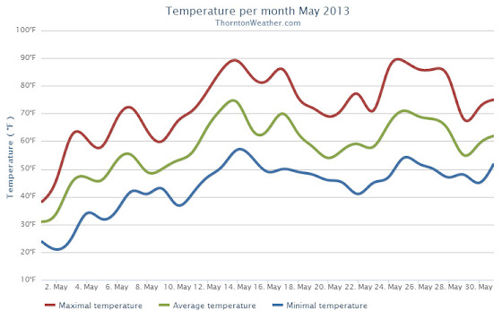
Following on colder and wetter than normal weather in previous months, Thornton’s May returned us to drier and warmer than normal conditions.
The month started out with a bit of a wintry blast of cold temperatures and snow. In fact, Denver even set an all-time May low temperature on the 2nd of the month.
The cold and snow that started the month were probably overall the most notable feature of the month. The rest of May was not particularly extraordinary in any aspect.
Denver’s average temperature for the month was 57.9 degrees. This was 0.8 degrees above average. Here in Thornton we were just slightly cooler with an average temperature of 57.6 degrees.
Thornton’s temperatures ranged from a high of 89.2 degrees on the 14th down to a low of 20.7 degrees on the morning of the 2nd. Denver saw a maximum temperature of 88 and a low of 19 degrees.
Official Denver temperature records for the month included:
DAILY RECORDS:
DATE TEMPERATURE TYPE OF RECORD OLD RECORD YEAR LAST SET
MAY 2ND 19 DEGREES RECORD LOW 22 DEGREES 1954
MAY 14TH 87 DEGREES TIED RECORD HIGH 87 DEGREES 1996
MONTHLY RECORDS:
DATE TEMPERATURE TYPE OF RECORD OLD RECORD YEAR LAST SET
MAY 2ND 19 DEGREES TIED RECORD LOW 19 DEGREES MAY 3RD 1907
In terms of precipitation, Denver recorded only 0.82 inches, far below the average for May of 2.12 inches. Here in Thornton Mother Nature was far more generous as we recorded 2.35 inches.
The snow that started the month totaled 4.3 inches in Thornton, 3.4 inches in Denver. Both were well above the May average of 1.1 inches snowfall.
May 19 to May 25: This Week in Denver Weather History
Severe weather takes to the forefront in our look back at this week in Denver weather history. We see many historical flooding events that were commonplace in the late 19th / early 20th century before controls were put in place. Almost everyone will recall the Windsor tornado, an EF3 monster that struck the town five years ago.
From the National Weather Service:
18-19
In 2011…a severe thunderstorm in central Adams County produced large hail and heavy rainfall on the 18th. Large hail from 1 inch to 1 3/4 inches in diameter…was reported in Commerce City…2 miles south-southeast of federal heights…Northglenn…and 2 miles south of Thornton.
In Commerce City…the storm uprooted trees and knocked out power lines. A carport was lifted off the ground and struck the power lines overhead. Heavy rain…from 1.0 to 1.5 inches fell in less than 2 hours in Commerce City and near Brighton. The combination of hail and strong winds broke windows in Northglenn.
In the foothills…moderate to heavy snow showers developed overnight. Storm totals included: 10.5 inches at Gold Hill…9.5 inches…3 miles west of Jamestown; 9 inches at Lake Eldora; with 6 inches… 11 miles southwest of Gilpin and 4 miles east-northeast of Nederland. At Denver International Airport…total rainfall over the 2-day period totaled 1.71 inches.
In addition…a peak wind gust to 37 mph was recorded on the 18th.
18-20
In 1915…3.9 inches of snow fell in the city. The estimated amount of snow that melted as it fell was 6.2 inches which would have totaled an estimated 10.1 inches of snowfall. Precipitation totaled 1.03 inches. North winds were sustained to 32 mph on the 18th. Low temperatures dipped to 25 degrees on both the 18th and 20th…establishing record minimums for both dates.
In 1988…prolonged heavy rainfall drenched metro Denver. The event began when heavy thunderstorms on the 18th caused some street flooding and power outages…followed by steady rain on the 19th and 20th. Rain amounts across metro Denver totaled 3 to 4 inches. Rainfall totaled 3.71 inches at Stapleton International Airport where north winds gusted to 39 mph on the 20th. Four to eight inches of snow fell in the foothills above 7 thousand feet.
19
In 1927…southeast winds were sustained to 40 mph with gusts to 44 mph.
In 1956…a thunderstorm wind gust to 54 mph was recorded at Stapleton International Airport.
In 1969…hail stones to 1 inch in diameter were measured in Arvada and Aurora. Some minor damage was reported. Pea to marble size hail fell in Westminster.
In 1972…a tornado was reported by aircraft about 5 to 10 miles east of Parker.
In 1988…lightning started a fire at a house in the Denver suburb of greenwood village…causing 2 thousand dollars in damage.
In 1991…strong thunderstorms over east metro Denver produced wind gusts of 56 to 60 mph. The strong winds downed power lines…trees…and fences at some locations in Aurora. Thunderstorm outflow winds gusted to 60 mph at Stapleton International Airport.
In 1994…severe thunderstorms rumbled across metro Denver. The storms produced wind gusts averaging 65 mph and hail up to dime size. Wind gusts to 77 mph were recorded in Brighton. Numerous trees and power poles were downed by the winds. One power pole fell onto spectators at a high school graduation ceremony in Commerce City…injuring 6 people. In Fort Lupton…trees fell onto 2 parked cars… Knocking out the windshields. Hail to 3/4 inch in diameter was reported in Littleton. A thunderstorm wind gust to 52 mph was recorded at Stapleton International Airport.
In 1995…a slow moving tornado…which was mainly discernible by its dust and debris cloud…was spotted 2 miles northeast of Denver International Airport or about 10 miles northwest of Bennett. No damage was reported.
In 2007…lightning struck a 33-ft statue of Jesus at Mother Cabrini Shrine…in the foothills west of Golden. The blast broke off one of the statue’s arms and a hand…and also damaged a foot. It cost an estimated $200000 to repair.
In 2009…lightning struck the roof of a residence in Highlands Ranch. The home was not a total loss…but the fire caused extensive damage.
In 2010…a thunderstorm produced hail up to 7/8 inch in diameter in Thornton.
19-20
In 1864…a devastating major flash flood occurred on the normally dry and sandy Cherry Creek in Denver. The flood was caused by heavy thunderstorm rainfall and hail over the palmer ridge to the south of the city in both the Cherry Creek and plum creek basins. Nineteen deaths occurred along the South Platte River and Cherry Creek in Denver. The torrent swept cattle and sheep along with large trees and houses before it washing out several bridges…and moving large structures from their foundations. All city records were destroyed when city hall washed away. The rocky mountain news building…built on stilts in the middle of the creek…was totally destroyed by the raging waters…which were as deep as 5 feet on the morning of the 20th. Once the flood waters receded…much sand and gravel was left behind. Property damage from the flood was estimated at nearly one million dollars. This was the first major flood of record in the city.
May 12 to May 18: This Week in Denver Weather History
The snow is gone – almost – but as our look back at this week in Denver weather history shows, it could return. That however is unlikely and more typical spring severe weather is far more common.
From the National Weather Service:
10-12
In 2011…a spring snowstorm brought heavy snow to the Front Range foothills and Palmer Divide. Storm totals included: 18 inches…4 miles south-southeast of Pinecliffe; 16 inches in Coal Creek Canyon; 15 inches…4 miles west-southwest of Eldorado Springs; 13 inches at Gold Hill…12 inches…4 miles west-southwest of Conifer and 4 miles northwest of Elizabeth; 11.5 inches…6 miles southwest of Evergreen and 4 miles east-northeast of Nederland; 11 inches…3 miles east of Jamestown and 10.5 inches…3 miles east of Franktown and 3 miles south of Golden and 10 inches…10 miles north of Elizabeth. At Denver International Airport… 1 inch of snowfall was observed.
12
In 1875…two forest fires on the eastern slope of the foothills were visible from the city.
In 1904…north winds were sustained to 40 mph with gusts to 48 mph.
In 1950…brilliant and complete primary and secondary rainbows arching across the sky were observed from Stapleton Airport.
In 1951…a wind gust to 51 mph was recorded at Stapleton Airport.
In 1984…winds gusted to 69 mph in Boulder. Northwest winds gusted to 47 mph at Stapleton International Airport.
In 1987…a small weak tornado touched down for about 2 minutes in southeast Denver. The twister hit a car dealership…blowing about a dozen windows out of cars and shattering four skylights on the building. Some tin roofing was blown off a patio a block and a half away. The tornado also downed a power pole. Damage at the dealership was estimated at 10 thousand dollars. A man was slightly injured by lightning in northwest Aurora.
In 1995…several funnel clouds were sighted near Parker. One of the funnels produced a short-lived debris cloud on the ground in an open field. No damage was reported.
12-13
In 1907…the temperature warmed to a high of 73 degrees on the 12th…before a cold front produced a thunderstorm… Northeast winds sustained to 40 mph…and rain changing to light snow overnight. Snowfall totaled only 2 inches…but the high temperature on the 13th was only 39 degrees.
In 1961…a storm that covered metro Denver with rain and snow started as thunderstorms on the evening of the 12th. Hail to 1 1/2 inches in diameter was reported 10 miles northwest of Stapleton Airport. Rain continued overnight and changed to snow on the 13th. Snowfall totaled 6.4 inches and precipitation (rain and melted snow) 1.96 inches at Stapleton Airport where north winds gusted to 39 mph. The rain and heavy wet snow caused icing damage to utility lines. Heavy snow occurred in the foothills.
In 1982…a major storm dumped 1.50 to 3.50 inches of rain across northeast Colorado and deposited prodigious amounts of snow in the foothills. Coal Creek Canyon southwest of Boulder was buried under 46 inches of snow with 39 inches at Nederland. The heavy wet snow downed many power lines in the foothills. In Thornton…the roof of a school was damaged by water from the heavy rain. At Stapleton International Airport…1.49 inches of rain were measured over the two day period. The heavy rain ended a severe and prolonged drought.
In 2004…a winter storm produced heavy snow in excess of a foot in the foothills above 6 thousand feet while heavy rain fell across the city. The heaviest snow occurred in the high country of Boulder County. Storm total snowfall was 14.5 inches near Jamestown. Rainfall totaled 0.81 inch at Denver International Airport with 0.94 inch recorded at Denver Stapleton. A trace of snow was recorded at both locations. East winds gusted to 24 mph at Denver International Airport on the 12th.
13
In 1905…a thunderstorm produced hail during the late afternoon. Precipitation totaled 0.57 inch.
13-14
In 1912…heavy snowfall totaled 12.4 inches over the city. Most of the snow…9.9 inches…fell on the 13th…which was the greatest 24 hour snowfall in May at the time. This was the last snowfall of the season. The low temperature dipped to 27 degrees on the morning of the 14th.
In 1989…a spring storm brought heavy rain and snow to the foothills. Metro Denver was soaked with 1 to 2 inches of rain. Rainfall totaled 1.26 inches at Stapleton International Airport.
In the foothills…Echo Lake received 20 inches of snow. A 30-ton Boulder slid onto I-70 east of the Eisenhower Tunnel…closing the freeway for 2 hours.
May 5 to May 11: This Week in Denver Weather History
This time of year the focus is usually on spring severe weather with lightning, tornadoes and hail being the highlight. Our look back at this week in Denver weather history shows many of those types of events. Also notable are the few, unusually late in the season snow events, some of which were quite heavy.
From the National Weather Service:
1-5
In 1898…snowfall totaled 15.5 inches in downtown Denver. Most of the snow…6.2 inches…fell on the 3rd. Most of the snow melted as it fell. The greatest snow depth on the ground was only 2.5 inches on the 3rd at 8:00 pm. This was the only snowfall during the month. Northeast winds were sustained to 22 mph on the 1st.
2-5
In 2001…a very slow moving pacific storm system became parked near the four corners region…which allowed heavy snow to develop above 6500 feet in the foothills with a mix of rain and snow over lower elevations of metro Denver. Snowfall totals included: 21 inches atop Crow Hill and at Idaho Springs; 19 inches near Blackhawk; and 18 inches in Coal Creek Canyon…Genesee…and 11 miles southwest of Morrison. Snowfall totaled 6.2 inches at the site of the former Stapleton International Airport. Precipitation (rain and melted snow) totaled 2.09 inches at Denver International Airport where north winds gusted to 30 mph on the 2nd.
3-5
In 1908…rain changed to snow on the evening of the 3rd and continued through the early evening of the 5th. Snowfall totaled 10.0 inches over downtown Denver. This was the last measurable snow of the season. Precipitation totaled 1.51 inches. North winds were sustained to 23 mph on the 3rd…33 mph on the 4th…and 21 mph on the 5th. Three temperature records were set. High temperatures of 30 degrees on the 4th and 38 degrees on the 5th were record low maximum temperatures for the dates. The reading on the 4th was also the all-time record low maximum for the month of May.
In 2007…a slow moving pacific storm system…from the desert southwest…brought a period of unsettled weather to the region. During the 3-day period…locally heavy snow was reported over parts of the Front Range foothills. Storm totals included: 15 inches near Conifer…14.5 inches west of Jamestown…13.5 inches; 6 miles southwest of Evergreen…and 12.5 inches at pine junction. Severe thunderstorms…producing large hail…up to one inch in diameter were observed in the vicinity of Boulder and Hudson. Lightning struck a residence in Jefferson County. The roof was hit…causing the attic to catch fire. At Denver International Airport…lightning struck a United Airlines jet as it was pushing away from the gate. The passengers were taken off the jet and put on another plane.
4-5
In 1986…high winds buffeted the foothills. Wind speeds of 60 to 75 mph were recorded in Boulder. At Stapleton International Airport…west winds gusted to 45 mph on the 4th and to 40 mph on the 5th.
In 2000…a brief warm spell resulted in setting two daily high temperature records. The temperature climbed to highs of 87 degrees on the 4th and 89 degrees on the 5th.
4-8
In 1969…heavy rains caused flooding on Boulder creek in Boulder…which resulted in one death on the 7th. Flooding also occurred on bear creek in Sheridan and on the South Platte River in Denver. Rain over most of the eastern foothills started late on the 4th and continued with only brief interruptions in many areas until the morning of the 8th. Very high rates of rainfall occurred on the 6th and 7th with the greatest intensities in a band along the foothills from about 25 miles southwest of Denver northward to Estes Park. Storm totals by both official and unofficial measurements exceeded 10 inches over much of this area and were over 12 inches in some localities. Heavy snow fell in the higher mountains and in the foothills later in the period. The saturation of the soil resulted in numerous rock and landslides…and the heavy run-off caused severe damage along many streams and flooding on the South Platte River. Many foothill communities were isolated as highways were blocked and communications disrupted. Roads were severely damaged over a wide area…and a large number of bridges washed out. Many roads were closed due to the danger from falling rocks. A building in Georgetown collapsed from the weight of heavy wet snow. In Boulder…a man drowned when caught by the flooding waters of Boulder Creek…and a patrolman was injured. Rainfall totaled 7.60 inches in Boulder with 9.34 inches recorded at the Public Service Company electric plant in Boulder Canyon. In Morrison…rainfall totaled 11.27 inches in 4 days. Heavy rainfall totaled 4.68 inches at Stapleton International Airport over 3 days from the 5th through the 7th. Rainfall of 3.14 inches was recorded in 24 hours on the 6th and 7th. Downstream flooding continued along the South Platte River until the 12th when the flood crest reached the Nebraska line.
5
In 1903…apparent post-frontal northeast winds were sustained to 48 mph with gusts to 60 mph.
In 1950…a northwest wind gust to 52 mph was recorded at Stapleton Airport.
In 1969…a funnel cloud was observed for 2 to 3 minutes just north of Parker. Two other funnel clouds were sighted in the same area. The public sighted a tornado 15 miles east of Stapleton International Airport. No damage was reported.
5-6
In 1907…rain changed to snow on the 5th…continued through the night…and totaled 3.50 inches. Northeast winds were sustained to 15 mph on the 5th.
In 1917…post-frontal rain changed to heavy snow and totaled 12.5 inches over downtown Denver. Most of the snow… 12.0 inches…fell on the 5th and this was the greatest 24-hour snowfall ever measured during the month of May. This was also the only measurable snow of the month that year. Low temperatures of 27 degrees on the 5th and 23 degrees on the 6th were record minimums for the dates. High temperatures on both days were in the lower 40’s. Southeast winds were sustained to 24 mph with an extreme velocity to 26 mph.
In 1964…high winds gusted to 54 mph in Boulder and to 80 mph at Jefferson County Airport near Broomfield. Wind gusts of 50 to 60 mph were common over all of eastern Colorado. Buildings…power lines…trees…and vehicles were damaged by the wind. South-southwest wind gusts to 54 mph caused some blowing dust at Stapleton International Airport where the visibility was briefly reduced to 2 miles.
In 1973…a heavy driving rain storm with embedded thunderstorms…produced 1 to 5 inches of rain and caused local flash flooding along the east slopes of the Front Range. The greatest flash flooding occurred in metro Denver where rainfall totaled 3.56 inches at Stapleton International Airport. Flooding in metro Denver occurred on Clear Creek and the South Platte River…already swollen from heavy snowmelt. Numerous basements were flooded… Roads and streets were washed out…a bridge was demolished… And miscellaneous other damage was reported. North winds gusted to 39 mph at Stapleton International Airport during the storm. The storm produced major downstream flooding along the South Platte River all the way to the Nebraska border during the next two weeks. One person died and total damage was estimated at around 120 million dollars.
In 1978…heavy wet snow of around 24 inches collapsed an office and hotel building in Boulder. Many cars were abandoned in the city. Denver received 14 inches of heavy wet snow with Evergreen and Golden reporting 12 inches. Snowfall totaled 12.4 inches at Stapleton International Airport with a total accumulation of snow on the ground of 8 inches due to melting. Southeast winds gusted to 23 mph on the 5th. Temperatures both days remained in the lower to mid-30’s.
Denver’s recent cold continued as this morning one low temperature record was broken, another tied.
In the wake of our May Day snowstorm, clear skies the following morning allowed temperatures to plummet and reach very winter-like levels. As the mercury bottomed out, Denver broke one low temperature record and tied another.
As measured at Denver International Airport, the temperature this morning dropped to 19 degrees at 6:41am. This easily breaks the previous record low temperature for May 2 of 22 degrees set in 1954.
Most notably, the 19 degree reading also tied the record for the lowest temperature ever recorded during the month of May since record keeping began in Denver in 1872. We have to go all the way back to May 3, 1907 to find a reading that low during May.
Here in Thornton we were quite cold as well although not quite as much as DIA. Our morning low temperature of 20.7 degrees was seen at 6:00am.
The cold and snowy start to May mimics what was seen during the month of April. Last month Denver recorded its fifth coldest and 11th snowiest April on record.
Colorado’s famously highly variable weather seems to showcase itself during the month of May when a variety of weather conditions can be seen.
Winter-like temperatures and snow are possible as are mid-summer like temperatures or the more typical spring severe weather.
As the month starts out in 2013 we are going to receive a wintry blast with cold and snow. This is not entirely unusual as Denver averages 1.7 inches of snow during the month since records began.
More common however is severe weather, particularly in the latter half of the month. Thunderstorms become more frequent and their associated hazards – lightning, wind, hail and tornadoes – are usual visitors.
April 28 to May 4: This Week in Denver Weather History
As we begin to enter the month of May, Denver’s weather starts to make the move toward spring severe weather and snow becomes less common. Looking back at this week in Denver weather history, there has been some snow but lightning and hail are more typical of the types of extreme weather we would expect to see.
From the National Weather Service:
27-28
In 1919…rainfall totaled 2.03 inches for the two days… Along with a trace of snowfall. Northwest winds were sustained to 24 mph with gusts to 26 mph on the 27th.
In 1975…high winds gusting to 85 mph severely damaged a mobile home in Boulder and caused other minor damage. West winds gusted to 46 mph at Stapleton International Airport on the 28th.
In 1996…heavy snow fell over portions of the Front Range foothills west of Denver. Snowfall amounts ranged from 4 to 7 inches. Only 0.3 inch of snow fell at the site of the former Stapleton International Airport. North winds gusted to 41 mph at Denver International Airport on the 27th.
28
In 1894…southwest winds were sustained to 35 mph with gusts as high as 60 mph.
In 1896…apparent post-frontal bora winds from the northwest were sustained to 43 mph with gusts as high as 56 mph. Rainfall totaled 0.22 inch.
In 1990…high winds raked the northeastern plains and eastern foothills from Boulder north. Wind gusts to 70 mph were recorded in Boulder. West winds gusted to 41 mph at Stapleton International Airport.
In 2001…a 21-year-old man was struck by lightning along the shoulder of I-225 near Parker road. His brother’s car had broken down and he stopped to help. The bolt briefly stopped the man’s heart and caused the right side of his body to go numb.
In 2003…severe thunderstorms produced large hail across southern metro Denver. Hail to 1 3/4 inches in diameter fell in Englewood and 2 miles east of Centennial Airport. Hail as large as 1 1/2 inches in diameter fell in Aurora near Cherry Creek. Other large hail reports included 1 inch hail near Bennett…and 7/8 inch hail in greenwood village and at centennial airport.
28-29
In 1950…snowfall totaled 6.3 inches at Stapleton Airport…but only 3.5 inches over downtown Denver.
In 1960…heavy snow fell at Stapleton Airport where 8.6 inches of snow were measured. North winds gusted to 38 mph. Most of the snow…6.9 inches…fell on the 29th.
29
In 1898…apparent thunderstorm winds were sustained from the southwest to 58 mph with gusts to 66 mph.
In 1909…north winds were sustained to 44 mph behind an apparent cold front. These were the strongest measured winds of the month that year.
In 1962…heavy snowfall totaled 6.4 inches at Stapleton Airport where northeast winds gusted to only 17 mph. Snow fell all day…but the most on the ground was only 1 inch due to melting.
In 1991…two men were struck by lightning while golfing in Cherry Hills just south of Denver. The two received only minor burns. Shortly afterward…lightning struck a home in cherry hills village several times…leaving numerous holes in the roof. No injuries were reported.
In 1993…localized strong winds occurred at Jefferson County Airport near Broomfield where gusts to 63 mph were recorded. The strong winds were the result of a probable microburst.
In 2000…several severe thunderstorms producing large hail and destructive winds rumbled across northern metro Denver. Thunderstorm wind gusts reached 81 mph near Hudson with hail as large as 3/4 inch in diameter at Longmont. Several homes and vehicles sustained damage. The strong winds uprooted trees and downed utility poles…causing scattered outages. Lightning sparked a house fire in Boulder. The fire damaged a portion of the roof and a bedroom on the third floor. Thunderstorm winds gusted to 53 mph at Denver International Airport.
In 2003…lightning struck a chimney at a residence in Hiwan in Evergreen…sending stones flying as far as 150 feet. Electrical equipment in some nearby homes also failed. Damage to the residence…in addition to electrical equipment…was estimated at 100 thousand dollars. Severe thunderstorms produced large hail to 1 inch in diameter near Hudson and Sedalia and to 3/4 inch near Parker. Hail as large as 1 3/4 inches was measured 9 miles north of Sedalia.
May 27 to June 2 - This Week in Denver Weather History
A very eventful week in Denver weather history with everything from thunderstorms and tornadoes to yes, even snow.
From the National Weather Service:
20-27
In 2002…lightning sparked a wildfire near Deckers. Extremely dry conditions and very strong winds the following day allowed the fire…known as the Schoonover…to consume 3850 acres before it could be contained. Thirteen structures were destroyed…including 4 homes…resulting in 2.2 million dollars in damage.
26-31
In 1995…a cool period with light morning showers and moderate to heavy afternoon showers and thunderstorms pushed rivers already swollen from mountain snow melt over their banks causing minor flooding. Streams and rivers such as the South Platte and Boulder Creek flooded meadowlands…bike paths…roads near streams…and other low lying areas. No significant property damage was reported and crop damage was unknown. Rainfall totaled 1.79 inches at the site of the former Stapleton International Airport and only 1.51 inches at Denver International Airport.
27
In 1874…an apparent thunderstorm gust front reached the city at 6:40 pm. Strong southwest winds sustained to 48 mph for a few minutes produced large columns of dust in the city and on the prairie. There was no rain in the city.
In 1942…a duststorm swept into the city…but no damage was reported. West winds were sustained to 23 mph.
In 1953…a heavy hailstorm caused an estimated 100 thousand dollars damage across metro Denver. Larger than golf ball size hail fell in Westminster and north Denver. Only 1/8 inch hail was measured at Stapleton Airport.
In 1955…west-northwest winds at 35 mph with gusts as high as 58 mph briefly reduced the visibility to 1/2 mile in blowing dust at Stapleton Airport.
In 1981…lightning damaged power lines west of Lakewood and blew up a transformer at the Denver Federal Center. Hail 1 to 1 1/2 inches in diameter was reported in Lakewood and on I-25 south of Denver.
In 2001…hail as large as 3/4 inch in diameter was measured near Commerce City.
In 2003…hail to 3/4 inch in diameter fell near Central City.
In 2006…unusually warm weather for late May produced two temperature records. The high temperature of 93 degrees was a record maximum for the date. The low temperature of 59 degrees equaled the record high minimum temperature for the date. Both previous records occurred in 1895.
May 20 to May 26 - This Week in Denver Weather History
This week marks the four year anniversary of the infamous Windsor tornado but it is not the only noteworthy weather event to have occurred during this week in Denver weather history.
From the National Weather Service:
18-20
In 1915…3.9 inches of snow fell in the city. The estimated amount of snow that melted as it fell was 6.2 inches which would have totaled an estimated 10.1 inches of snowfall. Precipitation totaled 1.03 inches. North winds were sustained to 32 mph on the 18th. Low temperatures dipped to 25 degrees on both the 18th and 20th…establishing record minimums for both dates.
In 1988…prolonged heavy rainfall drenched metro Denver. The event began when heavy thunderstorms on the 18th caused some street flooding and power outages…followed by steady rain on the 19th and 20th. Rain amounts across metro Denver totaled 3 to 4 inches. Rainfall totaled 3.71 inches at Stapleton International Airport where north winds gusted to 39 mph on the 20th. Four to eight inches of snow fell in the foothills above 7 thousand feet.
19-20
In 1864…a devastating major flash flood occurred on the normally dry and sandy Cherry Creek in Denver. The flood was caused by heavy thunderstorm rainfall and hail over the palmer ridge to the south of the city in both the Cherry Creek and plum creek basins. Nineteen deaths occurred along the South Platte River and Cherry Creek in Denver. The torrent swept cattle and sheep along with large trees and houses before it washing out several bridges…and moving large structures from their foundations. All city records were destroyed when city hall washed away. The Rocky Mountain News building…built on stilts in the middle of the creek…was totally destroyed by the raging waters…which were as deep as 5 feet on the morning of the 20th. Once the flood waters receded…much sand and gravel was left behind. Property damage from the flood was estimated at nearly one million dollars. This was the first major flood of record in the city.
20
In 1874…after a light late afternoon shower…3 rainbows were visible in the eastern sky. The two upper bows were of the usual colors. The lower bow had a deep violet center with a faint yellow and white rim.
In 1892…apparent post-frontal north winds were sustained to 40 mph with gusts to 48 mph. A trace of snow was the last snowfall of the season.
In 1899…snow pellets from 1/4 to 3/8 inch in diameter fell from a thundershower during the late afternoon. West winds were sustained to 42 mph with gusts as high as 48 mph.
In 1904…southeast winds were sustained to 40 mph with an extreme velocity of 42 mph produced by a thunderstorm.
In 1961…a tornado tore through central Douglas County…1 1/2 miles north of Castle Rock. The storm struck 2 ranches and the property of a drilling company. A car on the highway was lifted off the road and slammed into a truck…injuring the two occupants.
In 1983…heavy rain fell in Aurora with 1.00 to 1.50 inches of precipitation. Local flooding occurred in Lakewood.
In 1990…1 inch diameter hail fell at Buckley Field in Aurora. Minor damage was reported to autos…buildings and signs.
In 1995…hail as large as 3/4 inch in diameter fell near Bennett where a funnel cloud was sighted.
In 2001…damaging winds developed behind a vigorous cold front that moved south from Wyoming into metro Denver. High winds…gusting to 58 mph at Denver International Airport…downed trees and power lines and kicked up blowing dust…dirt…and debris…reducing the visibility to near zero at times. The poor visibility caused a multi-vehicle accident along U.S. Highway 85 north of Fort Lupton. Six people were treated for minor injuries. Several vehicles… Including semi-trailers…were blown off I-70 east of Denver. About 32 thousand Xcel Energy customers in metro Denver were without electricity for up to 2 hours. At least a dozen incoming flights at Denver International Airport were diverted to other airports. All departing flights were grounded for at least an hour. At Southwest Plaza…shoppers were evacuated as rocks holding a tarp on a portion of a roof under repair toppled into the mall. After the passage of the cold front…temperatures plunged from the lower 70’s to the mid 30’s in one hour as light snow developed. Heavy snow developed in the foothills during the evening. Peak wind reports included 68 mph near Parker and 63 mph near Sedalia. Snowfall totals included: 7 inches near Blackhawk… At Ken Caryl Ranch…and near Sedalia; 6 inches in Coal Creek Canyon…at Eldorado Springs…and atop Lookout Mountain; 5 inches at Chief Hosa…in Louisville…Rollinsville…and Wheat Ridge; and 4 inches in Aurora…Bailey…Parker…Castle Rock and near Morrison. Low temperature of 31 degrees during the early morning of the 21st equaled the record low for the date last set in 1931.
In 2004…severe thunderstorms produced hail as large as 1.25 inches near Ft. Lupton and hail to 1.50 inches 10 miles north of Ft. Lupton.
May 13 to May 19 - This Week in Denver Weather History
As we get further into spring the chances for severe weather increase greatly across northeastern Colorado and that is seen in our look back at this week in Denver weather history. We also note the dangers this weather presents as we see events where the weather injured and even killed Coloradoans.
From the National Weather Service:
12-13
In 1907…the temperature warmed to a high of 73 degrees on the 12th…before a cold front produced a thunderstorm… Northeast winds sustained to 40 mph…and rain changing to light snow overnight. Snowfall totaled only 2 inches…but the high temperature on the 13th was only 39 degrees.
In 1961…a storm that covered metro Denver with rain and snow started as thunderstorms on the evening of the 12th. Hail to 1 1/2 inches in diameter was reported 10 miles northwest of Stapleton Airport. Rain continued overnight and changed to snow on the 13th. Snowfall totaled 6.4 inches and precipitation (rain and melted snow) 1.96 inches at Stapleton Airport where north winds gusted to 39 mph. The rain and heavy wet snow caused icing damage to utility lines. Heavy snow occurred in the foothills.
In 1982…a major storm dumped 1.50 to 3.50 inches of rain across northeast Colorado and deposited prodigious amounts of snow in the foothills. Coal Creek Canyon southwest of Boulder was buried under 46 inches of snow with 39 inches at Nederland. The heavy wet snow downed many powerlines in the foothills. In Thornton…the roof of a school was damaged by water from the heavy rain. At Stapleton International Airport…1.49 inches of rain were measured over the two day period. The heavy rain ended a severe and prolonged drought.
In 2004…a winter storm produced heavy snow in excess of a foot in the foothills above 6 thousand feet while heavy rain fell across the city. The heaviest snow occurred in the high country of Boulder County. Storm total snowfall was 14.5 inches near Jamestown. Rainfall totaled 0.81 inch at Denver International Airport with 0.94 inch recorded at Denver Stapleton. A trace of snow was recorded at both locations. East winds gusted to 24 mph at Denver International Airport on the 12th.
13
In 1905…a thunderstorm produced hail during the late afternoon. Precipitation totaled 0.57 inch.
13-14
In 1912…heavy snowfall totaled 12.4 inches over the city. Most of the snow…9.9 inches…fell on the 13th…which was the greatest 24 hour snowfall in May at the time. This was the last snowfall of the season. The low temperature dipped to 27 degrees on the morning of the 14th.
In 1989…a spring storm brought heavy rain and snow to the foothills. Metro Denver was soaked with 1 to 2 inches of rain. Rainfall totaled 1.26 inches at Stapleton International Airport.
In the foothills…Echo Lake received 20 inches of snow. A 30-ton Boulder slid onto I-70 east of the Eisenhower Tunnel…closing the freeway for 2 hours.
14
In 1910…a thunderstorm produced strong winds during the afternoon. Northwest winds were sustained to 42 mph.
In 1913…light moist snow and light hail fell during short intervals…although no thunder was heard. The trace of snowfall was the only snow of the month. Precipitation… Mostly rain…totaled 0.44 inch.
In 1984…a pilot reported a tornado 16 miles east of Stapleton International Airport. No damage was reported. A thunderstorm produced a 58 mph wind gust in Brighton. Thunderstorm winds gusted to 48 mph at Stapleton International Airport.
In 1989…lightning struck a home in Evergreen…setting it afire.
In 1992…strong thunderstorm winds of unknown velocity… Knocked over and damaged the infield tote board at Arapahoe Park Racetrack just southeast of Aurora. Damage was estimated at 200 thousand dollars. No injuries were reported. Lightning started two house fires…causing 35 hundred dollars in damage in Adams County just 9 miles north-northwest of Denver.
In 1994…a sudden wind gust…estimated at 40 mph…blew a portion of the roof off a shopping center in Lafayette. The roof also damaged two parked cars in an adjacent lot.
In 2001…a construction worker in Castle Rock received minor injuries when lightning struck close-by.
In 2002…a microburst wind gust to 53 mph was recorded at Denver International Airport.
In 2007…severe thunderstorms producing large hail…very heavy rain…and tornadoes impacted the urban corridor and adjacent plains. Heavy rain associated with a severe thunderstorm caused flooding along a small tributary draining into the South Platte River. The incident took place at 13th and Decatur St….near Invesco Field. The floodwaters inundated the bike trail adjacent to the creek. A woman with her child sought refuge under a bridge and became trapped by the high water. The woman slipped and the stroller containing the child was swept into the swift current. The child drowned. Rainfall totaled 0.42 inches at Denver International Airport. Elsewhere…golf ball hail was reported near Hudson. Hail…up to one inch in diameter…was observed in Boulder and Lyons. Thunderstorm wind gusts estimated to 70 mph were reported near Buckley Air Force Base…with a peak wind gust to 37 mph observed at Denver International Airport. A small tornado touched down near Ft. Lupton but did no damage.
14-15
In 1977…high winds up to 100 mph felled hundreds of trees in Gilpin County and caused extensive damage to telephone and power lines. Lumber and steel tanks were blown around in Boulder canyon. West winds gusted to 46 mph at Stapleton International Airport on the 15th.