Tag Archives: July Weather

July 3 to July 9: This Week in Denver Weather History

This Week In Denver Weather History
July 3 to July 9: This Week in Denver Weather History

In our July weather preview we discussed how the month is not only Denver’s hottest but also its stormiest. Our look back at this week in Denver weather history helps to illustrate that fact. We start seeing 100+ degree days as well as many of the types of fast moving thunderstorm events expected this time of year.

From the National Weather Service:

29-15

In 2000…the 29th marked the beginning of a near record hot streak for metro Denver. The high temperatures…as recorded at Denver International Airport…exceeded the 90 degree mark for 17 consecutive days from June 29th through July 15th. The record of 24 consecutive 90 degree or above days was set from July 13th through August 5th…2008.

1-18

In 1874…a streak of 18 consecutive days of 90 degrees tied for second with another streak that was later set in the summer of 1901. The record of 24 consecutive days was established in the summer of 2008.

1-31

In 2012…it was the hottest July on record in Denver since weather records began in 1872. The average temperature for the month was 78.9 degrees which was 4.7 degrees above normal. There were 27 days in which the high temperature equaled or exceeded 90 degrees…which established a new record. There were also 7 days in which the temperature equaled or exceeded 100 degrees which tied the record set in 2005.

3

In 1874…the temperature climbed to a high of 101 degrees in downtown Denver.

In 1881…the all time highest recorded daily minimum temperature of 77 degrees occurred in the city. This was also the highest daily minimum temperature ever recorded in July.

In 1885…a severe thunderstorm produced hail the size of hazel nuts…which fell with great force. A telegraph pole in west Denver was struck by lightning and shattered to pieces.

In 1955…a brief microburst wind gust to 61 mph was recorded at Stapleton Airport.

In 1960…a major hail storm caused 1.5 million dollars in damage across metro Denver. The heaviest damage occurred in south Denver…Englewood…Littleton…and Golden from wind- driven hail as large as golf balls and heavy rain which caused flooding. Winds were estimated at 60 to 70 mph. Rainfall was estimated at 2 to 3 inches. Hail accumulated 3 to 4 inches deep in some sections. Hail carried by flood waters drifted 3 to 4 feet deep. An Englewood policeman was injured when hail broke the windshield of his car. One inch of rain in 10 minutes…and heavy hail damage were reported in Parker. At some places the hail from the storm was still on the ground the next morning.

In 1967…large hail stones from 1 3/4 to 2 1/2 inches in diameter damaged cars and buildings in southwest Denver and Littleton where hail drifted to depths of 3 to 4 feet. The hail caused a great deal of damage…and streets were flooded by heavy rain over many sections of west metro Denver. At centennial race track near Littleton…a few hail stones were as large as tennis balls. Large hail broke the windshield on a Littleton police car. Golf ball to tennis ball size hail fell in the vicinity of Arapahoe road and south Broadway. One inch diameter hail fell at the intersection of orchard and south university. Golf ball size hail fell in Broomfield. Hail in Westminster was measured from 1 to 1 1/4 inches in diameter. Tornadoes were sighted by the public near Cheery Creek Reservoir… north of Commerce City…and in Arvada…but caused no reportable damage.

In 1993…high winds developed behind a strong cold front along portions of the Front Range. While the strongest winds were reported north of metro Denver…the winds blew out a half inch thick pane of glass from a vacant 9-story building. The glass landed on a parked car below. West winds gusting to 52 mph kicked up some blowing dust at Stapleton International Airport.

In 1996…lightning sparked a small fire near buffalo creek in southern Jefferson County. Only one acre burned before the fire was contained.

In 2002…heavy thunderstorm rain washed out a frontage road 6 miles north of Larkspur. The nearby mountain ranch subdivision was also flooded. Heavy rainfall in the Hayman fire burn area washed out a secondary road when debris from the runoff blocked a culvert. Hail as large as 3/4 inch fell near Keenesburg…in Castle Rock…and 7 miles to the south of Castle Rock.

In 2005…severe thunderstorms produced high winds. Wind gusts to 75 mph were measured near Longmont and to 60 mph just west of Boulder. No damage was reported.

In 2007…severe thunderstorms produced large hail in the foothills and suburbs west of Denver. Large hail from 1 to 2 inches in diameter was reported in the vicinity of Idaho Springs…Rollins and Edgewater.

In 2009…severe thunderstorms produced large hail and north and east of Denver. Hail up to one inch in diameter was observed near Erie and firestone. Hail up to 1 3/4 inches was observed 5 to 6 miles west-southwest of Byers. The golfball size hail caused extensive damage to a wheat field. In Aurora…six children received minor injuries when lightning struck a nearby tree. The injuries occurred when they were knocked down by the blast. None of the children suffered burns or appeared to have been directly hit by lightning.

In 2014…a severe thunderstorm produced large… up to 1 ½ inches in diameter…about 14 miles northwest of Golden.

4

In 1874…the temperature reached a high of 102 degrees in downtown Denver. Large forest fires in the mountains from the west-northwest to the south filled the atmosphere over the city with dense smoke.

In 1885…a thunderstorm produced sustained winds to 44 mph with gusts to 60 mph. A circus tent was tattered by the strong winds.

In 1900…a thunderstorm produced northwest winds sustained to 42 mph with gusts to 51 mph…but only 0.05 inch of rain.

In 1903…the all time lowest temperature ever recorded in July…42 degrees…occurred. The temperature also occurred on July 31…1873.

In 1910…thunderstorm winds were sustained to 42 mph from the southwest.

In 1922…thunderstorm winds were sustained to 37 mph with gusts to 48 mph.

In 1956…a thunderstorm wind gust to 54 mph was recorded at Stapleton Airport.

In 1964…several men were knocked down by a bolt of lightning while playing golf in south metro Denver. They got up and ran for cover when one of them was struck by a second bolt. He suffered burns and shock.

In 1987…a weak tornado was observed for 6 minutes…7 miles northeast of Watkins. Hail 3/4 to 1 1/4 inches in diameter fell in southeast Aurora.

In 1988…lightning struck a group of people at the Jefferson County fairgrounds. A 42-year-old woman was seriously injured and was hospitalized for 3 days. Four other people sustained minor injuries.

In 1993…strong northwest winds uprooted several trees across metro Denver. Wind gusts to 64 mph were reported at Erie north of Denver. A west wind gust to 43 mph was recorded at Stapleton International Airport.

In 1995…lightning struck and injured two people standing in a field in Arvada.

In 1998…heavy thunderstorm rain…up to 2.75 inches…and marble size hail combined to flood local roads and fields near Roggen.

In 2002…heavy thunderstorm rain in the Hayman fire burn area caused flash flooding. In Jefferson County…Gulch Road was washed out. In Douglas County…high water washed out some forest access roads as well…generally to the east of a line extending from signal butte to Deckers.

In 2010…intense thunderstorms produced torrential rainfall… In excess of 5 inches in one hour…and caused flash flooding in the vicinity of Elizabeth. Numerous County roads were washed out. The combination of heavy rain and hail made it necessary to run snow plows through town. Extensive basement flooding was also reported. Severe thunderstorms produced large hail from Aurora south to Elizabeth and Larkspur. The hail size ranged from 1 to 2 inches in diameter. A wet microburst produced 1.84 inches of rainfall at Denver International Airport. A peak wind gust to 48 mph was also observed from the northeast.

4-5

In 1875…nearly every railroad running into the city was damaged by heavy thunderstorm rains. The heavy rains washed out wooden bridges over normally dry creeks. Some trains were entirely suspended. In the city…heavy thunderstorm rain totaled 1.05 inches on the 4th…but only 0.28 inch on the 5th.

4-8

In 1989…one of the most intense heat waves on record roasted metro Denver. The temperature reached 100 degrees or more on 5 consecutive days. The city had previously never recorded more than 2 straight 100-degree days since records began in 1872. Water and electricity usage reached all time highs. The heat wave created extremely dry weather conditions…which contributed to a major forest fire in Boulder canyon on July 9th. The temperature reached 103 degrees on the 8th…and the mercury climbed to 101 degrees on both the 4th and 5th…and to 102 degrees on both the 6th and 7th. The low temperature of 68 degrees on the 8th equaled the record high minimum for the date.

Continue reading July 3 to July 9: This Week in Denver Weather History
June 26 to July 2: This Week in Denver Weather History
This Week In Denver Weather History
June 26 to July 2: This Week in Denver Weather History
Our look back at this week in Denver weather history certainly has plenty of the usual suspects related to severe weather. Most notable however are the many occurrences of lightning strikes and the effects they can have from sparking fires to causing significant injury and death.

From the National Weather Service:

25-26

In 1969…high winds raked Boulder causing one fatality and some injuries. One man was injured by a falling tree limb. At the National Center for Atmospheric Research in Boulder… Sustained winds of 55 to 60 mph with wind gusts to 123 mph were recorded. In downtown Boulder…winds averaged 30 to 40 mph with gusts to 70 mph. Widespread minor damage occurred… Especially in the Table Mesa area of south Boulder. Much tree damage occurred in the older areas of Boulder where several trees were uprooted. A mobile home was overturned by the winds. At Stapleton Airport…west winds gusted to 43 mph on the 25th and 37 mph on the 26th.

In 1975…strong winds damaged utility lines…buildings… vehicles…trees…and power lines in Boulder and other communities to the north of Boulder. Microburst winds gusted to 45 mph at Stapleton International Airport on the 25th.

In 1983…heavy rain fell in the foothills west of Denver with 1.50 inches in 30 minutes at Intercanyon. Heavy rain continued over metro Denver on the 26th with two-day storm totals at many locations ranging from 1.00 to 2.50 inches. Rainfall totaled 1.37 inches at Stapleton International Airport on the 26th.

In 1985…one to two inches of rain fell over metro Denver. At Stapleton International Airport…rainfall totaled 0.93 inches…thunderstorm winds gusted to 44 mph…and 7/10 inch hail was measured. The air mass was unusually cold for the season…and snow fell in the foothills above 8 thousand feet. The high temperature of only 63 degrees on the 26th equaled the record low maximum reading for the date.

26

In 1873…there was a great deal of smoke from a large forest fire in the mountains to the southwest of the city and a smaller fire directly to the west.

In 1874…fires at timberline to the west were visible from the city. New and extensive fires were continually started from south to northwest along the ridge line. Carelessness of tourists was the apparent cause of the fires. Large and valuable tracts of timber had already been destroyed.

In 1890…the only thunderstorm of the month produced a trace of rain. A trace of rain also fell on 7 other days. This was the only precipitation recorded during the month… Making it the driest June on record.

In 1893…northwest winds were sustained to 45 mph with gusts to 48 mph.

In 1971…a microburst wind gust to 58 mph was recorded at Stapleton International Airport. Dust devils were sighted.

In 1980…strong gusty thunderstorm winds damaged several mobile homes in Thornton. Thunderstorm winds gusted to 37 mph at Stapleton International Airport.

In 1986…hail piled up 1 1/2 inches deep in Golden Gate Canyon and covered roadways an inch deep in Evergreen.

In 1988…a tornado touched down 2 miles north of Watkins. It was on the ground for 15 minutes and did no reported damage.

In 1989…two inch diameter hail fell at Kassler…1 inch hail at Louviers…and 1 1/2 inch hail at tiny town.

In 1991…high winds…not associated with thunderstorms… Damaged a home in the Green Mountain area. The strong winds picked up a heavy metal and glass table on the deck of a house and threw it into the house. The table was destroyed and the house received considerable damage.

In 1992…3/4 inch diameter hail fell in south Aurora and near Buckley Air National Guard base. Golf ball size hail was reported in Parker.

In 1994…the all-time highest recorded temperature in June and the second highest temperature ever recorded in Denver… 104 degrees occurred. This was the hottest day in Denver since August 8…1878…when the temperature reached 105 degrees.

In 2005…strong thunderstorm winds gusting to 58 mph damaged a garage and some nearby trees near Fort Lupton. Winds also gusted to 58 mph near Watkins. Thunderstorm winds gusted to 60 mph near Roggen. Hail to 3/4 inch in diameter was measured in southwest Aurora.

In 2009…severe thunderstorms moving through Denver and the surrounding metro area produced intense thunderstorm winds. At Denver International Airport…a wind gust blew a luggage car into a southwest airlines airplane causing some damage. Peak wind gusts included: 68 mph at Denver International Airport…4 miles west of rocky mountain metropolitan airport and 12.5 miles north of Lowry AFB; 64 mph near Arvada and Parker; and 60 mph in Aurora/cherry.

26-27

In 1965…wind gusts to 38 mph were recorded in downtown Boulder…causing widespread minor damage. A microburst wind gust to 41 mph was recorded at Stapleton International Airport.

27

In 1873…Pikes Peak was hidden from view by smoke from forest fires in the mountains to the southwest of the city.

In 1927…the temperature cooled to a low of only 72 degrees… The all-time record high minimum for the month.

In 1980…lightning injured 4 people on a baseball diamond in Broomfield. The bolt seriously injured the pitcher while also striking (out) the batter…catcher and second baseman.

In 1987…a microburst wind gust to 53 mph was recorded at Stapleton International Airport.

In 1990…the temperature reached a high of 102 degrees… Setting a new record maximum for the date.

In 1993…thunderstorm winds gusted to 60 mph across parts of metro Denver. A wind gust to 50 mph blew over a 30-foot canvas tent at an amusement park southeast of Denver. Fifteen people…mostly children…were injured. Microburst wind gusts to 33 mph were recorded at Stapleton International Airport.

In 2002…heavy rain…up to 3/4 inch…fell across sections of the Hayman burn area near Cheeseman Reservoir. Several forest service roads were washed out and many culverts were plugged by debris.

In 2004…heavy rain producing thunderstorms caused rock and mud slides across the overland fire burn area in Jamestown. An estimated 50 tons of sand…dirt…rock…and ash slid into town…filling a culvert under main street. The slide covered 150 to 225 feet of main street. The flood was produced by half an inch of rain in 30 minutes. A deluge of very heavy rainfall from nearly stationary thunderstorms caused flooding and flash flooding problems over parts of Jefferson and Douglas counties. An automated rain gage in Golden measured 3.60 inches of rainfall in one hour. Numerous homes were flooded in Golden…including one that was 146 years old. The home was listed as a complete loss. State Highway 93 had to be closed from the Pine Ridge subdivision to the Golden Gate Canyon Road. At the height of the storm…about 4 feet of water covered State Highway 93 through Golden… Forcing its temporary closure. Several intersections were also flooded and impassable. Rock and mud slides were reported in Golden Gate Canyon state park. At the Deer Creek Golf Course at Colorado 470 and Kipling…the greens were completely inundated by floodwaters. Some backyards near the golf course were partially washed out. In Douglas County…water up to a foot deep covered the roadways in Roxborough State Park. The Waterton Canyon Road also had to be closed due to high water.

In 2010…a severe thunderstorm produced hail up to 1 inch in diameter near Strasburg. Hail up to 3/4 inch in diameter was reported in Aurora and Buckley Air Field.

28

In 1873…there was a great deal of smoke over the city from forest fires in the mountains.

In 1875…smoke from forest fires in the foothills south of Denver were visible from the city.

In 1913…an apparent dry microburst produced southwest winds sustained to 44 mph with gusts to 48 mph in the city.

In 1925…a thunderstorm produced north winds sustained to 38 mph with gusts to 44 mph.

In 1958…a microburst caused a brief wind gust to 58 mph at Stapleton Airport.

In 1964…lightning struck several homes in metro Denver… Sparking fires. Some flooding occurred in the stockyards area…at west 45th avenue and St. Paul Street…and along Harvard Gulch.

In 1997…strong microburst winds of unknown speed downed several trees…signs…and at least one light pole in the Fort Lupton area. Two trees knocked over by the storm downed power lines causing scattered outages.

In 2002…a thunderstorm wind gust to 60 mph was recorded in Parker.

In 2005…severe thunderstorms produced wind gusts to 66 mph near Longmont and to 60 mph near Niwot. No damage was reported. A thunderstorm produced a wind gust to 55 mph at Denver International Airport during the afternoon.
Continue reading June 26 to July 2: This Week in Denver Weather History
July 2015 weather recap: Cooler than normal temps, a bit drier than average

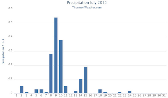
The month of July continued the recent trend of cool, damp weather.  By the time it was said and done though, while temperatures overall were below average, precipitation fell short of normal.

Temperatures were at or above normal for the first few days allowing for a pleasant Independence Day.

The day after, however, a monsoonal weather pattern cooled things down and brought most of the month’s moisture over the following 10 days.

Ridging then built and we settled into a relatively normal period for the final two weeks although precipitation became scarcer.

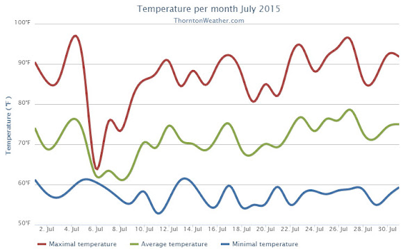
Thornton saw an average temperature for July 2015 of 71.2 degrees.  This was a good bit below the long term Denver average of 74.2 degrees.  Out at Denver International Airport where the Mile High City’s official measurements are taken, the average for the month was 72.8 degrees.

Our temperatures ranged from a high of 96.1 degrees on the 27th down to a low of 53 degrees on the 11th.  Denver saw a maximum of 97 degrees and a minimum of 52 degrees.

Denver averages 2.16 inches of precipitation during July.  Thornton fell a bit short of that mark recording 1.76 inches.  At the airport, only 1.06 inches was recorded.

Click here to view Thornton’s July 2015 climate report.

Thornton, Colorado July 2015 temperatur?e summary. (ThorntonW?eather.com?)
Thornton, Colorado July 2015 precipitat?ion summary. (ThorntonW?eather.com?)
CLIMATE REPORT
NATIONAL WEATHER SERVICE BOULDER, CO
202 PM MDT SAT AUG 1 2015

................................... 

...THE DENVER CO CLIMATE SUMMARY FOR THE MONTH OF JULY 2015... 

CLIMATE NORMAL PERIOD 1981 TO 2010
CLIMATE RECORD PERIOD 1872 TO 2015

WEATHER         OBSERVED          NORMAL  DEPART  LAST YEAR`S
                 VALUE   DATE(S)  VALUE   FROM    VALUE  DATE(S)
                                          NORMAL
................................................................ 
TEMPERATURE (F)
RECORD
 HIGH             105   07/20/2005
 LOW               42   07/04/1903
                        07/31/1873
HIGHEST            97   07/27                        100  07/07
LOWEST             52   07/28                         55  07/17
                                                          07/16
AVG. MAXIMUM     87.6              89.4    -1.8     88.3
AVG. MINIMUM     57.9              58.9    -1.0     60.6
MEAN             72.8              74.2    -1.4     74.5
DAYS MAX >= 90     16              16.0     0.0       17
DAYS MAX <= 32      0               0.0     0.0        0
DAYS MIN <= 32      0               0.0     0.0        0
DAYS MIN <= 0       0               0.0     0.0        0 
PRECIPITATION (INCHES) RECORD  
MAXIMUM         6.41   1965  
MINIMUM         0.01   1901 
TOTALS           1.06              2.16   -1.10     3.85 
DAILY AVG.       0.03              0.07   -0.04     0.12 
DAYS >= .01        12               8.3     3.7        8
DAYS >= .10         3               4.3    -1.3        6
DAYS >= .50         0               1.4    -1.4        2
DAYS >= 1.00        0               0.7    -0.7        2
GREATEST
 24 HR. TOTAL    0.33   07/18/15                    2.85  07/29/14
                        07/18/15                          07/30/14

SNOWFALL (INCHES)
 TOTAL            0.0                                0.0

DEGREE_DAYS
HEATING TOTAL       5                 6      -1        5
 SINCE 7/1          5                 6      -1        5
COOLING TOTAL     251               289     -38      304
 SINCE 1/1        409               444     -35      431

FREEZE DATES
RECORD
 EARLIEST     09/08/1962
 LATEST       06/08/2007
EARLIEST                        10/07
LATEST                          05/05
.................................................. 

WIND (MPH)
AVERAGE WIND SPEED              9.3
RESULTANT WIND SPEED/DIRECTION   3/176
HIGHEST WIND SPEED/DIRECTION    46/320    DATE  07/15
HIGHEST GUST SPEED/DIRECTION    60/330    DATE  07/15

SKY COVER
POSSIBLE SUNSHINE (PERCENT)   MM
AVERAGE SKY COVER           0.60
NUMBER OF DAYS FAIR            4
NUMBER OF DAYS PC             22
NUMBER OF DAYS CLOUDY          5

AVERAGE RH (PERCENT)     52

WEATHER CONDITIONS. NUMBER OF DAYS WITH
THUNDERSTORM              0     MIXED PRECIP               0
HEAVY RAIN                3     RAIN                       1
LIGHT RAIN               16     FREEZING RAIN              0
LT FREEZING RAIN          0     HAIL                       0
HEAVY SNOW                0     SNOW                       0
LIGHT SNOW                0     SLEET                      0
FOG                       7     FOG W/VIS <= 1/4 MILE      0
HAZE                      6

-  INDICATES NEGATIVE NUMBERS.
R  INDICATES RECORD WAS SET OR TIED.
MM INDICATES DATA IS MISSING.
T  INDICATES TRACE AMOUNT.

July 2015 top shots: Monthly photo slideshow

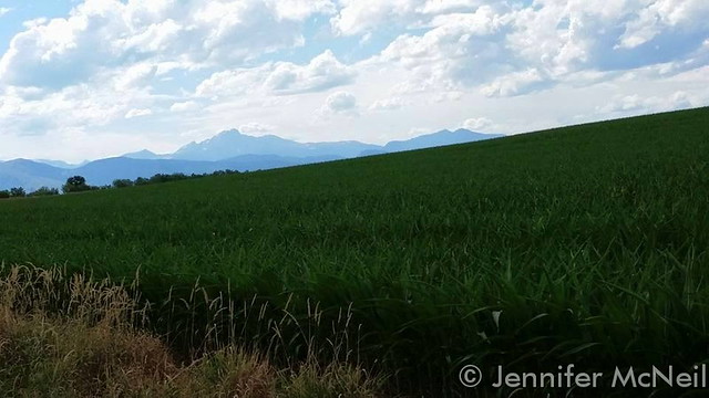
July 11, 2015 - Corn fields on the plains serve as the foreground while the gorgeous Rocky Mountains lie behind. (Jennifer McNeil)
July 11, 2015 – Corn fields on the plains serve as the foreground while the gorgeous Rocky Mountains lie behind. (Jennifer McNeil)

Colorado offers outdoor opportunities unlike any other state and while the summer heat settles in, photos of the amazing scenes across our state provide a view into why we love it here so much.

The weather this time of year has a pretty standard pattern of quickly warming temperatures followed by afternoon thunderstorms that can cool things down.  These storms sometimes provide a good bit of ‘excitement’ and are a prime photo subject.

  • Slideshow updated July 31, 2015

Recreationalists head outdoors and take advantage of urban, suburban and rural opportunities.  As they do, our abundant wildlife that is found just about anywhere comes into focus.

Showcasing images captured by ThorntonWeather.com readers as well as some of our own, our monthly slideshow covers the entire gamut of weather and nature related imagery.   Sunsets, sunrises, wildlife and of course every type of weather condition are vividly depicted.

To learn more about how to send your photo to us for inclusion in the slideshow, see below the slideshow.

[flickr_set id=”72157656079164135″]

What is missing in the slideshow above?  Your photo!

Our monthly photo slideshow is going to feature images that we have taken but more importantly images that you have captured.  The photos can be of anything even remotely weather-related.

Landscapes, current conditions, wildlife, pets, kids.  Whimsical, newsy, artsy.  Taken at the zoo, some other area attraction, a local park, a national park or your backyard.  You name it, we want to see and share it!

Images can be taken in Thornton, Denver or anywhere across the extraordinary Centennial State.  We’ll even take some from out of state if we can tie it to Colorado somehow.

We’ll keep the criteria very open to interpretation with just about any image eligible to be shown in our slideshows.

What do you win for having your image in our slideshow?  We are just a ‘mom and pop’ outfit and make no money from our site so we really don’t have the means to provide prizes.  However you will have our undying gratitude and the satisfaction that your images are shared on the most popular website in Thornton.

To share you images with us and get them included in the slideshow just email them to us or share them with ThorntonWeather.com on any of the various social media outlets.  Links are provided below.

So come on, get those camera’s rolling!

July 2014 top shots: Monthly photo slideshow

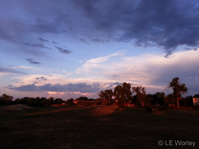
July 3, 2014 - A gorgeous July sunset. (LE Worley)
July 3, 2014 – A gorgeous July sunset. (LE Worley)

The month of July typically brings a pretty tried and true daily weather pattern with hot days and afternoon thunderstorms.  Like any month of the year in Colorado, a wide variety of subjects will be presented for photo opportunities.

Flowers are now in full bloom, wildlife is abundant with many creatures showing their young for the first time, and then of course there is the weather.  Scorching heat, damaging thunderstorms, heavy rains and more are all possible during the month.

  • Slideshow updated July 31, 2014
  • To learn more about how to send your photo to us for inclusion in the slideshow, see below the slideshow.

Showcasing images captured by ThorntonWeather.com readers as well as some of our own, our monthly slideshow covers the entire gamut of weather-related imagery.

Sunsets, sunrises, wildlife and of course every type of weather condition are vividly depicted in images captured from yours and our cameras.

Click the play button below and sit back and enjoy the images.

What is missing in the slideshow above?  Your photo!

Our monthly photo slideshow is going to feature images that we have taken but more importantly images that you have captured.  The photos can be of anything even remotely weather-related.

Landscapes, current conditions, wildlife, pets, kids.  Whimsical, newsy, artsy.  Taken at the zoo, some other area attraction, a local park, a national park or your backyard.  You name it, we want to see and share it!

Images can be taken in Thornton, Denver or anywhere across the extraordinary Centennial State.  We’ll even take some from out of state if we can tie it to Colorado somehow.

We’ll keep the criteria very open to interpretation with just about any image eligible to be shown in our slideshows.

What do you win for having your image in our slideshow?  We are just a ‘mom and pop’ outfit and make no money from our site so we really don’t have the means to provide prizes.  However you will have our undying gratitude and the satisfaction that your images are shared on the most popular website in Thornton.

To share you images with us and get them included in the slideshow just email them to us or share them with ThorntonWeather.com on any of the various social media outlets.  Links are provided below.

So come on, get those camera’s rolling!

Two tornadoes touch down in north Denver metro area, minor damage seen

July 28, 2014 - Image of the tornado at the Rocky Mountain Arsenal. (Ed Dalton)  Click for a larger view.
July 28, 2014 – Image of the tornado at the Rocky Mountain Arsenal. (Ed Dalton) Click for a larger view.

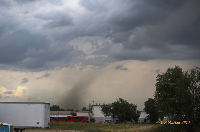
Monday’s forecast called for a chance for thunderstorms but Mother Nature threw in a couple of wildcards in the form of two tornadoes in the area.  The landspout tornadoes caused minor damage in north Denver and were widely seen across much of the area.

The first tornado was reported at 3:53pm just across the Adams County line in Weld County near Fort Lupton.  The twister was the better defined of the two but appears to have struck farmland with no damage reported.

At 4:09pm a second tornado was reported near the Rocky Mountain Arsenal National Wildlife Refuge in Adams County.  A diesel repair shop near 51st and Havana had one of its garage doors ripped off and some material thrown about.

Denver International Airport sent travelers to shelters for a period of time and warning sirens were sounded in Brighton, Commerce City and other nearby locations.

Three people on a small boat on Barr Lake were overturned by the strong thunderstorm winds.  The trio managed to swim to shore and were not injured.

Tuesday’s weather is not expected to contain quite as much excitement as yesterday’s.  However, heavy rain will be possible and a Flash Flood Watch has been issued.

July 2013 State of the Climate: U.S. warmer, wetter than average

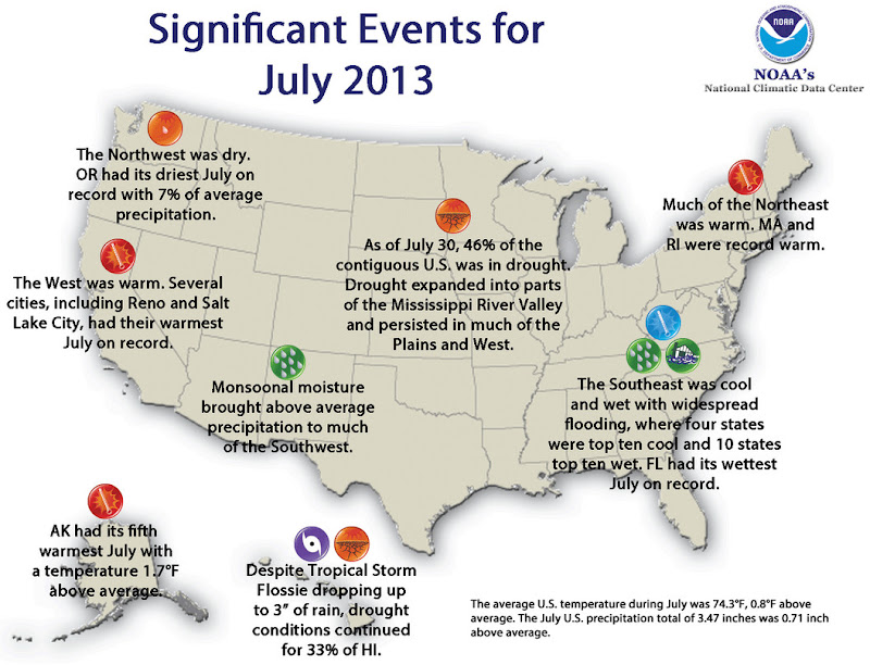
Significant Climate Events - July 2013 (NOAA)
Significant Climate Events – July 2013 (NOAA). Click for larger view.

The National Oceanic and Atmospheric Administration (NOAA) released its July 2013 State of the Climate report saying that while the average U.S. temperature was warmer than normal, precipitation was higher than normal.

As we reported earlier, here in the Denver area temperatures were largely average during the month.  Precipitation was close to normal but fell short of that mark.

The SOTC’s larger view shows the contiguous United States’ average temperature was 0.8° above the 20th century average.  This ranks it as the 30th warmest July on record.

In terms of precipitation, the nation enjoyed a wetter than average month, one that ranks it as the 5th wettest July since record-keeping began.

Below are the climate highlights from NOAA for July 2013.  Click here to view the full, comprehensive report.

From NOAA:

Climate Highlights — July

  • The average temperature for the contiguous U.S. during July was 74.3°F, 0.8°F above the 20th century average, and ranked as the 30th warmest such month on record.
  • The western U.S. was warmer than average, where IdahoNevadaOregon, and Utah each had a top ten warm month. Several cities, including Salt Lake City, Utah, and Reno, Nev., had their warmest July on record.Seven states across the Northeast also had July temperatures ranking among the ten warmest on record, including Massachusetts and Rhode Island, each of which had a record warm July.
  • Locations from the Central and Southern Plains into the Southeast were cooler than average. Four states —AlabamaArkansasMississippi, and Tennessee — had July temperatures that were among the ten coolest on record.
  • The Alaska statewide average temperature was 1.7°F above the 1971-2000 average and ranked as the fifth warmest July on record for the state. Anchorage had its fourth warmest July, and the city set a record with 14 consecutive days above 70°F.
  • The nationally-averaged July precipitation total of 3.47 inches was 0.71 inch above average and was the 5thwettest July on record for the contiguous United States.
  • Wetter-than-average conditions stretched from California, through the Southwest and Plains, and along the Eastern Seaboard. In the Southwest, seasonal monsoonal flow brought above average precipitation to several states, where Arizona and California both had July precipitation totals ranking among their ten wettest. During this time of year in parts of the Southwest, even light precipitation can result in above-average monthly totals but have minimal impacts on alleviating drought conditions.
  • In the East13 states had one of their ten wettest Julys on record, with the highest precipitation totals across the Southeast. Florida had its wettest July on record, with 12.38 inches of rainfall, 4.91 inches above average. The above-average precipitation in the Southeast resulted in widespread flooding and significant damage to crops.
  • The Northwest was particularly dry. Oregon had its driest July on record with only 0.03 inch of rainfall accumulating, 0.41 inch below average. Washington had its eighth driest July. Below-average precipitationwas also observed in the Upper Mississippi River Valley, where Iowa had its tenth driest July.
  • According to the July 30 U.S. Drought Monitor report, 45.6 percent of the contiguous U.S experienced drought conditions, up slightly from the beginning of July. Drought remained entrenched throughout much of the West and in parts of the Central and Southern Plains, and drought expanded into parts of the Lower Mississippi River Valley and Midwest. Over 20 percent of Alaska was in drought at the end of July, with severe drought developing in central parts of the state.
  • Based on NOAA’s Residential Energy Demand Temperature Index (REDTI), the contiguous U.S. temperature-related energy demand during July was above average and ranked as the 41st highest July value in the 119-year period of record.
  • The components of the U.S. Climate Extremes Index (USCEI) that examine extremes in warm night time temperatures, the spatial extent of wetness and drought, and extremes in days with rainfall were all above average. When combined with the other components of the index, the USCEI, as a whole, was only slightly above average. The USCEI is an index that tracks the highest and lowest 10 percent of extremes in temperature, precipitation, tropical cyclones, and drought across the contiguous United States.
  • On a local basis, the number of record warm daily highs and lows (2560) during July was roughly the same as the number of record cool daily highs and lows (2846), although there were slightly more cool records.
  • Climate Highlights — year-to-date (January – July)
  • The year-to-date contiguous U.S. temperature of 51.8°F was 0.5°F above the 20th century average and tied with 1952 as the 42nd warmest January–July on record. Above-average temperatures were observed in the West and Northeast, where CaliforniaNew Hampshire, and Vermont had one of their top ten warmest year-to-date periods. Below-average temperatures stretched from the Northern Plains to the Southeast.
  • The year-to-date contiguous U.S. precipitation total of 19.14 inches was 1.54 inches above average and tied with 1997 as the 22nd wettest January–July on record. However, rainfall was not evenly distributed across the country. Dry precipitation extremes were observed in the West and wet precipitation extremes were observed in the East.
  • CaliforniaIdahoNevada, and Oregon each had a top ten dry year-to-date period. California’s precipitation total of 4.58 inches was record low for the seven-month period at 9.82 inches below average, and 1.69 inches less than the previous record dry January–July of 1898.
  • Above-average precipitation was observed across most locations east of the Rockies, with ten states having one of their ten wettest year-to-date periods. Michigan was record wet with 24.35 inches of precipitation, 6.92 inches above average, and 2.30 inches above the previous record wet January–July of 1950. Several cities, from Fargo, North Dakota to Greenville, South Carolina, had a record wet January–July.
  • Based on NOAA’s Residential Energy Demand Temperature Index (REDTI), the contiguous U.S. temperature-related energy demand during January–July was below average and ranked as the 47th lowest January–July value in the 119-year period of record.
  • The components of the USCEI that examine extremes in the spatial extent of drought, as well as 1-day precipitation totals and days with rainfall were much above average for the year-to-date. When combined with the other components of the index, the USCEI, as a whole, was only slightly above average.

Regional Highlights for the Colorado area

High Plains Region: (Information provided by the High Plains Regional Climate Center)

  • Average temperatures were generally below normal in the east and above normal in the west across the High Plains Region this month. Temperature departures of 2.0-4.0 degrees F (1.1-2.2 degrees C) below normal occurred in eastern Kansas, central South Dakota, western North Dakota, and a few pockets of Nebraska. Meanwhile, western portions of Colorado and Wyoming had temperature departures of 3.0-5.0 degrees F (1.7-2.8 degrees C) above normal. The cooler temperatures in the east were in stark contrast to last year, when a good portion of the area had temperature departures of 6.0-8.0 degrees F (3.3-4.4 degrees C) above normal. Although monthly records were not set, a few stations did manage to sneak in to the top 10 rankings for warmest or coolest July. On the cool side, long-term station Wamego 4 W, which is located in northeastern Kansas, had its 5th coolest July with an average temperature of 75.6 degrees F (24.2 degrees C). The coolest July at Wamego 4 W was 72.0 degrees F (22.2 degrees C) in 1950 (period of record 1912-2013). On the warm side, Lander, Wyoming had its 10th warmest July with 74.2 degrees F (23.4 degrees C). Interestingly, 7 of the top 10 warmest Julys have occurred since 2000 in Lander and the top spot of 75.9 degrees F (24.4 degrees C) occurred in both 2003 and 2006 (period of record 1891-2013). While monthly extremes were not common, numerous daily records occurred throughout the month. One notable record was for the July all-time coolest maximum temperature in Concordia, Kansas. On July 28th, Concordia’s high temperature only reached 62.0 degrees F (16.7 degrees C) and beat out the old record of 63.0 degrees F (17.2 degrees C) which occurred back in 1979 and 1988 (period of record 1885-2013).
  • July precipitation was hit or miss across the High Plains Region. Areas receiving at least 150 percent of normal precipitation included central Kansas, central South Dakota, central and western Colorado, and scattered pockets in eastern Wyoming, north central Nebraska, southwestern South Dakota, and northern North Dakota. While rain was needed to help alleviate ongoing drought conditions, some storms brought heavy rain which caused mudslides in fire burn scars in Colorado and flash flooding in parts of Colorado, Kansas, and Wyoming. Areas which missed out included eastern and central Nebraska, eastern and central North Dakota, and central Wyoming. These areas received less than 50 percent of normal precipitation. Because of the wide range in precipitation, there were stations which ranked in the top 10 driest or wettest Julys on record. With only 11 percent of normal precipitation, Omaha, Nebraska had its 2nd driest July on record with 0.44 inches (11 mm) of precipitation (period of record 1871-2013). The driest on record occurred only last year with 0.01 inches (0 mm). Meanwhile, precipitation in central Kansas helped alleviate drought conditions there, although long-term deficits were still high. For instance, Wichita, Kansas had measurable precipitation on 17 days in July, which broke the old record of 16 in 1950 (period of record 1888-2013). On average, Wichita has about 8 days with measurable precipitation in July. By the end of the month, Wichita received 7.69 inches (195 mm) of precipitation making this July its 4th wettest. Although 232 percent of normal, this was not nearly enough to beat the top spot of 13.37 inches (340 mm) in 1950.
  • The latest U.S. Drought Monitor showed both improvements and degradations over the past month. At the end of July, approximately 64 percent of the Region was in moderate (D1) to exceptional (D4) drought – down just slightly from 67 percent at the end of June. An expansion of abnormally dry conditions (D0) occurred in east-central North Dakota and eastern parts of Kansas, Nebraska, and South Dakota. In addition, two new areas of D1 were introduced in far southeastern South Dakota and northeastern Kansas. One category improvements were made in some areas of north-central and eastern Colorado. There was quite a bit of jostling of drought conditions in Kansas where some areas had improvements, while others had degradations. By the end of the month, 25 percent of the state remained in the D4 designation, however. Wyoming had an increase in severe (D2) and extreme (D3) drought coverage, going from about 47 percent of the state to 52 percent of the state. According to the U.S. Seasonal Drought Outlook released July 18th, the only area of drought expected to improve was in southwestern Colorado. Drought conditions were expected to develop in north-central Colorado and persist elsewhere through October 2013.
  • For more information, please go to the High Plains Regional Climate Center Home Page.

July 2013 weather recap: Mostly normal conditions prevail

Following two hot and dry months in May and June, July brought some relief in the form of near normal temperatures and precipitation.

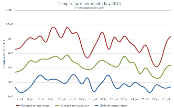
Cooler than normal temperatures started the month during the first couple of days of July.  That changed for the following 10 days when temperatures bounced to above normal levels with Thornton recording eight 90+ degree days during the period.

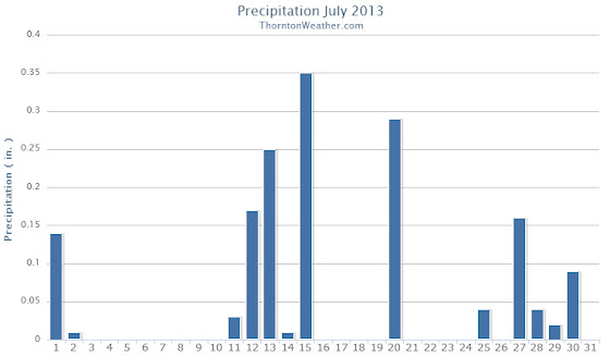
The next few days from the 14th to the 16th brought much cooler conditions and much-needed precipitation.  Seasonal temperatures then settled in through the 23rd.  As the month came to a close, temperatures became more moderate and we even saw three days (the 27th, 28th, and 29th) with highs in the 70s.  Most notably we once again saw some precipitation.

Thornton saw an average temperature during July of 72.1 degrees.  This was a good bit below the long term Denver historical average of 74.3 degrees.  Officially at DIA the average temperature for the month was 74.2 degrees.

We recorded 14 days with temperatures at or equal to 90 degrees.  Temperatures ranged from a high of 98.5 degrees on the 11th down to a low of 52.6 degrees on the 27th.

A reasonable 1.61 inches of precipitation fell into Thornton’s rain bucket during the month.  This was a bit below the average for July of 2.16 inches.  Out at the airport, Denver fared a bit better with 1.98 inches.

Click here to view Thornton’s July 2013 climate summary.

Thornton, Colorado July 2013 Temperatures.
Thornton, Colorado July 2013 Precipitation.
CLIMATE REPORT
NATIONAL WEATHER SERVICE BOULDER, CO
210 AM MDT THU AUG 1 2013

...THE DENVER CO CLIMATE SUMMARY FOR THE MONTH OF JULY 2013... 

CLIMATE NORMAL PERIOD 1981 TO 2010
CLIMATE RECORD PERIOD 1872 TO 2013

WEATHER         OBSERVED          NORMAL  DEPART  LAST YEAR`S
                 VALUE   DATE(S)  VALUE   FROM    VALUE  DATE(S)
                                          NORMAL
................................................................ 
TEMPERATURE (F)
RECORD
 HIGH             105   07/20/2005
 LOW               42   07/04/1903
                        07/31/1873
HIGHEST           100   07/11       105      -5      102  07/21
LOWEST             55   07/02        42      13       57  07/26
AVG. MAXIMUM     88.2              89.4    -1.2     94.4
AVG. MINIMUM     60.4              58.9     1.5     63.4
MEAN             74.3              74.2     0.1     78.9
DAYS MAX >= 90     17              16.0     1.0       27
DAYS MAX <= 32      0               0.0     0.0        0
DAYS MIN <= 32      0               0.0     0.0        0
DAYS MIN <= 0       0               0.0     0.0        0

PRECIPITATION (INCHES)
RECORD
 MAXIMUM         6.41   1965
 MINIMUM         0.01   1901
TOTALS           1.98              2.16   -0.18     0.48
DAILY AVG.       0.06              0.07   -0.01     0.02
DAYS >= .01         7               8.3    -1.3        6
DAYS >= .10         4               4.3    -0.3        2
DAYS >= .50         2               1.4     0.6        0
DAYS >= 1.00        0               0.7    -0.7        0
GREATEST
 24 HR. TOTAL    0.87   07/15 TO 07/15           07/06 TO 07/07
                        07/14 TO 07/15                    07/31 TO 07/31
                        07/15 TO 07/15                    07/31 TO 07/31
 STORM TOTAL       MM                                 MM
 (MM/DD(HH))            MM                    07/07(00) TO 07/07(00)
                                                 07/31(00) TO 07/31(00)1
                                                 07/31(00) TO 07/31(00)1

SNOWFALL (INCHES)
RECORDS
 TOTAL             MM   MM
TOTALS            0.0               0.0

DEGREE_DAYS
HEATING TOTAL       0                 6      -6        0
 SINCE 7/1          0                 6      -6        0
COOLING TOTAL     295               289       6      438
 SINCE 1/1        558               444     114      803

FREEZE DATES
RECORD
 EARLIEST     09/08/1962
 LATEST       06/08/2007
EARLIEST                        10/07
LATEST                          05/05
.................................................. 

WIND (MPH)
AVERAGE WIND SPEED              10.3
RESULTANT WIND SPEED/DIRECTION   3/163
HIGHEST WIND SPEED/DIRECTION    45/050    DATE  07/20
HIGHEST GUST SPEED/DIRECTION    58/040    DATE  07/20

SKY COVER
POSSIBLE SUNSHINE (PERCENT)   MM
AVERAGE SKY COVER           0.60
NUMBER OF DAYS FAIR            5
NUMBER OF DAYS PC             24
NUMBER OF DAYS CLOUDY          2

AVERAGE RH (PERCENT)     50

WEATHER CONDITIONS. NUMBER OF DAYS WITH
THUNDERSTORM              0     MIXED PRECIP               0
HEAVY RAIN                2     RAIN                       3
LIGHT RAIN               13     FREEZING RAIN              0
LT FREEZING RAIN          0     HAIL                       0
HEAVY SNOW                0     SNOW                       0
LIGHT SNOW                0     SLEET                      0
FOG                       6     FOG W/VIS <= 1/4 MILE      1
HAZE                     13

-  INDICATES NEGATIVE NUMBERS.
R  INDICATES RECORD WAS SET OR TIED.
MM INDICATES DATA IS MISSING.
T  INDICATES TRACE AMOUNT.

NOAA: July 2012 goes into record books as hottest month ever for United States

Sweltering, unseasonably warm temperatures gripped much of the contiguous United States last month breaking many records. In the final analysis of the month, NOAA announced that July was the hottest month ever recorded in the U.S.  How hot was it?  Read the rest of this story on Examiner.com

Much of the Lower 48 states saw above average temperatures during July 2012.  Click the image to view the story and slideshow.
Much of the Lower 48 states saw above average temperatures during July 2012. Click the image to view the story and slideshow. (NOAA)

July 2012 Thornton weather recap: Month goes into books as hottest recorded

Thornton's July 2012 weather recap
Thornton recorded its hottest month of the past six years during July 2012.

For the second month in a row, Thornton saw extraordinarily warm temperatures in July.  The month not only was the warmest July ever recorded by ThorntonWeather.com, it was the warmest month recorded since we began operation.

The average temperature for July 2012 was an astonishing 75.5 degrees.  This was 1.8 degrees above Thornton’s average for July over the past six years, a significant increase.

Temperatures ranged from a high of 98.7 degrees on July 1 down to a low of 56.6 degrees on July 11.

In all we recorded 23 days with high temperatures at or above 90 degrees.  We did however manage to escape the month without breaking the century mark.

In terms of precipitation Thornton didn’t fare too poorly.  We recorded 1.92 inches of precipitation in our rain bucket.  This was only 0.03” below the six year average of 1.95 inches.

For comparison, Denver saw an official average monthly temperature of 78.9 degrees as measured at Denver International Airport.  Further, they only recorded 0.48 inch of precipitation.  For more details on Denver’s July 2012 weather, please visit this story on Examiner.com.

More on ThorntonWeather.com:

July 2012 Graphs

Thornton's July 2012 Temperatures

Thornton's July 2012 precipitation