Following two hot and dry months in May and June, July brought some relief in the form of near normal temperatures and precipitation.
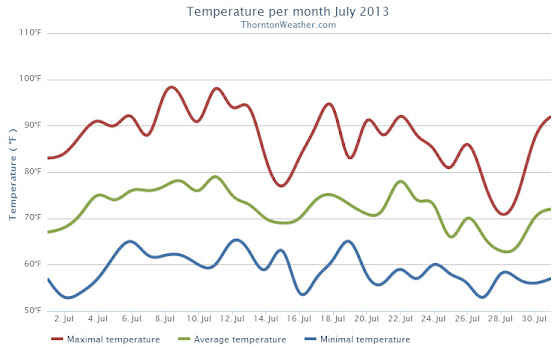
Cooler than normal temperatures started the month during the first couple of days of July. That changed for the following 10 days when temperatures bounced to above normal levels with Thornton recording eight 90+ degree days during the period.
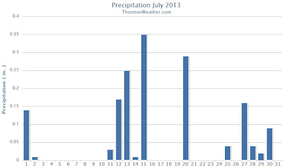
The next few days from the 14th to the 16th brought much cooler conditions and much-needed precipitation. Seasonal temperatures then settled in through the 23rd. As the month came to a close, temperatures became more moderate and we even saw three days (the 27th, 28th, and 29th) with highs in the 70s. Most notably we once again saw some precipitation.
Thornton saw an average temperature during July of 72.1 degrees. This was a good bit below the long term Denver historical average of 74.3 degrees. Officially at DIA the average temperature for the month was 74.2 degrees.
We recorded 14 days with temperatures at or equal to 90 degrees. Temperatures ranged from a high of 98.5 degrees on the 11th down to a low of 52.6 degrees on the 27th.
A reasonable 1.61 inches of precipitation fell into Thornton’s rain bucket during the month. This was a bit below the average for July of 2.16 inches. Out at the airport, Denver fared a bit better with 1.98 inches.
Click here to view Thornton’s July 2013 climate summary.
CLIMATE REPORT
NATIONAL WEATHER SERVICE BOULDER, CO
210 AM MDT THU AUG 1 2013

...THE DENVER CO CLIMATE SUMMARY FOR THE MONTH OF JULY 2013...

CLIMATE NORMAL PERIOD 1981 TO 2010
CLIMATE RECORD PERIOD 1872 TO 2013

WEATHER         OBSERVED          NORMAL  DEPART  LAST YEAR`S
                 VALUE   DATE(S)  VALUE   FROM    VALUE  DATE(S)
                                          NORMAL
................................................................
TEMPERATURE (F)
RECORD
 HIGH             105   07/20/2005
 LOW               42   07/04/1903
                        07/31/1873
HIGHEST           100   07/11       105      -5      102  07/21
LOWEST             55   07/02        42      13       57  07/26
AVG. MAXIMUM     88.2              89.4    -1.2     94.4
AVG. MINIMUM     60.4              58.9     1.5     63.4
MEAN             74.3              74.2     0.1     78.9
DAYS MAX >= 90     17              16.0     1.0       27
DAYS MAX <= 32      0               0.0     0.0        0
DAYS MIN <= 32      0               0.0     0.0        0
DAYS MIN <= 0       0               0.0     0.0        0

PRECIPITATION (INCHES)
RECORD
 MAXIMUM         6.41   1965
 MINIMUM         0.01   1901
TOTALS           1.98              2.16   -0.18     0.48
DAILY AVG.       0.06              0.07   -0.01     0.02
DAYS >= .01         7               8.3    -1.3        6
DAYS >= .10         4               4.3    -0.3        2
DAYS >= .50         2               1.4     0.6        0
DAYS >= 1.00        0               0.7    -0.7        0
GREATEST
 24 HR. TOTAL    0.87   07/15 TO 07/15           07/06 TO 07/07
                        07/14 TO 07/15                    07/31 TO 07/31
                        07/15 TO 07/15                    07/31 TO 07/31
 STORM TOTAL       MM                                 MM
 (MM/DD(HH))            MM                    07/07(00) TO 07/07(00)
                                                 07/31(00) TO 07/31(00)1
                                                 07/31(00) TO 07/31(00)1

SNOWFALL (INCHES)
RECORDS
 TOTAL             MM   MM
TOTALS            0.0               0.0

DEGREE_DAYS
HEATING TOTAL       0                 6      -6        0
 SINCE 7/1          0                 6      -6        0
COOLING TOTAL     295               289       6      438
 SINCE 1/1        558               444     114      803

FREEZE DATES
RECORD
 EARLIEST     09/08/1962
 LATEST       06/08/2007
EARLIEST                        10/07
LATEST                          05/05
..................................................

WIND (MPH)
AVERAGE WIND SPEED              10.3
RESULTANT WIND SPEED/DIRECTION   3/163
HIGHEST WIND SPEED/DIRECTION    45/050    DATE  07/20
HIGHEST GUST SPEED/DIRECTION    58/040    DATE  07/20

SKY COVER
POSSIBLE SUNSHINE (PERCENT)   MM
AVERAGE SKY COVER           0.60
NUMBER OF DAYS FAIR            5
NUMBER OF DAYS PC             24
NUMBER OF DAYS CLOUDY          2

AVERAGE RH (PERCENT)     50

WEATHER CONDITIONS. NUMBER OF DAYS WITH
THUNDERSTORM              0     MIXED PRECIP               0
HEAVY RAIN                2     RAIN                       3
LIGHT RAIN               13     FREEZING RAIN              0
LT FREEZING RAIN          0     HAIL                       0
HEAVY SNOW                0     SNOW                       0
LIGHT SNOW                0     SLEET                      0
FOG                       6     FOG W/VIS <= 1/4 MILE      1
HAZE                     13

-  INDICATES NEGATIVE NUMBERS.
R  INDICATES RECORD WAS SET OR TIED.
MM INDICATES DATA IS MISSING.
T  INDICATES TRACE AMOUNT.