Death toll in Brazilian flooding and landslides climbs over 800

Recent flooding in Brazil has submerged entire towns in water and mud. Image courtesy Blamed (Arquivo pessoal) via Wikimedia Commons

Australia and Brazil have both been besieged by heavy rains and flooding in recent weeks.  While Australia’s damage was more widespread, the death toll in Brazil has been far more severe.

At latest count at least 809 people have been killed in the flooding in areas just north of Rio de Janeiro.  389 are reported dead from the floods and mudslides in Nova Friburgo and 324 in Teresolis.  With at least 200 people missing the toll may eventually exceed 1,000.

More than 20,000 people have been forced out of their homes as flash floods and mud rushed through the Serrana region and the Brazilian government is being heavily criticized for its lax oversight of construction standards. The lack of a proper weather warning system and civil defense plan have also been highlighted by the calamity. 

Many within the country and in the international community are questioning the ability of Brazil to play host to the World Cup and the Olympics later this decade. Brazilian daily newspaper Estado de S. Paulo wrote, “A look at public policy … or the lack thereof … reveals a long chain of unpreparedness, administrative incompetence, technical incapacity, and political irresponsibility.”

The recent deaths far surpass Brazil’s previous worst natural disaster. That event, a flood in the state of Sao Paulo in 1967, claimed 436 lives. 

For complete coverage of all types of natural disasters, please visit the Natural Disasters Examiner.

January 23 to January 29 – This week in Denver weather history

January 23 to January 29 - This week in Denver weather history

When Denver’s weather turns severe it can turn deadly and damaging.  As we look back at this week in Denver weather history we see a time when extreme cold claimed a life and many occasions where wind wreaked havoc and caused damage.

15-23

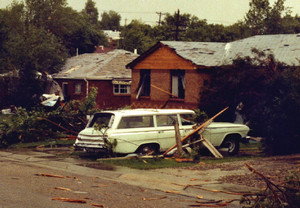
In 1962…a protracted cold spell kept metro Denver in the deep freeze for more than a week.  From the 15th thru the 23rd…low temperatures were zero or below for 9 consecutive days…but a daily record low was set only on the 22nd when the temperature dipped to 14 degrees below zero.  A record low maximum for the date was also set on the 22nd when the temperature climbed to only 11 degrees.  The coldest high temperature was 3 degrees above zero on the 21st…which did not break the record.  The protracted cold was broken for only a few hours on the afternoon of the 20th when Chinook winds warmed the temperature to a high of 38 degrees before another surge of cold arctic air plunged temperatures back into the deep freeze that evening.  The severe cold caused much damage to water systems.  A woman was frozen to death at Morrison.  There were other deaths attributable to the weather…including traffic deaths and heart attacks from overexertion.

18-24

In 2005…a week of mid-winter unseasonably warm weather pushed high temperatures into the 60’s or more on all but one day.  During the period…the highest temperature of 70 degrees on the 20th was a new record maximum for the date.  Low temperatures remained above freezing on 4 of the days.

22-23

In 1982…wind gusts up to 101 mph were clocked at Wondervu. Wind gusts of 60 to 80 mph were common along the Front Range foothills from Boulder north.

22-26

In 1948…the longest period of snowfall on record (92 hours and 3 minutes) occurred in downtown Denver where a total of 13.6 inches of snow fell.  At Stapleton Airport…19.0 inches of snow fell…making it the heaviest snow in January and the 5th heaviest snow of record at that time.  North winds were sustained to a velocity of 23 mph on the 25th…but generally the winds were light throughout the storm.  The snow disrupted traffic…but street clearing was begun soon after it became apparent that the snow would be heavy.  Over the 5 days…temperatures ranged from a high of 48 degrees on the 22nd to a low of 1 degree on the 26th.  Most readings were in the teens and 20’s during the storm.

23

In 1872…a brisk northerly wind set in about noon…blew almost a gale about 6:00 pm…and continued brisk until night.  A light snow commenced during the late afternoon and continued all night.
 
In 1886…northwest winds were sustained to 40 mph in the city around sunrise.  A cold wave accompanied the strong winds.
 
Continue reading January 23 to January 29 – This week in Denver weather history

Aussie teens learn what type of flotation device not to use in a flooding river

Two teens in Australia discovered that certain flotation devices aren't appropriate in a flooding river. (Trevor Pinder)

Sometimes you just can’t save people from themselves.  With Australia battling flooding across four of its states, emergency officials have had their hands full providing relief and rescuing those affected by the disaster.  The Natural Disasters Examiner reports about how the decision by a young couple to test the floodwaters with inflatable sex dolls earlier this week was not met with amusement by authorities. 

The 19-year-old couple chose to enter the waters of the Yarra River near Melbourne with inflatable sex dolls to aid them in their swim.  The rushing waters apparently were too much for the pair – and the dolls – and they soon found themselves in danger.

The young lady held onto a tree while her companion and his doll stood watch and began yelling for help.  A passerby called police and rescue units retrieved the couple from the river.

According to The Telegraph, officials told the couple that sex dolls were “not a recognized flotation device.”  Authorities were not pleased to have had to divert resources for a rescue that should not have been necessary. 

Flooding in Australia has become a disaster of gargantuan proportions as hundreds of thousands of acres across four states have been flooded.  More than 30 people have been killed and tens of thousands of people are now homeless. 

View more images of the water rescue here.

Wednesday’s snowstorm in 10 seconds or less

To say today’s snowstorm was a fast mover doesn’t do it justice.  The storm hit fast and furious and many doubted our forecasts for only light snowfall.  But, as quickly as it arrived the winter storm departed and the event was over by nightfall.

In a span of three hours or so Thornton received 1.2 inches of snow.  Of course it is a bummer to have to withstand the traffic problems caused by a storm that brought so little.  To top it off we now have to wash our cars which hadn’t been clean but for a few days.  Not much return for the hassle, even if we need the moisture.  🙂

The time lapse video below captures the entire event from start to finish and does it in about 9 seconds.

California’s ‘big one’ may not be an earthquake

A 'super storm' like one that struck California 150 years ago would flood an area hundreds of miles long. (USGS / Google Earth)

California and earthquakes go together like coffee and a cup but a new study suggests that an entirely different kind of disaster may have a bigger impact.  The U.S. Geological Survey gathered 117 scientists to evaluate a hypothetical – but possible – “super storm” and its impact on the Golden State. 

At the end of 1861 and into the beginning of 1862 a very wet Pacific storm inundated California with rain.  This storm turned much of the Sacramento Valley into an inland sea and flooded an area hundreds of miles long. 

Today, California is the United State’s most populous state and it has the equivalent of the eighth largest economy in the world.  The study shows that if a similar storm were to occur today the result would be disastrous. 

The implications of this disaster scenario are tremendous and stretch far beyond California’s borders.  Further, one has to wonder ‘what if’ Thornton and the Denver area were presented with a similar scenario? 

Read more about the study at the Natural Disasters Examiner.

ThorntonWeather.com enhances radar system and satellite imagery

ThorntonWeather.com's new satellite imagery allows a close in, bird's eye view of the weather.

For more than four years ThorntonWeather.com has been the one and only source for truly local weather for Thornton, Colorado.  We are continually improving the site to provide more information and now we have greatly enhanced two of our most popular features.

First up and arguably the most exciting is the satellite imagery.  Using imagery provided by NOAA you begin by selecting a region – northeastern Colorado for a look close to home or perhaps a look at the entire United States.  Once you go there, you are given an animated display powered by Adobe Flash. 

Best of all with the new satellite system is a series of overlays that you can select using the boxes above the satellite image.  You can add the county outlines, major highways, and even weather conditions (the selections vary depending on the region).  For each region you can also select an enhancement.  These different color palettes are useful for spotting wildfires, the most significant areas of a storm and more.

You can access the satellite imagery by going to Radar & Maps on the menu on the left then select “Satellite Imagery.”

Last but not least is a revamped radar display system.  The radar is now fully animated like the new satellite which gives you much greater control.  You can speed up the animation, slow it down and pause the display, all of which are useful to seeing where the weather is headed.  You can even zoom in on a spot on the display. 

ThorntonWeather.com Super Doppler RadarTo access the radar go to Radar & Maps on the menu on the left and select “TW Super Doppler Radar.”

These are but two of a number of features added in recent months.  Be sure to check out our website change log for all the details.  For all the latest you can also follow us on Twitter and join us on Facebook.

Take a look and if you have any comments, questions or ideas for future enhancements to the site leave them below or contact us.

Avalanche keeps US 40 over Berthoud Pass closed; Search continues for missing snowboarder

CDOT crews work to clear an avalanche that has covered US 40 over Berthoud Pass. (CDOT)
CDOT crews work to clear an avalanche that has covered US 40 over Berthoud Pass. Click to view a larger image. (CDOT)

With hurricane force winds and heavy snowfall conditions in Colorado’s high country have been treacherous in recent days.  The search continues for a snowboarder that disappeared at the height of the storm and an avalanche keeps US 40 over Berthoud Pass closed.

The winter storm that struck yesterday brought with it winds to 99 mph near Loveland Pass and 85 mph near one of the Breckenridge Ski Area mountains.  The strong winds coupled with the snow that fell has created dangerous avalanche conditions in the high country.

US 40 over Berthoud, US 6 over Loveland Pass and Interstate 70 were all closed at some point over the past 36 hours.  I-70 has reopened but US 6 remains closed due to adverse conditions and avalanche control work. 

While the skies have cleared over US 40 and Berthoud Pass, the massive avalanche has forced the highway to remain closed.  Images released by the Colorado Department of Transportation (CDOT) show the highway completed covered from the slide.  No ETA has been provided as to when the pass will open. 

  • Editor’s note – CDOT reports Berthoud Pass opened at 5:40pm. Read on though for for other information.

Search and rescue teams from Grand County were also combing the Berthoud Pass area for a missing snowboarder and his dog although it is unknown if that is in the same location as the avalanche.   26-year-old Jeffrey Miller, his dog and a companion were separated at the height of yesterday’s storm.  The severe weather conditions have limited the search for Miller. 

The snow from the avalanche has completely covered US 40 over Berthoud Pass. Click the image for a larger version. (CDOT)

An Avalanche Warning is in effect for the Front Range mountain areas as well as the Vail and Summit County Areas.  The Colorado Avalanche Information Center warns of high danger levels saying, “Natural and human-triggered slides are likely in avalanche terrain where significant storm and wind-blown snow has accumulated.”  Most other areas in Colorado have been given a “considerable” danger rating for avalanches. 

Colorado’s weather this winter has been a story of two halves.  The eastern half of the state and the Denver area have been warmer and much drier than normal.  The western half of Colorado however has had a great deal of snow with some basins reporting more than 130% of normal snowpack.

More on ThorntonWeather.com:

Animated video depicts hypothetical global warming debate

A YouTube video puts a humorous - but thought provoking - spin on the debate about manmade climate change. (YouTube / Battlefield315)

From the high-minded forums in the scientific community to the halls of Congress to main street America, manmade climate change is a hot topic (pun intended).  Some scientists would have us believe the debate is over, Congress uses the theory to impress new taxes on citizens, and Americans are left wondering what to believe. 

This week NOAA announced that 2010 tied as the warmest year on record and many immediately seized on it as proof of manmade climate change.  Despite many arguments to the contrary, it becomes difficult to have a rational discussion about the merits of these claims as both sides can become quite set in their beliefs. 

A new video, while humorous, portrays a hypothetical debate between a global warming alarmist and a denier and offers up some serious questions and doubts about the theory.  From former Vice President Al Gore’s role as global warming cheerleader to the revelation about the behavior of “climate scientists” seen in the wake of the Climategate scandal the video presents them all. 

Despite erroneous information continually being discovered in alarmists’ claims, many, like the alarmist in the movie, choose to turn a blind eye.  While humorous, the video does highlight many of the valid questions that are asked by those who have their doubts about manmade climate change. 

Skeptics of the anthropogenic global warming theory need to remember that while man may not be responsible for the overall warming seen in recent decades, as custodians of this planet we do shoulder some burden.  Rational actions to keep the planet clean, move us toward energy independence and ensure we aren’t causing damage need to be considered.

For more about climate change, head on over to the Climate Change Examiner.

January 16 to January 22 – This week in Denver weather history

January 16 to January 22 - This week in Denver weather history

Our look back at this week in Denver weather history carries with it one overriding condition – wind.  In January it is not uncommon for us to experience Chinook winds which are a blessing and a curse.  These winds bring warm temperatures which are welcome in our coldest month of the year.  However they also can run at extraordinary speeds and at their worst cause a great deal of damage. 

13-16

In 1888…a cold air mass settled over the city and caused temperatures to plunge well below zero on four consecutive days…but only one temperature record was set.  Minimum temperatures dipped to 4 degrees below zero on the 13th… 19 degrees below zero on the 14th…20 degrees below zero on the 15th…and 11 degrees below zero on the 16th.  The maximum temperature of only 4 degrees below zero on the 14th was a record low maximum for the date.  North winds were sustained to 30 mph on the 13th.

14-21

In 1930…a protracted cold spell occurred when low temperatures plunged below zero on 8 consecutive days.  The coldest low temperatures of 20 degrees below zero on the 17th and 19 degrees below zero on the 16th were record minimums for the dates.  High temperatures during the period ranged from 18 on the 18th to zero on the 20th.  Two degrees on the 15th was a record low maximum temperature for the date.

15-16

In 1967…a major windstorm struck Boulder.  The storm was described at the time as the worst single windstorm in the history of Boulder in terms of damage.  Winds reached 125 mph at the National Center for Atmospheric Research and at Boulder airport.  Winds gusted to 84 mph downtown.  Damage totaled a half million dollars in Boulder where some minor injuries were reported.  At the Boulder municipal airport… 14 light airplanes were severely damaged.  The second floor of a warehouse was blown down…damaging two nearby moving vans.  A mobile home was blown over south of Boulder… Injuring one woman.  The roof of a department store was blown in.  There was widespread damage to houses…autos… And power lines from wind and flying debris.  Strong winds also occurred in Denver and Golden…but damage was only minor.  At Stapleton International Airport…west winds gusted to 43 mph on the 15th and to 45 mph on the 16th.
 
In 1981…heavy snow of 6 to 10 inches accumulated across metro Denver.  Snowfall totaled only 1.8 inches at Stapleton International Airport where east winds gusted to 21 mph on the 15th.
 
In 1991…a Pacific storm system moved across metro Denver. Snowfall totaled 3 to 7 inches with 3 inches in Aurora… Denver…and Castle Rock…4 inches in Arvada…and 7 inches at South Platte station just southwest of Denver. Snowfall totaled only 2.9 inches at Stapleton International Airport where north winds gusted to 21 mph on the 16th.
 
In 2001…heavy snow fell across the Front Range foothills and urban corridor.  The combination of careless driving and snowpacked highways resulted in 3 multi-vehicle accidents involving 30 vehicles…along I-25 in Douglas County.  Eleven people were injured and one was killed. Snow amounts included:  11 inches in Evergreen; 10 inches at Eldorado Springs and Genesee; 8 inches at Broomfield… Ken Caryl Ranch…and Thornton; and 5 to 7 inches in Arvada…Bailey…Crow Hill…Gross Reservoir…Lakewood… Louisville…Westminster…and near Loveland.  Snowfall totaled 2.7 inches at the site of the former Stapleton International Airport.

Continue reading January 16 to January 22 – This week in Denver weather history

Rebuilding progress in Haiti slow to come even one year after earthquake

January 15, 2010 - Damaged buildings in Haiti's capital of Port-au-Prince after a massive earthquake on January 12, 2010. The devastation from the quake was massive and rebuilding has been impossibly slow. View more images in the slideshow below. (IFRC/Eric Quintero)

Early on the morning of January 12, 2010 a massive 7.0 earthquake struck Haiti leaving death and destruction.  Despite an immediate outpouring, rebuilding of the Northern Hemisphere’s poorest nation has been slow, hampered by corruption and bureaucracy. 

The quake, Centered 10 miles from Port-Au-Prince, buildings were reduced to rubble within minutes burying thousands of people alive.  Aftershocks rocked the nation for weeks collapsing structures that had withstood the initial shaking. 

As many as 230,000 people were killed in the earthquake.  An estimated 300,000 were injured and 250,000 homes and 30,000 businesses were destroyed. 

Billions of dollars in aid pledged

Individual countries, charitable organizations and the United Nations rushed aid to the impoverished country.  By March, 2010 more than $12 billion in aid had been pledged but it has been slow to arrive and its disbursement toward relief efforts even slower.

According to the United Nations, funding from all types of organizations was to total $2 billion in 2010 alone.  A failure to follow through by all groups has resulted in only $1.3 billion being received. 

Squalid living conditions bring disease

The earthquake left as many as 1.5 million residents without homes.  Tent cities erected by humanitarian groups are now home to 1.2 million people, 375,000 of whom are children. 

The conditions are deplorable and concerns of disease outbreaks came to fruition last year.  An outbreak of cholera afflicted 155,000 people and has killed nearly 4,000. 

Continue reading Rebuilding progress in Haiti slow to come even one year after earthquake

Weather, natural disasters & climate news and information.