The lowest temperature today was a very mild 70 degrees at 1:50 a.m. This is a new record high minimum for August 20 easily besting the old record of 67 degrees set in 2007 and previous years.
Denver officially set another high temperature record. However, is it accurate to compare measurements taken at DIA with historical records taken 14 miles away?
Summer 2013 had been a relatively cool one – up until this latter half of August. The Mile High City set another record high temperature and while it was assuredly hot, questions continue to arise over the comparison of measurements at DIA with Denver’s historical records.
At 1:34 p.m. the mercury climbed to 99 degrees at Denver International Airport. This beats the previous record high temperature for the date of 98 degrees set in 1987 at the old Stapleton International Airport.
Here in Thornton we were just a bit cooler with the mercury topping out at 97.8 degrees at 2:23 p.m. This was in fact our second highest temperature of the year. On June 11 we measured 99.2 degrees. Click here to view Thornton’s 2013 temperature records.
At midnight tonight we may see yet another record fall. The record high minimum for today’s date is 67 degrees. This morning the temperature only dropped to 71 degrees at DIA. If by midnight we don’t drop to the 67 degree mark, that will be another record for the Mile High City.
Today’s record is the third in the past four days. On Sunday, August 18 we tied the record high for that date of 98 degrees. That followed a record-breaker on Saturday the 17th when the mercury topped 97 degrees, breaking the old record for that date of 96 degrees.
One thing these records do continue to teach us is how invalid it is to compare records at Denver International Airport compared to historical locations where Denver’s official temperature was measured prior to 1994.
Today for instance, the station at Denver City Park recorded 97 degrees.
Hot yes. Record-setting no.
Similarly, on Sunday the 18th City Park recorded 95 degrees versus DIA’s mark of 98 degrees. On Saturday when DIA recorded a record-breaking 97 degrees, City Park saw 96 degrees.
The difference in measurements is something we have seen repeatedly since 1994. The move of Denver’s official monitoring station is corrupting the city’s climate record and has wide implications.
With a location 14 miles east of where official temperatures were measured prior to DIA, it is in an entirely different microclimate and as a result it experiences different conditions – sometimes considerably different – to locations closer to downtown.
If we can’t accurately compare our temperatures, how are we to believe climate change alarmists that warn of global warming?
For more on the topic of Denver’s problematic weather station, see these previous stories:
Despite dire warnings from climate change alarmists, one measure of ‘extreme weather’ has seen an exceptionally quiet year – tornadoes. The latest data on tornadoes in the United States from NOAA’s Storm Prediction Center (SPC) shows a distinct lack of one of Mother Nature’s most devastating phenomena in 2013. The measurements, as well as others, have confounded those who have warned that anthropogenic global warming would lead to more devastating natural disasters.
At 3:08 p.m. the mercury climbed to 98 degrees. The last time the date saw readings that high was in 2011.
Here in Thornton we were a bit cooler – but not by much. Our temperature topped out at 95 degrees at 3:19 p.m. This mirrored our high temperature yesterday.
We expect at least a couple more days of these well-above normal temperatures as we head into the workweek. After that we should start to cool down a bit. Click here to view the extended forecast.
Don’t miss a thing when it comes to our ever changing weather! Be sure to ‘like’ us on Facebook, follow us on Twitter and add us to your Google+ circles.
The mercury climbed with great efficiency today leading to a record-breaking temperature for the date. As measured at Denver International Airport, Denver’s temperature topped out at 2:28 p.m. reaching 97 degrees. This breaks the old record for August 17 of 96 degrees set most recently in 1994.
Here in Thornton we were a bit cooler – but not by much. Our temperature topped out at 95 degrees at 2:43 p.m.
Above normal temperatures, but probably not record-setting, are expected to stay with us through at least the first half of the week. Tomorrow and Monday do offer just a slight chance for thunderstorms. Click here to view the extended forecast: http://www.thorntonweather.com/forecast.php
Don’t miss a thing when it comes to our ever changing weather! Be sure to ‘like’ us on Facebook, follow us on Twitter and add us to your Google+ circles.
The Nike Weatherman Pack is a series of shoes from the popular athletic wear maker inspired by Doppler radar. Click the image to view a slideshow of the new sneakers. (Nike)
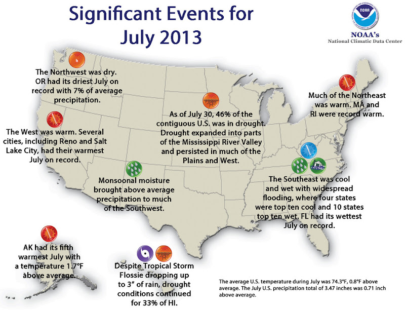
Significant Climate Events – July 2013 (NOAA). Click for larger view.
The National Oceanic and Atmospheric Administration (NOAA) released its July 2013 State of the Climate report saying that while the average U.S. temperature was warmer than normal, precipitation was higher than normal.
As we reported earlier, here in the Denver area temperatures were largely average during the month. Precipitation was close to normal but fell short of that mark.
The SOTC’s larger view shows the contiguous United States’ average temperature was 0.8° above the 20th century average. This ranks it as the 30th warmest July on record.
In terms of precipitation, the nation enjoyed a wetter than average month, one that ranks it as the 5th wettest July since record-keeping began.
The average temperature for the contiguous U.S. during July was 74.3°F, 0.8°F above the 20th century average, and ranked as the 30th warmest such month on record.
The western U.S. was warmer than average, where Idaho, Nevada, Oregon, and Utah each had a top ten warm month. Several cities, including Salt Lake City, Utah, and Reno, Nev., had their warmest July on record.Seven states across the Northeast also had July temperatures ranking among the ten warmest on record, including Massachusetts and Rhode Island, each of which had a record warm July.
The Alaska statewide average temperature was 1.7°F above the 1971-2000 average and ranked as the fifth warmest July on record for the state. Anchorage had its fourth warmest July, and the city set a record with 14 consecutive days above 70°F.
The nationally-averaged July precipitation total of 3.47 inches was 0.71 inch above average and was the 5thwettest July on record for the contiguous United States.
Wetter-than-average conditions stretched from California, through the Southwest and Plains, and along the Eastern Seaboard. In the Southwest, seasonal monsoonal flow brought above average precipitation to several states, where Arizona and California both had July precipitation totals ranking among their ten wettest. During this time of year in parts of the Southwest, even light precipitation can result in above-average monthly totals but have minimal impacts on alleviating drought conditions.
In the East, 13 states had one of their ten wettest Julys on record, with the highest precipitation totals across the Southeast. Florida had its wettest July on record, with 12.38 inches of rainfall, 4.91 inches above average. The above-average precipitation in the Southeast resulted in widespread flooding and significant damage to crops.
The Northwest was particularly dry. Oregon had its driest July on record with only 0.03 inch of rainfall accumulating, 0.41 inch below average. Washington had its eighth driest July. Below-average precipitationwas also observed in the Upper Mississippi River Valley, where Iowa had its tenth driest July.
According to the July 30 U.S. Drought Monitor report, 45.6 percent of the contiguous U.S experienced drought conditions, up slightly from the beginning of July. Drought remained entrenched throughout much of the West and in parts of the Central and Southern Plains, and drought expanded into parts of the Lower Mississippi River Valley and Midwest. Over 20 percent of Alaska was in drought at the end of July, with severe drought developing in central parts of the state.
The components of the U.S. Climate Extremes Index (USCEI) that examine extremes in warm night time temperatures, the spatial extent of wetness and drought, and extremes in days with rainfall were all above average. When combined with the other components of the index, the USCEI, as a whole, was only slightly above average. The USCEI is an index that tracks the highest and lowest 10 percent of extremes in temperature, precipitation, tropical cyclones, and drought across the contiguous United States.
On a local basis, the number of record warm daily highs and lows (2560) during July was roughly the same as the number of record cool daily highs and lows (2846), although there were slightly more cool records.
The year-to-date contiguous U.S. temperature of 51.8°F was 0.5°F above the 20th century average and tied with 1952 as the 42nd warmest January–July on record. Above-average temperatures were observed in the West and Northeast, where California, New Hampshire, and Vermont had one of their top ten warmest year-to-date periods. Below-average temperatures stretched from the Northern Plains to the Southeast.
The year-to-date contiguous U.S. precipitation total of 19.14 inches was 1.54 inches above average and tied with 1997 as the 22nd wettest January–July on record. However, rainfall was not evenly distributed across the country. Dry precipitation extremes were observed in the West and wet precipitation extremes were observed in the East.
California, Idaho, Nevada, and Oregon each had a top ten dry year-to-date period. California’s precipitation total of 4.58 inches was record low for the seven-month period at 9.82 inches below average, and 1.69 inches less than the previous record dry January–July of 1898.
Above-average precipitation was observed across most locations east of the Rockies, with ten states having one of their ten wettest year-to-date periods. Michigan was record wet with 24.35 inches of precipitation, 6.92 inches above average, and 2.30 inches above the previous record wet January–July of 1950. Several cities, from Fargo, North Dakota to Greenville, South Carolina, had a record wet January–July.
Based on NOAA’s Residential Energy Demand Temperature Index (REDTI), the contiguous U.S. temperature-related energy demand during January–July was below average and ranked as the 47th lowest January–July value in the 119-year period of record.
The components of the USCEI that examine extremes in the spatial extent of drought, as well as 1-day precipitation totals and days with rainfall were much above average for the year-to-date. When combined with the other components of the index, the USCEI, as a whole, was only slightly above average.
Average temperatures were generally below normal in the east and above normal in the west across the High Plains Region this month. Temperature departures of 2.0-4.0 degrees F (1.1-2.2 degrees C) below normal occurred in eastern Kansas, central South Dakota, western North Dakota, and a few pockets of Nebraska. Meanwhile, western portions of Colorado and Wyoming had temperature departures of 3.0-5.0 degrees F (1.7-2.8 degrees C) above normal. The cooler temperatures in the east were in stark contrast to last year, when a good portion of the area had temperature departures of 6.0-8.0 degrees F (3.3-4.4 degrees C) above normal. Although monthly records were not set, a few stations did manage to sneak in to the top 10 rankings for warmest or coolest July. On the cool side, long-term station Wamego 4 W, which is located in northeastern Kansas, had its 5th coolest July with an average temperature of 75.6 degrees F (24.2 degrees C). The coolest July at Wamego 4 W was 72.0 degrees F (22.2 degrees C) in 1950 (period of record 1912-2013). On the warm side, Lander, Wyoming had its 10th warmest July with 74.2 degrees F (23.4 degrees C). Interestingly, 7 of the top 10 warmest Julys have occurred since 2000 in Lander and the top spot of 75.9 degrees F (24.4 degrees C) occurred in both 2003 and 2006 (period of record 1891-2013). While monthly extremes were not common, numerous daily records occurred throughout the month. One notable record was for the July all-time coolest maximum temperature in Concordia, Kansas. On July 28th, Concordia’s high temperature only reached 62.0 degrees F (16.7 degrees C) and beat out the old record of 63.0 degrees F (17.2 degrees C) which occurred back in 1979 and 1988 (period of record 1885-2013).
July precipitation was hit or miss across the High Plains Region. Areas receiving at least 150 percent of normal precipitation included central Kansas, central South Dakota, central and western Colorado, and scattered pockets in eastern Wyoming, north central Nebraska, southwestern South Dakota, and northern North Dakota. While rain was needed to help alleviate ongoing drought conditions, some storms brought heavy rain which caused mudslides in fire burn scars in Colorado and flash flooding in parts of Colorado, Kansas, and Wyoming. Areas which missed out included eastern and central Nebraska, eastern and central North Dakota, and central Wyoming. These areas received less than 50 percent of normal precipitation. Because of the wide range in precipitation, there were stations which ranked in the top 10 driest or wettest Julys on record. With only 11 percent of normal precipitation, Omaha, Nebraska had its 2nd driest July on record with 0.44 inches (11 mm) of precipitation (period of record 1871-2013). The driest on record occurred only last year with 0.01 inches (0 mm). Meanwhile, precipitation in central Kansas helped alleviate drought conditions there, although long-term deficits were still high. For instance, Wichita, Kansas had measurable precipitation on 17 days in July, which broke the old record of 16 in 1950 (period of record 1888-2013). On average, Wichita has about 8 days with measurable precipitation in July. By the end of the month, Wichita received 7.69 inches (195 mm) of precipitation making this July its 4th wettest. Although 232 percent of normal, this was not nearly enough to beat the top spot of 13.37 inches (340 mm) in 1950.
The latest U.S. Drought Monitor showed both improvements and degradations over the past month. At the end of July, approximately 64 percent of the Region was in moderate (D1) to exceptional (D4) drought – down just slightly from 67 percent at the end of June. An expansion of abnormally dry conditions (D0) occurred in east-central North Dakota and eastern parts of Kansas, Nebraska, and South Dakota. In addition, two new areas of D1 were introduced in far southeastern South Dakota and northeastern Kansas. One category improvements were made in some areas of north-central and eastern Colorado. There was quite a bit of jostling of drought conditions in Kansas where some areas had improvements, while others had degradations. By the end of the month, 25 percent of the state remained in the D4 designation, however. Wyoming had an increase in severe (D2) and extreme (D3) drought coverage, going from about 47 percent of the state to 52 percent of the state. According to the U.S. Seasonal Drought Outlook released July 18th, the only area of drought expected to improve was in southwestern Colorado. Drought conditions were expected to develop in north-central Colorado and persist elsewhere through October 2013.
President Barack Obama’s former campaign organization turned political action committee called this month ‘Action August.’ When it comes to climate change however, not many are inclined to take action as demonstrated by a distinct lack of attendees at an event yesterday in Washington D.C. Read the rest of this story about the embarrassing turn out on Examiner.com
Many folks noticed the lack of new stories post last week other than a photo or two on our Facebook page. We took the week off for some much needed R & R and were able to enjoy one of our favorite parts of the state.
The image below was taken in Gunnison National Forest a little ways north of Taylor Reservoir. In the foreground is Lilly Pond, in the background the Collegiate Peaks.
The stunning greens and blues truly were as bright as the image shows. While rain was far too prevalent for our liking during our time in the area, the scenery was amazing.
Lilly Pond and the Collegiate Peaks in Gunnison National Forest (ThorntonWeather.com). Click for a larger view.
Following two hot and dry months in May and June, July brought some relief in the form of near normal temperatures and precipitation.
Cooler than normal temperatures started the month during the first couple of days of July. That changed for the following 10 days when temperatures bounced to above normal levels with Thornton recording eight 90+ degree days during the period.
The next few days from the 14th to the 16th brought much cooler conditions and much-needed precipitation. Seasonal temperatures then settled in through the 23rd. As the month came to a close, temperatures became more moderate and we even saw three days (the 27th, 28th, and 29th) with highs in the 70s. Most notably we once again saw some precipitation.
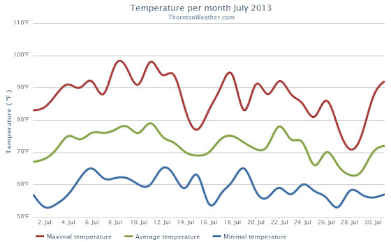
Thornton saw an average temperature during July of 72.1 degrees. This was a good bit below the long term Denver historical average of 74.3 degrees. Officially at DIA the average temperature for the month was 74.2 degrees.
We recorded 14 days with temperatures at or equal to 90 degrees. Temperatures ranged from a high of 98.5 degrees on the 11th down to a low of 52.6 degrees on the 27th.
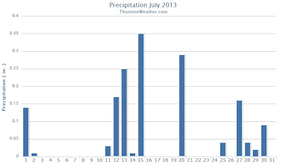
A reasonable 1.61 inches of precipitation fell into Thornton’s rain bucket during the month. This was a bit below the average for July of 2.16 inches. Out at the airport, Denver fared a bit better with 1.98 inches.
Thornton, Colorado July 2013 Temperatures.Thornton, Colorado July 2013 Precipitation.
CLIMATE REPORT
NATIONAL WEATHER SERVICE BOULDER, CO
210 AM MDT THU AUG 1 2013

...THE DENVER CO CLIMATE SUMMARY FOR THE MONTH OF JULY 2013...

CLIMATE NORMAL PERIOD 1981 TO 2010
CLIMATE RECORD PERIOD 1872 TO 2013

WEATHER         OBSERVED          NORMAL  DEPART  LAST YEAR`S
                 VALUE   DATE(S)  VALUE   FROM    VALUE  DATE(S)
                                          NORMAL
................................................................
TEMPERATURE (F)
RECORD
 HIGH             105   07/20/2005
 LOW               42   07/04/1903
                        07/31/1873
HIGHEST           100   07/11       105      -5      102  07/21
LOWEST             55   07/02        42      13       57  07/26
AVG. MAXIMUM     88.2              89.4    -1.2     94.4
AVG. MINIMUM     60.4              58.9     1.5     63.4
MEAN             74.3              74.2     0.1     78.9
DAYS MAX >= 90     17              16.0     1.0       27
DAYS MAX <= 32      0               0.0     0.0        0
DAYS MIN <= 32      0               0.0     0.0        0
DAYS MIN <= 0       0               0.0     0.0        0

PRECIPITATION (INCHES)
RECORD
 MAXIMUM         6.41   1965
 MINIMUM         0.01   1901
TOTALS           1.98              2.16   -0.18     0.48
DAILY AVG.       0.06              0.07   -0.01     0.02
DAYS >= .01         7               8.3    -1.3        6
DAYS >= .10         4               4.3    -0.3        2
DAYS >= .50         2               1.4     0.6        0
DAYS >= 1.00        0               0.7    -0.7        0
GREATEST
 24 HR. TOTAL    0.87   07/15 TO 07/15           07/06 TO 07/07
                        07/14 TO 07/15                    07/31 TO 07/31
                        07/15 TO 07/15                    07/31 TO 07/31
 STORM TOTAL       MM                                 MM
 (MM/DD(HH))            MM                    07/07(00) TO 07/07(00)
                                                 07/31(00) TO 07/31(00)1
                                                 07/31(00) TO 07/31(00)1

SNOWFALL (INCHES)
RECORDS
 TOTAL             MM   MM
TOTALS            0.0               0.0

DEGREE_DAYS
HEATING TOTAL       0                 6      -6        0
 SINCE 7/1          0                 6      -6        0
COOLING TOTAL     295               289       6      438
 SINCE 1/1        558               444     114      803

FREEZE DATES
RECORD
 EARLIEST     09/08/1962
 LATEST       06/08/2007
EARLIEST                        10/07
LATEST                          05/05
..................................................

WIND (MPH)
AVERAGE WIND SPEED              10.3
RESULTANT WIND SPEED/DIRECTION   3/163
HIGHEST WIND SPEED/DIRECTION    45/050    DATE  07/20
HIGHEST GUST SPEED/DIRECTION    58/040    DATE  07/20

SKY COVER
POSSIBLE SUNSHINE (PERCENT)   MM
AVERAGE SKY COVER           0.60
NUMBER OF DAYS FAIR            5
NUMBER OF DAYS PC             24
NUMBER OF DAYS CLOUDY          2

AVERAGE RH (PERCENT)     50

WEATHER CONDITIONS. NUMBER OF DAYS WITH
THUNDERSTORM              0     MIXED PRECIP               0
HEAVY RAIN                2     RAIN                       3
LIGHT RAIN               13     FREEZING RAIN              0
LT FREEZING RAIN          0     HAIL                       0
HEAVY SNOW                0     SNOW                       0
LIGHT SNOW                0     SLEET                      0
FOG                       6     FOG W/VIS <= 1/4 MILE      1
HAZE                     13

-  INDICATES NEGATIVE NUMBERS.
R  INDICATES RECORD WAS SET OR TIED.
MM INDICATES DATA IS MISSING.
T  INDICATES TRACE AMOUNT.
Weather, natural disasters & climate news and information.

 Not to be entirely outdone by
 ")

.")