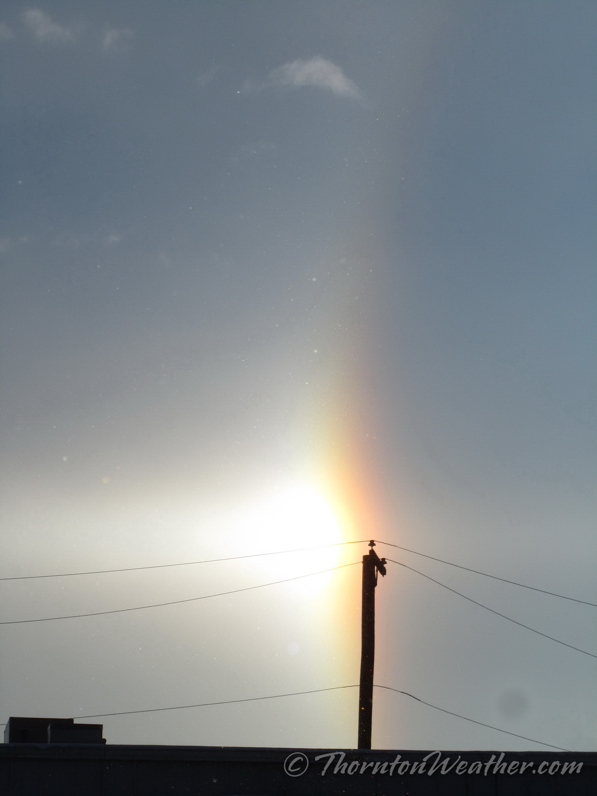
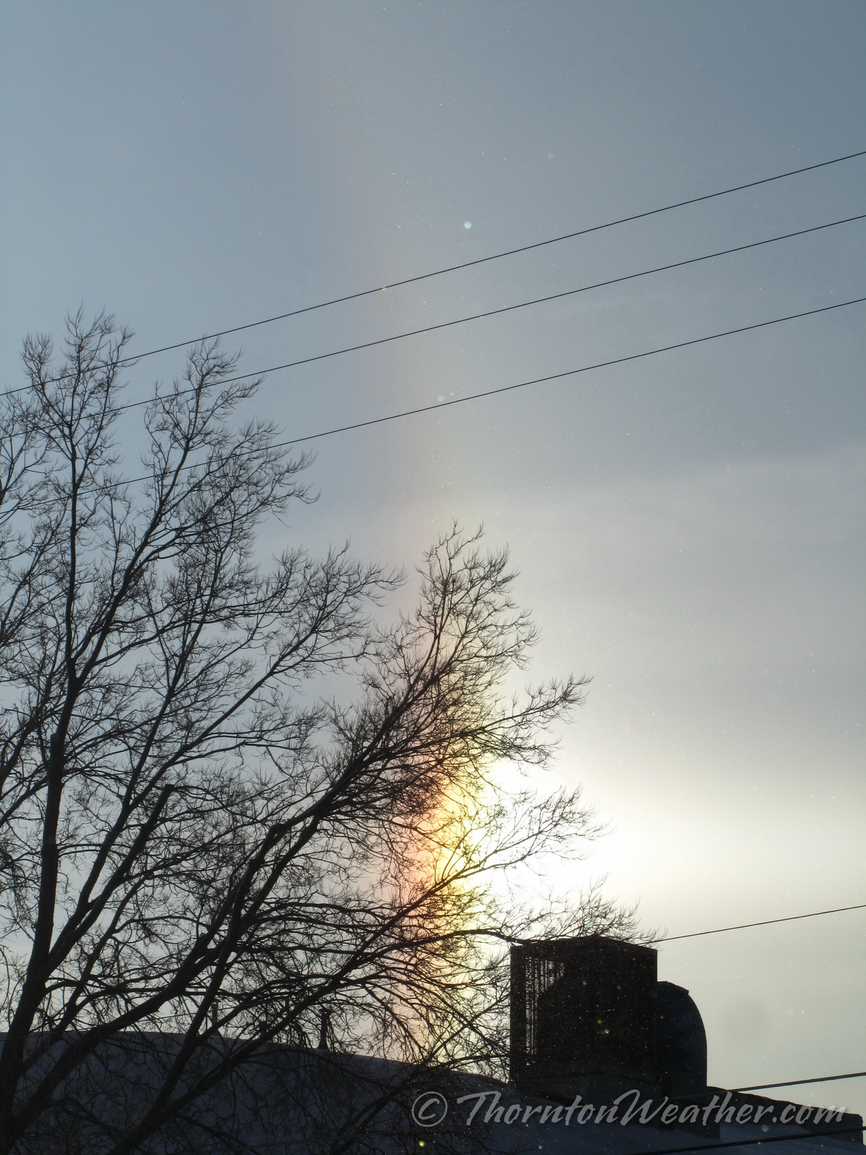
If you happened to look to the east at about 7:45 a.m. this morning you were treated to something pretty cool – a sun dog.
A sun dog is also called a ‘mock sun’, ‘phantom sun’ or ‘parhelia.’ These appear as bright spots to either side of the sun at the same distance above the horizon. They are caused by sunlight refracting through hexagonal ice crystals, usually in cirrus clouds. As the light hits the crystals, it is bent 22 degrees before reaching your eyes, thus creating the phenomena.
We took these images in north Denver.
February 5, 2014 – The full, bright sun dog. (ThorntonWeather.com)February 5, 2014 – The north ‘mock sun.’ (ThorntonWeather.com)February 5, 2014 – The south ‘mock sun.’ (ThorntonWeather.com)
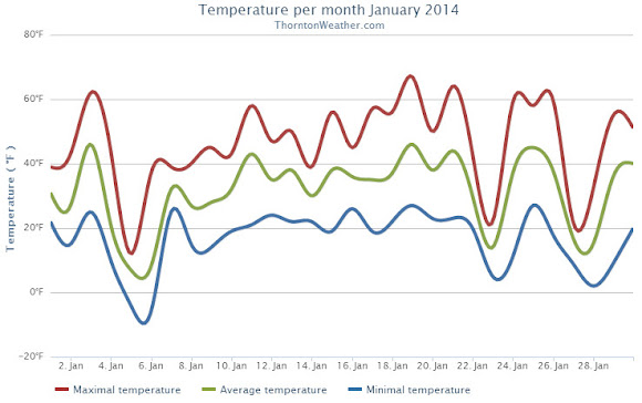
January 2014 could be remembered as a month that brought a weather rollercoaster. Looking back it seems as if we were constantly jumping between mild temperatures to cold to warmth and back to cold again.
The month started out cooler than normal for the first two days with a light shot of snow on New Year’s Day. Temperatures then shot into the 60s on the 3rd but were followed by colder temperatures and more snow on the 4th. On the 5th we registered our coldest day of the month.
From the 7th to the 16th we experienced relatively calm conditions and only very light snow on one day. We saw above normal temperatures from the 15th to the 21st. Two cold days followed with snow falling on the 23rd.
Alternating above-normal and below-normal temperatures closed out the month. Four of the last five days saw snowfall.
Thornton recorded an average monthly temperature of 31.3 degrees. This was slightly higher than Denver’s official recording of 31.2 degrees. Both were slightly above the historical average January temperature of 30.7 degrees.
Temperatures in Thornton ranged from a high of 67.0 degrees on the 19th down to a low of -5.5 degrees on the 6th. Denver’s warmest temperature of 65 degrees also occurred on the 19th and it recorded its coldest of -10 degrees on the 5th.
All 31 days of the month saw low temperatures below freezing in Thornton and four days saw high temperatures fail to reach 32 degrees. Two days saw readings below zero. Denver’s readings were similar with four days staying below freezing and three seeing lows below zero.
Precipitation for the month was nearly double of the Denver historical average thanks to snowfall that was about double of normal.
Thornton recorded 1.06 inch of liquid precipitation, well above the average of 0.41 inch. Denver saw a bit less with 0.94 inch.
While no major snowstorms were seen, there were plenty of smaller events. These gave Thornton 13.4 inches of the white stuff during the month, Denver saw 14.3 inches. Both were about double the January average of 7.1 inches. The official Denver measurement propelled January 2014 into the books as the 11th snowiest January on record.
Thornton, Colorado January 2014 temperature summary.Thornton, Colorado January 2014 precipitation summary.
CLIMATE REPORT
NATIONAL WEATHER SERVICE BOULDER, CO
517 AM MST SAT FEB 1 2014

...................................

...THE DENVER CO CLIMATE SUMMARY FOR THE MONTH OF JANUARY 2014...

CLIMATE NORMAL PERIOD 1981 TO 2010
CLIMATE RECORD PERIOD 1872 TO 2014

WEATHER         OBSERVED          NORMAL  DEPART  LAST YEAR`S
                 VALUE   DATE(S)  VALUE   FROM    VALUE  DATE(S)
                                          NORMAL
................................................................
TEMPERATURE (F)
RECORD
 HIGH              76   01/27/1888
 LOW              -29   01/09/1875
HIGHEST            65   01/19        76     -11       66  01/24
LOWEST            -10   01/05       -29      19      -12  01/12
AVG. MAXIMUM     44.9              44.0     0.9     44.6
AVG. MINIMUM     17.3              17.4    -0.1     16.0
MEAN             31.1              30.7     0.4     30.3
DAYS MAX >= 90      0               0.0     0.0        0
DAYS MAX <= 32      4               5.5    -1.5        6
DAYS MIN <= 32     30              29.4     0.6       30
DAYS MIN <= 0       3               1.7     1.3        5

PRECIPITATION (INCHES)
RECORD
 MAXIMUM         2.35   1883
 MINIMUM         0.01   1933
                        1934
                        1952
TOTALS           0.94              0.41    0.53     0.31
DAILY AVG.       0.03              0.01    0.02     0.01
DAYS >= .01         9               4.1     4.9        4
DAYS >= .10         3               0.9     2.1        1
DAYS >= .50         0               0.0     0.0        0
DAYS >= 1.00        0               0.0     0.0        0
GREATEST
 24 HR. TOTAL    0.26   01/30 TO 01/31           01/28 TO 01/29
                                                          01/29 TO 01/29
                                                          01/29 TO 01/29
 STORM TOTAL       MM                                 MM
 (MM/DD(HH))            MM                    01/29(00) TO 01/29(00)
                                                 01/29(00) TO 01/29(00)9
                                                 01/29(00) TO 01/29(00)9

SNOWFALL (INCHES)
RECORDS
 TOTAL             MM   MM
TOTALS           14.3               7.0

DEGREE_DAYS
HEATING TOTAL    1046              1063     -17     1067
 SINCE 7/1       3497              3531     -34     3300
COOLING TOTAL       0                 0       0        0
 SINCE 1/1          0                 0       0        0

FREEZE DATES
RECORD
 EARLIEST     09/08/1962
 LATEST       06/08/2007
EARLIEST                        10/07
LATEST                          05/05
..........................................................

WIND (MPH)
AVERAGE WIND SPEED              10.7
RESULTANT WIND SPEED/DIRECTION   4/230
HIGHEST WIND SPEED/DIRECTION    36/290    DATE  01/12
HIGHEST GUST SPEED/DIRECTION    44/280    DATE  01/12

SKY COVER
POSSIBLE SUNSHINE (PERCENT)   MM
AVERAGE SKY COVER           0.50
NUMBER OF DAYS FAIR           10
NUMBER OF DAYS PC             14
NUMBER OF DAYS CLOUDY          7

AVERAGE RH (PERCENT)     56

WEATHER CONDITIONS. NUMBER OF DAYS WITH
THUNDERSTORM              0     MIXED PRECIP               0
HEAVY RAIN                0     RAIN                       0
LIGHT RAIN                0     FREEZING RAIN              0
LT FREEZING RAIN          0     HAIL                       0
HEAVY SNOW                2     SNOW                       5
LIGHT SNOW               11     SLEET                      0
FOG                      11     FOG W/VIS <= 1/4 MILE      4
HAZE                      4

-  INDICATES NEGATIVE NUMBERS.
R  INDICATES RECORD WAS SET OR TIED.
MM INDICATES DATA IS MISSING.
T  INDICATES TRACE AMOUNT.
February in Colorado typically brings to an end an extended period when average temperatures are at their lowest. Winter begins to loosen its grip and temperatures get warmer but precipitation is not a particularly common event during the month.
Thanks to some late January snows, Denver’s seasonal snowfall has started to rebound but still remains below normal. February is only our sixth snowiest month so it may not provide much help on the precipitation month.
Temperatures however do usually see a nice rebound during the month. Average high temperatures climb from an average of 44 degrees at the start to 50 degrees by the end of February.
January 3, 2014 – Stunning wave cloud sunset as seen from Brighton. View more images in the slideshow below. (Brandi Donahue)
While typically a cold month, January is oftentimes lacking in terms of weather drama. Living in Colorado however provides plenty of opportunity to capture a wide variety of weather-related imagery as we see in our January 2014 slideshow.
Slideshow updated January 31, 2014
In this, our first monthly photo slideshow, we feature photos that not only we have taken but also those taken by ThorntonWeather.com fans.
Throughout the month we will gather the images sent to us via email or shared with us via our various social media outlets and post them in the slideshow below.
With us only being one week into the month, great photos of sunsets, wildlife, pets and wintry conditions have emerged. We love them all!
Thanks to a snowy start and a similarly snowy finish, the month of January 2014 climbed onto the list of top 10 January snow measurements in the Mile High City.
Officially the month ended with 14.3 inches of snowfall as measured at Denver International Airport. It was just enough to bump January 1991 from the number 10 spot (14.1 inches).
Here in Thornton we received just a bit less as we saw 13.4 inches of the white stuff.
January is only our fourth snowiest month with an average of 7.0 inches (based on 1981 to 2010 normals). The snowiest January on record occurred in 1992 when 24.3 inches of snow fell.
Looking at the 2013 / 2014 snow season, January helped make up some lost ground from the previous dry months.
The seasonal total now stands at 22.4 inches, 5.4 inches below the long term average of 27.8 inches we normally receive by the end of January. Thornton’s seasonal total is a bit better but still below normal at 24.2 inches.
The stage is set for Thornton to receive its most significant snowfall of the season thus far. Up in the high country snowfall will be measured in feet.
Here at lower elevations current forecasts are calling for 5 to 10 inches between Thursday and Friday afternoon. Many variables are in play that could affect the total that is eventually realized but this is certainly our best shot at a heavy snow thus far in the snow season.
We will be monitoring monitoring the storm very closely and posting regularly to our Facebook page and Twitter feed. You can follow along in real time below. We are also on Google+ here.
In a very brief period of time the forecast for the next 48 hours has changed considerably. The latest data indicates Thornton and the Colorado Front Range may be receiving a healthy dose of snow starting Thursday afternoon and lasting into Friday.
Abundant moisture streaming in from the Pacific coupled with a series of cold fronts stands to bring a wintry blast to the area. While the arrival is still a good ways out and much could change between now and when it gets here, the potential for a significant snow event exists.
The National Weather Service has issued a Winter Storm Watch for the Denver metro area and western plains. In effect from 3:00 p.m. Thursday through 3:00 p.m. Friday, the watch cautions that heavy snow will be possible.
Total forecast amounts are in the 3 to 6 inch range for the Denver area and 5 to 10 inches in the foothills. Bands of heavier snowfall are possible and could serve to drive those totals up. The Weather Prediction Center is giving at least a 40% chance of snowfall greater than or equal to 4 inches in our area.
The arrival later in the day Thursday should help to mitigate impacts to tomorrow’s commute home. However if this pans out as forecast, Friday morning’s drive to work may be a rough one.
With those forecast snowfall amounts comes the caveat that there is the possibility for less snowfall than mentioned above. A strong jet is overhead and while we expect upslope winds to help create a sustained snow event, should downslope flow prevail amounts will decrease.
A crew member works to remove snow from MetLife Stadium, which will host Superbowl XLVIII next month, on January 22, 2014 in East Rutherford, New Jersey. (Getty Images)
Mother Nature and the potential she has to impact Super Bowl XLVIII is a hot topic as the game draws nearer. No matter what happens in the contest between the Denver Broncos and Seattle Seahawks, it is almost certain the game will be the coldest NFL championship ever played and possibly the snowiest.
With the game still more than eight days away, weather forecasts are less than certain about what conditions will be on game day. However a look at historical statistics from the National Weather Service for the New Jersey / New York area provide some clues.
Using 1981 to 2010 climate averages, the normal high temperature for February 2 as measured at Newark is 40 degrees. The average low is a chilly 25 degrees.
The coldest kickoff temperature in Super Bowl history occurred on January 16, 1972. Played at Tulane Stadium in New Orleans, the temperatures at the start of that game was a chilly 39 degrees on the field.
Given that, it is pretty certain this will be the coldest Super Bowl in history. It could also be the first to have snow fall on the field and freezing rain and wind are other hazards the teams may have to contend with.
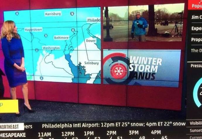
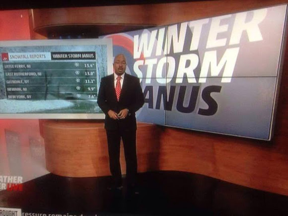
The Weather Channel’s naming of storms has never been a good idea. Now we see another reason why when a letter appears to be missing from this storm’s name. Click for a larger view.
Last year the Weather Channel unilaterally decided to start naming winter storms, a decision met with ridicule and concern from weather professionals. Now, with a storm TWC calls ‘Janus’, we very graphically can see another reason why the naming of these storms may not be a good idea.
The list the Weather Channel created for winter storms during the 2013 – 2014 season range contains everything from Latin words and Roman governors to mythological figures.
The channel is calling the current storm pounding the Northeast ‘Janus.’ Janus comes from Roman mythology and was considered the god of beginnings and transitions.
Setting aside the fact the naming of winter storms is ridiculous and only serves to confuse people in potentially dangerous situation, the display of the name during broadcasts has brought further ridicule.
Many graphics showing the word ‘Janus’ on TWC were partially obscured by their on air personalities and even their own imagery. The end result has been the appearance of the name without the ‘J’.
The Weather Channel’s naming of storms has never been a good idea. Now we see another reason why when a letter appears to be missing from this storm’s name.
Weather, natural disasters & climate news and information.


 February in Colorado typically brings to an end an extended period when average temperatures are at their lowest. Winter begins to loosen its grip and temperatures get warmer but precipitation is not a particularly common event during the month.
 Thanks to a snowy start and a similarly snowy finish, the month of January 2014 climbed onto the list of top 10 January snow measurements in the Mile High City.
 The stage is set for Thornton to receive its most significant snowfall of the season thus far. Up in the high country snowfall will be measured in feet.
 In a very brief period of time the forecast for the next 48 hours has changed considerably. The latest data indicates Thornton and the Colorado Front Range may be receiving a healthy dose of snow starting Thursday afternoon and lasting into Friday.