
|
Taiwan has evacuated thousands of residents and tourists as “super typhoon” Dujuan headed towards the island, gathering strength on its approach to the east coast. Torrential rains and high winds are forecast across Taiwan from Monday afternoon, with landfall predicted around 15:00 GMT. Almost 3,000 people, most of them tourists, were evacuated on Sunday from Taiwan’s… Continue reading Taiwan evacuates thousands as ‘super typhoon’ nears |
Supermoon eclipse provides rare celestial event Sunday
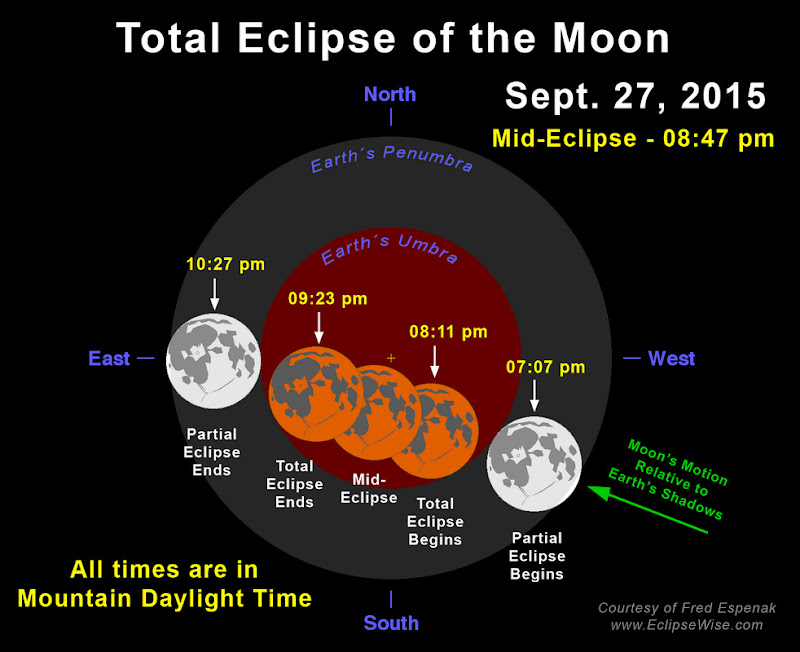
A total lunar eclipse coupled with a ‘supermoon’ will bring a very unusual scene to the sky on Sunday. Taken separately, the two events are not quite as extraordinary or rare. However, this will be the first time in 33 years they have occurred at the same time and the last for another 18 years.
The moon’s orbit around Earth is not a perfect circle and when it is at its closest to us, it appears quite a bit larger to our eye – hence the name ‘supermoon.’
On Sunday it will be about 31,000 miles closer to Earth than it is at its farthest point. According to NASA, this results in it appearing to be about 14% larger and 30% brighter.
The total lunar eclipse will be our second of 2015 and fourth in the past two – a tetrad of eclipses. During these, the moon finds itself in the Earth’s shadow and without direct sunlight hitting its surface, the moon turns an eerie orange / red color – a ‘blood moon.’
The last time these two events coincided was in 1982 and the next time won’t be until 2033. As NASA scientist Noah Petro said, “That’s rare because it’s something an entire generation may not have seen.”
When and where to watch?
The partial eclipse begins at 7:07pm MDT on Sunday, September 27, 2015 with totality starting at 8:11pm. The moon will then be completely eclipsed for a little more than an hour with mid-eclipse at 8:47am. The waning partial eclipse will end at 10:27pm.
One catch for viewing the entire event here along the Front Range is that when it begins, the moon will actually be just starting to rise on the eastern horizon. However, at mid-eclipse the moon will be 21 degrees above the horizon to the east southeast providing a nice view not far above the landscape.
Anyone in the area with a clear view of the lower, eastern sky should have no problem viewing the event.
Will Mother Nature cooperate?
Our unseasonably warm temperatures will be continuing through the weekend so there are no concerns about it being too cold to go outside. Clouds, however, are something to watch closely for. Some atmospheric moisture is expected late in the day Sunday and it is possible cloud cover may impact the clear viewing.
On the day of the eclipse, check our hour-by-hour outlook for the latest sky cover forecast.
What is the ‘blood moon’ and tetrad?

During totality, the moon will be rendered orange / red as the Earth’s shadow envelops the moon. Many are calling this a ‘blood moon’ but the meaning behind that term isn’t exactly clear.
As written on EarthSky.org, some attribute it to the lunar tetrad – four successive full lunar eclipses without any partial eclipses. Tomorrow morning’s eclipse is the second in the lunar tetrad with each full lunar eclipse coming six months apart.
The blood moon as it pertains to these eclipses should not be confused with the October full moon which is also referred to as a blood moon in folklore.
Fall Foliage 2015: Top spots to view the colors near the Front Range

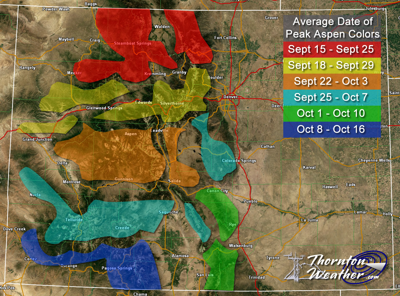
This time of year many folks head to the hills west of Denver in search of gold – fall foliage gold.
This year the changing of the colors seems to be a bit spotty and an early freeze last fall followed by a late freeze this spring has impacted the overall quality of the show. That certainly is not to say there isn’t some absolutely gorgeous spots out there.
Where to go? Below are five of ThorntonWeather.com’s favorite ones near Denver – plus a few further out and some bonus ideas. After that, we will tell you where you can find a great website that provides regular updates on viewing conditions.
I-70 Corridor – If you’re looking for the easiest route, then this one is for you. Simply head west on I-70 about 110 miles to Avon. Between Vail and Avon, both sides of I-70 are lined beautifully with aspen.
Rocky Mountain National Park – One of the most popular summer destinations in the state is of course also a prime spot to view aspen in all their glory. Once in the park head toward Bear Lake. Glacier Gorge Junction provides a beautiful spot and you of course also get to enjoy all the splendor that Rocky Mountain National Park has to offer. Extend your viewing by taking Trail Ridge Road all the way through to the west side of the park and the Grand Lake and Granby area.
Peak to Peak Highway – This little road trip can be a dual purpose trip – gambling and fall foliage viewing! Take U.S. 6 through Clear Creek Canyon and then 119 through Blackhawk and Central City. You can of course stop there if your wallet is fat enough and donate some money to the casinos. From there continue on 119 toward Nederland. Take highway 72 toward Ward and Allenspark. There you will find more golden aspen than you can imagine, all with the Continental Divide nearby.
Poudre Valley Canyon – Heading north on I-25 take Colorado 14 west and into Poudre Canyon and Roosevelt National Forest. As you continue west you will come very near timberline as you come to Cameron Pass. Amazing views abound!
Guanella Pass – This is a nice, relatively short drive from Denver. From C470 take 85 through Bailey and Conifer, a nice drive unto itself. When you come to the town of Grant, take the Guanella Pass Scenic and Historic Byway north to Georgetown. The air is pretty thin along the way as you climb in excess of 11,500 views through the Pike and Arapahoe National Forests. Fair warning – about 10 miles of the road is gravel but it is well maintained.
A couple other possibilities further from the Front Range:
Leadville / Aspen – From Denver take I-70 west to Copper Mountain and then Colorado 91 south over Freemont Pass to Leadville. Along the way there are plenty of viewing opportunities and Leadville is a nice little town to make a stop. From here you can take Highway 24 north back through Minturn and Vail. To extend the drive, take Highway 24 south to Colorado 82 and head toward Aspen. You can stop by the Maroon Bells in White River National Forest to view some of the most photographed mountains in Colorado.
Cottonwood Pass – From Denver take Highway 285 to Buena Vista. Head west on Main Street for seven miles then west on County Road 344 / Colorado 82. From there you start the climb up Cottonwood Pass with absolutely stunning views from the top. If you are up for it, you can continue down the west side of the pass into the Taylor Park area. Be forewarned though that the western half of the pass is unpaved and twisty.
Honorable mentions worth considering:
- Boreas Pass between Breckenridge and Como (County Road 10)
- Kenosha Pass on Highway 285 between Bailey and Fairplay
- Independence Pass (Colorado 82 between Aspen and Twin Lakes)
- Colorado 103 from Evergreen to Echo Lake. Throw in a drive up Mount Evans for a bonus.
If you do head out, be sure to send us your pictures for inclusion in our monthly photo slideshows!
- Email: info@ThorntonWeather.com
- Facebook: https://www.facebook.com/ThorntonWeather
- Google+: https://plus.google.com/+Thorntonweather
- Twitter: @ThorntonWeather (https://twitter.com/thorntonweather)
For more information:
Denver breaks 130 year old high temperature record for September 21
 With only a couple of days left in summer, Mother Nature seems to be indicating the season won’t go down without a fight. Denver broke a high temperature record today that has been on the books for more than a century.
As officially recorded at Denver International Airport, the high temperature today topped out at 89 degrees. This bests the old record for the date of 88 degrees set in 1885 and is well above the average for today’s date of 77 degrees.
Here in Thornton we were only minutely cooler with a high of 88 degrees today.
Looking ahead, we do expect to see some cooling in the days ahead. However, temperatures are expected to remain above normal through at least the weekend. Get the extended forecast here.
September 20 to September 26: This week in Denver weather history
Looking back at this week in Denver history we start to see more of the signs that summer is coming to an end and fall and winter are right around the corner. Summer-like severe weather can still occur but we also start to see more cold temperatures and occasions with snow become more prevelant.
From the National Weather Service:
20
In 1921…an apparent Bora produced northwest winds sustained to 44 mph with gusts to 64 mph.
In 1955…hail stones 1/2 to 3/4 inch in diameter were reported across parts of the city of Denver.
In 1992…weather observers at Buckley Air National Guard base sighted two tornados southeast of the base. The tornados were short-lived and caused no injuries or damage.
20-21
In 1963…heavy rain and hail caused local flooding in southeast Denver. Thunderstorm rainfall was only 0.60 inch at Stapleton Airport on the 20th.
In 1983…the cold front on the 19th brought an unusually cold air mass into metro Denver for so early in the season. The temperature dipped to a daily record minimum of 28 degrees on both days.
In 1995…a vigorous late summer storm brought the season’s first heavy snow to portions of metro Denver. Millions of trees were damaged and power lines downed as 4 to 8 inches of heavy wet snow settled on fully leafed trees in the Boulder and Denver areas. Branches snapped and trees split under the weight of heavy snow…downing power lines. Firefighters responded to numerous transformer fires. Around 100 thousand people were left without electricity in Boulder and Denver areas alone. It took over a week to fully restore power to some areas. Insurance claims were estimated to be around 6 million dollars to homes in metro Denver and about 500 thousand dollars in damage to automobiles. It was estimated that about 80 percent of 125 million dollars worth of city owned trees in Denver were damaged. Snowfall totaled 7.4 inches at the site of the former Stapleton International Airport where the greatest depth of snow on the ground was only 4 inches due to melting. Temperature records were set on the 21st when the thermometer dipped to a record low reading of 27 degrees and climbed to a high of only 36 degrees… Setting a record low maximum for the date. North winds gusted to 29 mph at Denver International Airport on the 20th.
20-22
In 1902…a thunderstorm on the 20th…in advance of an apparent cold front…produced rain…hail…and northwest winds to 40 mph with gusts to 48 mph. Widespread rain developed behind the cold front and totaled 3.21 inches from the evening of the 20th through the early afternoon of the 22nd. The 2.70 inches of precipitation recorded from 800 pm on the 20th to 800 pm on the 21st is the greatest 24 hour precipitation ever recorded in the month of September. The temperature dipped from a high of 80 degrees on the 20th to a high of only 51 degrees on the 21st.
21
In 1951…4.2 inches of snow fell at Stapleton Airport… Where northeast winds gusted to 27 mph. This was the first snowfall of the season in Denver…marking the end of the second shortest snow-free period on record…109 days…from June 4th through September 20th. A trace of snow fell on June 3rd.
In 1984…thunderstorm winds gusted to 56 mph at Stapleton Airport.
In 1992…the only precipitation of the month at Stapleton International Airport…0.01 inch of rain…fell from a brief shower around daybreak.
21-22 in 1870…strong winds occurred in the foothills and in Boulder and Denver.
In 1895…rain changed to snow overnight and totaled 11.4 inches in downtown Denver. This was the first snowfall of the season and the second heaviest first snowfall of the season on record. North winds were sustained to 27 mph with gusts to 30 mph on the 21st.
In 2009…an early season storm brought moderate to heavy snow to the foothills of clear creek…Jefferson and Park counties…west and southwest of Denver. A trained spotter…4 miles west-northwest of Conifer… Was the big winner with 14 inches of snow. Storm totals elsewhere generally ranged from 5 to 10 inches.
22
In 1913…a thunderstorm produced northwest winds sustained to 40 mph with gusts to 44 mph.
In 1946…a trace of snow fell in downtown Denver. This marked the start of the longest snow season on record… 263 days through June 11…1947…when a trace of snow also fell.
23
In 1873…north to northwest winds blowing almost a gale spread clouds of dust and sand into the city during the afternoon and evening. From the roof of the weather observer’s building…houses a few hundred yards away were not visible and not even the sky could be seen through the clouds of sand. The wind reached sustained speeds of 35 mph…but only 28 mph was registered for any one hour.
In 1977…wind gusts from 50 to 80 mph were reported along the foothills. A northwest wind gust to 53 mph was recorded at Stapleton International Airport.
23-24
In 2000…the first snowstorm of the season brought heavy snow to areas in and near the foothills. While the heaviest snow fell north of metro Denver…6 inches were measured in Boulder…4 inches at both Castle Rock and Morrison…but only 0.2 inch at the site of the former Stapleton International Airport where most of the precipitation fell as rain. At Denver International Airport where drizzle and rain fell on the 23rd… Snowfall during the early morning of the 24th was estimated at 2.1 inches due to melting. The foothills west of Denver received more snow with 10 inches measured at Conifer…9 inches 11 miles southwest of Morrison… 8 inches atop Crow Hill…7 inches at Chief Hosa…and 5 inches at Ralston Reservoir.
24
In 1901…northwest winds were sustained to 50 mph with gusts as high as 57 mph in the city.
In 1932…thunderstorm rainfall of only 0.11 inch was the only measurable precipitation for the month that year in the city.
In 1986…a very strong wind storm roared across metro Denver. Boulder was hit hardest. Winds peaked to 131 mph at the National Center for Atmospheric Research. This is thought to be the highest wind gust ever recorded in Boulder during September. A wind gust to 118 mph was clocked on Davidson Mesa and to 92 mph near Niwot. Gusts of 70 to 80 mph were common over all of Boulder where an estimated 70 to 90 large trees were uprooted. About a dozen of them hit cars. Two walls of a building under construction were toppled and solar panels were blown off a house. Traffic lights and power lines were downed. Damage to power equipment alone was estimated at 100 thousand dollars. Wind gusts to 87 mph at Jefferson County Airport damaged two planes. A woman was seriously injured in Boulder. She suffered a fractured skull when struck by a falling tree limb. Trees were also downed in Louisville and Lafayette. West wind gusts to 45 mph were recorded at Stapleton International Airport.
25
In 1873…a fire was sighted in the woods near Platte Canyon… Probably caused by high winds blowing sparks among the timber.
In 1896…an apparent cold front produced northeast sustained winds to 40 mph with gusts to 48 mph.
In 1910…a thunderstorm produced sustained north winds to 51 mph. This was the highest recorded wind speed in the city in September at the time.
In 1936…a vigorous cold front produced a deadly dust storm in the city. North winds sustained to 36 mph with gusts to 38 mph produced much blowing dense dust…greatly restricting the visibility. The temperature plunged from a high of 84 degrees to a low of 38 degrees by midnight. The weather observer described the event with the following. “at 6:00 pm the temperature was 82 degrees and the wind velocity was only 4 mph; but with the wind shifting to the north and the barometer rising quite rapidly…the temperature fell sharply. By 6:30 pm…the wind velocity increased rapidly and by 7:00 pm had reached a maximum sustained velocity of 36 mph…bringing with it clouds of dust which had been picked up by gale force winds in southern Wyoming and northern Colorado…covering the city. The visibility was generally reduced to about 1/4 mile; however…the whirling of the dust down the streets and alleys…the visibility was at times somewhat less. Airplanes were grounded…traffic was halted at times…and homes filled with dust. The strong winds damaged electric power and telephone lines…leaving homes in darkness for a few hours in the city and for 18 hours in suburban towns and putting 2500 telephones out of service because of broken lines. An electric lineman was killed while repairing damage by the high winds. The dust storm was followed by rain that began falling at 10:55 pm…which turned to snow during the early morning hours of the 26th. A major snow storm followed on the 27th through the 29th.”
In 1999…high winds developed in the foothills of Boulder County. Winds gusted to 90 mph at Wondervu.
25-26
In 1908…apparent post-frontal rain changed to snow overnight and totaled 6.5 inches in downtown Denver. This was the first snow of the season. Precipitation totaled 0.76 inch. North winds were sustained to 39 mph on the 25th.
25-27
In 1996…an early season snowstorm brought heavy snow to the Front Range eastern foothills. Snowfall totals included: 8 to 12 inches around Conifer…7 inches on Floyd Hill…and 6 inches at both bailey and Chief Hosa. Snowfall totaled only 4.7 inches at the site of the former Stapleton International Airport. This was the first measurable snow of the season. After the passage of a strong cold front…north winds gusted to 38 mph at Denver International Airport on the 25th.
26
In 1907…a late afternoon thunderstorm produced hail…0.23 inch of precipitation…and north winds sustained to 24 mph.
In 1927…snowfall of 1.7 inches…mixed at times with sleet… Was the first measurable snowfall of the season.
In 2012…a man was seriously injured when he was struck by lightning outside the Hebrew Educational Alliance as he and his family were getting in their car. The victim stopped breathing but was saved when his wife performed cardiopulmonary resuscitation on him immediately following the lightning strike. He suffered burns to 15 percent of his body which included his legs…chest… Abdomen and neck. Lightning also caused 48 outages in Denver which affected 6582 Xcel Energy customers.
26-28
In 1936…the heaviest snowfall ever recorded in September and the heaviest snowfall ever recorded so early in the season dumped a total of 16.5 inches of snow on downtown Denver and 21.3 inches at Denver municipal airport. The 15.0 inches of snow measured from 6:00 pm on the 27th to 6:00 pm on the 28th is the greatest 24 hour snowfall ever recorded in September. This was the first snow of the season. The snow was intermittent through the 26th…but continuous from early afternoon on the 27th to around midnight on the 28th…except for a period of rain during the afternoon of the 28th which contributed to a loss of depth on the ground. The greatest snow depth on the ground downtown was 13 inches with 8 inches at Denver municipal airport. There were no high winds with the storm and traffic was interrupted for only a short period. The storm produced property damage estimated at 7 million dollars. With trees and shrubs in full foliage…the leaves caught and held the heavy water-laden snow…until the branches snapped from the weight. More than 3000 workmen were called to remove the debris and snow from the city. The city firemen who were off duty…as well as all the reserves… were asked to report to their stations. All schools in the city remained open…but attendance was only 50 percent of normal. Grade school students were sent home at noon on the 28th. The early storm caught stockmen with many cattle still in higher ranges. Warm weather followed the snow…which had all melted by the end of the month…except for a few inches in sheltered places.
Chile declares state of emergency after quake
|
Santiago (dpa) – The Chilean government declared a state of emergency in a central region Thursday after a magnitude-8.3 earthquake killed 11 people and caused widespread disruption. President Michelle Bachelet declared the state of emergency for the region around the port city of Coquimbo, near the epicentre of the quake which struck late Wednesday, daily El… Continue reading Chile declares state of emergency after quake |
Five dead and hundreds homeless in California wildfires
|
Los Angeles (dpa) – California authorities recovered the bodies of four more people killed in wildfires raging in the central part of the state, bringing the death toll to five, officials said Thursday. The remains of four men who died separately in the Valley fire, north of San Francisco, and the Butte fire, south-east of the… Continue reading Five dead and hundreds homeless in California wildfires |
State of emergency declared: 23,000 displaced in California wildfires
|
Around 23,000 people have been displaced and a state of emergency declared in California as wildfires rage in the north of the US state. An elderly, disabled woman is known to have died as flames consumed her building when the fires erupted on Saturday (September 12). Others, such David Clark, managed to flee. He spoke from… Continue reading State of emergency declared: 23,000 displaced in California wildfires |
Shedding light on the rare Sept. 27 supermoon eclipse
|
Ashley Morrow, NASA Goddard Space Flight Center Coming soon for the first time in more than 30 years: you’ll be able to witness a supermoon in combination with a lunar eclipse. Late on Sept. 27, 2015, in the U.S. and much of the world, a total lunar eclipse will mask the moon’s larger-than-life face for more… Continue reading Shedding light on the rare Sept. 27 supermoon eclipse |
At Least 6 Dead In Southern Utah Flash Flood
|
At least six people were dead and several others were missing after heavy rains in southern Utah triggered flash flooding, authorities said Monday night. Those missing are reportedly from Colorado City and Hildale area, near the Utah-Arizona border. Hildale officials reportedly said that a flash flood washed two vehicles off the road at Canyon Street and… Continue reading At Least 6 Dead In Southern Utah Flash Flood |