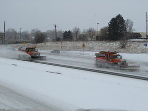
CDOT snowplows work on I-25 near 104th Avenue Monday afternoon. Arctic cold will be a major hazard as wind chills could dip to 35 degrees below zero over the next 36 hours. (ThorntonWeather.com)
Storm update, 4:30pm – The thermometer only knows one way through the rest of today and tonight – down! Thus far Thornton has dipped to 6 degrees with wind chill values around -3 and it is far from done dropping.
In terms of snow we will continue to see a pretty steady stream of light snowfall through the extended period but accumulations will be light. Most areas will see a couple inches additional accumulation with higher amounts south and west in the foothills and along the Palmer Divide.
For all the latest, follow us on Twitter and join us on Facebook
The cold continues to be the real story. Temperatures overnight will be dropping to five below zero with some places possibly getting even colder. Couple the cold air with gusty winds to 25 mph and wind chill readings will be between 15 and 35 degrees below zero.
These temperatures will be very dangerous for anyone caught outside in the cold. Hypothermia and frostbite can settle in very quickly and everyone needs to be aware.
Roads continue to be icy and snowpacked and the afternoon and morning rush hour are going to be rough around the metro area. Drivers should exercise extreme caution.
All Thornton area school districts have announced they will be closed on Tuesday including Adams 12, Adams 14, Adams 50, Mapleton, and Brighton 27J.
A Winter Weather Advisory will go into effect at 6:00am on Monday as snow and bitter cold arrive. (ThorntonWeather.com)
A major winter storm is set to impact nearly two thirds of the nation starting tomorrow including Thornton and the rest of northeastern Colorado. The National Weather Service has issued a Winter Weather Advisory for our area warning of blowing snow and dangerous cold.
For all the latest, follow us on Twitter and join us on Facebook
The service is warning of total snow accumulations of 3 to 7 inches for the event from tomorrow morning through Tuesday. Snow is expected to start lightly on Monday morning then increase in intensity in the afternoon and continue overnight into Tuesday morning.
Arctic cold will be a prominent feature of this system sending the mercury plummeting into areas that present a very real danger to people and property. Monday will see temperatures at about 26 degrees at 6:00am but then decreasing continually throughout the day and overnight when it will drop below zero.
Tomorrow’s afternoon commute and the Tuesday morning commute are likely to be rough ones so you will want to plan accordingly.
Tuesday’s high temperature will struggle to even get above zero and overnight temperatures on Tuesday could drop all the way to 15 degrees below zero. Wednesday will warm only slightly with highs of around 10 degrees.
To say today’s snowstorm was a fast mover doesn’t do it justice. The storm hit fast and furious and many doubted our forecasts for only light snowfall. But, as quickly as it arrived the winter storm departed and the event was over by nightfall.
In a span of three hours or so Thornton received 1.2 inches of snow. Of course it is a bummer to have to withstand the traffic problems caused by a storm that brought so little. To top it off we now have to wash our cars which hadn’t been clean but for a few days. Not much return for the hassle, even if we need the moisture. 🙂
The time lapse video below captures the entire event from start to finish and does it in about 9 seconds.
ThorntonWeather.com's new satellite imagery allows a close in, bird's eye view of the weather.
For more than four years ThorntonWeather.com has been the one and only source for truly local weather for Thornton, Colorado. We are continually improving the site to provide more information and now we have greatly enhanced two of our most popular features.
First up and arguably the most exciting is the satellite imagery. Using imagery provided by NOAA you begin by selecting a region – northeastern Colorado for a look close to home or perhaps a look at the entire United States. Once you go there, you are given an animated display powered by Adobe Flash.
Best of all with the new satellite system is a series of overlays that you can select using the boxes above the satellite image. You can add the county outlines, major highways, and even weather conditions (the selections vary depending on the region). For each region you can also select an enhancement. These different color palettes are useful for spotting wildfires, the most significant areas of a storm and more.
You can access the satellite imagery by going to Radar & Maps on the menu on the left then select “Satellite Imagery.”
Last but not least is a revamped radar display system. The radar is now fully animated like the new satellite which gives you much greater control. You can speed up the animation, slow it down and pause the display, all of which are useful to seeing where the weather is headed. You can even zoom in on a spot on the display.
To access the radar go to Radar & Maps on the menu on the left and select “TW Super Doppler Radar.”
We recently sat down and talked with YourHub about ThorntonWeather.com. (YourHub)
One thing we at ThorntonWeather.com never get tired of talking about is the weather. We recently sat down with the Denver Post’s YourHub and talked to them about our experiences with weather and of course ThorntonWeather.com itself.
Journalist Joey Kirchmer and Photojournalist Kristin Morin have done a fine job telling the story about ThorntonWeather.com and we were glad to talk to them.
As we have always said, we provide ThorntonWeather.com as a service to the community and view it as a means to inform, educate and share our passion for the weather. Of all the places in the world, Colorado provides one of the most dynamic weather environments and it truly is an interesting place in terms of weather.
Snow now covers nearly three quarters of the lower 48 states and 47 of the 48 have at least some snow. (NOAA)
For much of the lower 48 states of the United States the 2010 to 2011 winter season has been a rough one. Blizzards and snowstorms have stretched into the Deep South and this morning data shows that nearly three quarters of the nation is covered in snow.
The latest analysis from NOAA’s National Operational Hydrologic Remote Sensing Center shows 69.4% of the lower 48 states covered in snow as of this morning. This is a significant increase over the 33.1% cover seen in December and bests the previous snow season’s highest number.
Perhaps most interesting is that 47 of the lower 48 states and 49 of all 50 states including Hawaii have at least some snow with the only exception being Florida. Even the Deep South reaching nearly to the Gulf of Mexico is covered in a blanket of white today after ice and snow pummeled the region yesterday. Early this morning only five of the 48 did not have some sort of a winter weather warning or advisory in effect.
Not since the 1888 to 1889 snow season has Denver seen less snow this far into the snow season than this year.
Amid record-setting snowfall in northern Europe this winter and blizzards on the U.S. East Coast, one place that normally sees its fair share of snow has been left high and dry. The Mile High City is facing a snow drought of near record proportions having thus far experienced its worst snow season in 122 years.
Denver’s snow season is from July through June and through the end of December Denver has recorded a mere 4.8 inches of snow. The majority of that (3.3 inches) was received from a pre-New Year’s storm on December 30th. Here in Thornton we have fared a mere 0.1 inch more snow for a total of 4.9 inches.
On average the city sees 25.6 inches from July through December and the pitiful show so far gives the 2010 to 2011 season a 20.8 inch snow deficit to date. Only one other time in the 128 years that snow records have been kept in Denver has so little snow been recorded to this point in the season.
One has to look back to the 1888 to 1889 season to find a more dismal snow season. It was that season 122 years ago that 3.8 inches of snow had been recorded by the end of December. The next worst season up to December was two seasons later when 5.5 inches was recorded.
2010 was a relatively uneventful year for weather in Thornton.
Many years in Colorado are marked by significant weather events. The Christmas Blizzards of 2006, the severe thunderstorms that dominated June of 2009 or reaching even further back the Thornton Tornado of 1981. The same can’t entirely be said about 2010 as we experienced a relatively quiet year without any truly major events.
In terms of temperatures the year was slightly warmer than the historical average of 50.1 degrees. In 2010 Denver officially recorded an annual average of 51.2 degrees at Denver International Airport. Thornton was actually spot on Denver’s historical average at 50.1 degrees.
Denver temperatures ranged from a high of 102 degrees on July 17th down to -16 on January 7th. The July high was a record for the date but the January low didn’t fall far enough to set a record. Thornton’s high temperature for the year was 101.6 degrees and our low was -9.7 degrees – both occurring on the same dates as Denver’s.
The average high temperature for the year was 65.3 degrees – 1.1 degrees above normal. The average low was 37.0 degrees, 1.2 degrees above normal. Thornton’s average highs and lows were very close to Denver’s at 65.7 degrees and 36.8 degrees respectively.
DIA reported 47 days with temperatures at or above 90 degrees – 16 above normal. Thornton stayed cooler recording only 38 days. Low temperatures dipped below freezing on 158 days in Denver (2 above normal) while Thornton had one more with 159 days.
Snowfall
The first half of the 2010 to 2011 snowfall season was dismal as Denver recorded a mere 4.8 inches and Thornton recorded 4.9 inches. This is the second lowest total on record for the period with the only year with less snow being 1888 when 3.8 inches was recorded.
2010 Year in Review - A month by month narrative from the National Weather Service.
While Denver’s weather in 2010 was generally pretty quiet that isn’t to say there wasn’t something to talk about. Below is a month by month narrative from the National Weather Service for each month of the year.
JANUARY…ONLY A TOTAL OF 0.07 INCH OF LIQUID EQUIVALENT WAS COLLECTED DURING JANUARY 2010 WHICH CAME FROM MELTED SNOWFALL. THIS IS 0.44 INCH BELOW THE NORMAL OF 0.51 INCH. IT ALSO TIED 1961 AS THE 6TH DRIEST JANUARY SINCE DENVER RECORDS KEEPING BEGAN IN 1872. ONLY 2 DAYS RECORDED MEASURABLE MOISTURE WITH THE 6TH COLLECTING THE MOST IN A 24 HOUR PERIOD WITH ONLY 0.05 INCH. IN THE SNOWFALL DEPARTMENT WHERE MEASUREMENTS ARE TAKEN NEAR THE DENVER INTERNATIONAL AIRPORT (DIA)… ONLY 2.6 INCHES OF THE WHITE STUFF WAS RECORDED. THIS AGAIN WAS BELOW THE JANUARY NORMAL OF 7.7 INCHES. FOR THE SEASON…THE GOOD NEWS IS THAT THE JULY THROUGH JANUARY’S SEASONAL TOTAL WAS 40.2 INCHES WHICH IS 6.9 INCHES ABOVE THE NORM OF 33.3 INCHES FOR THAT PERIOD OF TIME. 40.2 INCHES IS FAR BETTER THAN THE 2008-09 SEASONAL TOTAL THROUGH JANUARY OF A MERE 16.9 INCHES. THERE WERE NO PRECIPITATION RECORDS SET OR TIED DURING THE MONTH.
JANUARY 2010 TEMPERATURE STATISTICS TURNED OUT TO BE A NON-HEADLINE. THE MONTH FINISHED WITH AN AVERAGE TEMPERATURE OF 30.4 DEGREES WHICH IS 1.2 DEGREES ABOVE THE 29.2 NORMAL. TEMPERATURES RANGED FROM A HIGH OF 58 DEGREES DOWN TO A LOW OF A NON-RECORD -16 DEGREES. IN FACT… THERE WERE NO TEMPERATURE RECORDS SET OR TIED DURING JANUARY 2010. ALL 31 DAYS HAD LOW TEMPERATURES AT OR BELOW FREEZING AND 3 DAYS HAD MINIMUM TEMPERATURES BELOW ZERO. TWO DAYS HAD HIGH MERCURY READINGS AT OR BELOW FREEZING. JANUARY 2009 SEEMED LIKE A COOL MONTH AS THERE WERE ONLY 7 READINGS THAT REACHED INTO THE FIFTIES. OBVIOUSLY THE REST OF THE MONTH ONLY SAW READINGS IN THE 40S OR BELOW.
THREE DAYS HAD DENSE FOG (VISIBILITY OF 1/4 MILE OR LESS) RECORDED AT DIA. LIGHT FOG WAS OBSERVED ON 8 DAYS. THE PEAK WIND DURING THE MONTH WAS A FAIRLY LIGHT GUST OF 35 MPH FROM A NORTHWESTERLY DIRECTION (310 DEGREES).
FEBRUARY…IT WAS A COOL FEBRUARY WITH THE MONTH FINISHING WITH A 29.1 DEGREE AVERAGE TEMPERATURE WHICH WAS 4.1 DEGREES BELOW THE NORMAL OF 33.2 DEGREES. EVEN THOUGH IT WAS 4.1 DEGREES BELOW NORMAL…IT WAS STILL 3.9 DEGREES BELOW THE 10TH COLDEST FEBRUARY WHICH WAS 25.2 DEGREES ESTABLISHED IN 1905. THE COLDEST FEBRUARY OCCURRED IN 1954 WITH A VERY FRIGID 17.6 DEGREE AVERAGE. THE FEBRUARY AVERAGE OF 29.1 DEGREES WAS COLDER THAN THE JANUARY 2010 30.4 DEGREE AVERAGE. TEMPERATURES DURING FEBRUARY RANGED FROM A HIGH OF 52 DEGREES ON THE 27TH DOWN TO A LOW OF -1 DEGREE ON THE 9TH. ONLY 3 DAYS DURING THE MONTH REGISTERED HIGHS IN THE 50S. ALL 28 DAYS REGISTERED OVERNIGHT LOW TEMPERATURES AT OR BELOW FREEZING WITH 8 DAYS WHEN THE HIGH TEMPERATURE DID NOT REACH ABOVE 32 DEGREES. ONLY 1 LOW TEMPERATURE DIPPED BELOW ZERO.
PRECIPITATION WAS ALSO BELOW NORMAL. THE MONTH FINISHED WITH ONLY 0.30 INCH OF LIQUID WHICH WAS MEASURED FROM WATER EQUIVALENT OF SNOW. THIS EQUATED TO 0.19 INCH BELOW THE NORMAL OF 0.49 INCH. NINE DAYS RECORDED MEASURABLE MOISTURE BUT THERE WAS NO DAYS THAT ACCUMULATED .10 INCH OR MORE. THE MAXIMUM 24 HOUR LIQUID MEASUREMENT WAS 0.10 INCH BUT THAT COVERED 2 DAYS…THE 7TH AND 8TH. IN THE SNOWFALL DEPARTMENT…5.8 INCHES OF SNOWFALL WAS MEASURED AT THE AIRPORT. THIS WAS ONLY 0.5 INCH BELOW THE NORM OF 6.3 INCHES. THE 24 HOUR SNOWFALL MAXIMUM WAS 1.7 INCHES ON THE 20TH AND 21ST. THERE WERE NO PRECIPITATION OR SNOWFALL RECORDS SET OR TIED DURING THE MONTH. THE DRIEST FEBRUARY WAS 0.01 INCH COLLECTED IN 1970 AND THE WETTEST FEBRUARY WAS 2.01 INCHES IN 1934. THE MOST FEBRUARY SNOW OCCURRED IN 1912 WITH 22.1 INCHES WHILE THE LEAST AMOUNT OF FEBRUARY SNOWFALL WAS A TRACE WHICH OCCURRED JUST LAST YEAR…2009.
THE AVERAGE FEBRUARY WIND SPEED WAS 7.6 MILES PER HOUR WHILE THE PEAK GUST DURING THE MONTH WAS ONLY 35 MPH FROM A SOUTHWESTERLY DIRECTION (210 DEGREES).
Thornton wraps up December with another drier and warmer than normal month.
Much to our dismay we closed out December the same way we did the month prior – warmer and drier than average. Snowfall continues to elude us this season as we have recorded a mere 4.8 inches thus far which is 20.8 inches below normal.
For the month of December the story was the precipitation, or rather the lack thereof. A mere 0.22 inch was officially recorded at Denver International Airport and Thornton was only slightly better at 0.28 inch. This is far below the normal of 0.63 inch for Denver.
The majority of that precipitation was during the last two days of the month when a very cold and quick snowstorm moved through Colorado. Were it not for that Denver would have wrapped up the month as the 2nd driest December on record. Instead the little bit of precipitation that was recorded dropped it out of ‘top 10 driest’ consideration.
The snow that did fall on the 30th and 31st did not amount to a lot – officially 3.3 inches at DIA. Thornton was only slightly better with 3.8 inches. This is again far below the historical average of 8.7 inches for December.