With the first full month of fall here, October usually brings one of the quietest weather months in the Denver area with plenty of mild, sunny days and clear, cool nights.
October is historically the second sunniest month and conditions are generally calm.
However we also will usually see our first taste of winter during the month with the first freeze and first snowfall of the season.
Temperatures as well will start to drop and by the end of the month the average nighttime lows are below freezing.
Don’t miss a thing when it comes to our ever-changing weather! Be sure to ‘like’ us on Facebook, follow us on Twitter and add us to your Google+ circles.
Rocky Mountain National Park is a prime spot for viewing the fall foliage. (Tony’s Takes)
This time of year many folks start thinking about heading to the hills west of Denver in search of gold – fall foliage gold.
Where to go? Below are five of ThorntonWeather.com’s favorite ones near Denver – plus a few further out and some bonus ideas. After that, we will tell you where you can find a great website that provides regular updates on viewing conditions.
I-70 Corridor – If you’re looking for the easiest route, then this one is for you. Simply head west on I-70 about 110 miles to Avon. Between Vail and Avon, both sides of I-70 are lined beautifully with aspen.
Rocky Mountain National Park – One of the most popular summer destinations in the state is of course also a prime spot to view aspen in all their glory. Once in the park head toward Bear Lake. Glacier Gorge Junction provides a beautiful spot and you of course also get to enjoy all the splendor that Rocky Mountain National Park has to offer. Extend your viewing by taking Trail Ridge Road all the way through to the west side of the park and the Grand Lake and Granby area.
Peak to Peak Highway – This little road trip can be a dual purpose trip – gambling and fall foliage viewing! Take U.S. 6 through Clear Creek Canyon and then 119 through Blackhawk and Central City. You can of course stop there if your wallet is fat enough and donate some money to the casinos. From there continue on 119 toward Nederland. Take highway 72 toward Ward and Allenspark. There you will find more golden aspen than you can imagine, all with the Continental Divide nearby.
Colorado Fall Foliage – Average Date of Peak Aspen Colors. Click for larger view. (ThorntonWeather.com)
Poudre Valley Canyon – Heading north on I-25 take Colorado 14 west and into Poudre Canyon and Roosevelt National Forest. As you continue west you will come very near timberline as you come to Cameron Pass. Amazing views abound!
Guanella Pass – This is a nice, relatively short drive from Denver. From C470 take 85 through Bailey and Conifer, a nice drive unto itself. When you come to the town of Grant, take the Guanella Pass Scenic and Historic Byway north to Georgetown. The air is pretty thin along the way as you climb in excess of 11,500 views through the Pike and Arapahoe National Forests.
A couple other possibilities further from the Front Range:
Leadville / Aspen – From Denver take I-70 west to Copper Mountain and then Colorado 91 south over Freemont Pass to Leadville. Along the way there are plenty of viewing opportunities and Leadville is a nice little town to make a stop. From here you can take Highway 24 north back through Minturn and Vail. To extend the drive, take Highway 24 south to Colorado 82 and head toward Aspen. You can stop by the Maroon Bells in White River National Forest to view some of the most photographed mountains in Colorado.
Cottonwood Pass – From Denver take Highway 285 to Buena Vista. Head west on Main Street for seven miles then west on County Road 344 / Colorado 82. From there you start the climb up Cottonwood Pass with absolutely stunning views from the top. If you are up for it, you can continue down the west side of the pass into the Taylor Park area. Be forewarned though that the western half of the pass is unpaved and twisty. Editor’s note: The west side of Cottonwood Pass is closed until Summer 2018 so that it can be paved.
Honorable mentions worth considering:
Boreas Pass between Breckenridge and Como (County Road 10)
Kenosha Pass on Highway 285 between Bailey and Fairplay
Independence Pass (Colorado 82 between Aspen and Twin Lakes)
Colorado 103 from Evergreen to Echo Lake. Throw in a drive up Mount Evans for a bonus.
If you do head out, be sure to send us your pictures for inclusion in our monthly photo slideshows!
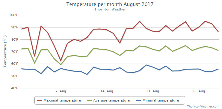
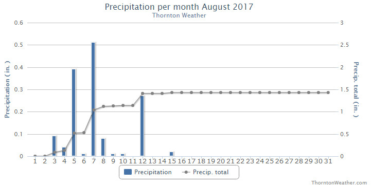
The last full summer month of the year has come to a close in a rather un-dramatic fashion. Thornton saw a largely pleasant month with temperatures a good bit cooler than we usually expect to see. Precipitation was right near normal however, all of it fell during the first half of the month.
High pressure ruled for the first two days of the month but then the ridge broke down bringing about cooler temperatures on the 3rd of the month. The cool down didn’t last long and while the heat returned for a couple of days, we did finally receive some moisture on the 4th and 5th.
Cooler than normal temperatures returned on the 6th and lasted through the next 10 days. The first half of the month also saw 10 days with measurable precipitation, our only precipitation for the month as the last half of the month saw none at all.
Dry and warm conditions were the rule of thumb for the last two weeks of the month. Both Thornton and Denver saw six of the last nine days of the month bring high temperatures at or above 90 degrees.
Our average temperature for the month came in at 68.9 degrees. This was a good bit below the long term Denver average for August of 72.5 degrees. Out at DIA where the Mile High City’s official measurements are taken, the month was warmer than us but still cooler than normal with an average of 71.5 degrees.
Temperatures in Thornton ranged from a high mark reading of 94.9 degrees on the 29th of the month down to a low of 51.2 degrees on the 11th. Denver saw a maximum reading of 95 degrees on the 19th of the month and a low of 51 degrees on the 4th.
In terms of precipitation, Denver averages 1.69 inches of precipitation during August. Thornton wasn’t too far short of that with 1.43 inches. However, all of that came during the first 15 days of the month. After that, we saw nothing. Denver best us, and the average, with 1.86 inches in their rain bucket.
Thornton, Colorado’s August 2017 Temperature Summary. (ThorntonWeather.com)
Thornton, Colorado’s August 2017 Precipitation Summary. (ThorntonWeather.com)
CLIMATE REPORT
NATIONAL WEATHER SERVICE DENVER/BOULDER CO
639 PM MDT FRI SEP 1 2017

...................................

...THE DENVER CO CLIMATE SUMMARY FOR THE MONTH OF AUGUST 2017...

CLIMATE NORMAL PERIOD 1981 TO 2010
CLIMATE RECORD PERIOD 1872 TO 2017

WEATHER         OBSERVED          NORMAL  DEPART  LAST YEAR`S
                 VALUE   DATE(S)  VALUE   FROM    VALUE  DATE(S)
                                          NORMAL
................................................................
TEMPERATURE (F)
RECORD
 HIGH             105   08/08/1878
 LOW               40   08/26/1910
                        08/25/1910
                        08/24/1910
HIGHEST            95   08/19        96      -1       97  08/09
LOWEST             51   08/04        50       1       47  08/25
                                                          08/20
AVG. MAXIMUM     85.7              87.2    -1.5     86.3
AVG. MINIMUM     57.3              57.9    -0.6     56.2
MEAN             71.5              72.5    -1.0     71.2
DAYS MAX >= 90     10              11.5    -1.5       15
DAYS MAX <= 32      0               0.0     0.0        0
DAYS MIN <= 32      0               0.0     0.0        0
DAYS MIN <= 0       0               0.0     0.0        0

PRECIPITATION (INCHES)
RECORD
 MAXIMUM         5.85   1979
 MINIMUM         0.02   1924
TOTALS           1.86              1.69    0.17     0.22
DAILY AVG.       0.06              0.05    0.01     0.01
DAYS >= .01         6               8.6    -2.6        4
DAYS >= .10         4               4.3    -0.3        1
DAYS >= .50         2               1.2     0.8        0
DAYS >= 1.00        0               0.3    -0.3        0
GREATEST
 24 HR. TOTAL    0.90   08/07 TO 08/07           08/24 TO 08/24

SNOWFALL (INCHES)
RECORDS TOTAL     0.0
TOTALS            0.0 2017          0.0


DEGREE_DAYS
HEATING TOTAL       8                10      -2       15
 SINCE 7/1          8                16      -8       15
COOLING TOTAL     216               244     -28      218
 SINCE 1/1        749               688      61      762

FREEZE DATES
RECORD
 EARLIEST     09/08/1962
 LATEST       06/08/2007
EARLIEST                        10/07
LATEST                          05/05
.........................................................

WIND (MPH)
AVERAGE WIND SPEED              9.2
RESULTANT WIND SPEED/DIRECTION   2/189
HIGHEST WIND SPEED/DIRECTION    49/320    DATE  08/04
HIGHEST GUST SPEED/DIRECTION    62/320    DATE  08/04

SKY COVER
POSSIBLE SUNSHINE (PERCENT)   MM
AVERAGE SKY COVER           0.50
NUMBER OF DAYS FAIR            7
NUMBER OF DAYS PC             21
NUMBER OF DAYS CLOUDY          3

AVERAGE RH (PERCENT)     50

WEATHER CONDITIONS. NUMBER OF DAYS WITH
THUNDERSTORM             13     MIXED PRECIP               0
HEAVY RAIN                3     RAIN                       4
LIGHT RAIN               12     FREEZING RAIN              0
LT FREEZING RAIN          0     HAIL                       0
HEAVY SNOW                0     SNOW                       0
LIGHT SNOW                0     SLEET                      0
FOG                      10     FOG W/VIS <= 1/4 MILE      2
HAZE                      2

-  INDICATES NEGATIVE NUMBERS.
R  INDICATES RECORD WAS SET OR TIED.
MM INDICATES DATA IS MISSING.
T  INDICATES TRACE AMOUNT.
Whew! Is this September or July? As expected the mercury kept on climbing today and did indeed get into record-setting territory.
At 1:53pm the temperature at Denver International Airport where the Mile High City’s official records are kept reached 97 degrees. This easily bests the previous record high for the date of 95 degrees set in 1995.
Additionally the reading tied the record for hottest September temperature. Six other times in the past the mercury reached 97 degrees during September occurring on September 1, 1995, September 4, 1960, September 4, 1995, September 5, 1899, September 5, 2013, and September 6, 2013.
Here in Thornton, we were actually warmer than DIA (a rarity). Temperatures here topped out at 98.5 degrees at 1:20pm.
While above normal temperatures (but not record-setting) are expected for tomorrow, we do expect to see a significant cool down Tuesday then see things bounce back to readings a bit above normal for the balance of the week. See the extended forecast here.
Following on what was a cool but dry August, some are certainly hoping for a bit of precipitation. The month can bring plenty of rain and even our first snow of the season but more often than not, it is one of the most pleasant along the Colorado Front Range.
As temperatures start to drop, September usually reminds us that summer is at an end and fall is now here. Sunshine is predominant though as the month actually has the highest percentage of sun out of any month. Sunny days and clear, cool nights are the standard weather pattern for the month.
The month can bring extremes however. We will of course forever remember 2013’s devastating floods brought on by record-setting rain. Longtime residents might remember September 1971 which brought over 17 inches of snowfall.
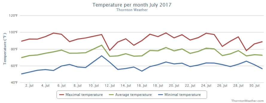
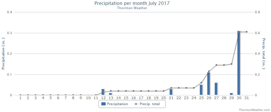
The month of July might have seemed quite hot but in fact mercury readings were right near normal. What likely caused the misconception is the fact that we saw far less than normal rain.
High pressure did dominate for much of the month and while monsoonal flow did bring rain to eastern Colorado, it largely missed our area. The Palmer Divide and southeastern Colorado were beneficiaries for much of the month but for us it wasn’t until the last week that we saw relief.
Thornton’s average temperature for the month came in at 74.1 degrees. This is almost exactly matches Denver’s long-term July average of 74.2 degrees. Out at DIA where the Mile High City’s official temperatures are taken, it shows a far warmer month with an average of 76.4 degrees.
Temperatures here ranged from a maximum of 99.2 degrees on the 19th down to a low of 50.1 degrees on the morning of the 1st. Out at the airport, their highest reading was actually 100 degrees seen on the 6th and again on the 19th. The low out there was 51 degrees on the 1st.
On average Denver receives 2.16 inches of precipitation during July. Both Thornton and Denver fell far short of that mark. We managed to record 0.61 inches in our bucket during the month, more than half of which fell on the second to last day of the month. At DIA, Denver recorded 0.47 inches.
Thornton, Colorado’s July 2017 temperature summary. (ThorntonWeather.com)Thornton, Colorado’s July 2017 precipitation summary. (ThorntonWeather.com)
From the National Weather Service:
CLIMATE REPORT
NATIONAL WEATHER SERVICE DENVER/BOULDER CO
656 AM MDT TUE AUG 1 2017

...................................

...THE DENVER CO CLIMATE SUMMARY FOR THE MONTH OF JULY 2017...

CLIMATE NORMAL PERIOD 1981 TO 2010
CLIMATE RECORD PERIOD 1872 TO 2017

WEATHER         OBSERVED          NORMAL  DEPART  LAST YEAR`S
                 VALUE   DATE(S)  VALUE   FROM    VALUE  DATE(S)
                                          NORMAL
................................................................
TEMPERATURE (F)
RECORD
 HIGH             105   07/20/2005
 LOW               42   07/04/1903
                        07/31/1873
HIGHEST           100   07/19        99      -5      102  07/10
                        07/06
LOWEST             51   07/01        51       9       51  07/12
AVG. MAXIMUM     91.5              89.4     2.1     92.0
AVG. MINIMUM     61.3              58.9     2.4     60.5
MEAN             76.4              74.2     2.2     76.2
DAYS MAX >= 90     20              16.0     4.0       22
DAYS MAX <= 32      0               0.0     0.0        0
DAYS MIN <= 32      0               0.0     0.0        0
DAYS MIN <= 0 0 0.0 0.0 0
PRECIPITATION (INCHES)
RECORD
 MAXIMUM 6.41 1965
 MINIMUM 0.01 1901
TOTALS 0.47 2.16 -1.69 1.07
DAILY AVG. 0.02 0.07 -0.05 0.03
DAYS >= .01         6               8.3    -2.3        6
DAYS >= .10         3               4.3    -1.3        4
DAYS >= .50         0               1.4    -1.4        1
DAYS >= 1.00        0               0.7    -0.7        0
GREATEST
 24 HR. TOTAL    0.15   07/21 TO 07/21           07/01 TO 07/01
                                                          06/30 TO 07/01
                                                          07/01 TO 07/01

SNOWFALL (INCHES)
RECORDS TOTAL      0.0
 TOTALS            0.0 2017         0.0

DEGREE_DAYS
HEATING TOTAL       0                 6      -6        0
 SINCE 7/1          0                 6      -6        0
COOLING TOTAL     360               289      71      356
 SINCE 1/1        533               444      89      544

FREEZE DATES
RECORD
 EARLIEST     09/08/1962
 LATEST       06/08/2007
EARLIEST                        10/07
LATEST                          05/05
..................................................

WIND (MPH)
AVERAGE WIND SPEED              9.6
RESULTANT WIND SPEED/DIRECTION   3/204
HIGHEST WIND SPEED/DIRECTION    45/120    DATE  07/15
HIGHEST GUST SPEED/DIRECTION    53/120    DATE  07/15

SKY COVER
POSSIBLE SUNSHINE (PERCENT)   MM
AVERAGE SKY COVER           0.50
NUMBER OF DAYS FAIR            6
NUMBER OF DAYS PC             21
NUMBER OF DAYS CLOUDY          4

AVERAGE RH (PERCENT)     45

WEATHER CONDITIONS. NUMBER OF DAYS WITH
THUNDERSTORM              9     MIXED PRECIP               0
HEAVY RAIN                0     RAIN                       3
LIGHT RAIN                9     FREEZING RAIN              0
LT FREEZING RAIN          0     HAIL                       0
HEAVY SNOW                0     SNOW                       0
LIGHT SNOW                0     SLEET                      0
FOG                       3     FOG W/VIS <= 1/4 MILE      1
HAZE                      3

-  INDICATES NEGATIVE NUMBERS.
R  INDICATES RECORD WAS SET OR TIED.
MM INDICATES DATA IS MISSING.
T  INDICATES TRACE AMOUNT.
As summer vacations wind down and families prepare to send their kids back to school in August, Colorado weather also starts to settle down. The chances for severe weather decrease markedly during August and by the end of the month daytime temperatures are dropping quite a bit as well.
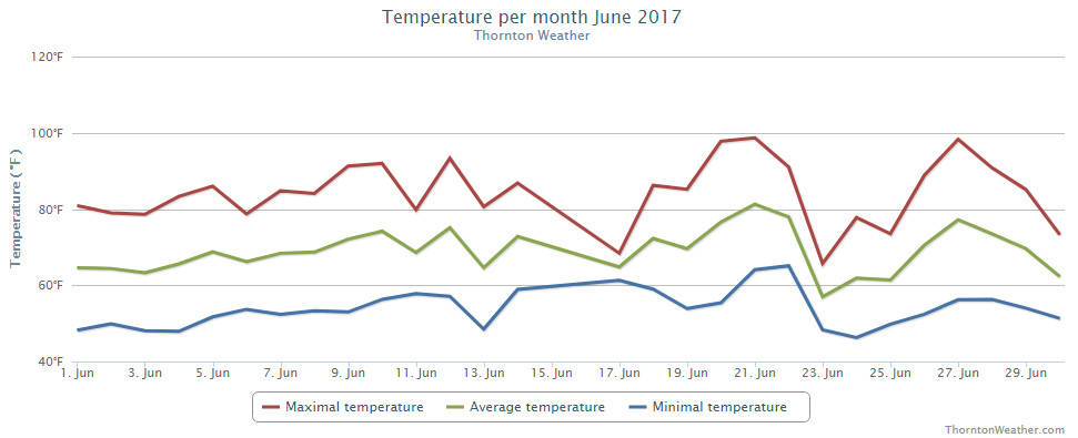
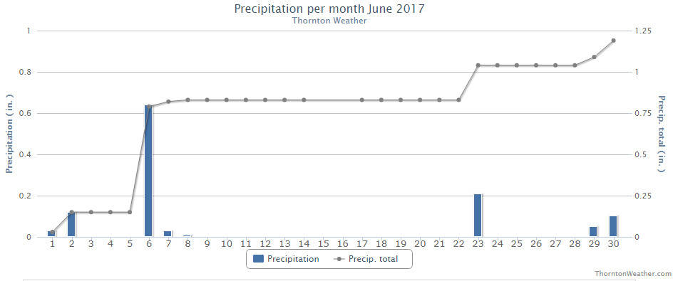
High pressure was the general rule for much of the month of June 2017. This resulted in overall average temperatures that were warmer than normal and precipitation that fell a good ways short of average.
The month was largely short on weather excitement, beyond the temps and lack of precipitation. The National Weather Service said that 23 of the 30 days saw above normal temperature readings. Denver recorded only five days with precipitation while in Thornton we saw eight.
Thornton saw an overall average monthly temperature of 69.2 degrees. Out at DIA where Denver’s official measurements are taken, the Mile High City was close with an average of 69.5 degrees. Both locations’ readings were well above the long term June average of 67.4 degrees.
Temperatures in Thornton ranged from a high of 98.7 degrees on the 21st down to a low of 46.3 degrees on the morning of the 24th. Denver saw a maximum of 99 degrees on the 20th and a low of 42 degrees on the 13th.
In terms of precipitation, Denver averages 1.98 inches during the month of June. Thornton fell short of the mark with 1.20 inches falling into our rain bucket while Denver’s reading was far worse with a mere 0.33 inches falling there.
Neither Thornton nor Denver saw any snowfall during the month.
Thornton, Colorado’s June 2017 temperature summary. (ThorntonWeather.com)Thornton, Colorado’s June 2017 precipitation summary. (ThorntonWeather.com)
From the National Weather Service:
CLIMATE REPORT
NATIONAL WEATHER SERVICE DENVER/BOULDER CO
729 AM MDT SAT JUL 1 2017

...................................

...THE DENVER CO CLIMATE SUMMARY FOR THE MONTH OF JUNE 2017...

CLIMATE NORMAL PERIOD 1981 TO 2010
CLIMATE RECORD PERIOD 1872 TO 2017

WEATHER         OBSERVED          NORMAL  DEPART  LAST YEAR`S
                 VALUE   DATE(S)  VALUE   FROM    VALUE  DATE(S)
                                          NORMAL
................................................................
TEMPERATURE (F)
RECORD
 HIGH             105   06/26/2012
                        06/25/2012
  LOW              30   06/02/1951

HIGHEST            99   06/20        96       3       98  06/21
LOWEST             42   06/13        42       0       49  06/02
AVG. MAXIMUM     85.5              82.4     3.1     85.5
AVG. MINIMUM     53.6              52.3     1.3     56.2
MEAN             69.5              67.4     2.1     70.8
DAYS MAX >= 90      9               7.9     1.1       12
DAYS MAX <= 32      0               0.0     0.0        0
DAYS MIN <= 32      0               0.0     0.0        0
DAYS MIN <= 0 0 0.0 0.0 0
PRECIPITATION (INCHES)
RECORD
 MAXIMUM 4.96 1882
 MINIMUM T 1890
TOTALS 0.33 1.98 -1.65 1.62
DAILY AVG. 0.01 0.07 -0.06 0.05
DAYS >= .01         5               8.4    -3.4        7
DAYS >= .10         2               4.6    -2.6        4
DAYS >= .50         0               1.4    -1.4        1
DAYS >= 1.00        0               0.3    -0.3        0
GREATEST
 24 HR. TOTAL    0.13   06/29 TO 06/29           06/13 TO 06/13

SNOWFALL (INCHES)
RECORD            0.5 1953
 TOTAL            0.0 2017          0.0

DEGREE_DAYS
HEATING TOTAL      25                62     -37        4
 SINCE 7/1       5109              6058    -949     5560
COOLING TOTAL     167               133      34      185
 SINCE 1/1        173               155      18      188

FREEZE DATES
RECORD
 EARLIEST     09/08/1962
 LATEST       06/08/2007
EARLIEST      04/01             10/07
LATEST        05/04             05/05
....................................................

WIND (MPH)
AVERAGE WIND SPEED              10.1
RESULTANT WIND SPEED/DIRECTION   2/135
HIGHEST WIND SPEED/DIRECTION    44/270    DATE  06/27
HIGHEST GUST SPEED/DIRECTION    66/270    DATE  06/27

SKY COVER
POSSIBLE SUNSHINE (PERCENT)   MM
AVERAGE SKY COVER           0.50
NUMBER OF DAYS FAIR            6
NUMBER OF DAYS PC             22
NUMBER OF DAYS CLOUDY          2

AVERAGE RH (PERCENT)     47

WEATHER CONDITIONS. NUMBER OF DAYS WITH
THUNDERSTORM             10     MIXED PRECIP               0
HEAVY RAIN                2     RAIN                       2
LIGHT RAIN                8     FREEZING RAIN              0
LT FREEZING RAIN          0     HAIL                       0
HEAVY SNOW                0     SNOW                       0
LIGHT SNOW                0     SLEET                      0
FOG                       3     FOG W/VIS <= 1/4 MILE      0
HAZE                      1

-  INDICATES NEGATIVE NUMBERS.
R  INDICATES RECORD WAS SET OR TIED.
MM INDICATES DATA IS MISSING.
T  INDICATES TRACE AMOUNT.
Change is of course the one constant in Denver’s weather but come July, things actually get pretty consistent.
The standard formula for a day in July is a sunny morning, clouds developing in the late morning and early afternoon. Come mid-afternoon, thunderstorms are rolling off of the foothills and into the metro area and the eastern plains. These storms do occasionally reach severe status containing hail, gusty winds and heavy downpours of rain.
We knew it would be hot today and the proof is in the numbers as Denver set a new record high temperature for the date.
According to the National Weather Service, the mercury topped out at 99 degrees at Denver International Airport. This breaks the previous record high for June 20 of 97 degrees set in 2007.
Here in Thornton, we almost matched the record with a high of 97.9 degrees at 3:57pm.
There will be no break from the heat until Friday.
Tomorrow’s forecast high of 98 degrees mirrors today’s high and will again come close to the record for June 21 (99 degrees in 2007). Thursday does cool some but with a forecast high of 91 degrees, the reading will still be well above normal for the date (85 degrees).
Stay up to date with Thornton’s weather: Be sure to ‘like’ us on Facebook, follow us on Twitter and add us to your Google+ circles.
Weather, natural disasters & climate news and information.
 With the first full month of fall here, October usually brings one of the quietest weather months in the Denver area with plenty of mild, sunny days and clear, cool nights.


 Following on what was a cool but dry August, some are certainly hoping for a bit of precipitation. The month can bring plenty of rain and even our first snow of the season but more often than not, it is one of the most pleasant along the Colorado Front Range.