As summer vacations wind down and families prepare to send their kids back to school in August, Colorado weather also starts to settle down. The chances for severe weather decrease markedly during August and by the end of the month daytime temperatures are dropping quite a bit as well.
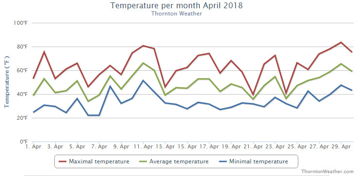
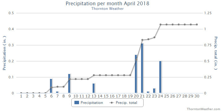
The month of April was one that failed to bring much in the way of snow or rain. This exacerbated the growing drought conditions, despite the end of the month bring some relief.
The first third of the month did bring a few days with light snow but nothing that ever amounted to much. Temperatures overall were a bit warmer than normal during the period and many days featured breezy winds serving to help dry things out.
We then put together three unseasonably warm days from the 10th to the 12th. The 13th saw things cool down but the majority of the snow in the region stayed well east of Thornton.
Perhaps the most notable event of the month came on the 17th when a strong upper level system passed over us. This brought extremely strong winds and resulted in Thornton recording its strongest wind gust in the past 10 plus years (62.1 mph).
Finally on the 20th we started seeing some precipitation with two of the next five days seeing light snow and the others having some rain. The month wrapped up with four straight days of temperatures well above normal.
Thornton’s overall average temperature for the month came in at 48.3 degrees. This was nearly a full degree warmer than the long term Denver average temperature for the month of 47.4 degrees. Out at Denver International Airport where the Mile High City’s official measurements are taken, it was slightly cooler with an average reading of 47.8 degres.
Temperatures in Thornton ranged from a high of 83.6 degrees on the 29th down to our coldest reading of 22.1 degrees on the morning of the 6th and the 7th. Denver’s maximum and minimum were similar with 83 degrees on the 29th and 21 degrees on the 6th.
In terms of precipitation, Denver averages 1.71 inches of liquid precip during April Thornton saw only 1.07 inches while Denver was even drier with 0.86 inches.
Snowfall at both locations fell short of the April average of 6.8 inches. Thornton recorded 3.9 inches while Denver only saw 1.5 inches.
Thornton, Colorado’s April 2018 temperature summary. (ThorntonWeather.com)Thornton, Colorado’s April 2018 precipitation summary. (ThorntonWeather.com)
CLIMATE REPORT
NATIONAL WEATHER SERVICE DENVER/BOULDER CO
1208 PM MDT WED MAY 2 2018

...................................

...THE DENVER CO CLIMATE SUMMARY FOR THE MONTH OF APRIL 2018...

CLIMATE NORMAL PERIOD 1981 TO 2010
CLIMATE RECORD PERIOD 1872 TO 2018

WEATHER         OBSERVED          NORMAL  DEPART  LAST YEAR`S
                 VALUE   DATE(S)  VALUE   FROM    VALUE  DATE(S)
                                          NORMAL
................................................................
TEMPERATURE (F)
RECORD
 HIGH              90   04/30/1992
 LOW               -2   04/02/1975
HIGHEST            83   04/29                         79  04/14
                                                          04/13
LOWEST             21   04/06                         24  04/10
AVG. MAXIMUM     63.2              61.5     1.7     63.2
AVG. MINIMUM     32.5              33.3    -0.8     34.5
MEAN             47.8              47.4     0.4     48.9
DAYS MAX >= 90      0               0.0     0.0        0
DAYS MAX <= 32      0               0.3    -0.3        1
DAYS MIN <= 32     16              13.0     3.0       15
DAYS MIN <= 0       0               0.0     0.0        0

PRECIPITATION (INCHES)
RECORD
 MAXIMUM         8.24   1900
 MINIMUM         0.03   1963
TOTALS           0.86              1.71   -0.85     0.98
DAILY AVG.       0.03              0.06   -0.03     0.03
DAYS >= .01         8               9.1    -1.1       10
DAYS >= .10         4               4.5    -0.5        5
DAYS >= .50         0               0.9    -0.9        0
DAYS >= 1.00        0               0.5    -0.5        0
GREATEST
 24 HR. TOTAL    0.34   04/21 TO 04/21           04/29 TO 04/29

         OBSERVED                  NORMAL  DEPART  LAST YEAR`S

SNOWFALL  (INCHES)
TOTALS             1.5              6.8

DEGREE_DAYS
HEATING TOTAL     509               529     -20     478
 SINCE 7/1       5250              5731    -481     4803
COOLING TOTAL       2                 1       1        0
SINCE 1/1           2                 1       1        0

FREEZE DATES
RECORD
 EARLIEST     09/08/1962
 LATEST       06/08/2007
EARLIEST                        10/07
LATEST                          05/05
.................................................................

WIND (MPH)
AVERAGE WIND SPEED              12.5
RESULTANT WIND SPEED/DIRECTION    M
HIGHEST WIND SPEED/DIRECTION    46/320    DATE  04/13
HIGHEST GUST SPEED/DIRECTION    70/280    DATE  04/17

SKY COVER
POSSIBLE SUNSHINE (PERCENT)   MM
AVERAGE SKY COVER           0.60
NUMBER OF DAYS FAIR            6
NUMBER OF DAYS PC             17
NUMBER OF DAYS CLOUDY          7

AVERAGE RH (PERCENT)     49

WEATHER CONDITIONS. NUMBER OF DAYS WITH
THUNDERSTORMS             3   MIXED PRECIP           0
HEAVY RAIN                0   RAIN                   2
LIGHT RAIN                9   FREEZING RAIN          0
LT FREEZING RAIN          0   HAIL                   0
HEAVY SNOW                0   SNOW                   2
LIGHT SNOW                8   FOG W/VIS <=1/4 MILE   1
FOG                       8   HAZE                   2

-  INDICATES NEGATIVE NUMBERS.
R  INDICATES RECORD WAS SET OR TIED.
MM INDICATES DATA IS MISSING.
T  INDICATES TRACE AMOUNT.
February in Colorado typically brings to an end an extended period when average temperatures are at their lowest. Winter begins to loosen its grip and temperatures get warmer but precipitation is not a particularly common event during the month.
Thus far our snow season has been relatively dismal with the seasonal total in Thornton more than 10 inches below average. In the high country, the snowpack is not faring much better. February is only our sixth snowiest month so we may not see much snowfall for the balance of the month.
Temperatures however do usually see a nice rebound during the month. Average high temperatures climb from an average of 44 degrees at the start to 50 degrees by the end of February.
With the last part of December fresh in our minds, it would not be surprising to think of the month as a cold one. However, reaching back, if you recall, we actually enjoyed a lot of mild days earlier and very little precipitation. As a result, December 2017 goes into the books as a warm and dry one.
The first half of the month was notable for stable conditions yielding above normal temperatures and no precipitation. Denver set a record high temperature on the 12th of 69 degrees which was also our warmest reading of the month.
Not long after the warmth came the cold. Arctic air infiltrated from the north on the 21st resulting in much cooler temperatures and a pre-Christmas snow. This was followed by another snow on the 23rd that lasted into the early morning hours of Christmas Eve. Single digit lows were seen for seven days from the 21st to the 27th.
We then saw a brief warmup for the 27th to the 29th but that was short lived. We closed out the month with the final two days’ high temperatures failing to reach even the freezing mark.
On average, Denver’s temperature for December comes in at 30.0 degrees. Both Thornton and the Mile High City came in above that with average readings of 31.8 degrees and 33.2 degrees respectively.
Thornton saw its warmest temperature reading of 69.1 degrees on the 12th and its coldest of 1.6 degrees on the morning of the 27th. Denver’s warmest reading of 69 degrees also came on the 12th and its coldest of -4 degrees came on the 24th.
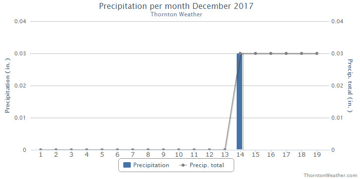
In terms of precipitation, Thornton saw a mere 0.16 inch of liquid in its bucket for the month. Denver was a bit better with 0.21 inches. Both were below the long-term Denver average of 0.35 inches.
December on average brings 8.5 inches of snowfall to Denver. Thornton fell well short of that with 4.7 inches and Denver just a bit less with 4.0 inches.
Thornton, Colorado’s December 2017 temperature summary. (ThorntonWeather.com)Thornton, Colorado’s December 2017 precipitation summary. (ThorntonWeather.com)
CLIMATE REPORT
NATIONAL WEATHER SERVICE DENVER/BOULDER CO
645 AM MST MON JAN 1 2018

...................................

...THE DENVER CO CLIMATE SUMMARY FOR THE MONTH OF DECEMBER 2017...

CLIMATE NORMAL PERIOD 1981 TO 2010
CLIMATE RECORD PERIOD 1872 TO 2017

WEATHER         OBSERVED          NORMAL  DEPART  LAST YEAR`S
                 VALUE   DATE(S)  VALUE   FROM    VALUE  DATE(S)
                                          NORMAL
................................................................
TEMPERATURE (F)
RECORD
 HIGH              79   12/05/1939
 LOW              -25   12/22/1990
                        12/24/1876
HIGHEST            69   12/12        62       7       65  12/30
LOWEST             -4   12/24        -4       0      -15  12/17
AVG. MAXIMUM     48.3              42.8     5.5     42.7
AVG. MINIMUM     18.0              17.1     0.9     12.9
MEAN             33.2              30.0     3.2     27.8
DAYS MAX >= 90      0               0.0     0.0        0
DAYS MAX <= 32      4               5.8    -1.8        6
DAYS MIN <= 32     28              29.4    -1.4       30
DAYS MIN <= 0       1               2.0    -1.0        4

PRECIPITATION (INCHES)
RECORD
 MAXIMUM         5.21   1913
 MINIMUM         0.00   1881
TOTALS           0.21              0.35   -0.14     0.78
DAILY AVG.       0.01              0.01    0.00     0.03
DAYS >= .01         4               4.1    -0.1        6
DAYS >= .10         1               1.1    -0.1        2
DAYS >= .50         0               0.1    -0.1        0
DAYS >= 1.00        0               0.0     0.0        0
GREATEST
 24 HR. TOTAL    0.10   12/23 TO 12/23
 STORM TOTAL     0.10   12/23 TO 12/23

SNOWFALL (INCHES)
RECORDS
 TOTAL           57.4   1913
TOTALS            4.0   2017        8.5

DEGREE_DAYS
HEATING TOTAL     979              1086    -107     1146
 SINCE 7/1       2150              2468    -318     2042
COOLING TOTAL       0                 0       0        0
 SINCE 1/1        881               769     112      878

FREEZE DATES
RECORD
 EARLIEST     09/08/1962
 LATEST       06/08/2007
EARLIEST                        10/07
LATEST                          05/05
.................................................................

WIND (MPH)
AVERAGE WIND SPEED              10.0
RESULTANT WIND SPEED/DIRECTION   2/214
HIGHEST WIND SPEED/DIRECTION    37/270    DATE  12/04
HIGHEST GUST SPEED/DIRECTION    48/280    DATE  12/04

SKY COVER
POSSIBLE SUNSHINE (PERCENT)   MM
AVERAGE SKY COVER           0.50
NUMBER OF DAYS FAIR            8
NUMBER OF DAYS PC             18
NUMBER OF DAYS CLOUDY          5

AVERAGE RH (PERCENT)          49

WEATHER CONDITIONS. NUMBER OF DAYS WITH
FOG OR MIST                   12
FOG VSBY LESS 1/4 MI           4
THUNDER                        0
ICE PELLETS                    0
HAIL                           0
FREEZING RAIN DRIZZLE          0
DUST STORM                     0
SMOKE OR HAZE                  5
BLOWING SNOW                   0
TORNADO                        0

-  INDICATES NEGATIVE NUMBERS.
R  INDICATES RECORD WAS SET OR TIED.
MM INDICATES DATA IS MISSING.
T  INDICATES TRACE AMOUNT.
As we begin the new year the winter chill begins to set in. While January can see its share of extremes, the month historically sees stable temperatures and is usually relatively dry.
January ranks as the second coldest month in Denver next to December with average temperatures remaining virtually the same from the start to the end of the month.
In terms of snowfall, the month only ranks as the fourth snowiest and it is not uncommon for it to be quite dry.
What does January 2018 hold for us? Follow the link to find out.
Winter officially begins at 9:28am MST on Thursday, December 21, 2017. (NOAA)
Astronomical winter arrives in Thornton Thursday morning and with the solstice also comes the shortest day of the year. Mother Nature as well appears set to bring in winter with a bit of a bang and a change in our recent mild, dry weather pattern.
Winter officially begins at 9:28am MST on Thursday, December 21.
The Winter Solstice occurs when the North Pole is tilted at its furthest from the sun – 23.5 degrees away. This results in the shortest day of the year in the Northern Hemisphere.
Here in Denver, with sunrise at 7:17am and sunset at 4:38pm, our day Thursday will be 9 hours, 21 minutes and 16 seconds long. The following day, Friday, it will be three seconds longer and each day from now through to the Summer Solstice in June will get gradually longer as well.
While we have a short day today, it is nothing like what will be experienced in the Arctic Circle. Areas north of there to the North Pole will have no direct sunlight at all. Conversely, areas south of the Antarctic Circle toward the South Pole will have 24 hours of daylight and have a midnight sun.
Did you know that there is a difference between the astronomical seasons that we are discussing here and meteorological seasons?
Meteorological seasons differ slightly and are geared toward matching the calendar with the annual temperature cycle. This is done primarily for meteorological observing and forecasting and in many ways it is more logical than the astronomical seasons.
For the Northern Hemisphere, the meteorological spring covers the months of March, April and May. Summer brings the hottest months of the year and so meteorological summer is June, July and August. Meteorological fall then is September, October and November followed by the coldest months of December, January and February as meteorological winter.
November proved to be an extraordinarily warm and dry month. Does December have hope for relief?
The month of December brings with it the official start of winter and oftentimes, colder and snowier weather conditions.
It however can also offer unseasonably warm temperatures and bone dry conditions. Given our recent mild and dry weather, we are certainly hoping for a change in the coming month.
Overall December’s monthly mean temperature of 30.0 degrees (1981 – 2010 averages) makes it our coldest month. Snow is always on everyone’s mind this time of year but December is only our 3rd snowiest month behind March and November with an average of 8.5 inches of the white stuff.
Illustration of flowing water under the Antarctic ice sheet. Blue dots indicate lakes, lines show rivers. Marie Byrd Land is part of the bulging “elbow” leading to the Antarctic Peninsula, left center. Continue reading Hot News from the Antarctic Underground→
The weather during the month of November in Denver metro area can offer just about anything. While it is normally a quiet month, it can be prone to extremes.
November has historically been one of Denver’s snowiest months and major snowstorms are not entirely uncommon. However conditions can also be quite dry.
Temperatures during the month continue to cool as we get closer to winter and by the end of the month the low temperatures routinely dip to 20 degrees or below. At times it can in fact bring conditions more like what we see in January.
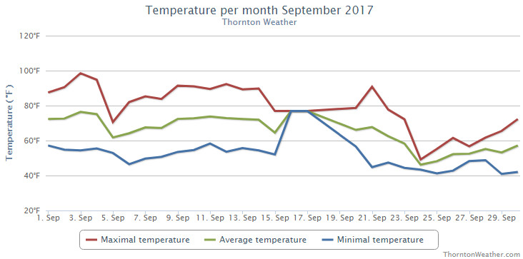
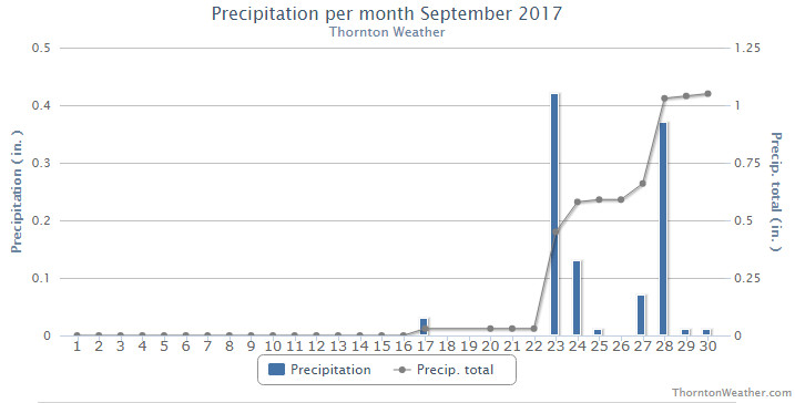
The month of September 2017 saw significant differences between the start and the end. The first two-thirds of the month were extraordinarily dry with temperatures well above normal. The last 10 days brought a big change though with damp conditions and much cooler conditions.
High pressure dominated the region for the first few weeks of the month. During this period when we normally see cooler temperatures, we instead saw highs oftentimes at or above 90 degrees and a couple of record high readings. Additionally, it was exceedingly dry with Thornton only received 0.03 inches of precipitation through the first 22 days of the month.
Big changes arrived and the last nine days of the month stood it stark contrast to the rest of September. Low pressure and a series of disturbances brought much cooler temperatures and much-needed precipitation, including snowfall in the high country. Seven out of the last eight days saw below normal high temperature readings and enough precipitation fell to push us to just above normal.
Thornton’s overall average temperature for the month came in at 62.4 degrees. This was a full degree cooler than Denver’s long term September average of 63.4 degrees. Out at DIA where Denver’s official measurements are taken, it was a good bit warmer with an average temperature of 65.1 degrees.
Temperatures in Thornton ranged from a high of 98.5 degrees on the third and a low of 40.9 degrees on the morning of the 29th. Denver saw their high of 97 degrees on the third as well and their coldest reading of 40 degrees on the 20th.
Two record high temperatures were officially set or tied for the Mile High City. The high temperature of 97 degrees on the third tied the record high for the date. A reading of 92 degrees on the 21st set a new record high for that date.
In terms of precipitation, Denver averages 0.96 inches during September. Thornton tallied 1.05 inches in the rain bucket while Denver bested us with 1.26 inches.
Thornton, Colorado’s September 2017 Temperature Summary. (ThorntonWeather.com)Thornton, Colorado’s September 2017 Precipitation Summary. (ThorntonWeather.com)
From the National Weather Service:
CLIMATE REPORT
NATIONAL WEATHER SERVICE DENVER/BOULDER CO
244 AM MDT SUN OCT 1 2017

...................................

...THE DENVER CO CLIMATE SUMMARY FOR THE MONTH OF SEPTEMBER 2017...

CLIMATE NORMAL PERIOD 1981 TO 2010
CLIMATE RECORD PERIOD 1872 TO 2017

WEATHER         OBSERVED          NORMAL  DEPART  LAST YEAR`S
                 VALUE   DATE(S)  VALUE   FROM    VALUE  DATE(S)
                                          NORMAL
................................................................
TEMPERATURE (F)
RECORD
 HIGH              97   09/03/2017
                        09/06/2013
                        09/05/2013
 LOW               17   09/29/1985
HIGHEST            97R  09/03        91       6       93  09/05
LOWEST             40   09/20        35       5       37  09/10
AVG. MAXIMUM     79.0              78.5     0.5     82.3
AVG. MINIMUM     51.3              48.3     3.0     49.7
MEAN             65.1              63.4     1.7     66.0
DAYS MAX >= 90      9               3.4     5.6        6
DAYS MAX <= 32      0               0.0     0.0        0
DAYS MIN <= 32      0               0.8    -0.8        0
DAYS MIN <= 0 0 0.0 0.0 0 PRECIPITATION (INCHES) RECORD MAXIMUM 5.61 2013 MINIMUM T 1892 1944 TOTALS 1.26 0.96 0.30 0.28 DAILY AVG. 0.04 0.03 0.01 0.01 DAYS >= .01         6               6.5    -0.5        4
DAYS >= .10         2               3.3    -1.3        1
DAYS >= .50         1               0.6     0.4        0
DAYS >= 1.00        0               0.1    -0.1        0
GREATEST
 24 HR. TOTAL    0.83   09/23 TO 09/23           09/12 TO 09/12

SNOWFALL (INCHES)
RECORDS
 TOTAL             0.0
TOTALS            0.0               1.3

DEGREE_DAYS
HEATING TOTAL     122               125      -3       64
 SINCE 7/1        130               141     -11       79
COOLING TOTAL     131                76      55       99
 SINCE 1/1        880               764     116      861

FREEZE DATES
RECORD
 EARLIEST     09/08/1962
 LATEST       06/08/2007
EARLIEST                        10/07
LATEST                          05/05
...................................................

WIND (MPH)
AVERAGE WIND SPEED              9.6
RESULTANT WIND SPEED/DIRECTION   2/165
HIGHEST WIND SPEED/DIRECTION    40/020    DATE  09/19
HIGHEST GUST SPEED/DIRECTION    48/030    DATE  09/19

SKY COVER
POSSIBLE SUNSHINE (PERCENT)   MM
AVERAGE SKY COVER           0.50
NUMBER OF DAYS FAIR            9
NUMBER OF DAYS PC             15
NUMBER OF DAYS CLOUDY          6

AVERAGE RH (PERCENT)     48

WEATHER CONDITIONS. NUMBER OF DAYS WITH
THUNDERSTORM              0     MIXED PRECIP               0
HEAVY RAIN                1     RAIN                       1
LIGHT RAIN               10     FREEZING RAIN              0
LT FREEZING RAIN          0     HAIL                       0
HEAVY SNOW                0     SNOW                       0
LIGHT SNOW                0     SLEET                      0
FOG                       8     FOG W/VIS <= 1/4 MILE      1
HAZE                     10

-  INDICATES NEGATIVE NUMBERS.
R  INDICATES RECORD WAS SET OR TIED.
MM INDICATES DATA IS MISSING.
T  INDICATES TRACE AMOUNT.
Weather, natural disasters & climate news and information.

 February in Colorado typically brings to an end an extended period when average temperatures are at their lowest. Winter begins to loosen its grip and temperatures get warmer but precipitation is not a particularly common event during the month.
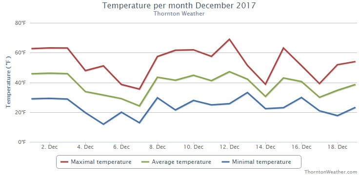
 As we begin the new year the winter chill begins to set in. While January can see its share of extremes, the month historically sees stable temperatures and is usually relatively dry.
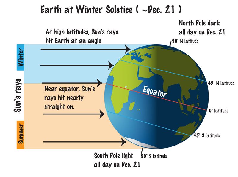
 November proved to be an extraordinarily warm and dry month. Does December have hope for relief?
 The weather during the month of November in Denver metro area can offer just about anything. While it is normally a quiet month, it can be prone to extremes.