High pressure was the general rule for much of the month of June 2017. This resulted in overall average temperatures that were warmer than normal and precipitation that fell a good ways short of average.
The month was largely short on weather excitement, beyond the temps and lack of precipitation. The National Weather Service said that 23 of the 30 days saw above normal temperature readings. Denver recorded only five days with precipitation while in Thornton we saw eight.
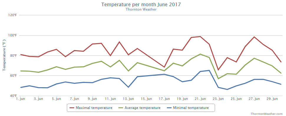
Thornton saw an overall average monthly temperature of 69.2 degrees. Out at DIA where Denver’s official measurements are taken, the Mile High City was close with an average of 69.5 degrees. Both locations’ readings were well above the long term June average of 67.4 degrees.
Temperatures in Thornton ranged from a high of 98.7 degrees on the 21st down to a low of 46.3 degrees on the morning of the 24th. Denver saw a maximum of 99 degrees on the 20th and a low of 42 degrees on the 13th.
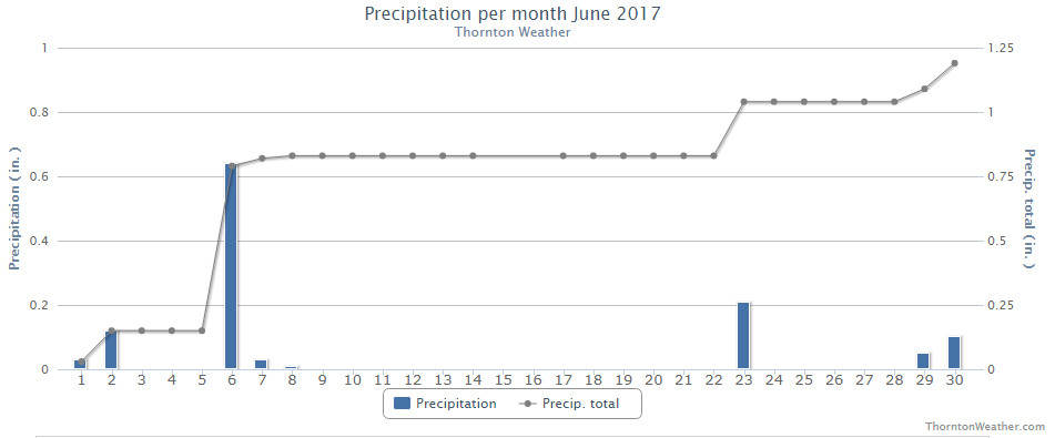
In terms of precipitation, Denver averages 1.98 inches during the month of June. Thornton fell short of the mark with 1.20 inches falling into our rain bucket while Denver’s reading was far worse with a mere 0.33 inches falling there.
Neither Thornton nor Denver saw any snowfall during the month.
Click here to view Thornton’s June 2017 climate report.
From the National Weather Service:
CLIMATE REPORT
NATIONAL WEATHER SERVICE DENVER/BOULDER CO
729 AM MDT SAT JUL 1 2017

...................................

...THE DENVER CO CLIMATE SUMMARY FOR THE MONTH OF JUNE 2017...

CLIMATE NORMAL PERIOD 1981 TO 2010
CLIMATE RECORD PERIOD 1872 TO 2017

WEATHER         OBSERVED          NORMAL  DEPART  LAST YEAR`S
                 VALUE   DATE(S)  VALUE   FROM    VALUE  DATE(S)
                                          NORMAL
................................................................
TEMPERATURE (F)
RECORD
 HIGH             105   06/26/2012
                        06/25/2012
  LOW              30   06/02/1951

HIGHEST            99   06/20        96       3       98  06/21
LOWEST             42   06/13        42       0       49  06/02
AVG. MAXIMUM     85.5              82.4     3.1     85.5
AVG. MINIMUM     53.6              52.3     1.3     56.2
MEAN             69.5              67.4     2.1     70.8
DAYS MAX >= 90      9               7.9     1.1       12
DAYS MAX <= 32      0               0.0     0.0        0
DAYS MIN <= 32      0               0.0     0.0        0
DAYS MIN <= 0 0 0.0 0.0 0
PRECIPITATION (INCHES)
RECORD
 MAXIMUM 4.96 1882
 MINIMUM T 1890
TOTALS 0.33 1.98 -1.65 1.62
DAILY AVG. 0.01 0.07 -0.06 0.05
DAYS >= .01         5               8.4    -3.4        7
DAYS >= .10         2               4.6    -2.6        4
DAYS >= .50         0               1.4    -1.4        1
DAYS >= 1.00        0               0.3    -0.3        0
GREATEST
 24 HR. TOTAL    0.13   06/29 TO 06/29           06/13 TO 06/13

SNOWFALL (INCHES)
RECORD            0.5 1953
 TOTAL            0.0 2017          0.0

DEGREE_DAYS
HEATING TOTAL      25                62     -37        4
 SINCE 7/1       5109              6058    -949     5560
COOLING TOTAL     167               133      34      185
 SINCE 1/1        173               155      18      188

FREEZE DATES
RECORD
 EARLIEST     09/08/1962
 LATEST       06/08/2007
EARLIEST      04/01             10/07
LATEST        05/04             05/05
....................................................

WIND (MPH)
AVERAGE WIND SPEED              10.1
RESULTANT WIND SPEED/DIRECTION   2/135
HIGHEST WIND SPEED/DIRECTION    44/270    DATE  06/27
HIGHEST GUST SPEED/DIRECTION    66/270    DATE  06/27

SKY COVER
POSSIBLE SUNSHINE (PERCENT)   MM
AVERAGE SKY COVER           0.50
NUMBER OF DAYS FAIR            6
NUMBER OF DAYS PC             22
NUMBER OF DAYS CLOUDY          2

AVERAGE RH (PERCENT)     47

WEATHER CONDITIONS. NUMBER OF DAYS WITH
THUNDERSTORM             10     MIXED PRECIP               0
HEAVY RAIN                2     RAIN                       2
LIGHT RAIN                8     FREEZING RAIN              0
LT FREEZING RAIN          0     HAIL                       0
HEAVY SNOW                0     SNOW                       0
LIGHT SNOW                0     SLEET                      0
FOG                       3     FOG W/VIS <= 1/4 MILE      0
HAZE                      1

-  INDICATES NEGATIVE NUMBERS.
R  INDICATES RECORD WAS SET OR TIED.
MM INDICATES DATA IS MISSING.
T  INDICATES TRACE AMOUNT.