Category Archives: Astronomy

NASA’s Cassini beams back stunning image of Saturn and Earth

The ringed planet of Saturn have been a source of fascination for earthlings for hundreds of years.  NASA’s Cassini probe, launched in 1997, has provided amazing views of the planet but none more so than the image released yesterday.

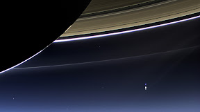
With the sun being blocked by Saturn, Cassini was able to capture the view of the planet and the inner solar system.  Actually a compilation of 141 images, the panoramic image shows a backlit Saturn as well as Mars, Venus and a pale blue Earth and our moon.

See the image below, click it for a larger view.  More on the image and Cassini’s mission below the photo.

On July 19, 2013, in an event celebrated the world over, NASA's Cassini spacecraft slipped into Saturn's shadow and turned to image the planet, seven of its moons, its inner rings -- and, in the background, our home planet, Earth.  Click the image for a larger view.  (NASA/JPL-Caltech/SSI)
On July 19, 2013, in an event celebrated the world over, NASA’s Cassini spacecraft slipped into Saturn’s shadow and turned to image the planet, seven of its moons, its inner rings — and, in the background, our home planet, Earth. Click the image for a larger view. (NASA/JPL-Caltech/SSI)

From NASA:

NASA has released a natural-color image of Saturn from space, the first in which Saturn, its moons and rings, and Earth, Venus and Mars, all are visible.

The new panoramic mosaic of the majestic Saturn system taken by NASA’s Cassini spacecraft, which shows the view as it would be seen by human eyes, was unveiled at the Newseum in Washington on Tuesday.

Cassini’s imaging team processed 141 wide-angle images to create the panorama. The image sweeps 404,880 miles (651,591 kilometers) across Saturn and its inner ring system, including all of Saturn’s rings out to the E ring, which is Saturn’s second outermost ring. For perspective, the distance between Earth and our moon would fit comfortably inside the span of the E ring.

“In this one magnificent view, Cassini has delivered to us a universe of marvels,” said Carolyn Porco, Cassini’s imaging team lead at the Space Science Institute in Boulder, Colo. “And it did so on a day people all over the world, in unison, smiled in celebration at the sheer joy of being alive on a pale blue dot.”

The mosaic is part of Cassini’s “Wave at Saturn” campaign, where on July 19, people for the first time had advance notice a spacecraft was taking their picture from planetary distances. NASA invited the public to celebrate by finding Saturn in their part of the sky, waving at the ringed planet and sharing pictures over the Internet.

An annotated version of the Saturn system mosaic labels points of interest. Earth is a bright blue dot to the lower right of Saturn. Venus is a bright dot to Saturn’s upper left. Mars also appears, as a faint red dot, above and to the left of Venus. Seven Saturnian moons are visible, including Enceladus on the left side of the image. Zooming into the image reveals the moon and the icy plume emanating from its south pole, supplying fine, powder-sized icy particles that make up the E ring.

The E ring shines like a halo around Saturn and the inner rings. Because it is so tenuous, it is best seen with light shining from behind it, when the tiny particles are outlined with light because of the phenomenon of diffraction. Scientists who focus on Saturn’s rings look for patterns in optical bonanzas like these. They use computers to increase dramatically the contrast of the images and change the color balance, for example, to see evidence for material tracing out the full orbits of the tiny moons Anthe and Methone for the first time.

“This mosaic provides a remarkable amount of high-quality data on Saturn’s diffuse rings, revealing all sorts of intriguing structures we are currently trying to understand,” said Matt Hedman, a Cassini participating scientist at the University of Idaho in Moscow. “The E ring in particular shows patterns that likely reflect disturbances from such diverse sources as sunlight and Enceladus’ gravity.”

Cassini does not attempt many images of Earth because the sun is so close to our planet that an unobstructed view would damage the spacecraft’s sensitive detectors. Cassini team members looked for an opportunity when the sun would slip behind Saturn from Cassini’s point of view. A good opportunity came on July 19, when Cassini was able to capture a picture of Earth and its moon, and this multi-image, backlit panorama of the Saturn system.

“With a long, intricate dance around the Saturn system, Cassini aims to study the Saturn system from as many angles as possible,” said Linda Spilker, Cassini project scientist based at NASA’s Jet Propulsion Laboratory in Pasadena, Calif. “Beyond showing us the beauty of the Ringed Planet, data like these also improve our understanding of the history of the faint rings around Saturn and the way disks around planets form — clues to how our own solar system formed around the sun.”

Launched in 1997, Cassini has explored the Saturn system for more than nine years. NASA plans to continue the mission through 2017, with the anticipation of many more images of Saturn, its rings and moons, as well as other scientific data.

The Cassini-Huygens mission is a cooperative project of NASA, the European Space Agency and the Italian Space Agency. JPL, a division of the California Institute of Technology, Pasadena, manages the mission for NASA’s Science Mission Directorate in Washington. JPL designed, developed and assembled the Cassini orbiter and its two onboard cameras. The imaging team is based at the Space Science Institute, Boulder, Colo.

Time to ‘fall back’ as Daylight Saving Time comes to an end

The United States returns to Standard Time at 2:00am Sunday as Daylight Saving Time comes to an end.

The biannual ritual of changing our clocks to adjust for Daylight Saving Time occurs tonight providing yet another signal of the changing of seasons.  The United States will ‘fall back’ one hour at 2:00am Sunday morning as we return to Standard Time.

The ritual of changing our clocks twice a year can be met with some resistance as some people struggle to adjust their body’s internal clock.  Others actually like the return to standard time as they get to enjoy an extra hour of sleep.

The time change definitely has big effects on the dawning of daylight and how early it gets dark in the evening.

Sunrise on Saturday occurs at 7:30am but on Sunday it will be at 6:29am. Similarly, sunset will occur at 5:55pm on Saturday but on Sunday the sun will disappear over the horizon at 4:54pm.

For many this means that when they get home from work it will now be dark and outdoor activities will be significantly curtailed as a result.

Arizona and Hawaii are the only states that do not observe Daylight Saving Time and remain on Standard Time year round.    The U.S. territories of Puerto Rico, American Samoa, Guam, Northern Mariana Islands, and the United States Virgin Islands also do not observe the event.

It won’t be all that long though before Daylight Saving Time returns.  On March 9, 2014 we will ‘spring forward.’

Daylight Saving Time Schedule

The mandated beginning and end of Daylight Saving Time has changed in the United States over the years.

The most recent schedule was set by the Energy Policy Act of 2005 and took effect in 2007.  We now ‘spring forward’ to begin Daylight Saving Time on the second Sunday in March and ‘fall back’ with the return to Standard Time on the first Sunday in November.

Year DST Begins 2 a.m.
(Second Sunday in March)
DST Ends 2 a.m.
(First Sunday in November)
2013 10 March 2013 3 November 2013
2014 9 March 2014 2 November 2014
2015 8 March 2015 1 November 2015
2016 13 March 2016 6 November 2016
2017 12 March 2017 5 November 2017
2018 11 March 2018 4 November 2018
2019 10 March 2019 3 November 2019

Hunter’s Moon brightens the early morning sky

Sunday morning the virtually full moon brightened the landscape.  Captured just before dawn, the image below is technically two days late to be one of the truly full Hunter’s moon but it still appears fully lit.

The Hunter’s Moon is the traditional term for the second full moon of autumn, following the Harvest Moon, the first of the season.  Typically this makes it the full moon we see in October but it can sometimes fall in November.

The name is popularly attributed to Native Americans and said to be named such because it meant it was time to go hunting and prepare for the arrival of winter.

More than folklore, there is something unique about the Hunter’s Moon.  See below the image for more details.

A very bright moon lights up the landscape two days after the full Hunter’s Moon.  Click the image for a larger view.
A very bright moon lights up the landscape two days after the full Hunter’s Moon. Click the image for a larger view. (ThorntonWeather.com)

From EarthSky.org:

But the Hunter’s Moon is also more than just a name. Nature is particularly cooperative around the time of the autumn equinox to make the full moonrises unique around this time.

Here’s what happens. On average, the moon rises about 50 minutes later each day. But when a full moon happens close to the autumnal equinox – either a Harvest or a Hunter’s Moon – the moon (at mid-temperate latitudes) rises only about 30 to 35 minutes later daily for several days before and after the full moon.

Why? The reason is that the ecliptic – or the moon’s orbital path – makes a narrow angle with the evening horizon around the time of the autumn equinox. The narrow angle of the ecliptic results in a shorter-than-usual rising time between successive moonrises around the full Hunter’s Moon.

These early evening moonrises are what make every Hunter’s Moon special. Every full moon rises around sunset. After the full Hunter’s Moon, you’ll see the moon ascending in the east relatively soon after sunset for a few days in a row at northerly latitudes.

NASA’s Cassini sends back images of Earth from 900 million miles away

In this rare image taken on July 19, 2013, the wide-angle camera on NASA's Cassini spacecraft has captured Saturn's rings and our planet Earth and its moon in the same frame. (NASA/JPL-Caltech/Space Science Institute)
In this rare image taken on July 19, 2013, the wide-angle camera on NASA’s Cassini spacecraft has captured Saturn’s rings and our planet Earth and its moon in the same frame. Scroll down for a larger image or click to view the full size image. (NASA/JPL-Caltech/Space Science Institute)

Launched in 1997, NASA’s Cassini space probe arrived in Saturn orbit in 2004 and has provided valuable insight into the sixth planet in our solar system as well as others.  On July 19 of this year the spacecraft took an extraordinary image of our home planet and moon as seen from nearly 900 miles away.

The image captured the planet around which Cassini is orbiting, its infamous rings and off in the distance, the planet Earth and our moon.  The pale blue hue of our planet is almost unmistakable among the features in the photo.  It truly does make one feel small when compared to the immensity of the heavens above.

NASA’s press release says in part:

“In the Cassini images Earth and the moon appear as mere dots — Earth a pale blue and the moon a stark white, visible between Saturn’s rings. It was the first time Cassini’s highest-resolution camera captured Earth and its moon as two distinct objects.

“It also marked the first time people on Earth had advance notice their planet’s portrait was being taken from interplanetary distances. NASA invited the public to celebrate by finding Saturn in their part of the sky, waving at the ringed planet and sharing pictures over the Internet. More than 20,000 people around the world participated.

“”We can’t see individual continents or people in this portrait of Earth, but this pale blue dot is a succinct summary of who we were on July 19,” said Linda Spilker, Cassini project scientist, at NASA’s Jet Propulsion Laboratory in Pasadena, Calif. “Cassini’s picture reminds us how tiny our home planet is in the vastness of space, and also testifies to the ingenuity of the citizens of this tiny planet to send a robotic spacecraft so far away from home to study Saturn and take a look-back photo of Earth.”

“Pictures of Earth from the outer solar system are rare because from that distance, Earth appears very close to our sun. A camera’s sensitive detectors can be damaged by looking directly at the sun, just as a human being can damage his or her retina by doing the same. Cassini was able to take this image because the sun had temporarily moved behind Saturn from the spacecraft’s point of view and most of the light was blocked.”

In this rare image taken on July 19, 2013, the wide-angle camera on NASA's Cassini spacecraft has captured Saturn's rings and our planet Earth and its moon in the same frame. Click to view the full size image.  (NASA/JPL-Caltech/Space Science Institute)
In this rare image taken on July 19, 2013, the wide-angle camera on NASA’s Cassini spacecraft has captured Saturn’s rings and our planet Earth and its moon in the same frame. Click to view the full size image. (NASA/JPL-Caltech/Space Science Institute)

Image captures the start of spring as seen from space

Spring officially began this morning at 5:02am MDT.  It is during this time, the vernal equinox, that the Earth’s axis is not tilted toward or away from the Sun.  As a result equal amounts of the Sun’s light are directed to the Northern and Southern Hemispheres.

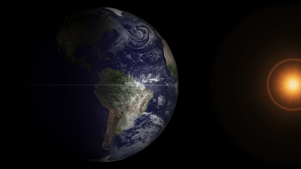
Soon after the event this morning one of NOAA’s GOES satellites captured the light on the face of the planet in near perfect equilibrium.

1309v1_20130320-Equinox.png
At 7:02 ET on March 20, 2013, Earth was at its equinox. At 7:45 ET, the GOES-13 satellite captured this full disk image of Earth. (NOAA) Click the image for a larger view.

From NOAA:

Mar 20, 2013
GOES Satellite Captures Spring Equinox
It is that time of year again (it happens twice) when the relative angle of Earth is perpendicular to the Sun, causing equal incoming solar energy to the Northern and Southern hemispheres – as well as equal day and nighttime. At 7:02 ET on March 20, 2013, Earth was at its equinox. At 7:45 ET, the GOES-13 satellite captured this full disk image of Earth. The visible imagery sensor on GOES requires sunlight to “see” clouds, and so it provides a useful example of the equinox. In this image the GOES imagery extends to each of the poles since the entire hemisphere is equally lit. After the equinox passes today, the Northern Hemisphere will be more lit than the Southern Hemisphere – causing the seasons. (Note: the Sun in this image is artificially created, though the GOES spacecraft does have sensors continually monitoring the Sun for solar activity.)

Meteor explodes over Russia with more energy than an atomic bomb, hundreds injured

2013-02-15_153151.jpg
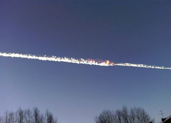
Flames from the explosion of the meteor were captured by Russians. (YouTube)

The Friday morning calm in Chelyabinsk, Russia was shattered by a meteor slamming into Earth’s atmosphere and exploding over the city in the Ural Mountains.  The energy released was greater than that of the first atomic bombs and caused widespread destruction and injuries.

  • Photo slideshow and video below

NASA says the 50 foot, 7,000 ton meteor entered the atmosphere at a speed of 40,000 mph and impacted at 9:20 a.m. local time (8:20 p.m. MST).

The energy released by the explosion has been estimated at 300 kilotons – far more than the 16 kiloton explosion of the bomb dropped on Hiroshima and 21 kilotons of the one dropped on Nagasaki.

The meteor lasted in the atmosphere for over 30 seconds before exploding approximately 15 miles above the planet.

Most of the fragments burnt up before reaching the ground however photos from the area did show a large, 20 foot wide hole in the ice on a nearby lake suspected to have been caused by a chunk of the rock.

The loud sonic boom and the resultant shockwave blew out windows in buildings across the area and is believed to have caused the collapse of a wall of an industrial building.

Russia media reports nearly 1,000 people reported injuries including 82 children, two of which are in intensive care.  No fatalities have been reported and no one is believed to have been hit by any fragments.

NASA said the meteor was not related to asteroid 2012 DA14 which passed extremely close to the earth today.  That asteroid is 150 feet across and came within 17,200 miles of the Earth.

More coverage:

Russian meteor photo slideshow

Video: Meteor explodes over Russia

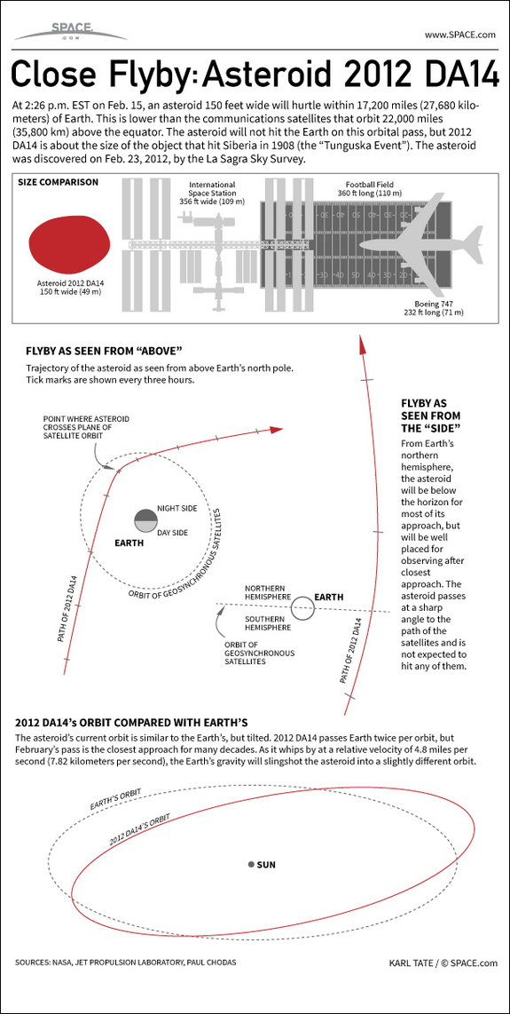
Close call: Asteroid to pass between Earth and moon, manmade satellites

2013-02-10_164421.jpg
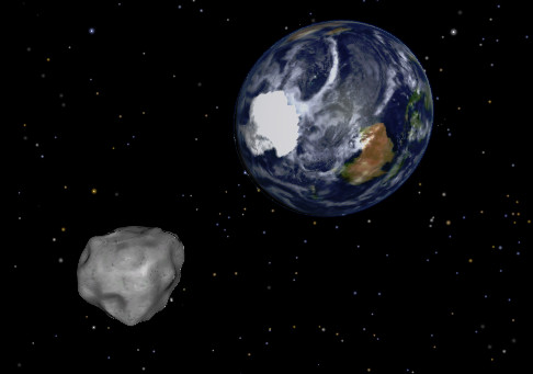
NASA depiction of asteroid 2012 DA14 as it passes by the Earth. (NASA)

Known formally as ‘Asteroid 2012 DA14’, a massive piece of rock will pass perilously close to Earth on Friday.  The 150 foot wide asteroid is similar in size to one that devastated Siberia in the early 20th century.

At its closest to the Earth, asteroid 2012 DA14 will be within 17,200 miles of Earth.  That is much closer than the orbit of the moon (239,000 miles) and in fact will pass between Earth and many of our crucial communication satellites.

More than 100 geostationary satellites are perched in orbit at 22,000 miles.  While there is no danger of 2012 DA14 hitting the Earth, there is a very remote chance it could collide with one of these manmade satellites.

NASA says that the rock is will be speeding by at 17,400 miles per hour.  2012 DA14 will be at its closest point to earth on Friday, February 15 at approximately 12:24 p.m. MST.

The daytime pass for those in North America will preclude viewing here.  However those in Indonesia, Eastern Europe, Australia and Asia should be able to view it with a small telescope.

At 150 feet across, 2012 DA14 is similar in size to an asteroid that exploded over Siberia in 1908 – the “Tunguska Event.”  That object created a blast estimated at 1,000 times more powerful that the atomic bomb dropped on Hiroshima and flatted trees across an 800 square mile area.

Asteroids this size can cause extensive regional damage but are nowhere near the scale of the 5-mile-wide one that is thought responsible for wiping out the dinosaurs.

  • Watch: NASA video explaining asteroid 2012 DA14 below the inforgraphic

See how close asteroid 2012 DA14 will come to hitting the Earth, in this SPACE.com Infographic.
Source SPACE.com: All about our solar system, outer space and exploration

NASA satellite offers up stunning view of the globe at night

A stunning nighttime view of North and South America, the west cost of Africa and Europe. (NASA) Click the image for a larger view.

The ‘blue marble’ images captured by NASA satellites are extremely popular and showcase the Earth without borders in its natural beauty.  New images dubbed ‘black marble’ show our planet at night with the lights of population dotting the landscape.

The Suomi National Polar-orbiting Partnership (Suomi NPP) satellite captured the images in April and October and were then stitched together to provide a cohesive, single view.  NASA created a matching video that shows the planet rotating as the nighttime lights rotate on it.

The imagery of the United States shows how much more densely populated the eastern half of the nation is versus the western half.  A look at Colorado shows the main population centers of the Colorado Front Range along I-25 and the many smaller communities that dot the plains and mountains.

See below for some of the stunning views and to view an animation of the Earth rotating.

The night view of the contiguous United States clearly shows where the major population centers are and highlights the more sparsely populated west. (NASA) Click the image for a larger view.
Nighttime satellite imagery of Colorado clearly shows the population centers of the Front Range. (NASA)
Nighttime satellite imagery of Colorado clearly shows the population centers of the Front Range. (NASA) Click the image for a larger view.
A zoomed in view of the Colorado Front Range and the area from Colorado Springs, through Denver and on to Cheyenne, WY. (NASA)

From NASA:

The night side of our planet twinkles with light, and the first thing to stand out is the cities. “Nothing tells us more about the spread of humans across the Earth than city lights,” asserts Chris Elvidge, a NOAA scientist who has studied them for 20 years.

This new global view and animation of Earth’s city lights is a composite assembled from data acquired by the Suomi National Polar-orbiting Partnership (Suomi NPP) satellite. The data was acquired over nine days in April 2012 and thirteen days in October 2012. It took satellite 312 orbits and 2.5 terabytes of data to get a clear shot of every parcel of Earth’s land surface and islands. This new data was then mapped over existing Blue Marble imagery to provide a realistic view of the planet.

To view the video of the night lights, click on the link below the image or visit our YouTube page. To view many more still images and maps of night lights, visit our new feature page: Earth at Night 2012.

The view was made possible by the “day-night band” of Suomi NPP’s Visible Infrared Imaging Radiometer Suite. VIIRS detects light in a range of wavelengths from green to near-infrared and uses “smart” light sensors to observe dim signals such as city lights, auroras, wildfires, and reflected moonlight. This low-light sensor can distinguish night lights tens to hundreds of times better than previous satellites.

Named for meteorology pioneer Verner Suomi, the polar-orbiting satellite flies over any given point on Earth’s surface twice each day at roughly 1:30 a.m. and 1:30 p.m. Suomi NPP orbits 824 kilometers (512 miles) above the surface as it circles the planet 14 times a day. Data is sent once per orbit to a ground station in Svalbard, Norway, and continuously to local direct broadcast users around the world. The mission is managed by NASA with operational support from NOAA and its Joint Polar Satellite System, which manages the satellite’s ground system.

Learn more about the VIIRS day-night band and nighttime imaging of Earth in our new feature story: Out of the Blue and Into the Black.

NASA Earth Observatory image and animation by Robert Simmon, using Suomi NPP VIIRS data provided courtesy of Chris Elvidge (NOAA National Geophysical Data Center). Suomi NPP is the result of a partnership between NASA, NOAA, and the Department of Defense. Caption by Mike Carlowicz.

Instrument: 

Suomi NPP – VIIRS

Remembering a national hero: NASA releases Neil Armstrong tribute video

It is fitting that Neil Armstrong's footprint will forever be on the moon just as the man remains in a nation's heart. (NASA)

There are few Americans who don’t know the name ‘Neil Armstrong’ and can’t cite the tremendous contribution the man made to exploration and our nation.  Following his passing last week, a memorial service was held today at the Washington National Cathedral and a new video tells much about the man.

On July 16, 1969, Neil Armstrong, Buzz Aldrin and Michael Collins took to the skies aboard their massive Saturn V rocket bound for the moon.  Five days later, Armstrong and Aldrin would lift the spirits of the nation and the imaginations of the world as they became the first men to walk on the moon.

Chosen because he was a civilian at the time, Armstrong would make that infamous ‘small step for [a] man, one giant leap for mankind’.  In doing so, the United States Navy veteran would forever be mentioned in the history books with the likes of Columbus, Polo, Lewis & Clark, Cook and Hillary.

We mourn the loss of this national hero but thank the Lord for a man who gave so much to his country.  As we wrote last week, “May he rest in peace and may one day our nation find the will to continue on the path which he and so many of his predecessors put us on.”

Rest in peace, Neil.

NASA image: Spacewalking astronaut ‘touches the sun’

While they are viewed by the public these days as routine, there can hardly be a more dangerous – or thrilling – task for an astronaut to perform than a spacewalk.  The imagery captured by these modern day explorers is nothing short of amazing as seen in a photo of NASA astronaut Sunita Williams seemingly touching the sun during a spacewalk last week.

During an extravehicular activity (EVA) aboard the International Space Station, Williams and Japan Aerospace Exploration Agency astronaut Aki Hoshide performed much-needed maintenance and repairs to the orbiting platform.  During the six-hour, 28-minute spacewalk Hoshide captured an image of Williams appearing to reach for the sun at one point during the EVA.

NASA astronaut Sunita Williams, Expedition 32 flight engineer, appears to touch the bright sun during the mission’s third session of extravehicular activity (EVA) on Sept. 5, 2012.  (NASA)
NASA astronaut Sunita Williams, Expedition 32 flight engineer, appears to touch the bright sun during the mission’s third session of extravehicular activity (EVA) on Sept. 5, 2012. (NASA) Click the image for a larger view.