All posts by Thornton Weather

ThorntonWeather.com is your local source for live Thornton, Colorado weather conditions and news!

NASA says global warming will increase severe storms

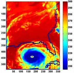
Extremely high clouds, known as deep convective clouds, are typically associated with severe storms and rainfall. In this AIRS image of Hurricane Katrina, taken August 28, 2005, the day before Katrina made landfall in Louisiana, the eye of the storm was surrounded by a "super cluster" of 528 deep convective clouds (depicted in dark blue). The temperatures of the tops of such clouds are colder than 210 degrees Kelvin (-82 degrees Fahrenheit). Image credit: NASA/JPL

Scientists are NASA’s Jet Propulsion Laboratory in Pasadena, CA recently released the results of a study that determined that global warming is causing an increase in high clouds and a corresponding increase in severe storms and rainfall.  This is not unlike previous warnings issued by some scientists, in particular those warnings of an increase in hurricane intensity and frequency in the Atlantic.  Thus far those previous warnings have not bore out.  Will this one? 

Here are the details on the new study:

From:  NASA / JPL
December 19, 2008

PASADENA, Calif. — The frequency of extremely high clouds in Earth’s tropics — the type associated with severe storms and rainfall — is increasing as a result of global warming, according to a study by scientists at NASA’s Jet Propulsion Laboratory, Pasadena, Calif.

In a presentation today to the fall meeting of the American Geophysical Union in San Francisco, JPL Senior Research Scientist Hartmut Aumann outlined the results of a study based on five years of data from the Atmospheric Infrared Sounder (AIRS) instrument on NASA’s Aqua spacecraft. The AIRS data were used to observe certain types of tropical clouds linked with severe storms, torrential rain and hail. The instrument typically detects about 6,000 of these clouds each day. Aumann and his team found a strong correlation between the frequency of these clouds and seasonal variations in the average sea surface temperature of the tropical oceans.

For every degree Centigrade (1.8 degrees Fahrenheit) increase in average ocean surface temperature, the team observed a 45-percent increase in the frequency of the very high clouds. At the present rate of global warming of 0.13 degrees Celsius (0.23 degrees Fahrenheit) per decade, the team inferred the frequency of these storms can be expected to increase by six percent per decade.

Climate modelers have long speculated that the frequency and intensity of severe storms may or may not increase with global warming. Aumann said results of the study will help improve their models.

“Clouds and rain have been the weakest link in climate prediction,” said Aumann. “The interaction between the daytime warming of the sea surface under clear-sky conditions and increases in the formation of low clouds, high clouds and, ultimately, rain is very complicated. The high clouds in our observations—typically at altitudes of 20 kilometers (12 miles) and higher—present the greatest difficulties for current climate models, which aren’t able to resolve cloud structures smaller than about 250 kilometers (155 miles) in size.”

Aumann said the results of his study, published recently in Geophysical Research Letters, are consistent with another NASA-funded study by Frank Wentz and colleagues in 2005. That study found an increase in the global rain rate of 1.5 percent per decade over 18 years, a value that is about five times higher than the value estimated by climate models that were used in the 2007 report of the Intergovernmental Panel on Climate Change.

JPL manages the AIRS project for NASA’s Science Mission Directorate, Washington. For more information on AIRS, visit http://airs.jpl.nasa.gov/ .

JPL is managed for NASA by the California Institute of Technology in Pasadena.

Batten down the hatches – here comes the wind again

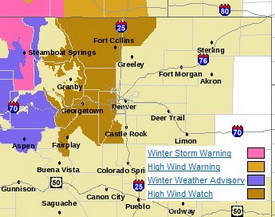
Much of the western and northern Front Range will be under a High Wind Watch starting tonight.

The relative calm of recent days is about to be replaced with high winds not unlike what we saw last week.   Winds will increase tonight and continue through Wednesday east of the Continental Divide.  Areas west of I-25 to the Divide and in the north and central mountain areas will be under a High Wind Watch from late tonight through Wednesday night. 

Much like last week, the usual suspect areas west of I-25 are the places to watch.  Fort Collins, Boulder and the western suburbs of Denver are going to get the worst of the wind.  The Peak to Peak Highway, Highway 287 north of Fort Collins, the Boulder Turnpike west of Broomfield, and Highway 93 between Boulder and Golden are naturally going to be prime targets. 

Wind gusts in excess of 80 mph can be expected in these areas but as we saw last week, other parts of the metro area can receive their fair share of wind as well.  As usual, it is best to put away anything in your yards that could be become a missile and if you are driving in the high wind areas, particular along a north / south route, be prepared for extremely gusty conditions.

Get more local news and weather information on Examiner.com.
This article and many more are posted to the Denver Weather Examiner site.
Visit Examiner.com for more local Denver news and weather.

The good news is that the downslope winds will also bring warmer temperatures – not that you will want to be outside in the wind.  Wednesday we will be well above normal with temperatures in the mid 50’s and Thursday could reach the low 60’s.  There is a slight chance of snow Friday but that isn’t looking to amount to much.

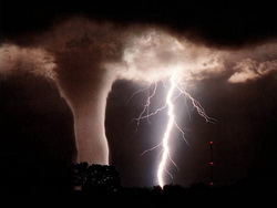
2008 had second highest number of tornadoes on record

2008 will go down as the second most active year for tornadoes on record.

According to the latest data from the Storm Prediction Center, the number of confirmed tornadoes in 2008 will finish well above average.  Final numbers through the end of October count 1,621 twisters, exceeding the average over the last ten years of 1,270 per year. 

Once the data is finalized, the year will most likely go down as the second most active tornado year on record since record keeping began in 1950.  2004 was the most active year with 1,871 and the number three year was 1998 with 1,424. 

While some alarmists may look to climate change as a reason for what seems to be an increase in the number of twisters, the explanation is actually much simpler than that.  Technology like radar now allows us to ‘see’ tornadoes in rural areas that normally would have gone unreported.  Further, as population grows, there are simply more people living in areas that were unpopulated before and thus twisters are spotted more often. 

Get more local news and weather information on Examiner.com.
This article and many more are posted to the Denver Weather Examiner site.
Visit Examiner.com for more local Denver news and weather.

What about Colorado?  Certainly we all remember the Windsor tornado in May.  Beyond that, there were a total of 61 tornado reports in 2008.  The actual number of twisters will certainly be lower than that once duplicate reports are removed and the tally is official.

TORNADO TOTALS AND RELATED DEATHS...THROUGH 12/31/2008
NWS STORM PREDICTION CENTER NORMAN OK
0726 AM CST THU JAN 01 2009

    ...NUMBER OF TORNADOES...            NUMBER OF        KILLER
                                       TORNADO DEATHS    TORNADOES
     ..2008..  ..2007.. 2006 2005  3YR            3YR            3YR
    PREL  ACT PREL  ACT  FIN  FIN   AV 08 07 06 05 AV 08 07 06 05 AV
JAN  136   84   29   21   47   33   34  7  2  1  4  2  4  1  1  2  1
FEB  230  148   87   52   12   10   25 59 22  0  0  7 12  3  0  0  1
MAR  150  126  214  171  150   62  128  4 27 11  1 13  3 10  7  1  6
APR  189  189  187  165  245  132  181  0  9 38  0 16  0  3  9  0  4
MAY  597  460  282  250  139  123  171 43 14  3  0  6 10  4  1  0  2
JUN  394  289  152  128  120  316  188  7  0  0  0  0  4  0  0  0  0
JUL  120   94   55   69   71  138   93  1  0  0  0  0  1  0  0  0  0
AUG  145   99   87   73   80  123   92  0  1  1  4  2  0  1  1  3  2
SEP  133  111   63   51   84  133   89  2  0  1  1  1  1  0  1  1  1
OCT   28   21  115   87   76   18   60  0  5  0  0  2  0  3  0  1  1
NOV   20    -    7    7   42  150   66  2  0 10 28 13  2  0  3  5  3
DEC   50    -   22   19   40   26   33  0  1  2  0  1  0  1  2  0  1
    ----  --- ---- ---- ---- ---- ---- --- -- -- -- -- -- -- -- -- --
SUM 2192 1621 1300 1093 1106 1264 1159 125 81 67 38 62 37 26 25 13 21

PREL = 2009 PRELIMINARY COUNT FROM NWS LOCAL STORM REPORTS.
ACT = ACTUAL COUNT BASED ON NWS STORM DATA SUBMISSIONS.

TORNADO-RELATED FATALITY NUMBERS ARE ENTERED WHEN CONFIRMED BY NWS
FORECAST OFFICES.

Top weather story of 2008 – The Windsor tornado

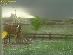
This amazing image of the Windsor tornado was taken from a backyard webcam. Image courtesy MyWindsorWeather.com.

May 22, 2008 started like most other spring days in Colorado.  That Thursday morning had dawned with relatively mild temperatures and a touch of humidity in the air.  That moisture in the air was a warning sign as moist air from the Gulf of Mexico was entering the state and a signal of the potential for severe storms.  No one knew though just what was in store for a small town in northeastern Colorado.

As temperatures rose in the morning, the moist air near the ground mixed with fast moving dry air aloft and created conditions ideal for supercell thunderstorms and tornadoes.  Hail began to fall around 11:20am near Platteville, a harbinger of things to come.  As the weather situation became much more excited and confused, reports of a twister on the ground near Gilcrest at 11:29 rolled in.

A classic wedge tornado had formed and was moving to the north-northwest at a leisurely 30 mph wreaking havoc and destruction all along its path.  Examiner.com soon posted a special report at 11:30 warning of the twister and showing its expected path.  It narrowly missed the town of Milliken, dumping baseball sized hail on it instead.  The twister was now a full mile wide with winds in excess of 136 mph and at 11:57am, the storm struck Windsor, home to 16,000 Coloradoans.  By the time it was done with the town, it had claimed one life, destroyed 80 homes and damaged nearly 770 others.

For a total of nearly 45 minutes the storm carved a 35 mile long path of devastation and all along its path it left the evidence – houses with nothing but a foundation left, power poles snapped like matchsticks, semi-trailers overturned like toy cars, mangled pieces of metal and shards of wood.

Tornadoes in Colorado are not uncommon with an average of 60 per year, although most do occur on the eastern plains in more rural areas.  The storm was only the second deadly tornado in Colorado in the last 10 years (the Holly tornado in 2007 being the other) but it served to highlight that the Front Range is on the western edge of Tornado Alley.  Weld County is in fact Colorado’s own tornado capital having had more twisters than any other county since 1950.

When it was over, Coloradoans showed their sense of community in helping the affected areas.  The Red Cross immediately went into action as did the state government in calling out the National Guard to help.  Donations poured in and other relief agencies provided food and shelter to those left homeless.  While the Windsor Tornado was an example of the worst of Mother Nature, the storm also showed us the best of mankind.  No other weather event comes close to being Colorado’s biggest weather story of 2008.

Below is some amazing raw video from 9News of the tornado as it moved north.

Strong winds hit Thornton and the Front Range

High winds hit the metro area on Tuesday morning.

High winds have hit the Front Range with gusts exceeding 80mph in some areas.  These winds are extremely gusty and have the potential to cause damage and can make driving conditions difficult.  

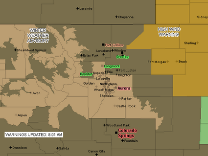
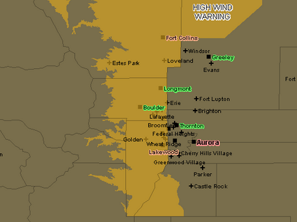
A High Wind Warning remains in effect for much of the Front Range and foothills until 8:00am (see area map below).  While Thornton is not in the warning area, we have received our fair share as ThorntonWeather.com recorded a 51mph gust earlier this morning.  In the near term, west winds of 15 to 30 mph gusting to 45 mph are expected all along the I-25 corridor.  Gusts as high as 75 mph will occur near the base of the foothills and areas in northern Jefferson County, Boulder County and Larimer County in particular will receive the highest winds. 

These winds will cause blowing dust and drivers on north-south roads need to be wary as the cross winds could cause a loss of control.  It would not be surprising to hear of accidents with light weight or high profile vehicles this morning.  Power outages are of course a possibility as well. 

From the National Weather Service, here are some of the recorded gusts across the Front Range:

05:48 AM   12/30/2008    REPORTED BY: ASOS
BROOMFIELD COUNTY, CO   –  2 MILES WEST-NORTHWEST OF BROOMFIELD
NON-T-STORM WIND GUST  MEASURED AT 78.00 MPH   ROCKY MOUNTAIN REGIONAL AIRPORT
 
05:48 AM   12/30/2008    REPORTED BY: TRAINED SPOTTER
LARIMER COUNTY, CO   –   MASONVILLE
NON-T-STORM WIND GUST  MEASURED AT 59.00 MPH    
 
05:15 AM   12/30/2008    REPORTED BY: TRAINED SPOTTER
BOULDER COUNTY, CO   –  1 MILE SOUTHWEST OF ERIE
NON-T-STORM WIND GUST  MEASURED AT 77.00 MPH    
 
04:45 AM   12/30/2008    REPORTED BY: TRAINED SPOTTER
BOULDER COUNTY, CO   –  1 MILE SOUTHWEST OF ERIE
NON-T-STORM WIND GUST  MEASURED AT 66.00 MPH    
 
04:20 AM   12/30/2008    REPORTED BY: MESONET
BOULDER COUNTY, CO   –  2 MILES SOUTHWEST OF BOULDER
NON-T-STORM WIND GUST  MEASURED AT 69.00 MPH   NCAR MESA LAB
 
03:28 AM   12/30/2008    REPORTED BY: TRAINED SPOTTER
WELD COUNTY, CO   –  21 MILE NORTH OF NEW RAYMER
NON-T-STORM WIND GUST  MEASURED AT 76.00 MPH    
 
02:48 AM   12/30/2008    REPORTED BY: TRAINED SPOTTER
JEFFERSON COUNTY, CO   –   LAKEWOOD
NON-T-STORM WIND GUST  MEASURED AT 66.00 MPH    
 
02:10 AM   12/30/2008    REPORTED BY: MESONET
BOULDER COUNTY, CO   –  1 MILE WEST OF ELDORADO SPRINGS
NON-T-STORM WIND GUST  MEASURED AT 66.00 MPH    
 
12:30 AM   12/30/2008    REPORTED BY: MESONET
BOULDER COUNTY, CO   –  2 MILES NORTH-NORTHEAST OF BOULDER
NON-T-STORM WIND GUST  MEASURED AT 67.00 MPH    
 
12:30 AM   12/30/2008    REPORTED BY: MESONET
JEFFERSON COUNTY, CO   –  9 MILES WEST-SOUTHWEST OF BOULDER
NON-T-STORM WIND GUST  MEASURED AT 82.00 MPH   ROCKY FLATS – NATIONAL WIND TECHNOLOGY CENTER
 
11:15 PM   12/29/2008    REPORTED BY: TRAINED SPOTTER
BOULDER COUNTY, CO   –  2 MILES NORTH OF LONGMONT
NON-T-STORM WIND GUST  MEASURED AT 84.00 MPH    
 
10:39 PM   12/29/2008    REPORTED BY: TRAINED SPOTTER
LARIMER COUNTY, CO   –  BERTHOUD
NON-T-STORM WIND GUST  MEASURED AT 91.00 MPH   CARTER LAKE
 
09:36 PM   12/29/2008    REPORTED BY: TRAINED SPOTTER
BOULDER COUNTY, CO   –  2 MILES NORTH OF LONGMONT
NON-T-STORM WIND GUST  MEASURED AT 71.00 MPH    
 
09:14 PM   12/29/2008    REPORTED BY: MESONET
JEFFERSON COUNTY, CO   –   ROCKY FLATS
NON-T-STORM WIND GUST  MEASURED AT 78.00 MPH    
 
09:06 PM   12/29/2008    REPORTED BY: TRAINED SPOTTER
LARIMER COUNTY, CO   –  BERTHOUD
NON-T-STORM WIND GUST  MEASURED AT 88.00 MPH   AT CARTER LAKE
 
07:35 PM   12/29/2008    REPORTED BY: MESONET
BOULDER COUNTY, CO   –  2 MILES SOUTH OF BOULDER
NON-T-STORM WIND GUST  MEASURED AT 65.00 MPH   NCAR MESA LABS
 
07:21 PM   12/29/2008    REPORTED BY: MESONET
BOULDER COUNTY, CO   –  3 MILES EAST OF GOLD HILL
NON-T-STORM WIND GUST  MEASURED AT 81.00 MPH    


A High Wind Warning is in effect for much of the western part of the Front Range through 8:00am Tuesday.

January 2009 weather preview available

A preview of January 2009's weather.

As we continue on what has been a relatively dry season thus far, cold and dry are the key words to remember when it comes to January. The month is the coldest of the year and the second driest as well. Just how cold can January get? The record low temperature for each day of the month is at least 10 degrees below zero.

Just what can we expect in January 2009?  Click here to read our January weather preview.

White Christmas for half the country as travel woes continue

Old Man Winter brought a white Christmas to much of the northern half of the United States which may be a blessing or a curse depending on your point of view.  Images released by the National Operational Hydrologic Remote Sensing Center  show that many areas that wouldn’t normally expect snow are covered in a blanket of white this Christmas.

Much of the country west of the Continental Divide will have snow or rain Christmas Day.  Areas of the Sierra Nevada and southwestern Colorado will be measuring the snow in feet.  Salt Lake City is expecting 4 to 8 inches while here in Denver we remain dry and will actually have a pretty mild day. 

In the northeast they will have a cold and blustery holiday.  Lake Erie and Lake Ontario will generate some lake-effect snows from Pennsylvania through New York and into northern New England. 

The latest cold blast to hit the nation has caused travel woes across much of it.  In Chicago, 500 flights were canceled on Tuesday stranding many travelers, some of whom won’t be able to reach their destination until today.  100 flights were canceled at O’Hare Wednesday but delays improved as the day went on.  Sadly the weather did have a more serious toll as between Tuesday and Wednesday at least 30 people were killed in crashes on rain- and ice-slickened roads across the nation’s midsection. 

Out west in Washington and Oregon, residents and government officials were wishing for a return to their normal rainy weather as they were unprepared for the snow that has fallen in recent days.  In Portland, Oregon many side streets were impassable without chains or four wheel drive.  Wednesday more snow fell followed by rain which most likely will add to the problems when it freezes tonight.

Washington Governor Chris Gregoire declared a statewide winter storm emergency saying, “A number of counties and cities are struggling to meet the problems posed by this month’s onslaught of snow and winter weather.  Snowfall has reached record or near-record level in 30 of the state’s 39 counties.”  Her proclamation will allow state agencies to support local operations including the activation of the National Guard. 

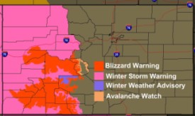
Active weather watches and warnings on Christmas Day.Here in Colorado, much of the western slope is under various types of winter weather advisories.  A Winter Storm Warning covers the western half of the state and Blizzard and Avalanche Warnings cover some areas south of I-70.  Needless to say, Christmas Day travel in the high country will be greatly impeded by these storms.  

Good weather along the eastern part of Colorado has allowed Denver International Airport to operate normally for the most part.  However, some delays were experienced for flights heading to other parts of the nation affected by the winter weather. 

Weather Geek Stuff shown on the Weather Channel

Weather Geek Stuff is a new site with a wide array of weather related clothing and novelties. The site was recently shown on The Weather Channel.

You have read about Weather Geek Stuff (www.weathergeekstuff.com) in our news pages before.  It is a great site to buy clothing, novelties and much more for yourself or the weather geek in your life. 

Yesterday, Weather Geek Stuff was proudly plugged on The Weather Channel during one of their segments talking about gifts for weather enthusiasts.  It was of course pretty exciting to see.  You can watch the video below.

Powered by Café Press, we have created a bunch of “Weather Geek” logo merchandise for sale on WeatherGeekStuff.com.  There is even “Weather Diva” logo merchandise stuff for ladies and kids can get stuff in their size as well.  We have also created some ‘warning sign’ logos that are pretty amusing that can be put on all sorts of different items.  If you are a huge fan of ThorntonWeather.com, you can get merchandise with our logo too. Everything from t-shirts to polo shirts and from coffee mugs to clocks are available, all with a cool logos and graphics.

Dreaming of a white Christmas? The chances are slim

What are the odds of a white Denver Christmas?  Not very good.
What are the odds of a white Denver Christmas? Not very good.

As Christmas gets closer everyone always wonders if we are going to get the proverbial white Christmas. Unfortunately, if you look at Denver and Thornton weather history, the chances arent all that good but it also depends on what you define as a white Christmas. December just isnt that snowy of a month, ranking as only the fourth snowiest (behind March, November and April) so historically we have a bit of a disadvantage.

For a complete look at Denver’s Christmas weather statistics, click here.

CNN meteorologist calls manmade global warming theory ‘arrogant’

It would seem that the debate on global warming and manmade climate change isn't over yet.

CNN weather anchor Chad Myers appeared on Lou Dobbs Tonight earlier this week and he had had some pretty stark comments on manmade global warming.  Calling the theory ‘arrogant’ and declaring that the data on which it is based short-sighted and faulty, Myers adds his voice to a growing chorus of dissenting opinions on the impact man has on the climate and is on the heels of last week’s news of 650 international scientists announcing their disagreement with the manmade global warming claims of the United Nations.

To think we could affect weather all that much is pretty arrogant.

– Chad Myers, CNN Meteorologist

Myers continued:

“Mother Nature is so big. The world is so big. The oceans are so big. I think we’re going to die from a lack of fresh water or die from ocean acidification before we die from global warming, for sure. But this is like you said, in your career; my career has been 22 years long. That’s a good career in TV. But in talking about climate, it is like having a car for three days and saying this is a great car. Yes, it was for three days, but maybe in day five, six and seven it won’t be so good. That’s what we’re doing here. We have a hundred years worth of data, not millions of years that the world has been around.”

This was a pretty interesting exchange.  Check out the video below.  You can also find a transcript here.

This article was also posted to the Denver Weather Examiner site. Get more local news and information on Examiner.com.  Denver Weather Examiner